EP1092950A1 - Procédé pour déterminer le trajet d'un véhicule - Google Patents
Procédé pour déterminer le trajet d'un véhicule Download PDFInfo
- Publication number
- EP1092950A1 EP1092950A1 EP00120432A EP00120432A EP1092950A1 EP 1092950 A1 EP1092950 A1 EP 1092950A1 EP 00120432 A EP00120432 A EP 00120432A EP 00120432 A EP00120432 A EP 00120432A EP 1092950 A1 EP1092950 A1 EP 1092950A1
- Authority
- EP
- European Patent Office
- Prior art keywords
- route
- destination
- databases
- routes
- map data
- Prior art date
- Legal status (The legal status is an assumption and is not a legal conclusion. Google has not performed a legal analysis and makes no representation as to the accuracy of the status listed.)
- Withdrawn
Links
Images


Classifications
-
- G—PHYSICS
- G01—MEASURING; TESTING
- G01C—MEASURING DISTANCES, LEVELS OR BEARINGS; SURVEYING; NAVIGATION; GYROSCOPIC INSTRUMENTS; PHOTOGRAMMETRY OR VIDEOGRAMMETRY
- G01C21/00—Navigation; Navigational instruments not provided for in groups G01C1/00 - G01C19/00
- G01C21/26—Navigation; Navigational instruments not provided for in groups G01C1/00 - G01C19/00 specially adapted for navigation in a road network
- G01C21/34—Route searching; Route guidance
- G01C21/3446—Details of route searching algorithms, e.g. Dijkstra, A*, arc-flags or using precalculated routes
Definitions
- the invention relates to a method for determining a route for a Road vehicle between a start and a destination with inclusion of at least two databases with map data. Furthermore, the Invention a navigation system of a motor vehicle with a computing unit to calculate a route between a start and a destination, a reading device connected to the computing unit for reading map data from a data carrier, means for determining the vehicle position, an input unit connected to the computing unit and one with the Processing unit connected output unit.
- CD-ROMs are usually used as data carriers for the map data. so that the reader is a CD drive.
- a CD-ROM is the map data of a geographically limited one Area saved. Usually it is the map data of one certain country. A driver who crosses national borders must therefore change the CD-ROM when crossing the national border in order to continue to route guidance information to its desired destination receive.
- the object of the invention is a method for determining a route for a road vehicle between a start and a destination, where the start and destination are stored in different databases are. Furthermore, it is an object of the invention to provide a navigation system with which such a method is carried out particularly advantageously can be.
- the first-mentioned problem is solved by a method for determination a route for a road vehicle between a start and a Destination including at least two databases with map data to neighboring geographic areas by determining common boundary points from databases to neighboring geographical Areas, calculating the first partial routes between the starting point and the common border points with the map data of a first one Database containing the starting location, storing route parameters to the first partial routes, calculation of second partial routes between the destination and the common border points with the map data of a second Database containing the destination, storing route parameters to the second sub-routes, selecting a route between the start and destination based on route parameters of the overall route, which result from route parameters of the partial routes.
- the transition points are thus first (Border points) of neighboring geographical areas whose Map data are stored in various databases. Cover the databases that contain the starting point or the destination, geographical Areas that directly adjoin each other, for example sufficient to determine only one set of limit points.
- the first partial routes between the starting point and are calculated these limit points and a second calculation of partial routes between the destination and these border points.
- route parameters for the partial routes and is saved based on the route parameters determines the optimal route between the start and destination.
- the route parameters in particular, it can be the journey time or the distance traveled act on the sub-routes.
- different sets of common boundary points of databases too neighboring geographic areas. For example first partial routes between the starting point and a first set of border points that determines the geographic area that contains the starting location with a connect neighboring geographic area.
- second Sub-routes between the destination and a second set of border points calculates the boundary points between the geographic area that the Contains destination, and are a neighboring geographic area.
- Under Circumstances may have to be shared, if necessary several times Boundary points between neighboring geographic areas are determined between which partial routes are calculated.
- first partial routes between the Starting location and all limit points calculated by the database containing the starting location contains, to all other available databases. The same goes for for the destination.
- driving routes included in the calculation that include third countries. Depends on the Location of the start and destination and the course of the border can shorten this Lead times.
- the method can generally be used for route planning, for example even before starting the trip on a PC, but it is especially for Execution provided in a navigation system for motor vehicles, In In this case, after selecting a route based on the route parameters Route guidance information is output between the start and destination. If the databases are stored on different data carriers, which is usually the case with cross-border journeys preferably provided that the change of disk automatically he follows. If the data carriers are CD-ROMs, then this is called Reader preferred a CD changer. In this case there is no manual Insert additional CD-ROMs.
- a navigation system is therefore characterized in that that the reader for holding several exchangeable data carriers, as well as for selectively reading out data from one of the data carriers is and the route calculation including map data takes place, which are stored on several data carriers.
- Map data for each country in a database on a CD-ROM are saved.
- a geographic area is therefore identical to one Country.
- this is not a limitation of the invention. Rather, it can the invention can be used for general geographic areas that do not have to be limited by national borders.
- FIG. 1 shows a flow chart of a method according to the invention for a Route calculation via two databases.
- step S1 the start and the destination is given. This can happen, for example, in that both are entered directly via an input unit, in the case of a Navigation system, it is also possible that the starting point as the current position of the vehicle automatically, for example via Satellite navigation is determined and only the destination entered or off selected from a list. It is then checked in step S2 whether the Start and destination on the first CD-ROM (hereinafter abbreviated CD) is available. If this is the case, then step S2a can be carried out directly in a known manner The route calculation is done and then the route guidance information output to the calculated route (step S2b).
- CD CD-ROM
- Step S2 determines that the start and / or destination is not on the first CD is present, the CD is changed (step S3) and it is in step S4 checked whether the start and / or destination are available on the second CD. are Both the start and destination are available on the second CD, as above already described in step S2a the route calculation and subsequently the Output of the route guidance information in step S2b.
- step S2 or S4 Query whether the start and destination are on a CD and between
- steps S2 and S4 in step S3 only the CD is changed.
- the limit points can also be set after step S2 read from the first CD. In this case, the Steps S5 and S6. The somewhat longer time between execution is disadvantageous of steps S2 and S4.
- FIG. 1b shows the further course of the method after the common one has been selected Limit points shown in step S8.
- the step S9 now takes place Route planning between the start or destination and the border points, each according to which of the two places on the currently inserted CD is available.
- the calculated routes are then in step S10 Route parameters, such as the travel time or the route saved.
- the CD is then changed in step S11 and in Step S12 the route planning between the destination or start location and Boundary points carried out, depending on which of the two places still no calculations have been made.
- These routes are also in step S13 Route parameters saved.
- the route parameters are then used Determination of the optimal route between the start and the destination and thus also the selection of the optimal limit point (step S14).
- step S15 it is checked in step S15 whether the currently inserted CD is the starting location contains. If this is the case, the route calculation is between in step S17 the starting point and the selected optimal limit point. If the CD does not contain the start location in step S15, then in step S16 CD changed. After calculating the exact route between the starting point and the limit point in step S17 then becomes the route guidance information in S18 issued to the driver. In step S19 it is checked whether whether the border point has been reached. If not, so be it the route guidance information is also output in step 18. Will be against it is determined in step 19 that the limit point has been reached then the CD changed in step S20 and the route calculation in step S21 between the selected optimal limit point and the Destination carried out. The route guidance information for the second section between the border point and the destination.
- steps S10 and S13 the complete route guidance information as route parameters can be stored, steps S15 to S21 omitted.
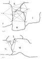
- FIG. 2 is a schematic map representation has explained in more detail.
- two neighboring ones are geographical limited areas, namely countries A and B.
- the map data for each of countries A and B are available on a separate CD.
- the Starting point S is in country A, while destination Z is in country B.
- the border points G1, G2 and G3 are common border points of countries A and B and hence the corresponding databases on the two CDs.
- the first step will be the first partial routes between the starting point S and the common limit points G1, G2 and G3 are calculated. To these three sub-routes the travel times are saved as route parameters.
- the destination Z contains, the partial routes between the destination Z and the common border points G1, G2 and G3 determined. They also become these three sub-routes Route parameters saved. Then, using the route parameters determines the optimal route between the starting point S and the destination Z.
- this can lead, for example, over the border location G1.
- This is then based on the map data that the starting point S included, the complete route between the starting point S and the selected one optimal limit point G1 fully calculated and the corresponding Route guidance information for the journey from starting point S to the border point G1 issued.
- the limit point G1 is reached, the CD changed and the entire route from border point G1 to Destination Z calculated. Then again the route guidance information until the destination Z is reached.
- FIG. 3 shows an example in which the starting point S and the destination Z not in neighboring countries.
- the starting point S is in country C, while The destination Z is in country E, with country D between countries C and E. lies.
- the map data for each of the countries C, D, E are on a separate one CD saved.
- To calculate the route between the starting point S and The destination Z is now proceeded so that the boundary points between the countries C and D, i.e. the border points G4, G5 and G6 as well the border points between the countries D and E, i.e. the border points G7, G8 and G9 can be determined.
- a search ellipse can be generated on the basis of this vector that limits the choice of border locations. This can an acceleration of the process can be achieved.
- the route parameters of the calculated partial routes then become optimal route, for example the route with the shortest travel time, from Start location to destination selected.
- the optimal Border locations set. For example, a route from Starting point S above border point G5 to border point G8 and from there to Point out destination Z as the optimal route so that the limit points G5 and G8 are hereby established.
- This is followed by a first step an exact route calculation from the starting point S to the border point G5 with the Map data of the CD for the country C.
- the border point G5 is reached then the CD is changed and the CD for country D is inserted, see above that route calculation takes place from the boundary point G5 to the boundary point G8 can.
- the CD is changed again and now inserted the CD with the map data of the country E, so that a route can be calculated from the boundary point G8 to the destination Z.
- this is the border point at G10 Country F, the border point G13 to country H and the border points G14 and G15 to country I.
- these are the border points G11 and G12 to country F, G13 to country K and G16 and G17 to country I.
- country I all boundary points to neighboring and existing as a database countries selected.
- FIG. 5 shows a further example in which the starting location S and the Destination Z in neighboring countries, namely countries N and M, are located Use of additional map data of a third country from Can be an advantage. Due to the geographical situation, a route can be taken from starting point S to destination Z through country L via border points G18 and G20 be cheaper than a trip across the common border between the countries N and M and the border point G19. Choosing the optimal route is done here based on three databases in a similar way as in context described with Figure 3.
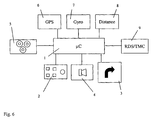
- the components of a motor vehicle navigation system are shown in FIG Implementation of the method according to the invention is shown schematically.
- the central component of the navigation system is the computing unit 1, which also contains the necessary storage elements.
- the computing unit 1 is one Control unit 2 connected via which, for example, the destination is entered or can be selected.
- the control unit 2 can be in the same housing as the computing unit 1 can be accommodated, but the control unit 2 can also be designed as a remote control, for example with the computing unit 1 is connected via an optical interface or a radio interface.
- An optical output unit 3 is connected to the computing unit 1, via which Route guidance information and other information are output. The Route guidance information can also be heard acoustically via a loudspeaker 4 be issued.
- the computing unit 1 is also equipped with a reader 5 connected, which reads the map data from a data carrier.
- the data carrier can be a CD, for example.
- the data carrier can be a CD, for example.
- the CD drive is a CD changer acts, since then several CDs can be inserted and the selection of the just needed CD can be done automatically.
- the control of the Drive 5 is carried out by the computing unit 1.
- Using the map data, that are stored on the CDs can be in the optimal route is calculated in the manner described above to which route guidance information is then provided via the optical output unit 3 can be spent.
- the navigation system also contains a receiver 6 for Reception of satellite navigation signals.
- the navigation system contains the ability to determine the position furthermore a direction sensor 7 and a displacement sensor 8, which also with the computing unit 1 are connected so that with the aid of a suitable computer program a position determination is possible with these signals.
- the computing unit 1 in the example shown is additionally equipped with a Broadcast receiver 9 connected to receive RDS / TMC signals is trained. This allows traffic information received from the radio receiver 9 forwarded to the computing unit 1 and for consideration are used in the route calculation.
Landscapes
- Engineering & Computer Science (AREA)
- Radar, Positioning & Navigation (AREA)
- Remote Sensing (AREA)
- Automation & Control Theory (AREA)
- Physics & Mathematics (AREA)
- General Physics & Mathematics (AREA)
- Navigation (AREA)
- Traffic Control Systems (AREA)
Applications Claiming Priority (2)
| Application Number | Priority Date | Filing Date | Title |
|---|---|---|---|
| DE19947789 | 1999-10-05 | ||
| DE1999147789 DE19947789A1 (de) | 1999-10-05 | 1999-10-05 | Verfahren zur Bestimmung einer Fahrtroute für ein Strassenfahrzeug |
Publications (1)
| Publication Number | Publication Date |
|---|---|
| EP1092950A1 true EP1092950A1 (fr) | 2001-04-18 |
Family
ID=7924465
Family Applications (1)
| Application Number | Title | Priority Date | Filing Date |
|---|---|---|---|
| EP00120432A Withdrawn EP1092950A1 (fr) | 1999-10-05 | 2000-09-19 | Procédé pour déterminer le trajet d'un véhicule |
Country Status (2)
| Country | Link |
|---|---|
| EP (1) | EP1092950A1 (fr) |
| DE (1) | DE19947789A1 (fr) |
Cited By (5)
| Publication number | Priority date | Publication date | Assignee | Title |
|---|---|---|---|---|
| WO2006018337A1 (fr) * | 2004-08-14 | 2006-02-23 | Robert Bosch Gmbh | Procede de navigation |
| CN100335862C (zh) * | 2003-05-14 | 2007-09-05 | 行毅科技股份有限公司 | 越野导航远程控制系统及车载越野导航系统 |
| US7596542B1 (en) * | 2004-05-25 | 2009-09-29 | Allstate Insurance Company | Systems and methods for creating geographic connection matrices |
| EP2273231A4 (fr) * | 2008-04-28 | 2011-05-04 | Navitime Japan Co Ltd | Système et procédé de guidage routier, serveur de recherche de route et terminal |
| GB2505464A (en) * | 2012-08-31 | 2014-03-05 | Bae Systems Plc | Iterative route planning using a pre-determined seed-set of optimal routes |
Families Citing this family (3)
| Publication number | Priority date | Publication date | Assignee | Title |
|---|---|---|---|---|
| TW200424963A (en) * | 2003-05-02 | 2004-11-16 | Sin Etke Technology Co Ltd | Cross country navigation system |
| CN102209880A (zh) * | 2008-11-07 | 2011-10-05 | 株式会社纳维泰 | 路径向导中介系统、路径向导中介服务器及路径向导方法 |
| DE102011113419A1 (de) | 2011-09-15 | 2013-03-21 | GM Global Technology Operations LLC (n. d. Gesetzen des Staates Delaware) | Verfahren zum Ermitteln einer zwischen einem Anfangsort und einem Endort verlaufenden Fahrtroute unter Berücksichtigung von Gebietsbedingungen verschiedener Gebiete, Routenplanungsvorrichtung und Kraftfahrzeug |
Citations (5)
| Publication number | Priority date | Publication date | Assignee | Title |
|---|---|---|---|---|
| JPH037983A (ja) * | 1989-06-05 | 1991-01-16 | Alpine Electron Inc | 地図用記憶媒体の交換方法 |
| JPH0546090A (ja) * | 1991-08-15 | 1993-02-26 | Sony Corp | 情報検索システムおよびナビゲーシヨンシステム |
| US5412573A (en) * | 1993-05-20 | 1995-05-02 | Motorola Inc. | Multi-mode route guidance system and method therefor |
| EP0726447A1 (fr) * | 1995-02-09 | 1996-08-14 | Zexel Corporation | Calcul de route incrémental |
| EP0798539A2 (fr) * | 1996-03-29 | 1997-10-01 | Sanyo Electric Co. Ltd | Dispositif de navigation |
Family Cites Families (2)
| Publication number | Priority date | Publication date | Assignee | Title |
|---|---|---|---|---|
| US5220507A (en) * | 1990-11-08 | 1993-06-15 | Motorola, Inc. | Land vehicle multiple navigation route apparatus |
| JP3411763B2 (ja) * | 1996-09-10 | 2003-06-03 | アルパイン株式会社 | ナビゲーション装置 |
-
1999
- 1999-10-05 DE DE1999147789 patent/DE19947789A1/de not_active Withdrawn
-
2000
- 2000-09-19 EP EP00120432A patent/EP1092950A1/fr not_active Withdrawn
Patent Citations (5)
| Publication number | Priority date | Publication date | Assignee | Title |
|---|---|---|---|---|
| JPH037983A (ja) * | 1989-06-05 | 1991-01-16 | Alpine Electron Inc | 地図用記憶媒体の交換方法 |
| JPH0546090A (ja) * | 1991-08-15 | 1993-02-26 | Sony Corp | 情報検索システムおよびナビゲーシヨンシステム |
| US5412573A (en) * | 1993-05-20 | 1995-05-02 | Motorola Inc. | Multi-mode route guidance system and method therefor |
| EP0726447A1 (fr) * | 1995-02-09 | 1996-08-14 | Zexel Corporation | Calcul de route incrémental |
| EP0798539A2 (fr) * | 1996-03-29 | 1997-10-01 | Sanyo Electric Co. Ltd | Dispositif de navigation |
Non-Patent Citations (2)
| Title |
|---|
| PATENT ABSTRACTS OF JAPAN vol. 015, no. 119 (P - 1183) 22 March 1991 (1991-03-22) * |
| PATENT ABSTRACTS OF JAPAN vol. 017, no. 341 (P - 1565) 28 June 1993 (1993-06-28) * |
Cited By (14)
| Publication number | Priority date | Publication date | Assignee | Title |
|---|---|---|---|---|
| CN100335862C (zh) * | 2003-05-14 | 2007-09-05 | 行毅科技股份有限公司 | 越野导航远程控制系统及车载越野导航系统 |
| US8321472B1 (en) | 2004-05-25 | 2012-11-27 | Allstate Insurance Company | Systems and methods for creating geographic connection matrices |
| US7596542B1 (en) * | 2004-05-25 | 2009-09-29 | Allstate Insurance Company | Systems and methods for creating geographic connection matrices |
| US7769609B1 (en) | 2004-05-25 | 2010-08-03 | Allstate Insurance Company | Systems and methods for determining territorial rates |
| US8612484B1 (en) | 2004-05-25 | 2013-12-17 | Allstate Insurance Company | Systems and methods for creating geographic connection matrices |
| US8996576B1 (en) * | 2004-05-25 | 2015-03-31 | Allstate Insurance Company | Systems and methods for creating geographic connection matrices |
| WO2006018337A1 (fr) * | 2004-08-14 | 2006-02-23 | Robert Bosch Gmbh | Procede de navigation |
| EP2273231A4 (fr) * | 2008-04-28 | 2011-05-04 | Navitime Japan Co Ltd | Système et procédé de guidage routier, serveur de recherche de route et terminal |
| US8200432B2 (en) | 2008-04-28 | 2012-06-12 | Navitime Japan Co., Ltd. | Route guidance system, route search server, route guidance method, and terminal |
| GB2505464A (en) * | 2012-08-31 | 2014-03-05 | Bae Systems Plc | Iterative route planning using a pre-determined seed-set of optimal routes |
| WO2014033444A1 (fr) * | 2012-08-31 | 2014-03-06 | Bae Systems Plc | Planification d'itinéraire |
| US9441980B2 (en) | 2012-08-31 | 2016-09-13 | Bae Systems Plc | Route planning |
| GB2505464B (en) * | 2012-08-31 | 2019-12-18 | Bae Systems Plc | Route planning |
| EP2890954B1 (fr) * | 2012-08-31 | 2024-04-10 | BAE Systems PLC | Planification d'itinéraire |
Also Published As
| Publication number | Publication date |
|---|---|
| DE19947789A1 (de) | 2001-04-12 |
Similar Documents
| Publication | Publication Date | Title |
|---|---|---|
| DE3854785T3 (de) | Navigationssystem | |
| DE102004020557B4 (de) | Routenempfehlungs-Berechnungsverfahren und Navigationsvorrichtung | |
| DE69935184T2 (de) | Verfahren und System zur Generierung einer Navigationsroute | |
| DE19703436B4 (de) | Fahrzeuggebundene Wegesuchvorrichtung und Wegesuchverfahren | |
| DE69129892T2 (de) | Vorrichtung für eine günstige Route-Auswahl | |
| EP0697686B1 (fr) | Méthode de navigation pour véhicule à moteur | |
| EP1505555B1 (fr) | Système de navigation avec détermination d'une route de consommation optimisée | |
| DE69515377T2 (de) | Verfahren zum Identifizieren von Autobahnauffahrten für Routenberechnung in einem Fahrzeugnavigationssystem | |
| DE3880689T2 (de) | Navigationsvorrichtung. | |
| EP1105696B1 (fr) | Procede et dispositif pour determiner une route entre un point de depart et un point d'arrivee | |
| DE60316937T2 (de) | Verfahren zum Verarbeiten von digitalen Kartendaten | |
| EP1198696B1 (fr) | Procede et dispositif pour la transmission d'informations de navigation d'une centrale de donnees a un systeme de navigation monte dans un vehicule | |
| DE3851604T3 (de) | Navigationseinrichtung, die auf einem System zur Berechnung der gegenwärtigen Position beruht. | |
| DE112005001300B4 (de) | Vorrichtung zur Bereitstellung von Kartendaten | |
| EP1141910B2 (fr) | Procede et dispositif de navigation pour moyens de deplacement | |
| EP2507589B1 (fr) | Procédé pour simplifier une description d'un itinéraire routier | |
| DE102005046177A1 (de) | Fahrzeugnavigationssystem | |
| EP0941533B2 (fr) | Procede et terminal pour l'attribution spatiale d'informations se rapportant a un emplacement | |
| DE4405771A1 (de) | Navigationssystem mit einem Routenbestimmungsverfahren zum schnellen und genauen Bestimmen einer gewünschten Route | |
| DE102009047410A1 (de) | Verfahren und Navigationsgerät zum dynamischen Ermitteln eines Routenverlaufs | |
| DE69819676T2 (de) | Fahrzeugnavigationssystem | |
| DE19600700A1 (de) | Navigationsgerät | |
| DE10218340A1 (de) | Navigationssystem und Verfahren zur Routenbestimmung | |
| EP1092950A1 (fr) | Procédé pour déterminer le trajet d'un véhicule | |
| WO2002101331A1 (fr) | Procede de production de donnees de navigation pour une prevision d'itineraire et systeme de navigation |
Legal Events
| Date | Code | Title | Description |
|---|---|---|---|
| PUAI | Public reference made under article 153(3) epc to a published international application that has entered the european phase |
Free format text: ORIGINAL CODE: 0009012 |
|
| AK | Designated contracting states |
Kind code of ref document: A1 Designated state(s): DE FR GB |
|
| AX | Request for extension of the european patent |
Free format text: AL;LT;LV;MK;RO;SI |
|
| 17P | Request for examination filed |
Effective date: 20010924 |
|
| AKX | Designation fees paid |
Free format text: DE FR GB |
|
| RAP1 | Party data changed (applicant data changed or rights of an application transferred) |
Owner name: SIEMENS AKTIENGESELLSCHAFT |
|
| STAA | Information on the status of an ep patent application or granted ep patent |
Free format text: STATUS: THE APPLICATION IS DEEMED TO BE WITHDRAWN |
|
| 18D | Application deemed to be withdrawn |
Effective date: 20050401 |