EP2146525A1 - Procédé de personnalisation de services TMC - Google Patents
Procédé de personnalisation de services TMC Download PDFInfo
- Publication number
- EP2146525A1 EP2146525A1 EP09450131A EP09450131A EP2146525A1 EP 2146525 A1 EP2146525 A1 EP 2146525A1 EP 09450131 A EP09450131 A EP 09450131A EP 09450131 A EP09450131 A EP 09450131A EP 2146525 A1 EP2146525 A1 EP 2146525A1
- Authority
- EP
- European Patent Office
- Prior art keywords
- vehicle
- radio
- user
- server
- terminal device
- Prior art date
- Legal status (The legal status is an assumption and is not a legal conclusion. Google has not performed a legal analysis and makes no representation as to the accuracy of the status listed.)
- Withdrawn
Links
- 238000000034 method Methods 0.000 title claims abstract description 20
- 230000005540 biological transmission Effects 0.000 claims abstract description 13
- 238000001514 detection method Methods 0.000 claims 1
- 230000007613 environmental effect Effects 0.000 description 2
- 230000006978 adaptation Effects 0.000 description 1
- 238000013459 approach Methods 0.000 description 1
- 238000006243 chemical reaction Methods 0.000 description 1
- 238000013500 data storage Methods 0.000 description 1
- 230000006735 deficit Effects 0.000 description 1
- 238000000926 separation method Methods 0.000 description 1
Images


Classifications
-
- G—PHYSICS
- G08—SIGNALLING
- G08G—TRAFFIC CONTROL SYSTEMS
- G08G1/00—Traffic control systems for road vehicles
- G08G1/09—Arrangements for giving variable traffic instructions
-
- H—ELECTRICITY
- H04—ELECTRIC COMMUNICATION TECHNIQUE
- H04W—WIRELESS COMMUNICATION NETWORKS
- H04W4/00—Services specially adapted for wireless communication networks; Facilities therefor
- H04W4/02—Services making use of location information
- H04W4/029—Location-based management or tracking services
-
- G—PHYSICS
- G01—MEASURING; TESTING
- G01C—MEASURING DISTANCES, LEVELS OR BEARINGS; SURVEYING; NAVIGATION; GYROSCOPIC INSTRUMENTS; PHOTOGRAMMETRY OR VIDEOGRAMMETRY
- G01C21/00—Navigation; Navigational instruments not provided for in groups G01C1/00 - G01C19/00
- G01C21/26—Navigation; Navigational instruments not provided for in groups G01C1/00 - G01C19/00 specially adapted for navigation in a road network
- G01C21/34—Route searching; Route guidance
- G01C21/36—Input/output arrangements for on-board computers
- G01C21/3691—Retrieval, searching and output of information related to real-time traffic, weather, or environmental conditions
-
- G—PHYSICS
- G08—SIGNALLING
- G08G—TRAFFIC CONTROL SYSTEMS
- G08G1/00—Traffic control systems for road vehicles
- G08G1/09—Arrangements for giving variable traffic instructions
- G08G1/0962—Arrangements for giving variable traffic instructions having an indicator mounted inside the vehicle, e.g. giving voice messages
- G08G1/0967—Systems involving transmission of highway information, e.g. weather, speed limits
-
- H—ELECTRICITY
- H04—ELECTRIC COMMUNICATION TECHNIQUE
- H04H—BROADCAST COMMUNICATION
- H04H20/00—Arrangements for broadcast or for distribution combined with broadcast
- H04H20/53—Arrangements specially adapted for specific applications, e.g. for traffic information or for mobile receivers
- H04H20/55—Arrangements specially adapted for specific applications, e.g. for traffic information or for mobile receivers for traffic information
-
- H—ELECTRICITY
- H04—ELECTRIC COMMUNICATION TECHNIQUE
- H04H—BROADCAST COMMUNICATION
- H04H40/00—Arrangements specially adapted for receiving broadcast information
- H04H40/18—Arrangements characterised by circuits or components specially adapted for receiving
- H04H40/27—Arrangements characterised by circuits or components specially adapted for receiving specially adapted for broadcast systems covered by groups H04H20/53 - H04H20/95
-
- H—ELECTRICITY
- H04—ELECTRIC COMMUNICATION TECHNIQUE
- H04W—WIRELESS COMMUNICATION NETWORKS
- H04W4/00—Services specially adapted for wireless communication networks; Facilities therefor
- H04W4/02—Services making use of location information
-
- H—ELECTRICITY
- H04—ELECTRIC COMMUNICATION TECHNIQUE
- H04W—WIRELESS COMMUNICATION NETWORKS
- H04W4/00—Services specially adapted for wireless communication networks; Facilities therefor
- H04W4/30—Services specially adapted for particular environments, situations or purposes
- H04W4/40—Services specially adapted for particular environments, situations or purposes for vehicles, e.g. vehicle-to-pedestrians [V2P]
- H04W4/44—Services specially adapted for particular environments, situations or purposes for vehicles, e.g. vehicle-to-pedestrians [V2P] for communication between vehicles and infrastructures, e.g. vehicle-to-cloud [V2C] or vehicle-to-home [V2H]
-
- H—ELECTRICITY
- H04—ELECTRIC COMMUNICATION TECHNIQUE
- H04W—WIRELESS COMMUNICATION NETWORKS
- H04W4/00—Services specially adapted for wireless communication networks; Facilities therefor
- H04W4/18—Information format or content conversion, e.g. adaptation by the network of the transmitted or received information for the purpose of wireless delivery to users or terminals
Definitions
- the invention relates to a method for transmitting information and displaying user-related data records in a vehicle according to the preamble of claim 1 and to a system for transmitting information according to the preamble of claim 10.
- the object of the invention is to use this existing infrastructure of a standardized TMC system and to provide this in addition with the possibility to transmit individual and situation-related data. While other approaches, such as e.g. TOM-TOM traffic, operate with Bluetooth or mobile, it is the object of the subject invention to continue to use the already integrated in the existing terminal equipment TMC architecture to allow the conversion of an existing satellite navigation system to individual and situational information.
- TOM-TOM traffic operate with Bluetooth or mobile
- the invention solves this problem with a method having the features of claim 1 or with a system having the features of claim 10.
- the driver thus has the opportunity that he can select user-related data from a variety of underschieldicher provider.
- the providers or providers of such services offer the possibility of paid services as well as being able to offer them even if they are not in possession of a broadcasting license.
- a method according to claim 7 or 12 enables a particularly efficient central data storage.
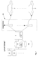
- Fig. 1 schematically a system according to the invention for the transmission of user-related data records 41 is shown.
- Each of these user-related data records has a location reference.
- This means that the data stored in the respective data record is related to a fixed location. This location is usually indicated by its geographic coordinates, such as latitude and longitude.
- any further information can be added to these data records 41, for example an information text, numbers or symbols which characterize the type of information.
- Such a user-related data record can relate, for example, to a traffic event, such as an accident or traffic jam.
- information relating to certain services in particular those in the vicinity of the respective position of the relevant vehicle, for advertising purposes to the relevant vehicle 2 are transmitted.
- a provider server 31 Each of the provider server 31 is, for example via LAN or Internet, connected to a database server or a database 11, which stores the provided by the providers or their servers 31 general data sets 40 and provides for a general query.
- This database 11 is connected to a server 1, wherein this server can access the data stored in the database 11.
- the general data records 40 stored in the database 11 are subdivided into different classes 49 or are subdivided.
- Such a subdivision into classes 49 can either be based on factual aspects, such as the separation of traffic data and advertising, or also to facilitate billing for providers.
- the data of one of the providers are generally stored in a different class 49 than the data of another provider.
- a user database 14 is set up.
- this user database 14 an association between users or terminal devices 21 used by them and the classes 49 of data records 40 intended for the respective terminal device 21 or the associated user is stored.
- a user identification may be provided before a user receives access to the data records 40 by means of his terminal device 21.
- the respective terminal device 21 receives the user-related data records 40 continuously.
- Particularly advantageous is an identification of users, if for the transmission of records 40 to the individual user a fee is payable.
- the user database 14 thus contains information about which classes 49 of data records 40 can be called up by which user or by which terminal device 21.
- the distribution of the data sets 40 to the individual terminal devices 21 takes place by means of a server 1 which is connected to a mobile radio network 15. If it is to be possible to receive data sets 40 from a vehicle 2, a display unit 23 and the terminal device 21 in the vehicle must be provided or arranged. In the vehicle 2, a display unit 23 is mounted, which represents user-related data records 41 received by radio radio signals.
- This in Fig. 2 shown terminal device 21 communicates with the mobile network 15 in connection and also has an additional transmitting antenna 24 for the delivery of radio radio signals, in particular an FM signal, on.
- user-related data sets 41 which have been transmitted from the server 1 by means of the mobile radio network 15 to the individual terminal devices 21, are transformed and radiated as a radio-radio signal and decoded and displayed via the display unit 23, which has an associated receiving unit .
- Commercially available GPS devices have such functionality.
- a range between 87.5 MHz and 108 MHz is selected for the frequency of the radiated radio radio signal.
- the transmission power of the transmitting antenna 24 arranged in the terminal device 21 is adjusted to a value below 10 mW.
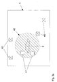
- the invention is based on the idea that in the presence of location-related data records 40, only those data sets for a user located in a vehicle 2 are important, which are related to a location in the immediate vicinity or within an environment 42 about the determined position of the vehicle 2 or whose location reference lies within this environment 2.
- the geographical position or position of the vehicle 2 is determined and a map, in particular a road map, shown in the area of the vehicle 2.
- a map in particular a road map, shown in the area of the vehicle 2.
- only one environment 42 of the vehicle 2 is always displayed on the display unit 23, while the remaining parts of the map are not displayed.
- it is sufficient for the representation and transmission of those data sets which have their location reference within a given environment 2 around the vehicle 2.
- the transmission of all user-subscribed or available data requires extremely high data rates and is very expensive for a large number of users and requires high bandwidths of the mobile radio network 15.
- the geographical position or position of the vehicle 2 is determined and, in particular by means of the mobile radio network 15, is transmitted to the server 1.
- the server 1 selects the user-related data records 41 relevant to the individual user. These user-related data records are transmitted via the mobile radio network 15 transmitted to the terminal device 21.
- Fig. 3a shows a possibility, with knowledge of the current position of the vehicle 2, for example, determined by a located in the terminal device 21 GPS device to determine an environment 42.
- a predetermined radius around the vehicle 2 is determined as the environment 42 of the vehicle 2.
- All data sets 40 which refer to this environment 42 or lie without reference to location within this environment 42 are referred to as user-related data records 41.
- Other records 40, as shown on the card 4, which are stored in the database 11 and may even be in one of the user-subscribed classes 49, are not displayed due to the environmental criteria.
- Fig. 3b Another option is as in Fig. 3b shown to bring only those records 41 to display, which relate to the catchment area of those mobile radio cell 43, within which also the vehicle 2 is located. Message 40, which is outside the mobile radio cell 43, are not transmitted to the vehicle 2, and therefore not displayed in this.
- FIG. 3c A variation of the in Fig. 3b Environmental criterion shown is in Fig. 3c described.
- the environment 42 of the vehicle 2 is also the amount of those mobile radio cells of the mobile radio network 15 which are adjacent to the mobile radio cell 43 in which the vehicle 2 is located (43 ").
Landscapes
- Engineering & Computer Science (AREA)
- Signal Processing (AREA)
- Computer Networks & Wireless Communication (AREA)
- Radar, Positioning & Navigation (AREA)
- General Physics & Mathematics (AREA)
- Physics & Mathematics (AREA)
- Remote Sensing (AREA)
- Atmospheric Sciences (AREA)
- Life Sciences & Earth Sciences (AREA)
- Environmental Sciences (AREA)
- Environmental & Geological Engineering (AREA)
- Ecology (AREA)
- Automation & Control Theory (AREA)
- Biodiversity & Conservation Biology (AREA)
- Traffic Control Systems (AREA)
- Mobile Radio Communication Systems (AREA)
Applications Claiming Priority (1)
| Application Number | Priority Date | Filing Date | Title |
|---|---|---|---|
| ATA1114/2008A AT507237B1 (de) | 2008-07-17 | 2008-07-17 | Verfahren zur personalisierung von tmc diensten |
Publications (1)
| Publication Number | Publication Date |
|---|---|
| EP2146525A1 true EP2146525A1 (fr) | 2010-01-20 |
Family
ID=41278184
Family Applications (1)
| Application Number | Title | Priority Date | Filing Date |
|---|---|---|---|
| EP09450131A Withdrawn EP2146525A1 (fr) | 2008-07-17 | 2009-07-16 | Procédé de personnalisation de services TMC |
Country Status (2)
| Country | Link |
|---|---|
| EP (1) | EP2146525A1 (fr) |
| AT (1) | AT507237B1 (fr) |
Citations (4)
| Publication number | Priority date | Publication date | Assignee | Title |
|---|---|---|---|---|
| EP1004852A2 (fr) * | 1998-11-19 | 2000-05-31 | Navigation Technologies Corporation | Méthode et système pour utiliser des informations de circulation radiodiffusées en temps réel avec des systèmes de navigation |
| DE10026918A1 (de) * | 1999-06-19 | 2000-12-28 | Ibm | Virtueller Netzwerkadapter |
| US20010029425A1 (en) * | 2000-03-17 | 2001-10-11 | David Myr | Real time vehicle guidance and traffic forecasting system |
| US20080057888A1 (en) * | 2006-08-31 | 2008-03-06 | Garmin Ltd. | System and method for selecting a frequency for personal-use fm transmission |
Family Cites Families (3)
| Publication number | Priority date | Publication date | Assignee | Title |
|---|---|---|---|---|
| DE19629233C2 (de) * | 1996-07-22 | 2003-08-07 | T Mobile Deutschland Gmbh | Verfahren zur Auswahl und Filterung von Verkehrsinformationen |
| KR100319294B1 (ko) * | 1998-09-14 | 2002-04-22 | 윤종용 | 쌍방향정보송/수신시스템및그서비스방법 |
| DE60213569T2 (de) * | 2002-06-05 | 2006-11-30 | Alcatel | Freisprechkommunikationssystem für Mobiltelefon wie auch ein Mobiltelefon und ein Audiosystem dafür |
-
2008
- 2008-07-17 AT ATA1114/2008A patent/AT507237B1/de not_active IP Right Cessation
-
2009
- 2009-07-16 EP EP09450131A patent/EP2146525A1/fr not_active Withdrawn
Patent Citations (4)
| Publication number | Priority date | Publication date | Assignee | Title |
|---|---|---|---|---|
| EP1004852A2 (fr) * | 1998-11-19 | 2000-05-31 | Navigation Technologies Corporation | Méthode et système pour utiliser des informations de circulation radiodiffusées en temps réel avec des systèmes de navigation |
| DE10026918A1 (de) * | 1999-06-19 | 2000-12-28 | Ibm | Virtueller Netzwerkadapter |
| US20010029425A1 (en) * | 2000-03-17 | 2001-10-11 | David Myr | Real time vehicle guidance and traffic forecasting system |
| US20080057888A1 (en) * | 2006-08-31 | 2008-03-06 | Garmin Ltd. | System and method for selecting a frequency for personal-use fm transmission |
Also Published As
| Publication number | Publication date |
|---|---|
| AT507237B1 (de) | 2017-10-15 |
| AT507237A1 (de) | 2010-03-15 |
Similar Documents
| Publication | Publication Date | Title |
|---|---|---|
| DE112006001993B4 (de) | System und Verfahren zum Bilden von Clustern aus Sondenfahrzeugen in einer Echtzeit-Verkehrsanwendung | |
| EP1079353B1 (fr) | Méthode pour demander et traiter des messages routiers | |
| EP0769180B1 (fr) | Dispositif pour preparer et fournir des informations destinees au conducteur d'un vehicule | |
| DE102010012400B4 (de) | Verfahren und System zum Austauschen von Informationen, die E85-Tankstellen betreffen, zwischen E85-Fahrzeugen | |
| DE69611274T3 (de) | System zur Schätzung und Übermittlung von Verkehrsinformationen | |
| DE69021900T2 (de) | Mobiles Navigationssystem. | |
| DE60130589T2 (de) | Telematikanwendung zum Implementieren in Verbindung mit einem Satelliten Rundfunk Ablieferungssystem | |
| DE19604084A1 (de) | Verfahren und Einrichtung zur Ermittlung von Dynamischen Verkehrsinformationen | |
| EP2756491A1 (fr) | Procédé et dispositif de détermination d'une recommandation de conduite pour un véhicule ainsi que procédé et dispositif pour produire une recommandation de conduite pour un véhicule | |
| EP2500869B1 (fr) | Procédé de mise à disposition de services de données en fonction du lieu | |
| DE102007048910B4 (de) | Programmierbares dynamisches routenspezifisches Verkehrswarnsystem | |
| EP1921588A2 (fr) | Système de détection de trafic | |
| AT507237B1 (de) | Verfahren zur personalisierung von tmc diensten | |
| EP1307868B1 (fr) | Procede de transmission du trajet et de la position d'un vehicule de services d'urgence a des vehicules automobiles | |
| DE10011702A1 (de) | Verfahren zur standortbezogenen Information von Verkehrsteilnehmern | |
| DE60221262T2 (de) | Positionsbestimmungssystem und -verfahren eines drahtlosen Kommunikationsgerätes | |
| DE102008000002A1 (de) | Positionsabhängiges Werbe- und Verkehrswarnsystem | |
| DE69833679T2 (de) | Verfahren zur verwendung von speichern zur fahrzeugnavigationshilfe | |
| DE102019004766B4 (de) | Verfahren, mobile Empfangseinrichtung und Server zum Aktualisieren einer Netzabdeckungskarte | |
| DE102011005552B4 (de) | Verfahren für einen Datenaustausch von Navigationsnutzern von Kraftfahrzeugen sowie System zum Datenaustausch | |
| DE29505615U1 (de) | Verkehrsleitsystem für ein Verkehrswegenetz | |
| DE69708131T2 (de) | Verfahren zur lokalisierung eines notrufs | |
| DE102006003702B3 (de) | Globales Informations- und Risikowarnsystem unter Verwendung von Satellitennavigationssystemen und Benutzerendgeräten | |
| EP0836292B1 (fr) | Méthode et dispositif pour la présentation sélective, selon la région ou se trouve le récepteur, de messages codés numériques radiodiffusés | |
| DE102005061419B4 (de) | Verfahren zum Übertragen von verkehrsrelevanten Informationen |
Legal Events
| Date | Code | Title | Description |
|---|---|---|---|
| PUAI | Public reference made under article 153(3) epc to a published international application that has entered the european phase |
Free format text: ORIGINAL CODE: 0009012 |
|
| AK | Designated contracting states |
Kind code of ref document: A1 Designated state(s): AT BE BG CH CY CZ DE DK EE ES FI FR GB GR HR HU IE IS IT LI LT LU LV MC MK MT NL NO PL PT RO SE SI SK SM TR |
|
| AX | Request for extension of the european patent |
Extension state: AL BA RS |
|
| 17P | Request for examination filed |
Effective date: 20100705 |
|
| 17Q | First examination report despatched |
Effective date: 20100730 |
|
| GRAP | Despatch of communication of intention to grant a patent |
Free format text: ORIGINAL CODE: EPIDOSNIGR1 |
|
| RIC1 | Information provided on ipc code assigned before grant |
Ipc: H04W 4/02 20090101ALI20130513BHEP Ipc: H04W 4/04 20090101AFI20130513BHEP Ipc: H04W 4/18 20090101ALN20130513BHEP |
|
| INTG | Intention to grant announced |
Effective date: 20130613 |
|
| STAA | Information on the status of an ep patent application or granted ep patent |
Free format text: STATUS: THE APPLICATION IS DEEMED TO BE WITHDRAWN |
|
| 18D | Application deemed to be withdrawn |
Effective date: 20131126 |