EP2706380A2 - Système et procédé pour localiser un récepteur de signal satellite - Google Patents
Système et procédé pour localiser un récepteur de signal satellite Download PDFInfo
- Publication number
- EP2706380A2 EP2706380A2 EP13180693.7A EP13180693A EP2706380A2 EP 2706380 A2 EP2706380 A2 EP 2706380A2 EP 13180693 A EP13180693 A EP 13180693A EP 2706380 A2 EP2706380 A2 EP 2706380A2
- Authority
- EP
- European Patent Office
- Prior art keywords
- satellite
- channels
- ephemeris
- predetermined number
- capturing
- Prior art date
- Legal status (The legal status is an assumption and is not a legal conclusion. Google has not performed a legal analysis and makes no representation as to the accuracy of the status listed.)
- Withdrawn
Links
- 238000000034 method Methods 0.000 title claims abstract description 32
- 238000010586 diagram Methods 0.000 description 10
- 238000004891 communication Methods 0.000 description 3
- 238000012986 modification Methods 0.000 description 3
- 230000004048 modification Effects 0.000 description 3
- 238000007792 addition Methods 0.000 description 1
- 239000013078 crystal Substances 0.000 description 1
- -1 elements Substances 0.000 description 1
- 238000004519 manufacturing process Methods 0.000 description 1
- 239000000463 material Substances 0.000 description 1
- 238000006467 substitution reaction Methods 0.000 description 1
Images


Classifications
-
- G—PHYSICS
- G01—MEASURING; TESTING
- G01S—RADIO DIRECTION-FINDING; RADIO NAVIGATION; DETERMINING DISTANCE OR VELOCITY BY USE OF RADIO WAVES; LOCATING OR PRESENCE-DETECTING BY USE OF THE REFLECTION OR RERADIATION OF RADIO WAVES; ANALOGOUS ARRANGEMENTS USING OTHER WAVES
- G01S19/00—Satellite radio beacon positioning systems; Determining position, velocity or attitude using signals transmitted by such systems
- G01S19/01—Satellite radio beacon positioning systems transmitting time-stamped messages, e.g. GPS [Global Positioning System], GLONASS [Global Orbiting Navigation Satellite System] or GALILEO
- G01S19/13—Receivers
- G01S19/24—Acquisition or tracking or demodulation of signals transmitted by the system
- G01S19/28—Satellite selection
-
- G—PHYSICS
- G01—MEASURING; TESTING
- G01S—RADIO DIRECTION-FINDING; RADIO NAVIGATION; DETERMINING DISTANCE OR VELOCITY BY USE OF RADIO WAVES; LOCATING OR PRESENCE-DETECTING BY USE OF THE REFLECTION OR RERADIATION OF RADIO WAVES; ANALOGOUS ARRANGEMENTS USING OTHER WAVES
- G01S19/00—Satellite radio beacon positioning systems; Determining position, velocity or attitude using signals transmitted by such systems
- G01S19/01—Satellite radio beacon positioning systems transmitting time-stamped messages, e.g. GPS [Global Positioning System], GLONASS [Global Orbiting Navigation Satellite System] or GALILEO
- G01S19/13—Receivers
- G01S19/34—Power consumption
-
- G—PHYSICS
- G01—MEASURING; TESTING
- G01S—RADIO DIRECTION-FINDING; RADIO NAVIGATION; DETERMINING DISTANCE OR VELOCITY BY USE OF RADIO WAVES; LOCATING OR PRESENCE-DETECTING BY USE OF THE REFLECTION OR RERADIATION OF RADIO WAVES; ANALOGOUS ARRANGEMENTS USING OTHER WAVES
- G01S19/00—Satellite radio beacon positioning systems; Determining position, velocity or attitude using signals transmitted by such systems
- G01S19/01—Satellite radio beacon positioning systems transmitting time-stamped messages, e.g. GPS [Global Positioning System], GLONASS [Global Orbiting Navigation Satellite System] or GALILEO
- G01S19/13—Receivers
- G01S19/35—Constructional details or hardware or software details of the signal processing chain
- G01S19/37—Hardware or software details of the signal processing chain
Definitions
- a conventional satellite navigation system e.g., Global Positioning System or BeiDou Satellite Navigation System (hereinafter "BeiDou"), usually opens all channels corresponding to the number of satellites the system is able to simultaneously monitor, to capture, track and demodulate satellite signals/data after turning on a corresponding satellite signal receiver, so as to obtain an accurate position/location of the corresponding satellite signal receiver.
- BeiDou BeiDou Satellite Navigation System
- a system for locating a satellite signal receiver includes a channel opening module, a signal processing module, and a positioning module.
- the channel opening module is configured for opening a predetermined number of channels based on a priority schedule.
- the signal processing module is configured for capturing and tracking satellite signals via the opened channels, and demodulating the tracked satellite signals to obtain corresponding satellite data.
- the positioning module is configured for determining a position of the satellite signal receiver based on the satellite data.
- a method for locating a satellite signal receiver is disclosed.
- a predetermined number of channels is opened based on a priority schedule.
- Satellite signals are captured and tracked via the opened channels.
- the tracked satellite signals are demodulated for obtaining corresponding satellite data.
- a position of the satellite signal receiver is determined based on the satellite data.
- FIG. 1 illustrates a block diagram of an example of a satellite signal receiver, in accordance with an embodiment of the present teaching
- FIG. 2 illustrates a block diagram of an example of a satellite signal receiver, in accordance with another embodiment of the present teaching
- FIG. 3 illustrates a block diagram of an example of a satellite signal receiver, in accordance with yet another embodiment of the present teaching
- FIG. 4 illustrates a block diagram of an example of a satellite signal receiver, in accordance with yet another embodiment of the present teaching
- FIG. 5 illustrates a block diagram of an example of a satellite signal receiver, in accordance with yet another embodiment of the present teaching
- FIG. 6 illustrates a flowchart of an exemplary method for locating a satellite signal receiver, in accordance with an embodiment of the present teaching
- FIG. 7 illustrates a flowchart of an exemplary method for locating a satellite signal receiver, in accordance with another embodiment of the present teaching.
- FIG. 8 illustrates a flowchart of an exemplary method for locating a satellite signal receiver, in accordance with yet another embodiment of the present teaching.
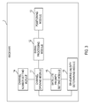
- FIG. 1 illustrates a block diagram of an example of a satellite signal receiver 1, in accordance with an embodiment of the present teaching.
- a satellite signal receiver 1 includes a channel opening module 11, a signal processing module 12, and a positioning module 13.
- the channel opening module 11 of this embodiment is configured for opening a predetermined number of channels based on a preset priority schedule indicating priorities of satellites.
- the predetermined number is less than the total number of available channels in the satellite signal receiver 1.
- the total number can be twelve, and the predetermined number can be one, four, or six, etc.
- the signal processing module 12 in this embodiment is configured for capturing and tracking satellite signals via the opened channels, demodulating the tracked satellite signals for obtaining corresponding satellite data carried by the tracked satellite signals, and downloading corresponding satellite data.
- the positioning module13 in this embodiment is configured for determining a current position/location of the satellite signal receiver 1 based on the downloaded satellite data.
- the navigation system in the receiver opens all the channels to capture and track satellite signals, and demodulates an ephemeris, so as to locate the receiver as soon as possible.
- a navigation system can obtain a positioning accuracy by tracking the channels.
- opening all channels for positioning can cause relatively high power consumption. Therefore, after turning on the receiver, the navigation system can effectively reduce the power consumption by opening as few channels as possible to capture and track the satellite signals.
- the receiver needs at least four satellites for positioning and the receiver in such an embodiment needs to open four or more channels for positioning to occur. If a higher positioning accuracy is required, the number of the opened channels can be increased, e.g., to six channels.
- the receiver 1 may utilize the channel opening module 11 to open a corresponding number of channels based on a requirement on positioning accuracy of the receiver, so as to capture and track the satellite signals. The receiver 1 can effectively reduce power consumption for positioning.
- FIG. 2 illustrates a block diagram of an example of a satellite signal receiver 1, in accordance with another embodiment of the present teaching.
- the satellite signal receiver 1 in the example of FIG. 2 further includes a channel number setting module 14 and a satellite priority setting module 15.
- the channel number setting module14 is configured for setting the predetermined number of channels that are used to capture and track satellite signals, based on a requirement on positioning accuracy of the satellite signal receiver 1. The higher the requirement on the positioning accuracy is, the more channels can be opened. In other words, if the requirement on the positioning accuracy increases, the channel number setting module14 increases the predetermined number accordingly. Additionally, the satellite priority setting module 15 sets the priority schedule based on an ephemeris stored in the receiver 1 and/or based on types of the satellites. For example, a satellite whose signal is captured more easily (hereinafter, an "easily captured satellite”) can have a higher priority.
- a first satellite has a higher priority than a second satellite if the satellite priority setting module 15 determines that a signal from the first satellite can be captured more easily than a signal from the second satellite.
- the channel opening module 11 can open a channel corresponding to the easily captured satellite.
- the satellite priority setting module 15 can obtain the information regarding which satellite is currently available based on the ephemeris in the receiver 1, and can organize the available satellites in a star search queue according to degrees of difficulty for capturing the signals from the available satellites. In one embodiment, the satellite priority setting module 15 can also adjust the order of the satellites in the star search queue according to the types of the satellites, e.g., by adjusting the schedule of priorities of the satellites in the star search queue. In one example, regarding the BeiDou (BeiDou Satellite Navigation System) receiver, a GEO (Geostationary Earth Orbit) satellite can be among the first satellites selected when the GEO satellite is set with a higher priority.
- BeiDou BeiDou Satellite Navigation System
- the GEO satellite is a geosynchronous satellite, and the signal from the GEO satellite is likely to be successfully captured if a temperature compensated crystal oscillator (TCCO) in the receiver 1 does not have a large offset or a large frequency error when the ephemeris in the receiver 1 is valid.
- TCCO temperature compensated crystal oscillator
- the MEO (Middle Earth Orbit) satellite may be selected after the GEO satellite.
- FIG. 3 illustrates a block diagram of an example of a satellite signal receiver 1, in accordance with yet another embodiment of the present teaching.
- the receiver 1 in the example of FIG. 3 further includes an ephemeris validity determining module 16.
- the ephemeris validity determining module 16 is configured for determining whether the ephemeris in the receiver 1 is valid. If the ephemeris validity determining module 16 determines that the ephemeris is valid, the satellite priority setting module 15 can perform calculation based on the valid ephemeris to determine/find current visible satellites, and the channel opening module 11 can open the predetermined number of channels corresponding to the satellites having higher priorities based on the priority schedule of satellites set by the satellite priority setting module 15.
- the satellite priority setting module 15 can ignore the ephemeris and the corresponding priority schedule, and search for available/visible satellites by receiving signals from all possible satellites successively, e.g., one by one starting from the first satellite.
- the channel opening module 11 opens a set of channels with a total number greater than or equal to the above mentioned predetermined number. In other words, the number of the opened channels is equal to or greater than the predetermined number.
- the channel opening module 11 if the channel opening module 11 opens the predetermined number of channels to capture and track the satellite signals, power consumption for the positioning can be controlled such that the level of power consumption is roughly the same as that in a situation when the ephemeris is valid. However, the time for positioning may be longer because signals from some satellites are difficult to be captured. Therefore, the channels opening module 11 can increase the number of the channels to be opened to reduce the time for positioning, so as to achieve a balance among positioning speed, positioning accuracy, and power consumption.
- FIG. 4 illustrates a block diagram of an example of a satellite signal receiver 1, in accordance with yet another embodiment of the present teaching.
- the signal processing module 12 of the receiver 1, in the example of FIG. 4 includes a capturing unit 121, a tracking unit 122, and a demodulating unit 123.
- the capturing unit 121 in this embodiment is configured for capturing satellite signals via the channels opened by the channel opening module 11.
- the tracking unit 22 in this embodiment is configured for tracking the satellite signals received by the capturing unit 121.
- the demodulating unit 123 in this embodiment is configured for demodulating the satellite signals tracked by the tracking unit 123 and downloading the corresponding satellite data, such that the positioning module 13 can calculate a current position of the receiver 1 based on the downloaded satellite data.
- FIG. 5 illustrates a block diagram of an example of a satellite signal receiver 1, in accordance with yet another embodiment of the present teaching.
- the receiver 1 in the example of FIG. 5 further includes a channel number determining module 17.
- the receiver 1 can track a satellite signal captured via an opened channel. In other words, an opened channel becomes an occupied channel for tracking the satellite signal. If the tracked satellite signal is weak or lost, the occupied channel can be vacated for awaiting a next satellite signal.
- the channel number determining module 17 determines whether the number of the channels occupied for tracking satellite signals reaches the above mentioned predetermined number. If the channel number determining module 17 determines that the number of the occupied channels reaches the predetermined number, the capturing unit 121 ceases capturing satellite signals via an opened channel. As mentioned before, if a tracked satellite signal is weak or lost, a corresponding occupied channel may be vacated, and the number of the occupied channels may decrease. If the number of the occupied channels is less than the predetermined number, in other words there is one or more spare channels for tracking satellite signals, the capturing unit 121 restarts capturing satellite signals.
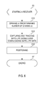
- FIG. 6 illustrates a flowchart of an exemplary method for locating a satellite signal receiver, in accordance with an embodiment of the present teaching.
- the exemplary method may be implemented on a machine having at least one processor, storage, and a communication platform.
- the present teaching is well suited for performing various variations of the method in FIG. 6 .
- a predetermined number of channels are opened based on a preset priority schedule of satellites.
- a satellite signal is captured and tracked via an opened channel, the tracked satellite signal is demodulated, and corresponding satellite data is downloaded.
- a current position of the satellite signal receiver is determined based on the corresponding satellite data. The positioning process is terminated at SE.
- the satellite signal receiver sets the predetermined number of channels based on a requirement on positioning accuracy of the receiver, such that the predetermined number increases if the requirement increases, e.g., the higher the requirement on the positioning accuracy is, the more the opened channels can be.
- FIG. 7 illustrates a flowchart of an exemplary method for locating a satellite signal receiver, in accordance with another embodiment of the present teaching.
- the exemplary method may be implemented on a machine having at least one processor, storage, and a communication platform.
- the present teaching is well suited for performing various variations of the method in FIG. 7 .
- the receiver also performs an operation that determines whether an ephemeris stored in the receiver is valid, and an operation that sets a priority schedule of satellites based on the ephemeris and/or the types of the satellites, so as to open a channel corresponding to an above mentioned easily captured satellite.
- the process moves to S11 after the receiver starts at SS.
- the receiver determines whether the ephemeris in the receiver is valid. On one hand, if the ephemeris is valid, the receiver can determine which satellites are available/visible currently based on the ephemeris in the receiver, so as to set, at S12, a priority schedule of satellites, e.g., based on the ephemeris and /or the types of the satellites. In the priority schedule, a satellite whose signal can be captured more easily has a higher priority.
- the receiver opens a predetermined number of channels corresponding to the satellites having higher priority in the priority schedule.
- the process moves to S13.
- the receiver ignores the ephemeris and the corresponding priority schedule, and searches for available/visible satellites by receiving signals from all possible satellites one by one.
- the receiver opens a set of channels to capture and track the satellite signals, and the number of the opened channels is equal to or greater than the above mentioned predetermined number.
- FIG. 8 illustrates a flowchart of an exemplary method for locating a satellite signal receiver, in accordance with yet another embodiment of the present teaching.
- the exemplary method may be implemented on a machine having at least one processor, storage, and a communication platform.
- the present teaching is well suited for performing various variations of the method in FIG. 8 .
- the S20 previously disclosed in FIG. 6 further includes a capturing operation S21 to capture satellite signals via the channels opened at S10; a tracking operation S22 to track the captured satellite signals; and a demodulating operation S23 to demodulate the tracked satellite signals and download corresponding satellite data.
- the S20 disclosed in FIG. 6 further includes an operation S24 to determine whether the number of channels occupied for tracking satellite signals reaches the predetermined number during a tracking process, e.g., determines whether the opened channels are full. If the opened channels are full, the process moves to S25, in which the receiver pauses capturing satellite signals until the number of the occupied channels becomes less than the predetermined number, e.g., there is a spare opened channel. If a spare opened channel exists, the process moves to S21 to capture and track satellite signals again.
- the present teaching can be applied not only in a dual-mode receiver but also in a single-mode receiver.
- the embodiments according to the present teaching can be applied receivers such as GPS receivers, BeiDou receivers, Glonass receivers, and Galileo receivers.
Landscapes
- Engineering & Computer Science (AREA)
- Radar, Positioning & Navigation (AREA)
- Remote Sensing (AREA)
- Computer Networks & Wireless Communication (AREA)
- Physics & Mathematics (AREA)
- General Physics & Mathematics (AREA)
- Signal Processing (AREA)
- Position Fixing By Use Of Radio Waves (AREA)
- Radio Relay Systems (AREA)
Applications Claiming Priority (2)
| Application Number | Priority Date | Filing Date | Title |
|---|---|---|---|
| CN201210325759.8A CN103675840A (zh) | 2012-09-05 | 2012-09-05 | 卫星信号接收机及其定位方法 |
| US13/964,187 US20140062769A1 (en) | 2012-09-05 | 2013-08-12 | System and Method for Locating a Satellite Signal Receiver |
Publications (2)
| Publication Number | Publication Date |
|---|---|
| EP2706380A2 true EP2706380A2 (fr) | 2014-03-12 |
| EP2706380A3 EP2706380A3 (fr) | 2015-01-07 |
Family
ID=49028898
Family Applications (1)
| Application Number | Title | Priority Date | Filing Date |
|---|---|---|---|
| EP13180693.7A Withdrawn EP2706380A3 (fr) | 2012-09-05 | 2013-08-16 | Système et procédé pour localiser un récepteur de signal satellite |
Country Status (1)
| Country | Link |
|---|---|
| EP (1) | EP2706380A3 (fr) |
Cited By (4)
| Publication number | Priority date | Publication date | Assignee | Title |
|---|---|---|---|---|
| CN106291614A (zh) * | 2015-06-24 | 2017-01-04 | 法国国家太空研究中心 | 用于在多路径环境中跟踪卫星无线电导航信号的装置 |
| CN106291625A (zh) * | 2015-06-24 | 2017-01-04 | 法国国家太空研究中心 | 具有改进的用于解算子载波跟踪模糊度的能力的gnss接收机 |
| CN111045038A (zh) * | 2019-12-27 | 2020-04-21 | 中国科学院国家空间科学中心 | 一种gnss-r接收机反射通道数量的优化方法 |
| CN112526552A (zh) * | 2020-11-25 | 2021-03-19 | 南京九度卫星科技研究院有限公司 | 北斗海上救生定位集成系统 |
Family Cites Families (2)
| Publication number | Priority date | Publication date | Assignee | Title |
|---|---|---|---|---|
| JPH03146890A (ja) * | 1989-11-02 | 1991-06-21 | Pioneer Electron Corp | Gps受信機の衛星電波捕捉方式 |
| JP3104132B2 (ja) * | 1999-03-23 | 2000-10-30 | ソニー株式会社 | 測位信号受信機 |
-
2013
- 2013-08-16 EP EP13180693.7A patent/EP2706380A3/fr not_active Withdrawn
Non-Patent Citations (1)
| Title |
|---|
| None |
Cited By (6)
| Publication number | Priority date | Publication date | Assignee | Title |
|---|---|---|---|---|
| CN106291614A (zh) * | 2015-06-24 | 2017-01-04 | 法国国家太空研究中心 | 用于在多路径环境中跟踪卫星无线电导航信号的装置 |
| CN106291625A (zh) * | 2015-06-24 | 2017-01-04 | 法国国家太空研究中心 | 具有改进的用于解算子载波跟踪模糊度的能力的gnss接收机 |
| CN106291625B (zh) * | 2015-06-24 | 2019-04-23 | 法国国家太空研究中心 | 具有改进的用于解算子载波跟踪模糊度的能力的gnss接收机 |
| CN106291614B (zh) * | 2015-06-24 | 2019-09-03 | 法国国家太空研究中心 | 用于在多路径环境中跟踪卫星无线电导航信号的装置 |
| CN111045038A (zh) * | 2019-12-27 | 2020-04-21 | 中国科学院国家空间科学中心 | 一种gnss-r接收机反射通道数量的优化方法 |
| CN112526552A (zh) * | 2020-11-25 | 2021-03-19 | 南京九度卫星科技研究院有限公司 | 北斗海上救生定位集成系统 |
Also Published As
| Publication number | Publication date |
|---|---|
| EP2706380A3 (fr) | 2015-01-07 |
Similar Documents
| Publication | Publication Date | Title |
|---|---|---|
| US20140062769A1 (en) | System and Method for Locating a Satellite Signal Receiver | |
| US8185134B2 (en) | Multimode GPS-enabled camera | |
| EP2634600B1 (fr) | Procédés et appareils pour utilisation avec une radio de navigation à commutation | |
| US20140062770A1 (en) | Satellite Signal Receiver and Method for Updating Ephemeris Information Thereby | |
| US20100253578A1 (en) | Navigation data acquisition and signal post-processing | |
| EP2442138A1 (fr) | Procédé et système de réduction de la durée autonome pour fixer un récepteur GNSS multi-standard | |
| EP1842078A1 (fr) | Indication d'emplacement par post-traitement | |
| JP5663619B2 (ja) | ナビゲーションビット境界決定装置、およびその方法 | |
| EP2235556A1 (fr) | Procédé gnss et récepteur avec assistance par caméra | |
| US20120022779A1 (en) | Navigation receivers | |
| JP2013213818A (ja) | ナビゲーションビット境界決定装置、およびそのための方法 | |
| EP2706380A2 (fr) | Système et procédé pour localiser un récepteur de signal satellite | |
| JP4613334B2 (ja) | 衛星航法システムにおける衛星軌道情報の伝送方法及びそれらの装置 | |
| WO2014083745A1 (fr) | Procédé de commande pour dispositif de calcul de position et dispositif de calcul de position | |
| US10254410B2 (en) | Positioning control method, positioning device and storage medium | |
| JPH03293576A (ja) | Gps受信機の衛星電波捕促方式 | |
| EP2277059B1 (fr) | Appareil pour aider à fournir un premier point de repère dans un système satellite de positionnement global, appareil et procédés associés | |
| JP5078352B2 (ja) | 部分的アルマナック収集システム | |
| JP6152663B2 (ja) | 位置算出装置の制御方法及び位置算出装置 | |
| EP2706381A1 (fr) | Récepteur de signaux satellites et procédé de mise à jour d'informations d'éphéméride associé | |
| JP5901177B2 (ja) | 測位装置、観測装置および測位方法 | |
| GB2482474A (en) | Reduce interference in GPS enabled multifunctional devices |
Legal Events
| Date | Code | Title | Description |
|---|---|---|---|
| PUAI | Public reference made under article 153(3) epc to a published international application that has entered the european phase |
Free format text: ORIGINAL CODE: 0009012 |
|
| AK | Designated contracting states |
Kind code of ref document: A2 Designated state(s): AL AT BE BG CH CY CZ DE DK EE ES FI FR GB GR HR HU IE IS IT LI LT LU LV MC MK MT NL NO PL PT RO RS SE SI SK SM TR |
|
| AX | Request for extension of the european patent |
Extension state: BA ME |
|
| RIC1 | Information provided on ipc code assigned before grant |
Ipc: G01S 19/24 20100101AFI20140826BHEP Ipc: G01S 19/34 20100101ALI20140826BHEP Ipc: G01S 19/28 20100101ALI20140826BHEP Ipc: G01S 19/37 20100101ALI20140826BHEP |
|
| PUAL | Search report despatched |
Free format text: ORIGINAL CODE: 0009013 |
|
| AK | Designated contracting states |
Kind code of ref document: A3 Designated state(s): AL AT BE BG CH CY CZ DE DK EE ES FI FR GB GR HR HU IE IS IT LI LT LU LV MC MK MT NL NO PL PT RO RS SE SI SK SM TR |
|
| AX | Request for extension of the european patent |
Extension state: BA ME |
|
| RIC1 | Information provided on ipc code assigned before grant |
Ipc: G01S 19/37 20100101ALI20141203BHEP Ipc: G01S 19/34 20100101ALI20141203BHEP Ipc: G01S 19/24 20100101AFI20141203BHEP Ipc: G01S 19/28 20100101ALI20141203BHEP |
|
| STAA | Information on the status of an ep patent application or granted ep patent |
Free format text: STATUS: THE APPLICATION IS DEEMED TO BE WITHDRAWN |
|
| 18D | Application deemed to be withdrawn |
Effective date: 20150708 |