EP3492828A1 - Verfahren und vorrichtung zum einstellen eines zeitprogramms eines heizsystems und/oder eines zeitprogramms eines systems zur hausautomation - Google Patents
Verfahren und vorrichtung zum einstellen eines zeitprogramms eines heizsystems und/oder eines zeitprogramms eines systems zur hausautomation Download PDFInfo
- Publication number
- EP3492828A1 EP3492828A1 EP18206978.1A EP18206978A EP3492828A1 EP 3492828 A1 EP3492828 A1 EP 3492828A1 EP 18206978 A EP18206978 A EP 18206978A EP 3492828 A1 EP3492828 A1 EP 3492828A1
- Authority
- EP
- European Patent Office
- Prior art keywords
- cell
- route
- location
- time
- historical
- Prior art date
- Legal status (The legal status is an assumption and is not a legal conclusion. Google has not performed a legal analysis and makes no representation as to the accuracy of the status listed.)
- Granted
Links
Images


Classifications
-
- G—PHYSICS
- G05—CONTROLLING; REGULATING
- G05B—CONTROL OR REGULATING SYSTEMS IN GENERAL; FUNCTIONAL ELEMENTS OF SUCH SYSTEMS; MONITORING OR TESTING ARRANGEMENTS FOR SUCH SYSTEMS OR ELEMENTS
- G05B15/00—Systems controlled by a computer
- G05B15/02—Systems controlled by a computer electric
-
- F—MECHANICAL ENGINEERING; LIGHTING; HEATING; WEAPONS; BLASTING
- F24—HEATING; RANGES; VENTILATING
- F24D—DOMESTIC- OR SPACE-HEATING SYSTEMS, e.g. CENTRAL HEATING SYSTEMS; DOMESTIC HOT-WATER SUPPLY SYSTEMS; ELEMENTS OR COMPONENTS THEREFOR
- F24D19/00—Details
- F24D19/10—Arrangement or mounting of control or safety devices
- F24D19/1006—Arrangement or mounting of control or safety devices for water heating systems
- F24D19/1009—Arrangement or mounting of control or safety devices for water heating systems for central heating
-
- F—MECHANICAL ENGINEERING; LIGHTING; HEATING; WEAPONS; BLASTING
- F24—HEATING; RANGES; VENTILATING
- F24D—DOMESTIC- OR SPACE-HEATING SYSTEMS, e.g. CENTRAL HEATING SYSTEMS; DOMESTIC HOT-WATER SUPPLY SYSTEMS; ELEMENTS OR COMPONENTS THEREFOR
- F24D19/00—Details
- F24D19/10—Arrangement or mounting of control or safety devices
- F24D19/1006—Arrangement or mounting of control or safety devices for water heating systems
- F24D19/1051—Arrangement or mounting of control or safety devices for water heating systems for domestic hot water
-
- F—MECHANICAL ENGINEERING; LIGHTING; HEATING; WEAPONS; BLASTING
- F24—HEATING; RANGES; VENTILATING
- F24D—DOMESTIC- OR SPACE-HEATING SYSTEMS, e.g. CENTRAL HEATING SYSTEMS; DOMESTIC HOT-WATER SUPPLY SYSTEMS; ELEMENTS OR COMPONENTS THEREFOR
- F24D19/00—Details
- F24D19/10—Arrangement or mounting of control or safety devices
- F24D19/1006—Arrangement or mounting of control or safety devices for water heating systems
- F24D19/1066—Arrangement or mounting of control or safety devices for water heating systems for the combination of central heating and domestic hot water
-
- G—PHYSICS
- G01—MEASURING; TESTING
- G01C—MEASURING DISTANCES, LEVELS OR BEARINGS; SURVEYING; NAVIGATION; GYROSCOPIC INSTRUMENTS; PHOTOGRAMMETRY OR VIDEOGRAMMETRY
- G01C21/00—Navigation; Navigational instruments not provided for in groups G01C1/00 - G01C19/00
- G01C21/20—Instruments for performing navigational calculations
-
- G—PHYSICS
- G05—CONTROLLING; REGULATING
- G05B—CONTROL OR REGULATING SYSTEMS IN GENERAL; FUNCTIONAL ELEMENTS OF SUCH SYSTEMS; MONITORING OR TESTING ARRANGEMENTS FOR SUCH SYSTEMS OR ELEMENTS
- G05B2219/00—Program-control systems
- G05B2219/20—Pc systems
- G05B2219/26—Pc applications
- G05B2219/2642—Domotique, domestic, home control, automation, smart house
Definitions
- the invention relates to a method for setting a time program of a heating system and / or a time program of a home automation system.
- the invention also relates to a computer program adapted to carry out an embodiment of the method according to the present invention, a machine-readable storage medium with a computer program according to the present invention and a mobile computing device with a computer program according to the present invention.
- Modern heating systems or systems for building automation make it possible to operate a heating of a dwelling depending on the presence of the resident.
- an apartment is preferably heated only when the occupant is present.
- the presence of the resident is detected when his smartphone has dialed into the home's WiFi network or a GPS receiver on the smartphone detects a location that is reasonably close to the home.
- Such presence-based controls have the disadvantage that the resident can arrive in a cold apartment, which is heated only after his arrival.
- the present invention describes a method for setting a time program of a heating system and / or a time program of a system for Home automation - for example, a smart home system - by a prediction of an arrival time and a destination depending on a previously traveled partial route, in particular by means of a mobile computing device.
- a time program of the heating system and a system for home automation is set.
- the time program can be set so that the heating system increases a room temperature on weekdays from a certain time, because at this time usually the residents come back from work. If the method predicts an arrival time lying before or after this time, the time program can be adapted accordingly; in particular, the time from which the heating system provides a higher room temperature can be changed to the determined arrival time.
- heating system is to be understood in particular as meaning a system comprising at least one device for generating heat energy and / or for receiving heat energy, in particular a heating device or heating burner, for example a condensing boiler, in particular for use in a building heating system and / or for hot water production by burning a gaseous or liquid fuel or by electric heating.
- a heating system can also consist of several such devices for generating thermal energy and other, the heating operation supporting devices, such as a water or fuel storage or a water or fuel pump or an expansion vessel consist.
- System for home automation or “smart home system” is to be understood in particular as a system for automatically or at least partially performing and / or controlling and / or regulating functional sequences in a building, in particular residential buildings, in particular according to predetermined setting parameters.
- a system for home automation includes the control and / or regulation of functional sequences of building security or building monitoring and / or energy management and / or Building heating and / or the hot water supply and / or lighting and / or household appliances and / or consumer electronics.
- a home automation system may include, for example, a heating system and / or a lighting system.
- the devices of a home automation system such as sensors, actuators, controls, consumers and other technical units, are networked together.
- a home automation system is often set up for communication or data exchange with a remote, preferably mobile computing device, for example via the Internet, in particular through a cloud.
- a remote preferably mobile computing device
- functional processes in the building can be remotely controlled, for example, a desired room temperature can be set.
- receive information from the building for example a recording of a surveillance camera or a measured room temperature.
- smart home system is sometimes meant a home automation system that focuses on intelligent control, such as self-learning algorithms.
- time program is meant in particular an adjustable flowchart of function and / or parameters of a heating system and / or a system for home automation.
- the heating system or the home automation system are operated as a function of the time program, so that the functions and / or parameters defined in the time program are carried out or accepted as far as possible at the specified times.
- the computing device may include a data memory, a computing unit and means for receiving and / or detecting location data or from a location coordinate and means for sending data to the heating system or to a system for home automation.
- the computer is preferred configured to predict at least the arrival time and destination depending on the partial route traveled so far, preferably to determine an expected route, wherein the expected route is a prediction of a further course of a previously traveled partial route. Examples of computing devices are PCs, smartphones, servers or room control units for heating systems and / or systems for home automation.
- a “mobile computing device” is a computing device, which is in particular intended to be portable by a user and to be used at different locations, preferably arbitrary locations. Examples of mobile computing units are smartphones, tablets, smart watches or notebooks.
- Prediction of the arrival time and the destination means, in particular, the determination of a most probable arrival time depending on available information and a most likely destination depending on available information.
- a “partial route” is a not yet completely covered route.
- the partial route describes a route from a starting location to a current location.
- a “route” describes the route from a starting point to a destination.
- a route is composed at least of location information which at least approximately describes the route.
- a route can be composed of discrete location coordinates, such as GPS coordinates, which lie along the way.
- the fact that the method can be carried out largely completely on a preferably mobile computing device of the user has the additional advantage that no personal location data and / or movement data have to be sent or passed on to carry out the method. This protects a user's privacy.
- the use of a geodetic network for determining the location cell has the advantage that no map data is necessary. No storage space is needed for map data. In particular, it is not necessary to receive card data on a mobile computing device, in particular a smartphone.
- Location coordinate should be understood as a currently determined location coordinate.
- the location coordinate describes the current location.
- a location coordinate may be a geographic coordinate, such as an indication of latitude and longitude.
- Geodetic network is to be understood as a subdivision of an entire earth surface or at least part of the earth surface into surface elements, wherein the surface elements largely completely cover the entire earth surface or the part of the earth surface.
- the surface elements Preferably, the surface elements have a regular structure, for example by a grid-shaped arrangement.
- the geodesic network is formed by a rectangular grid, for example by lines of constant latitude and lines of constant geographical height.
- An example of a preferred geodetic network is the Maidenhead Locator System (QTH).
- a "site cell” is the area element of the geodesic network in which the location coordinate lies.
- the site cell represents the current location.
- the location cell is described in the Maidenhead Locator System by specifying a QTH Locator.
- the "expected route” is a route and in particular describes a destination.
- the expected route describes the route from the location cell or from the location coordinate to the destination.
- the expected route is composed of a description of the route with a time information.
- the expected route may be composed of discrete location coordinates, with a time being stored for each location coordinate.
- the The expected route should be a historical route, which was passed through earlier and in which, together with the location coordinates, the corresponding time points were determined and stored. In this way, the expected arrival time can be determined particularly easily from the expected route. It is also conceivable, depending on the expected route, to determine an arrival time, for example by determining the still necessary distance to the destination on the basis of the expected route and an expected average speed.
- the one route in particular the historical route or the expected route, is composed of a start cell, a target cell and intervening intermediate cells, this has the advantage that the method is further simplified.
- the start cell, target cell and intermediate cells are cells of the geodesic network.
- the route is described by a chain of cells in a well-defined order, starting with the start cell and ending with the target cell.
- a route which is composed of the start cell, target cell and the intervening intermediate cells, has a reduced information content or a smaller amount of data, in particular compared to a route, which is composed of high-resolution location coordinates.
- route data can be taken into account or processed faster by the method or with less computational effort.
- the amount of data of the historical route data is reduced in this way. This reduces the memory requirements of the process.
- the reliability and speed of determining the expected route depending on historical route data is increased. In this way, a feasibility of the method is further improved even on computing devices with low processing power and / or low data storage space.
- An additional advantage is that, in this way, very similar paths that differ with a local deviation smaller than the size of one cell of the geodesic network can be assigned to the same route. In this way, inaccuracies in determining the location coordinate and / or when passing through the path occurring small variation, for example, by driving around a construction site, are not automatically taken into account in the route. This makes the process particularly robust and reliable.
- the method is further improved if at least one cell property of the location cell is determined - for example a movement direction and / or a start cell of the partial route and / or a route direction of the partial route and / or a time, for example a current time or a start time of the partial route - and expected route is determined as a function of the at least one cell property.
- the reliability of the method is further increased because the cell property allows a more accurate determination of the expected route.
- cell property in particular information which depends on the determined location cell or location coordinate and / or which depends on the partial route traveled so far.
- information which depends on the determined location cell or location coordinate are a current speed detected with the location coordinate or an average speed detected within the location cell or an instantaneous movement direction or a middle movement direction or a time point - in particular a current time and / or one currently available day of the week - on which the location coordinate was determined or the time previously spent within the location cell or a weather information or traffic information received within the location cell.
- Examples of information that depends on the route traveled so far are information that depends on the starting cell or the start cell or a start time or a previously required time to traverse the partial route or a mean direction of movement or a mean speed or a number of previously traveled Cells or a cell passed through in front of the location cell or a connection vector between the location cell and the cell passed in front of the location cell, or weather or traffic information received in the start cell.
- a particularly advantageous cell property of the location cell is a partial route vector connecting the location cell to the start cell. In this way, a mean direction of movement and a starting location of the previously traveled partial route are taken into account in determining the expected route.
- This has the advantage that in order to reliably determine the expected route, the cells of the partial route which have passed through the site cell are not necessary.
- the determination as a function of a chain of cells is numerically particularly complicated.
- a required calculation time of the method increases quadratically with the number of cells. In particular, the feasibility of the method on computing devices with low processing power and / or low data storage space is further improved.
- each cell of a historical route is stored together with at least one cell property in the historical route data.
- the same historical route - ie a route composed of the same cells - may be stored multiple times, each with a different at least one cell property.
- the at least one cell property may be a weekday. If a same route is traveled every day, for example, a way to work, this route is stored as a historical route multiple times in the historical route data, each with a different day of the week as a cell property.
- the higher a number of historical routes in the historical route data the higher is a probability that the determined expected route corresponds to the actual further course of the partial route.
- the quality of the determined sub-route is increased.
- the method is further enhanced if, in determining the expected route as the expected route, the historical route is selected at which the at least one cell property of the cell of the historical route corresponding to the location cell has the greatest possible similarity to the at least one cell property of the location cell.
- a "maximum similarity" of the at least one cell property of the location cell to the at least one cell property of the cell of the historical route corresponding to the location cell may be advantageously defined with a metric function of the at least one cell property.
- a particularly advantageous implementation of the method is given when the expected route is selected by a k-nearest neighbor algorithm from the historical route data and a cell metric comparing the at least one cell property of the location cell with the at least one cell property of the cell of the historical route the site cell corresponds.
- the historical route in which the at least one cell property of the cell of the historical route corresponding to the location cell has the greatest possible similarity to the at least one cell property of the location cell can be determined particularly quickly and accurately.
- the "cell metric" is a metric which assigns a positive number to two information or values of the at least one cell property, which is the greater, the more the two information or values differ. If both information or values of the at least one cell property are equal, the cell metric returns the value zero.
- the at least one cell property is a velocity vector of instantaneous velocity
- the cell metric may be the magnitude of the difference vector of two velocity vectors, each Component of the difference vector indicates a speed in meters per second. If the cell property is a time, the cell metric may be a positive time difference between times in minutes.
- the cell metric may be a sum of metrics for each cell property. For example, if each cell is assigned a velocity vector and time, the cell metric can be the sum of a metric for the velocity vector and a metric for the time. It is conceivable that the individual metrics forming a cell metric are weighted differently. In this way it is possible to take into account certain cell characteristics more than others.
- the k-Nearest Neighbor Algorithm classifies a test object.
- the test object is assigned one of at least two predetermined classes.
- the test object is assigned a class depending on a set of already classified objects and a metric that determines the distance of the objects. A number k of already classified objects with the smallest distance to the test object is determined. It is checked which classes have the k specific objects.
- the test object is assigned the class that has the majority of k specific objects.
- the classes of the k-nearest-neighbor algorithm in preferred embodiments are the possible routes, each composed of start cell, target cell, and intermediate cells. It will use all the historical routes of historical route data to define the classes. The cell properties stored in the historical route data along with the historical routes are not used to classify or define a class. In alternative embodiments, the target cells define the classes. All target cells occurring in the historical route data are used as classes.
- a part of a chain of cells of a historical route is used as a class, in particular as a function of the determined location cell.
- the part of the chain of cells has only those cells which are arranged after a cell which corresponds to the location cell.
- class shortened historical routes are used in which the cells lying in front of a cell corresponding to the location cell are removed.
- the m-nearest-neighbor algorithm metric is the cell metric.
- the test object of the k nearest neighbor algorithm is the at least one cell property of the location cell.
- the already classified objects are each formed by a historical route - as an associated class - in connection with the stored along with her at least one cell property of the cell of the historical route corresponding to the location cell.
- the historical route data is updated after reaching the target depending on the completed route, in particular the finished route, preferably together with the at least one cell property, is stored in the historical route data, this has the advantage that the quality of the determined expected route is further increased.
- the probability that the expected route corresponds to an actual route is increased.
- updating the historical route data is meant, in particular, that finished routes are stored in the historical route data, preferably together with the at least one cell property, and / or historical routes that do not within a predetermined time period, for example within one year more were removed from the historical route data. It is also conceivable that historical routes with a destination or a target cell, which was not reached within a predetermined period of time, are removed from the historical route data. On In this way, no longer relevant historical routes are no longer considered. The quality and accuracy of the process will be further improved.
- Another aspect of the present invention is a computer program configured to carry out an embodiment of the method according to the present invention.
- the computer program causes a computing device to perform an embodiment of the method according to the present invention when executed on the computing device.
- Another aspect of the present invention is a machine-readable storage medium.
- the computer program according to the present invention is stored on the machine-readable storage medium.
- a further advantageous embodiment of the invention manifests itself in a mobile computing device, in particular a smartphone, with a sensor for detecting a location coordinate - for example a GPS module - and / or a receiver for receiving a location coordinate - for example a mobile radio modem - and a transmitter for transmitting Data to a heating system and / or a home automation system - for example, a mobile radio mode, wherein the mobile computing device is configured by a corresponding integrated circuit and / or stored on a memory computer program to carry out a method according to the above.
- a method 10 for setting a time program 12 of a heating system 14 is shown.
- a location coordinate 18 is determined.
- the location coordinate 18 is determined by a GPS module 72 of a smartphone 68.
- a location cell 22 is determined as a function of the location coordinate 18.
- Site cell 22 is a geodetic network 24 cell defined by the Maidenhead Locator System.
- FIG. 2 shows the geodetic network 24.
- a fourth-level Maidenhead Locator system is used, in which eight-digit QTH locators are used to describe the cells.
- the cells have a diagonal in Germany with a length of about 700 meters.
- the location cell 22 is the cell in which the location coordinate 18 is located.
- the geodetic network 24 is stored in a data memory of the smartphone 68. Step 20 is performed by the smartphone 68.
- a Maidenhead Locator System of another level can also be used.
- a fifth-level Maidenhead Locator system may be used which uses ten-digit QTH locators to describe the cells.
- the cells have a diagonal in Germany with a length of about 30 meters.
- an expected route 28 is determined.
- the expected route 28 is determined as a function of the location cell 22, of three cell properties 30, of a previously traveled partial route 32 and of historical route data 34.
- the previously traveled partial route 32 is located in FIG. 2 shown example of a start cell 36, two intermediate cells 38 and the site cell 22 together.
- the routes, in particular the partial route 32, the expected route 28 and the historical routes 42, are each represented by an arrow which connects the cells that make up the route.
- the partial route 32 is stored in the data memory of the smartphone 68.
- the smartphone 68 Starting with a start of the partial route, the smartphone 68 periodically determines a current location coordinate 18 and the current location cell 22.
- the current location coordinate 18 is determined every 30 to 60 seconds.
- a frequency of determining the location coordinate 18 can be adapted dynamically to a mean speed; in particular, the location coordinate 18 can be determined the more frequently the greater the average speed is.
- the average speed can be determined, for example, with an acceleration sensor of the smartphone 68.
- the smartphone 68 regularly, for example less than every 60 seconds, preferably less than every 30 seconds, particularly preferably less than every 10 seconds, determines a current location coordinate 18 and the current location cell 22.
- the choice of the frequency of determining the location coordinate 18 depends on the technical requirements. Frequently determining the location coordinate 18 - particularly via the GPS module 72 - increases power consumption of the smartphone 68. Rarely determining the location coordinate 18 lowers the precision in determining the location cell 22 and a predictive quality of the method 10.
- the previously traveled partial route 32 is stored as a sequence of successively entered cells. As soon as a detected location coordinate 18 is located outside the previous location cell 22, the previous location cell 22 is categorized as an intermediate cell 38 or, if it was the first cell of the partial route 32, as the start cell 36 and stored. The cell in which the detected location coordinate 18 is located is detected as a new, current location cell 22. In this way, the partial route 32 is determined iteratively and stored in the smartphone 68.
- the three cell properties 30 of the site cell 22 are a partial route vector 40 (see FIG FIG. 2 ), a present day of the week and a time at which the location cell 22 was first determined.
- a first direction vector is used as the cell property 30, which connects the location cell 22 with the last intermediate cell 38 or with the intermediate cell 38, which was traversed before entering the current location cell 22.
- a second direction vector which connects the location cell 22 with the third last intermediate cell 38, is used as the cell property 30.
- a third direction vector is used as the cell property 30, which connects the location cell 22 with the fifth last intermediate cell 38.
- the historical route data 34 is formed from historical routes 42.
- the historical route data 34 is schematically shown in FIG FIG. 3 displayed.
- Each historical route 42 is composed of a start cell 36, a target cell 44 and optionally at least one intermediate cell 38.
- cell properties 30 are stored for each historical route. To every cell of a historic Route 42 each cell properties 30 are stored.
- the historical route data 34 is stored in the data memory of the smartphone 68.
- the expected route 28 is determined by selecting as the expected route 28 a historical route 42 from the historical route data 34, which is determined by a k nearest neighbor algorithm.
- the k-nearest neighbor algorithm uses a cell metric that compares the cell properties of the site cell 22 with the cell properties of the cell of a historical route 42 that corresponds to the site cell 22. When selected by the k-nearest-Neigbor algorithm, only those historical routes 42 are considered that have a cell that corresponds to the site cell 22.
- a parameter k with the value 7 is used in the k-nearest-Neigbor algorithm.
- those 7 pairs of historical routes 42 and associated cell properties 30 are used to classify the site cell 22 or the hitherto traveled route, which have the greatest similarity to the cell properties 30 of the site cell 22.
- the parameter k is between 5 and 11, preferably between 3 and 13.
- the parameter k is an odd number, so that a majority decision is always possible. It is conceivable that the parameter k is selected as a function of the size of the historical route data 34. For example, the larger the number of historical route data 34, the larger the parameter k can be.
- the determination of the expected route 28 is performed on the smartphone 68.
- the parameter k is chosen adaptive. As a minimum value, the parameter k has the value 5. The more historical routes 42 that are similar to the partial route 32, the greater the parameter k is selected. As a maximum value, the parameter k has the value 11.
- the similarity of the historical routes 42 to the partial route 32 is determined by using the cell metric the distance of the location cell 22 is determined with the cell of the historical route 42 corresponding to the location cell 22. The greater the number of historical routes 42, which fall below a predetermined maximum distance to the partial route 22, the greater the parameter k is selected.
- an expected destination 50 and an expected arrival time 52 are determined.
- the expected destination 50 is determined based on the target cell 44 of the expected route 28. In the exemplary embodiment, the destination 50 is described by the destination cell 44 of the expected route 28.
- the expected time of arrival 52 is determined as a function of the expected route 28. In the exemplary embodiment, the arrival time 52 is determined as a function of the time which is stored as cell property 30 of the expected routes 28 in the historical route data.
- a remaining route duration is determined as the time difference between the time of the destination cell 44 of the expected route 28 and the time of the cell of the expected route 28, which corresponds to the location cell 22.
- the arrival time 52 is determined by adding the remaining route time to the time of the location cell 22.
- the time program 12 of the heating system 14 is set. For this purpose, it is first checked whether the expected destination 50 of the expected route 28 corresponds to a residence where the heating system 14 is installed. The time program 12 of the heating system 14 is set or updated in the exemplary embodiment if the place of residence is within the target cell 44 of the expected route 28. In particular, a new time for switching on a heating of a room can be set.
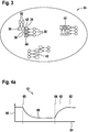
- FIG. 4a shows the time program 12 of the heating system 14.
- An abscissa axis 54 indicates a time.
- An ordinate axis 56 indicates an intended room temperature 58.
- a heating of a room is turned off, so that the intended room temperature 58 drops.
- From the scheduled departure time 60 there are probably no residents in the room.
- From a scheduled arrival time 62 at least one resident is expected to return to the room.
- the heating system 14 will turn on the heating of the room at a heating time 64 so that the room at the anticipated arrival time 62 has the desired room temperature.
- the heating time 64 is determined by subtracting a heating time from the scheduled time of arrival 62.
- the heating time is an empirically determined value stored in a control unit of the heating system 14.
- the time program 12 is stored in the data memory of the smartphone 68. It is regularly transmitted from the heating system 14 to the smartphone 68. If an arrival time 52 is determined which deviates sufficiently from the scheduled arrival time 62 set in the time program 12, the time program 12 is changed by changing the heating time 64. The new heating time 64 is determined by subtracting the heating time from the determined time of arrival 52. In the newly determined time program 12, the planned arrival time 62 is set to the value of the determined time of arrival 52.
- FIG. 4b shows a newly determined time program 12.
- the newly determined time program 12 is transmitted from the smartphone 68 to the heating system 14.
- the heating system 14 then regulates the room temperature as a function of the newly determined time program 12. If in particular the newly determined heating time 64 in the past, the heating system 14 begins largely immediately with the heating of the room.
- the route is stored in the historical route data 34 in the exemplary embodiment together with the cell properties 30 of its cells as historical route 42.
- the covered route is terminated as soon as a destination 50 or a destination cell 44 has been reached.
- a previously traveled partial route 32 becomes a completed route as soon as it is determined that the current Site cell 22 is a target cell 44.
- it is checked on the basis of two criteria whether the current location cell 22 is a target cell 44. If a cell dwell time in which the determined location coordinate 18 is continuously within the same location cell 22 is more than 20 minutes, the location cell 22 is classified as a target cell 44. If the cell dwell time is greater than 5 minutes and the average speed detected within the site cell 22 is less than 3 meters per second, the site cell 22 is classified as the target cell 44.
- the cell residence time and / or for the average velocity for classifying the site cell 22 as the target cell 44 are also conceivable.
- the cell residence time and / or average velocity limits depend on the technical conditions and other parameters of the method, for example, in particular, the size of the cells of the geodetic network 24.
- the type and / or number of criteria may be Checking whether the location cell 22 is a target cell 44 can be changed arbitrarily.
- the location cell 22 is compared with target cells 44 known from the past, for example with the target cells 44 of the stored historical routes 42.
- target cells 44 known from the past, for example with the target cells 44 of the stored historical routes 42.
- a criterion for classifying the location cell 22 as a target cell 44 are changed, in particular, the criterion can be simplified. In particular, a critical cell dwell time above which the site cell 22 is classified as a target cell 44 may be lowered and / or a critical speed below which the site cell 22 is classified as a target cell 44 may be increased.
- a criterion for checking whether the location cell 22 is a destination cell 44 depends on further information, for example on traffic information for the location cell 22 or on a calendar entry.
- a traffic jam can be taken into account, which would otherwise lead to an incorrect determination of the target cell 44.
- a criterion for classifying the location cell 22 as the destination cell 44 is changed, in particular, the criterion can be simplified.
- the criterion for classifying the location cell 22 as a target cell 44 is made more difficult.
- the cell in which the place of residence is selected or classified as the target cell 44.
- This has the advantage that all historical routes 42 have the place of residence as destination cell 44 or destination 50. In this way, it is also possible to determine an arrival time 52 at the place of residence, to whom an intermediate destination is initially headed. This allows an early prediction of the time of arrival 52 at the place of residence. If, for example, a sports studio is first visited after work and then the place of residence, the cell in which the sports studio is located would only be classified as an intermediate cell 38 in this particular variant. In a method 10 according to the embodiment, after leaving the start cell 36, the gym would be the predicted target cell 44 and the method will not determine an expected arrival time 52 at the residence until the end of the gym stay or until it leaves the appropriate cell.
- movement data stored in a mobile computing device for example a list of regularly recorded acquired location coordinates or location coordinates 18 is used to determine historical routes 42.
- a chain of successive cells of the geodetic network 24 is determined.
- target cells 44 of the chain of successive cells are determined.
- a sequence of historical routes 42 is determined depending on the chain of consecutive cells. This is especially of Advantage, when the method 10 is used for the first time. In this way, a good prediction of the expected route 28 can be made immediately, since there is historical route data 34, without the historical route data 34 having to be created or learned by traversing routes.
- FIG. 5 shows the heating system 14 and the smartphone 68.
- the smartphone 68 is a mobile computing device 70.
- the smartphone 68 has the GPS module 72, which is adapted to determine the location coordinate 18.
- the heating system 14 and the smartphone 68 are configured for communication via a server 74.
- the heating system 14 may send the currently used time program 12 to the smartphone 68.
- the smartphone 68 may send a new, in particular updated, time program 12 to the heating system 14, which then takes over the heating system 14 for further control or regulation.
- the smartphone 68 has a mobile radio modem 76, which is set up to establish an Internet connection with the server 74.
- the heating system 14 has a WLAN module 78, which is set up such that the heating system 14 can be connected via a home network at the place of residence to the server 74 via the Internet.
Landscapes
- Engineering & Computer Science (AREA)
- General Engineering & Computer Science (AREA)
- Physics & Mathematics (AREA)
- Thermal Sciences (AREA)
- Chemical & Material Sciences (AREA)
- Combustion & Propulsion (AREA)
- Mechanical Engineering (AREA)
- General Physics & Mathematics (AREA)
- Automation & Control Theory (AREA)
- Navigation (AREA)
- Telephonic Communication Services (AREA)
Abstract
Description
- Die Erfindung betrifft ein Verfahren zum Einstellen eines Zeitprogramms eines Heizsystems und/oder eines Zeitprogramms eines Systems zur Hausautomation. Die Erfindung betrifft auch ein Computerprogramm, das zum Ausführen einer Ausführungsform des Verfahrens gemäß der vorliegenden Erfindung eingerichtet ist, ein maschinenlesbares Speichermedium mit einem Computerprogramm gemäß der vorliegenden Erfindung sowie ein mobiles Rechengerät mit einem Computerprogramm gemäß der vorliegenden Erfindung.
- Moderne Heizsysteme bzw. Systeme zur Gebäudeautomatisierung erlauben es, eine Heizung einer Wohnung in Abhängigkeit von der Anwesenheit des Bewohners zu betreiben. Um Energie zu sparen, wird eine Wohnung bevorzugt nur dann beheizt, wenn der Bewohner anwesend ist. Typischerweise wird die Anwesenheit des Bewohners erkannt, wenn sich sein Smartphone in das WLAN-Netzwerk der Wohnung eingewählt hat oder ein GPS-Empfänger des Smartphones eine Position erfasst, die hinreichend nah an der Wohnung ist. Solche anwesenheitsbasierten Steuerungen haben den Nachteil, dass der Bewohner in einer kalte Wohnung ankommen kann, die erst nach seiner Ankunft beheizt wird.
- Die vorliegende Erfindung beschreibt ein Verfahren zum Einstellen eines Zeitprogramms eines Heizsystems und/oder eines Zeitprogramms eines Systems zur Hausautomation - beispielsweise eines Smart Home Systems - durch eine Vorhersage einer Ankunftszeit und eines Zielorts in Abhängigkeit von einer bisher zurückgelegten Teilroute, insbesondere mittels eines mobilen Rechengeräts.
- Das hat den Vorteil, dass durch die Vorhersage der Ankunftszeit und Zielorts das Heizsystem rechtzeitig vor einer Ankunft in Betrieb genommen werden kann. Gemäß der vorliegenden Erfindung wird ein Zeitprogramm des Heizsystems bzw. eines Systems zur Hausautomation eingestellt. Beispielsweise kann das Zeitprogramm so eingestellt sein, dass das Heizsystem an Werktagen ab einer bestimmten Uhrzeit eine Raumtemperatur erhöht, weil zu dieser Uhrzeit üblicherweise die Bewohner von der Arbeit zurückkommen. Wird nun durch das Verfahren eine vor oder nach dieser Uhrzeit liegenden Ankunftszeit vorhergesagt, kann das Zeitprogramm entsprechend angepasst werden, insbesondere kann die Uhrzeit, ab der das Heizsystem eine höhere Raumtemperatur bereitstellt, auf die ermittelte Ankunftszeit geändert werden.
- Unter "Heizsystem" ist insbesondere ein System aus mindestens einem Gerät zur Erzeugung von Wärmeenergie und/oder zum Empfangen von Wärmeenergie zu verstehen, insbesondere ein Heizgerät bzw. Heizbrenner, beispielsweise ein Brennwertkessel, insbesondere zur Verwendung in einer Gebäudeheizung und/oder zur Warmwassererzeugung, bevorzugt durch das Verbrennen von einem gasförmigen oder flüssigen Brennstoff oder durch elektrisches Heizen. Ein Heizsystem kann auch aus mehreren solchen Geräten zur Erzeugung von Wärmeenergie sowie weiteren, den Heizbetrieb unterstützenden Vorrichtungen, wie etwa einem Wasser- oder Brennstoffspeicher oder einer Wasser- oder Brennstoffpumpe oder einem Ausdehnungsgefäß, bestehen.
- Unter "System zur Hausautomation" oder "Smart Home System" ist insbesondere ein System zur automatischen oder wenigstens teilautomatischen Durchführung und/oder Steuerung und/oder Regelung von Funktionsabläufen in einem Gebäude zu verstehen, insbesondere von Wohnhäusern, insbesondere nach vorgegebenen Einstellparametern. Insbesondere umfasst ein System zur Hausautomation die Steuerung und/oder Regelung von Funktionsabläufen der Gebäudesicherheit bzw. Gebäudeüberwachung und/oder des Energiemanagements und/oder der Gebäudeheizung und/oder der Warmwasserversorgung und/oder der Beleuchtung und/oder von Haushaltsgeräten und/oder von Unterhaltungselektronik. Ein System zur Hausautomation kann beispielsweise ein Heizsystem und/oder ein Beleuchtungssystem umfassen. Insbesondere sind die Vorrichtungen eines Systems zur Hausautomation, beispielsweise Sensoren, Aktoren, Bedienelemente, Verbraucher und sonstige technische Einheiten, miteinander vernetzt. Ein System zur Hausautomation ist oft zur Kommunikation bzw. zum Datenaustausch mit einem entfernten, bevorzugt mobilen Rechengerät eingerichtet, beispielsweise über das Internet, insbesondere durch eine Cloud. Auf diese Weise können Funktionsabläufe im Gebäude ferngesteuert werden, beispielsweise eine gewünschte Raumtemperatur eingestellt werden. Es kann auch möglich sein, Informationen aus dem Gebäude zu empfangen, beispielsweise eine Aufnahme einer Überwachungskamera oder eine gemessene Raumtemperatur. Mit "Smart Home System" ist manchmal ein System zur Hausautomation gemeint, bei dem eine intelligente Steuerung im Vordergrund steht, beispielsweise durch selbstlernende Algorithmen.
- Unter "Zeitprogramm" soll insbesondere ein einstellbarer Ablaufplan von Funktion und/oder Parametern eines Heizsystems und/oder eines Systems zur Hausautomation verstanden werden. Das Heizsystem bzw. das System zur Hausautomation werden in Abhängigkeit vom Zeitprogramm betrieben, so dass die im Zeitprogramm festgelegten Funktionen und/oder Parameter zu den festgelegten Zeiten möglichst durchgeführt bzw. angenommen werden. Beispielsweise kann in einem Zeitprogramm gespeichert sein, welche Raumtemperatur bei welcher Uhrzeit gewünscht ist. Auf diese Weise kann zum Beispiel tagsüber, wenn voraussichtlich keine Bewohner im Gebäude anwesend sind, die Raumtemperatur abgesenkt werden. Auf diese Weise kann Heizenergie eingespart werden.
- Unter "Rechengerät" ist insbesondere eine Vorrichtung zu verstehen, die dazu eingerichtet ist, zumindest Teile des Verfahrens gemäß der vorliegenden Erfindung durchzuführen. Insbesondere kann das Rechengerät einen Datenspeicher, eine Recheneinheit und Mittel zum Empfangen und/oder Erfassen von Standortdaten bzw. von einer Standortkoordinate sowie Mittel zum Senden von Daten an das Heizsystem bzw. an ein System zur Hausautomation umfassen. Bevorzugt ist das Rechengerät dazu eingerichtet, in Abhängigkeit von der bisher zurückgelegten Teilroute wenigstens die Ankunftszeit und den Zielort vorherzusagen, bevorzugt eine erwartete Route zu ermitteln, wobei die erwartete Route eine Vorhersage eines weiteren Verlaufs einer bisher zurückgelegten Teilroute darstellt. Beispiele für Rechengeräte sind PCs, Smartphones, Server oder Raumbedieneinheiten für Heizsysteme und/oder Systeme zur Hausautomation.
- Ein "mobiles Rechengerät" ist ein Rechengerät, welches insbesondere dazu vorgesehen ist, von einem Benutzer tragbar zu sein und an verschiedenen Orten, bevorzugt beliebigen Orten, einsetzbar zu sein. Beispiele für mobile Recheneinheiten sind Smartphones, Tablets, Smart Watches oder Notebooks.
- Unter "Vorhersage der Ankunftszeit und des Zielorts" ist insbesondere das Ermitteln einer in Abhängigkeit von vorliegenden Information wahrscheinlichsten Ankunftszeit und eines in Abhängigkeit von vorliegenden Informationen wahrscheinlichsten Zielorts zu verstehen.
- Eine "Teilroute" ist eine noch nicht vollständig zurückgelegte Route. Die Teilroute beschreibt einen Weg von einem Startort zu einem aktuellen Standort. Eine "Route" beschreibt den Weg von einem Startort zu einem Zielort. Eine Route setzt sich wenigstens aus Ortsinformationen zusammen, welche den Weg wenigstens näherungsweise beschreiben. Eine Route kann sich beispielsweise aus diskreten Ortskoordinaten, beispielsweise GPS-Koordinaten, zusammensetzen, welche entlang des Weges liegen.
- Durch die in den Unteransprüchen aufgeführten Merkmale sind vorteilhafte Weiterbildungen des erfindungsgemäßen Verfahrens möglich.
- Vorteilhaft umfasst das Verfahren die Schritte
- Ermitteln einer Standortkoordinate
- Ermitteln einer Standortzelle eines geodätischen Netzes in Abhängigkeit von der Standortkoordinate,
- Ermitteln einer erwarteten Route in Abhängigkeit von der Standortzelle, wobei die erwartete Route eine Vorhersage der Ankunftszeit und des Zielorts umfasst,
- Einstellen des Zeitprogramms in Abhängigkeit von der erwarteten Route, insbesondere in Abhängigkeit von der von der erwarteten Route abhängigen Ankunftszeit.
- Dass das Verfahren weitgehend vollständig auf einem bevorzugt mobilen Rechengerät des Benutzers durchführbar ist, hat den zusätzlichen Vorteil, dass zur Durchführung des Verfahrens keine persönlichen Standortdaten und/oder Bewegungsdaten versendet bzw. weitergegeben werden müssen. Auf diese Weise wird eine Privatsphäre des Benutzers geschützt.
- Die Verwendung eines geodätischen Netzes zur Ermittlung der Standortzelle hat den Vorteil, dass keine Kartendaten notwendig sind. Es wird kein Speicherplatz für Kartendaten benötigt. Es ist insbesondere nicht notwendig, Kartendaten auf einem mobilen Rechengerät, insbesondere Smartphone zu empfangen.
- Das Verfahren wird weiter verbessert durch die Schritte
- Ermitteln einer erwarteten Route in Abhängigkeit von historischen Routendaten (34), wobei die erwartete Route (28) eine Vorhersage der Ankunftszeit (52) und des Zielorts (50) umfasst und die historischen Routendaten (34) durch früher abgespeicherte historische Routen (42) gebildet werden,
- Einstellen des Zeitprogramms in Abhängigkeit von der erwarteten Route, insbesondere in Abhängigkeit von der von der erwarteten Route abhängigen Ankunftszeit.
- Die Verwendung von historischen Routendaten macht die Vorhersage der erwarteten Route besonders zuverlässig.
- Unter "Standortkoordinate" soll eine aktuell ermittelte Ortskoordinate verstanden werden. Die Standortkoordinate beschreibt den aktuellen Standort. Eine Standortkoordinate kann eine geographische Koordinate sein, beispielsweise eine Angabe der geographischen Breite und geographischen Länge.
- Unter "geodätisches Netz" ist eine Unterteilung einer gesamten Erdoberfläche oder wenigstens eines Teils der Erdoberfläche in Flächenelemente zu verstehen, wobei die Flächenelemente die gesamte Erdoberfläche bzw. den Teil der Erdoberfläche weitgehend vollständig abdecken. Bevorzugt haben die Flächenelemente eine regelmäßige Struktur, beispielsweise durch eine gitterförmige Anordnung. Besonders bevorzugt wird das geodätische Netz durch ein rechtwinkliges Gitter gebildet, beispielsweise durch Linien konstanter geographischer Breite und Linien konstanter geographischer Höhe. Ein Beispiel für ein bevorzugtes geodätisches Netz ist das Maidenhead Locator System bzw. QTH-Gittersystem.
- Eine "Standortzelle" ist das Flächenelement des geodätischen Netzes, in der die Standortkoordinate liegt. Die Standortzelle repräsentiert den aktuellen Standort. Die Standortzelle wird im Maidenhead Locator System mit der Angabe eines QTH-Locators beschrieben.
- Die "erwartete Route" ist eine Route und beschreibt insbesondere einen Zielort. Die erwartete Route beschreibt insbesondere den Weg von der Standortzelle bzw. von der Standortkoordinate zum Zielort. Es ist möglich, dass sich die erwartete Route aus einer Beschreibung des Wegs mit einer Zeitinformation zusammensetzt. Beispielsweise kann sich die erwartete Route aus diskreten Ortskoordinaten zusammensetzen, wobei zu jeder Ortskoordinate ein Zeitpunkt gespeichert ist. Beispielsweise kann die erwartete Route eine historische Route sein, die früher durchlaufen wurde und bei der zusammen mit der Ortskoordinaten der entsprechende Zeitpunkte ermittelt und gespeichert wurde. Auf diese Weise kann die erwartete Ankunftszeit besonders einfach aus der erwarteten Route ermittelt werden. Es ist auch denkbar, in Abhängigkeit von der erwarteten Route eine Ankunftszeit zu ermitteln, beispielsweise durch Bestimmen der noch nötigen Wegstrecke zu Zielort anhand der erwarteten Route und einer erwarteten Durchschnittsgeschwindigkeit.
- Ist die eine Route, insbesondere die historische Route oder die erwartete Route, aus einer Startzelle, einer Zielzelle und dazwischen liegenden Zwischenzellen zusammengesetzt, hat das den Vorteil, dass das Verfahren weiter vereinfacht wird. Die Startzelle, Zielzelle und die dazwischen liegenden Zwischenzellen sind jeweils Zellen des geodätischen Netzes. Die Route wird durch eine Kette aus Zellen mit einer wohldefinierten Reihenfolge, beginnend mit der Startzelle und endend mit der Zielzelle, beschrieben.
- Eine Route, die sich aus der Startzelle, Zielzelle und den dazwischen liegenden Zwischenzellen zusammensetzt, hat einen reduzierten Informationsgehalt bzw. eine geringere Datenmenge, insbesondere gegenüber einer Route, die sich aus hoch aufgelösten Ortskoordinaten zusammensetzt. Auf diese Weise können Routendaten durch das Verfahren schneller bzw. mit einem geringeren Rechenaufwand berücksichtigt bzw. verarbeitet werden. Insbesondere wird die Datenmenge der historischen Routendaten auf diese Weise reduziert. Das verringert den Speicherbedarf des Verfahrens. Die Zuverlässigkeit und Geschwindigkeit beim Ermitteln der erwarteten Route in Abhängigkeit von historischen Routendaten wird erhöht. Auf diese Weise wird eine Durchführbarkeit des Verfahrens auch auf Rechengeräten mit geringer Rechenleistung und/oder geringem Datenspeicherplatz weiter verbessert.
- Ein zusätzlicher Vorteil ist, dass auf diese Weise sehr ähnliche Wege bzw. Wege, die sich mit einer örtlichen Abweichung unterscheiden, die kleiner ist als die Größe einer Zelle des geodätischen Netzes, der gleichen Route zugeordnet werden können. Auf diese Weise können Ungenauigkeiten beim Ermitteln der Standortkoordinate und/oder beim Durchlaufen des Weges auftretende kleine Variation, beispielsweise durch ein Umfahren einer Baustelle, automatisch nicht in der Route berücksichtigt werden. Das macht das Verfahren besonders robust und zuverlässig.
- Das Verfahren wird weiter verbessert, wenn wenigstens eine Zelleneigenschaft der Standortzelle ermittelt wird - beispielsweise eine Bewegungsrichtung und/oder eine Startzelle der Teilroute und/oder eine Routenrichtung der Teilroute und/oder eine Zeit, beispielsweise eine aktuelle Zeit oder einer Startzeit der Teilroute - und die erwartete Route in Abhängigkeit von der wenigstens einen Zelleneigenschaft ermittelt wird. Die Zuverlässigkeit des Verfahrens wird weiter erhöht, da die Zelleneigenschaft eine genauere Ermittlung der erwarteten Route ermöglicht. Vorteilhaft ist die Verwendung mehrerer Zelleneigenschaften, beispielsweise eine aktuelle Zeit und eine Routenrichtung.
- Unter "Zelleneigenschaft" ist insbesondere eine Information zu verstehen, welche von der ermittelten Standortzelle bzw. Standortkoordinate abhängt und/oder welche von der bisher zurückgelegten Teilroute abhängt. Beispiele für eine Information, welche von der ermittelten Standortzelle bzw. Standortkoordinate abhängt sind eine mit der Standortkoordinate erfasste momentane Geschwindigkeit oder eine innerhalb der Standortzelle erfasste mittlere Geschwindigkeit oder eine momentane Bewegungsrichtung oder eine mittlere Bewegungsrichtung oder ein Zeitpunkt - insbesondere eine aktuelle Uhrzeit und/oder ein aktuell vorliegender Wochentag - an dem die Standortkoordinate ermittelt wurde oder die bisher innerhalb der Standortzelle verbrachte Zeit oder eine innerhalb der Standortzelle empfangene Wetterinformation oder Verkehrsinformation. Beispiele für eine Information, welche von der bisher zurückgelegten Route abhängt sind eine Information, die von der Startzelle abhängt oder die Startzelle oder eine Startzeit oder eine bisher benötigte Zeit zum Durchlaufen der Teilroute oder eine mittlere Bewegungsrichtung oder eine mittlere Geschwindigkeit oder eine Anzahl der bisher zurückgelegten Zellen oder eine vor der Standortzelle durchlaufene Zelle oder ein Verbindungsvektor zwischen der Standortzelle und der vor der Standortzelle durchlaufenen Zelle oder eine Wetter- oder Verkehrsinformation, welche in der Startzelle empfangen wurde.
- Eine besonders vorteilhafte Zelleneigenschaft der Standortzelle ist ein Teilroutenvektor, der die Standortzelle mit der Startzelle verbindet. Auf diese Weise werden eine mittlere Bewegungsrichtung und ein Startort der bisher zurückgelegten Teilroute beim Ermitteln der erwarteten Route berücksichtigt. Das hat den Vorteil, dass zum zuverlässigen Ermitteln der erwarteten Route die vor der Standortzelle durchlaufenen Zellen der Teilroute nicht notwendig sind. Das Ermitteln in Abhängigkeit von einer Kette von Zellen ist numerisch besonders aufwendig. Eine benötigte Rechenzeit des Verfahrens steigt quadratisch mit der Anzahl von Zellen. Insbesondere wird die Durchführbarkeit des Verfahrens auf Rechengeräten mit geringer Rechenleistung und/oder geringem Datenspeicherplatz weiter verbessert.
- Die Genauigkeit und Zuverlässigkeit des Verfahrens wird weiter verbessert, wenn die historischen Routen zusammen mit wenigstens einer Zelleneigenschaft von einer Startzelle und/oder einer Zielzelle und/oder wenigstens einer dazwischen liegenden Zwischenzelle in den historischen Routendaten gespeichert sind. Bevorzugt ist jede Zelle einer historischen Route zusammen mit jeweils wenigsten einer Zelleneigenschaft in den historischen Routendaten gespeichert. In den historischen Routendaten kann die gleiche historische Route - also eine Route, die sich aus den gleichen Zellen zusammensetzt - mehrfach gespeichert sein, jeweils mit einer unterschiedlichen wenigstens einen Zelleneigenschaft. Beispielsweise kann die wenigstens eine Zelleneigenschaft ein Wochentag sein. Wird eine gleiche Route jeden Tag zurückgelegt, beispielsweise ein Weg zur Arbeit, ist diese Route als historische Route mehrfach in den historischen Routendaten gespeichert, jeweils mit einem anderen Wochentag als Zelleneigenschaft. Je höher eine Anzahl von historischen Routen in den historischen Routendaten, umso höher ist eine Wahrscheinlichkeit, dass die ermittelte erwartete Route dem tatsächlichen weiteren Verlauf der Teilroute entspricht. Die Qualität der ermittelten Teilroute wird gesteigert.
- Das Verfahren wird weiter verbessert, wenn beim Ermitteln der erwarteten Route als erwartete Route die historische Route ausgewählt wird, bei der die wenigstens eine Zelleneigenschaft der Zelle der historischen Route, die der Standortzelle entspricht, eine größtmögliche Ähnlichkeit zu der wenigstens einen Zelleneigenschaft der Standortzelle aufweist. Durch die Auswahl einer schon bekannten bzw. abgespeicherten historischen Route als erwartete Route wird das Verfahren besonders schnell und robust. Insbesondere bei sich häufig widerholenden Routen ist das Verfahren besonders sicher und effizient ausführbar.
- Insbesondere wird durch das Verfahren in den historischen Routendaten nur jeweils die Zelle einer historischen Route berücksichtigt, die der Standortzelle entspricht. Es ist nicht notwendig, die anderen Zellen einer historischen Route bei der Auswahl der erwarteten Route zu berücksichtigen. Das macht das Verfahren besonders schnell und einfach.
- Eine "größtmögliche Ähnlichkeit" von der wenigstens einen Zelleneigenschaft der Standortzelle zu der wenigstens einen Zelleneigenschaft der Zelle der historischen Route, die der Standortzelle entspricht kann vorteilhaft mit einer Metrik bzw. Abstandsfunktion der wenigstens einen Zelleneigenschaft definiert bzw. ermittelt werden.
- Eine besonders Vorteilhafte Realisierung des Verfahrens ist gegeben, wenn die erwartete Route durch einen k-Nearest-Neighbor-Algorithmus aus den historischen Routendaten ausgewählt wird und eine Zellenmetrik die wenigstens eine Zelleneigenschaft der Standortzelle mit der wenigstens einen Zelleneigenschaft der Zelle der historischen Route vergleicht, die der Standortzelle entspricht. Auf diese Weise lässt sich als erwartete Route die historische Route, bei der die wenigstens eine Zelleneigenschaft der Zelle der historischen Route, die der Standortzelle entspricht, eine größtmögliche Ähnlichkeit zur der wenigstens einen Zelleneigenschaft der Standortzelle aufweist, besonders schnell und genau ermitteln.
- Die "Zellenmetrik" ist eine Metrik, welche zwei Informationen bzw. Werten der wenigstens einen Zelleneigenschaft eine positive Zahl zuordnet, welche umso größer ist, je stärker sich die beiden Informationen bzw. Werte unterscheiden. Sind beide Informationen bzw. Werte der wenigstens einen Zelleneigenschaft gleich, liefert die Zellenmetrik den Wert Null. Ist beispielsweise die wenigstens eine Zelleneigenschaft ein Geschwindigkeitsvektor einer momentanen Geschwindigkeit, kann die Zellenmetrik als Betrag des Differenzvektors von zwei Geschwindigkeitsvektoren sein, wobei jede Komponente des Differenzvektors eine Geschwindigkeit in Metern pro Sekunde angibt. Ist die Zelleneigenschaft eine Uhrzeit, kann die Zellenmetrik eine positive Zeitdifferenz zwischen den Uhrzeiten in Minuten sein.
- Wird einer Zelle jeweils mehr als eine Zelleneigenschaft zugeordnet, kann die Zellenmetrik beispielsweise eine Summe von Metriken für jeweils eine Zelleneigenschaft sein. Wird beispielsweise jeder Zelle ein Geschwindigkeitsvektor und eine Uhrzeit zugeordnet, kann als Zellenmetrik die Summe aus einer Metrik für den Geschwindigkeitsvektor und aus einer Metrik für die Uhrzeit gewählt werden. Es ist denkbar, dass die eine Zellenmetrik bildenden einzelnen Metriken unterschiedlich stark gewichtet werden. Auf diese Weise ist es möglich, bestimmte Zelleneigenschaften stärker zu berücksichtigen als andere.
- Beim "k-Nearest-Neighbor-Algorithmus" wird ein Testobjekt klassifiziert. Dem Testobjekt wird eine von wenigstens zwei vorgegebenen Klassen eine zugeordnet. Dem Testobjekt wird in Abhängigkeit von einer Menge von bereits klassifizierten Objekten und einer Metrik, die den Abstand der Objekte bestimmt, eine Klasse zugeordnet. Es wird eine Anzahl k der bereits klassifizierten Objekte bestimmt, die den kleinsten Abstand zum Testobjekt haben. Es wird überprüft, welche Klassen die k bestimmten Objekte haben. Dem Testobjekt wird die Klasse zugeordnet, die die Mehrheit der k bestimmten Objekte hat.
- Im Verfahren sind die Klassen des k-Nearest-Neighbor-Algorithmus in bevorzugten Ausführungsformen die möglichen Routen, jeweils zusammengesetzt aus Startzelle, Zielzelle und Zwischenzellen. Es werden alle historischen Routen der historischen Routendaten zur Definition der Klassen verwenden. Die in den historischen Routendaten zusammen mit den historischen Routen gespeicherten Zelleneigenschaften werden nicht zum Klassifizieren bzw. zur Definition einer Klasse verwendet. In alternativen Ausführungsformen definieren die Zielzellen die Klassen. Es werden alle in den historischen Routendaten vorkommenden Zielzellen als Klassen verwendet.
- Es ist auch denkbar, dass nur ein Teil einer Kette von Zellen einer historischen Route als Klasse verwendet wird, insbesondere in Abhängigkeit von der ermittelten Standortzelle. Vorteilhaft weist der Teil der Kette von Zellen nur solche Zellen auf, die nach einer Zelle angeordnet sind, die der Standortzelle entspricht. Bei einer solchen vorteilhaften Variante werden als Klasse gekürzte historische Routen verwendet, bei denen die vor einer Zelle, die der Standortzelle entspricht, liegenden Zellen entfernt sind.
- Im Verfahren ist die Metrik des k-Nearest-Neighbor-Algorithmus die Zellenmetrik. Das Testobjekt des k-Nearest-Neighbor-Algorithmus ist die wenigstens eine Zelleneigenschaft der Standortzelle. Die bereits klassifizierten Objekte werden jeweils durch eine historische Route - als zugeordnete Klasse - in Verbindung mit der zusammen mit ihr abgespeicherten wenigstens eine Zelleneigenschaft der Zelle der historischen Route, die der Standortzelle entspricht, gebildet.
- Werden die historischen Routendaten nach Zielerreichung in Abhängigkeit von der beendeten Route aktualisiert, wird insbesondere die beendete Route, bevorzugt zusammen mit der wenigstens einen Zelleneigenschaft, in den historischen Routendaten abgespeichert, hat das den Vorteil, dass die Qualität der ermittelten erwarteten Route weiter erhöht wird. Die Wahrscheinlichkeit, dass die erwartete Route einer tatsächlichen Route entspricht, wird gesteigert. Durch das Aktualisieren der historischen Routendaten können insbesondere neue Routen, insbesondere Zielorte bzw. Zielzellen, des Bewohners gelernt und durch das Verfahren berücksichtigt werden.
- Unter "Aktualisieren der historischen Routendaten" soll insbesondere verstanden werden, dass beendete Routen in den historischen Routendaten abgespeichert werden, bevorzugt zusammen mit der wenigstens einen Zelleneigenschaft, und/oder dass historische Routen, die innerhalb einer vorgegebenen Zeitspanne, beispielsweise innerhalb von einem Jahr, nicht mehr durchlaufen wurden, aus den historischen Routendaten entfernt werden. Es ist auch denkbar, dass historische Routen mit einem Zielort bzw. einer Zielzelle, der bzw. die innerhalb einer vorgegebenen Zeitspanne nicht mehr erreicht wurde, aus den historischen Routendaten entfernt werden. Auf diese Weise werden nicht mehr relevante historische Routen nicht mehr berücksichtigt. Die Qualität und Genauigkeit des Verfahrens wird weiter verbessert.
- Ein weiterer Aspekt der vorliegenden Erfindung ist ein Computerprogramm, welches dazu eingerichtet ist, eine Ausführungsform des Verfahrens gemäß der vorliegenden Erfindung auszuführen. Insbesondere veranlasst das Computerprogramm ein Rechengerät, eine Ausführungsform des Verfahrens gemäß der vorliegenden Erfindung durchzuführen, wenn es auf dem Rechengerät ausgeführt wird.
- Ein weiterer Aspekt der vorliegenden Erfindung ist ein maschinenlesbares Speichermedium. Auf dem maschinenlesbaren Speichermedium ist das Computerprogramm gemäß der vorliegenden Erfindung gespeichert.
- Eine weitere vorteilhafte Ausführungsform der Erfindung manifestiert sich in einem mobilen Rechengerät, insbesondere Smartphone, mit einem Sensor zur Erfassung einer Standortkoordinate - beispielsweise einem GPS-Modul - und/oder einem Empfänger zum Empfangen einer Standortkoordinate - beispielsweise ein Mobilfunkmodem - und einem Sender zum Senden von Daten an ein Heizsystem und/oder ein Systems zur Hausautomation - beispielsweise ein Mobilfunkmoden, wobei das mobile Rechengerät durch eine entsprechende integrierte Schaltung und/oder ein auf einem Speicher gespeichertes Computerprogramm dazu eingerichtet ist, ein Verfahren gemäß der vorstehenden Ausführungen auszuführen.
- In den Zeichnungen sind Ausführungsbeispiele des Verfahrens zum Einstellen eines Zeitprogramms gemäß der vorliegenden Erfindung sowie ein mobiles Rechengerät gemäß der vorliegenden Erfindung dargestellt und in der nachfolgenden Beschreibung näher erläutert. Es zeigen
-
Figur 1 zeigt das Verfahren zum Einstellen eines Zeitprogramms gemäß der vorliegenden Erfindung, -
Figur 2 ein geodätisches Netz mit einer Teilroute und einer erwarteten Route, -
Figur 3 eine schematische Darstellung von historischen Routendaten, -
Figuren 4a und4b ein Zeitprogramm eines Heizsystems jeweils vor und nach der Einstellung durch das Verfahren und -
Figur 5 ein mobiles Rechengerät gemäß der vorliegenden Erfindung mit dem Heizsystem. - In den verschiedenen Ausführungsvarianten erhalten gleiche Teile bzw. Schritte die gleichen Bezugszahlen.
- In
Figur 1 ist ein Verfahren 10 zum Einstellen eines Zeitprogramms 12 eines Heizsystems 14 dargestellt. In einem ersten Schritt 16 wird eine Standortkoordinate 18 ermittelt. Im Ausführungsbeispiel wird die Standortkoordinate 18 durch ein GPS-Modul 72 eines Smartphones 68 ermittelt. - In einem nächsten Schritt 20 wird in Abhängigkeit von der Standortkoordinate 18 eine Standortzelle 22 ermittelt. Die Standortzelle 22 ist eine Zelle eines geodätischen Netzes 24, welches durch das Maidenhead Locator System definiert ist.
-
Figur 2 zeigt das geodätische Netz 24. Im Ausführungsbeispiel wird ein Maidenhead Locator System vierter Stufe verwendet, bei dem zur Beschreibung der Zellen achtstellig QTH-Locatoren verwendet werden. Die Zellen haben in Deutschland eine Diagonale mit einer Länge von etwa 700 Metern. Die Standortzelle 22 ist die Zelle, in der sich die Standortkoordinate 18 befindet. Das geodätische Netz 24 ist in einem Datenspeicher des Smartphones 68 hinterlegt. Schritt 20 wird durch das Smartphone 68 durchgeführt. - In Varianten des Ausführungsbeispiels kann auch ein Maidenhead Locator System einer anderen Stufe verwendet werden. Beispielsweise kann ein Maidenhead Locator System fünfter Stufe verwendet, bei dem zur Beschreibung der Zellen zehnstellige QTH-Locatoren verwendet werden. Die Zellen haben in Deutschland eine Diagonale mit einer Länge von etwa 30 Metern.
- In einem weiteren Schritt 26 wird eine erwartete Route 28 ermittelt. Die erwartete Route 28 wird in Abhängigkeit von der Standortzelle 22, von drei Zelleneigenschaften 30, von einer bisher zurückgelegten Teilroute 32 und von historischen Routendaten 34 bestimmt.
- Die bisher zurückgelegte Teilroute 32 setzt sich im in
Figur 2 gezeigten Beispiel aus einer Startzelle 36, zwei Zwischenzellen 38 und der Standortzelle 22 zusammen. In denFiguren 2 und3 werden die Routen, insbesondere die Teilroute 32, die erwartete Route 28 und die historischen Routen 42, jeweils mit einem Pfeil dargestellt, welcher die Zellen verbindet, aus denen sich die Route zusammensetzt. Die Teilroute 32 ist im Datenspeicher des Smartphones 68 hinterlegt. Beginnend mit einem Start der Teilroute wird durch das Smartphone 68 periodisch eine aktuelle Standortkoordinate 18 und die aktuelle Standortzelle 22 ermittelt. Im Ausführungsbeispiel wird die aktuelle Standortkoordinate 18 alle 30 bis 60 Sekunden ermittelt. Eine Häufigkeit der Ermittlung der Standortkoordinate 18 kann dynamisch an eine mittlere Geschwindigkeit angepasst werden, insbesondere kann die Standortkoordinate 18 umso häufiger ermittelt werden, je größer die mittlere Geschwindigkeit ist. Die mittlere Geschwindigkeit kann beispielsweise mit einem Beschleunigungssensor des Smartphones 68 ermittelt werden. - In alternativen Varianten wird durch das Smartphone 68 regelmäßig, beispielsweise weniger als alle 60 Sekunden, bevorzugt weniger als alle 30 Sekunden, besonders bevorzugt weniger als alle 10 Sekunden, eine aktuelle Standortkoordinate 18 und die aktuelle Standortzelle 22 ermittelt. Die Wahl der Häufigkeit der Ermittlung der Standortkoordinate 18 richtet sich an den technischen Anforderungen. Ein häufiges Ermitteln der Standortkoordinate 18 - insbesondere über das GPS-Modul 72 - erhöht einen Energieverbrauch des Smartphones 68. Ein seltenes Ermitteln der Standortkoordinate 18 senkt die Präzision bei der Ermittlung der Standortzelle 22 und eine Vorhersagequalität des Verfahrens 10.
- Die bisher zurückgelegte Teilroute 32 wird als Abfolge von nacheinander betretenen Zellen gespeichert. Sobald sich eine erfasste Standortkoordinate 18 außerhalb der bisherigen Standortzelle 22 befindet, wird die bisherige Standortzelle 22 als Zwischenzelle 38 oder, falls es die erste Zelle der Teilroute 32 war, als Startzelle 36 kategorisiert und gespeichert. Die Zelle, in der sich die erfasste Standortkoordinate 18 befindet, wird als neue, aktuelle Standortzelle 22 erfasst. Auf dieses Weise wird die Teilroute 32 iterativ ermittelt und im Smartphone 68 gespeichert.
- Im Ausführungsbeispiel sind die drei Zelleneigenschaften 30 der Standortzelle 22 ein Teilroutenvektor 40 (siehe
Figur 2 ), ein vorliegender Wochentag und eine Uhrzeit, bei der die Standortzelle 22 erstmals ermittelt wurde. - In Varianten des Ausführungsbeispiels wird als Zelleneigenschaft 30 ein erster Richtungsvektor verwendet, der die Standortzelle 22 mit der letzten Zwischenzelle 38 verbindet bzw. mit der Zwischenzelle 38, die vor dem Betreten der aktuellen Standortzelle 22 durchlaufen wurde.
- In einer weiteren Variante wird, sobald wenigstens drei Zwischenzellen 38 vorhanden sind, als Zelleneigenschaft 30 ein zweiter Richtungsvektor verwendet, der die Standortzelle 22 mit der drittletzten Zwischenzelle 38 verbindet.
- In einer weiteren Variante des Ausführungsbeispiels wird, sobald wenigstens fünf Zwischenzellen 38 vorhanden sind, als Zelleneigenschaft 30 ein dritter Richtungsvektor verwendet, der die Standortzelle 22 mit der fünftletzten Zwischenzelle 38 verbindet.
Die historischen Routendaten 34 werden aus historischen Routen 42 gebildet. Die historischen Routendaten 34 sind schematisch inFigur 3 abgebildet. Jede historische Route 42 setzt sich jeweils aus einer Startzelle 36, aus einer Zielzelle 44 und optional aus wenigstens einer Zwischenzelle 38 zusammen. In den historischen Routendaten 34 sind zu jeder historischen Route die Zelleneigenschaften 30 gespeichert. Zu jeder Zelle einer historischen Route 42 sind jeweils die Zelleneigenschaften 30 gespeichert. Die historischen Routendaten 34 sind im Datenspeicher des Smartphone 68 gespeichert. - Die erwartete Route 28 wird ermittelt, in dem als erwartete Route 28 eine historische Route 42 aus den historischen Routendaten 34 ausgewählt wird, welche von einem k-Nearest-Neighbor-Algorithmus ermittelt wird. Der k-Nearest-Neighbor-Algorithmus verwendet eine Zellenmetrik, die die Zelleneigenschaften der Standortzelle 22 mit den Zelleneigenschaften der Zelle einer historischen Route 42 vergleicht, die der Standortzelle 22 entspricht. Bei der Auswahl durch den k-Nearest-Neigbor-Algorithmus werden nur diejenigen historischen Routen 42 berücksichtigt, welche eine Zelle aufweisen, die der Standortzelle 22 entspricht.
- Im Ausführungsbeispiel wird im k-Nearest-Neigbor-Algorithmus ein Parameter k mit dem Wert 7 verwendet. Es werden also diejenigen 7 Paare aus historischen Routen 42 und zugehörigen Zelleneigenschaften 30 (siehe
Figur 3 ) zur Klassifizierung der Standortzelle 22 bzw. der bisher zurückgelegten Route verwendet, die die größte Ähnlichkeit zu den Zelleneigenschaften 30 der Standortzelle 22 haben. In alternativen Ausführungsformen liegt der Parameter k zwischen 5 und 11, bevorzugt zwischen 3 und 13. Bevorzugt ist der Paramater k eine ungerade Zahl, so dass immer eine Mehrheitsentscheidung möglich ist. Es ist denkbar, dass der Parameter k in Abhängigkeit von der Größe der historischen Routendaten 34 gewählt wird. Beispielsweise kann der Parameter k umso größer gewählt werden, je größer die Anzahl der historischen Routendaten 34 ist. Das Ermitteln der erwarteten Route 28 wird auf dem Smartphone 68 durchgeführt. - In weiteren Ausführungsvarianten wird der Parameter k adaptiv gewählt. Als Minimalwert hat der Parameter k den Wert 5. Je mehr historische Routen 42 es gibt, die der Teilroute 32 ähnlich sind, umso größer wird der Parameter k gewählt. Als Maximalwert hat der Parameter k den Wert 11. In einer bevorzugten Ausführungsvariante wird die Ähnlichkeit der historischen Routen 42 zur Teilroute 32 ermittelt, indem mit der Zellenmetrik der Abstand der Standortzelle 22 mit der Zelle der historischen Route 42, die der Standortzelle 22 entspricht, ermittelt wird. Je größer die Zahl der historischen Routen 42, die einen vorgegebenen Maximalabstand zur Teilroute 22 unterschreiten, umso größer wird der Parameter k gewählt.
- In Schritt 26 werden ein erwarteter Zielort 50 und eine erwartete Ankunftszeit 52 ermittelt. Der erwartete Zielort 50 wird anhand von der Zielzelle 44 der erwarteten Route 28 bestimmt. Im Ausführungsbeispiel wird der Zielort 50 durch die Zielzelle 44 der erwarteten Route 28 beschrieben. Die erwartete Ankunftszeit 52 wird in Abhängigkeit von der erwarteten Route 28 ermittelt. Im Ausführungsbeispiel wird die Ankunftszeit 52 in Abhängigkeit der Uhrzeit ermittelt, welche als Zelleneigenschaft 30 der erwarteten Routen 28 in den historischen Routendaten gespeichert wird. Es wird eine Restroutendauer als die zeitliche Differenz zwischen der Uhrzeit der Zielzelle 44 der erwarteten Route 28 und der Uhrzeit der Zelle der erwarteten Route 28, welche der Standortzelle 22 entspricht, ermittelt. Die Ankunftszeit 52 wird ermittelt, indem die Restroutendauer auf die Uhrzeit der Standortzelle 22 addiert wird.
- In einem weiteren Schritt 46 wird das Zeitprogramm 12 des Heizsystems 14 eingestellt. Dazu wird zunächst überprüft, ob der erwartete Zielort 50 der erwarteten Route 28 einem Wohnort entspricht, an dem das Heizsystem 14 installiert ist. Das Zeitprogramm 12 des Heizsystems 14 wird im Ausführungsbeispiel eingestellt bzw. aktualisiert, wenn sich der Wohnort innerhalb von der Zielzelle 44 der erwarteten Route 28 befindet. Insbesondere kann ein neuer Zeitpunkt zum Einschalten einer Heizung eines Raums eingestellt werden.
-
Figur 4a zeigt das Zeitprogramm 12 des Heizsystems 14. Eine Abszissenachse 54 zeigt eine Uhrzeit an. Eine Ordinatenachse 56 zeigt eine vorgesehene Raumtemperatur 58 an. Ab einer vorgesehenen Abfahrtszeit 60 wird eine Heizung eines Raumes abgeschaltet, so dass die vorgesehene Raumtemperatur 58 absinkt. Ab der vorgesehenen Abfahrtszeit 60 befinden sich voraussichtlich keine Bewohner im Raum. Ab einer vorgesehenen Ankunftszeit 62 wird voraussichtlich wenigstens ein Bewohner in den Raum zurückkehren. Das Heizsystem 14 wird die Heizung des Raums zu einer Heizzeit 64 einschalten, so dass der Raum zur vorhergesehenen Ankunftszeit 62 die gewünschte Raumtemperatur hat. Die Heizzeit 64 wird ermittelt, indem eine Aufheizdauer von der vorgesehen Ankunftszeit 62 abgezogen wird. Die Aufheizdauer ist ein empirisch ermittelter Wert, der in einer Steuereinheit des Heizsystems 14 gespeichert ist. - Das Zeitprogramm 12 ist im Datenspeicher des Smartphones 68 hinterlegt. Es wird regelmäßig vom Heizsystem 14 an das Smartphone 68 übermittelt. Wird eine Ankunftszeit 52 ermittelt, die hinreichend stark von der im Zeitprogramm 12 eingestellten vorgesehenen Ankunftszeit 62 abweicht, wird das Zeitprogramm 12 geändert, indem die Heizzeit 64 verändert wird. Die neue Heizzeit 64 wird ermittelt, indem von der ermittelten Ankunftszeit 52 die Aufheizdauer abgezogen wird. Im neu ermittelten Zeitprogramm 12 wird die vorgesehene Ankunftszeit 62 auf den Wert der ermittelten Ankunftszeit 52 eingestellt.
-
Figur 4b zeigt ein neu ermitteltes Zeitprogramm 12. Das neu ermittelte Zeitprogramm 12 wird vom Smartphone 68 an das Heizsystem 14 übermittelt. Das Heizsystem 14 regelt die Raumtemperatur dann in Abhängigkeit vom neu ermittelten Zeitprogramm 12. Liegt insbesondere die neu ermittelte Heizzeit 64 in der Vergangenheit, beginnt das Heizsystem 14 weitgehend sofort mit dem Aufheizen des Raums. - Wird die Route beendet, wird sie im Ausführungsbeispiel zusammen mit den Zelleneigenschaften 30 ihrer Zellen als historische Route 42 in den historischen Routendaten 34 gespeichert.
- Die zurückgelegte Route ist beendet, sobald ein Zielort 50 bzw. eine Zielzelle 44 erreicht wurde. Im Ausführungsbeispiel wird eine bisher zurückgelegte Teilroute 32 zu einer beendeten Route, sobald festgestellt wird, dass die aktuelle Standortzelle 22 eine Zielzelle 44 ist. Im Ausführungsbeispiel wird anhand von zwei Kriterien überprüft, ob die aktuelle Standortzelle 22 eine Zielzelle 44 ist. Beträgt eine Zellenverweilzeit, in der sich die ermittelte Standortkoordinate 18 ununterbrochen innerhalb der gleichen Standortzelle 22 befindet, über 20 Minuten, wird die Standortzelle 22 als Zielzelle 44 klassifiziert. Beträgt die Zellenverweilzeit über 5 Minuten und ist die innerhalb der Standortzelle 22 erfasste mittlere Geschwindigkeit kleiner als 3 Meter pro Sekunde, wird die Standortzelle 22 als Zielzelle 44 klassifiziert.
- In Varianten sind auch andere Grenzwerte für die Zellenverweilzeit und/oder für die mittlere Geschwindigkeit zur Klassifizierung der Standortzelle 22 als Zielzelle 44 denkbar. Insbesondere hängen die Grenzwerte für die Zellenverweilzeit und/oder für die mittlere Geschwindigkeit von den technischen Bedingungen und anderen Parametern des Verfahrens ab, beispielsweise insbesondere von der Größe der Zellen des geodätischen Netzes 24. In alternativen Ausführungsformen kann die Art und/oder Anzahl von Kriterien zur Überprüfung, ob die Standortzelle 22 eine Zielzelle 44 ist, beliebig verändert werden.
- Es ist denkbar, dass zum Ermitteln, ob die bisher zurückgelegte Teilroute 32 beendet ist, die Standortzelle 22 mit aus der Vergangenheit bekannten Zielzellen 44 verglichen wird, beispielsweise mit den Zielzellen 44 der gespeicherten historischen Routen 42. Beispielsweise kann bei Standortzellen 22, die in den historischen Routendaten 34 gespeicherten Zielzellen 44 entsprechen, ein Kriterium zum Klassifizieren der Standortzelle 22 als Zielzelle 44 verändert werden, insbesondere kann das Kriterium vereinfacht werden. Insbesondere kann eine kritische Zellenverweilzeit, oberhalb der die Standortzelle 22 als Zielzelle 44 klassifiziert wird, abgesenkt werden und/oder eine kritische Geschwindigkeit, unterhalb der die Standortzelle 22 als Zielzelle 44 klassifiziert wird, erhöht werden.
- Es ist möglich, dass ein Kriterium zur Überprüfung, ob die Standortzelle 22 eine Zielzelle 44 ist, von weiteren Informationen abhängt, beispielsweise von einer Verkehrsinformation für die Standortzelle 22 oder von einem Kalendereintrag.
- Auf diese Weise kann beispielsweise ein Verkehrsstau berücksichtigt werden, der sonst zu einer falschen Ermittlung der Zielzelle 44 führen würde. Es ist denkbar, dass in Standortzellen 22, die einen Zielort 50 eines Termins in einem Kalender entsprechen, ein Kriterium zum Klassifizieren der Standortzelle 22 als Zielzelle 44 verändert wird, insbesondere kann das Kriterium vereinfacht werden. Es ist auch denkbar, dass in Standortzellen 22, die nicht einen Zielort 50 eines Termins in einem Kalender entsprechen, das Kriterium zum Klassifizieren der Standortzelle 22 als Zielzelle 44 erschwert wird.
- In einer besonderen Variante wird alleine die Zelle, in der sich der Wohnort befindet, als Zielzelle 44 gewählt bzw. klassifiziert. Das hat den Vorteil, dass alle historischen Routen 42 den Wohnort als Zielzelle 44 bzw. als Zielort 50 haben. Auf diese Weise kann auch eine Ankunftszeit 52 am Wohnort ermittelt werden, wen zunächst ein Zwischenziel angesteuert wird. Das ermöglicht eine frühzeitige Vorhersage der Ankunftszeit 52 am Wohnort. Wird beispielsweise nach der Arbeit zunächst ein Sportstudio aufgesucht und erst danach der Wohnort, würde die Zelle, in der sich das Sportstudio befindet, in dieser besonderen Variante nur als Zwischenzelle 38 klassifiziert. In einem Verfahren 10 gemäß des Ausführungsbeispiels wäre nach Verlassen der Startzelle 36 das Sportstudio die vorhergesagte Zielzelle 44 und das Verfahren wird bis zum Ende des Aufenthalts im Sportstudio bzw. bis zum Verlassen der entsprechenden Zelle keine erwartete Ankunftszeit 52 am Wohnort ermitteln.
- In einer weiteren Ausführungsform werden in einem mobilen Rechengerät, insbesondere in einem Smartphone 68 hinterlegte Bewegungsdaten, beispielsweise eine Liste von regelmäßig gespeicherten erfassten Ortskoordinaten bzw. Standortkoordinaten 18 zur Ermittlung von historischen Routen 42 verwendet. In Abhängigkeit von den Bewegungsdaten wird eine Kette von aufeinanderfolgenden Zellen des geodätischen Netzes 24 ermittelt. Anhand des Kriteriums zur Überprüfung, ob die Standortzelle 22 eine Zielzelle 44 ist, werden Zielzellen 44 der Kette von aufeinanderfolgenden Zellen bestimmt. Auf diese Weise wird in Abhängigkeit von der Kette von aufeinanderfolgenden Zellen eine Folge von historischen Routen 42 ermittelt. Das ist insbesondere von Vorteil, wenn das Verfahren 10 erstmals eingesetzt wird. Auf diese Weise kann sofort eine gute Vorhersage der erwarteten Route 28 erfolgen, da historische Routendaten 34 vorliegt, ohne dass die historischen Routendaten 34 durch ein Durchlaufen von Routen erstellt bzw. eingelernt werden muss.
-
Figur 5 zeigt das Heizsystem 14 und das Smartphone 68. Das Smartphone 68 ist ein mobiles Rechengerät 70. Das Smartphone 68 weist das GPS-Modul 72 auf, welches zum Ermitteln der Standortkoordinate 18 eingerichtet ist. Das Heizsystem 14 und das Smartphone 68 sind zur Kommunikation über einen Server 74 eingerichtet. Insbesondere kann das Heizsystem 14 das aktuell verwendete Zeitprogramm 12 an das Smartphone 68 senden. Das Smartphone 68 kann ein neues, insbesondere aktualisiertes Zeitprogramm 12 an das Heizsystem 14 senden, welches das Heizsystem 14 dann zur weiteren Steuerung bzw. Regelung übernimmt. - Das Smartphone 68 weist ein Mobilfunkmodem 76 auf, welches zum Herstellen einer Internetverbindung mit dem Server 74 eingerichtet ist. Das Heizsystem 14 hat ein WLAN-Modul 78, welches so eingerichtet ist, dass das Heizsystem 14 über ein Heimnetzwerk am Wohnort mit dem Server 74 über das Internet verbindbar ist.
Claims (13)
- Verfahren (10) zum Einstellen eines Zeitprogramms (12) eines Heizsystems (14) und/oder eines Zeitprogramms (12) eines Systems zur Hausautomation - beispielsweise eines Smart Home Systems - durch eine Vorhersage einer Ankunftszeit (52) und eines Zielorts (50) in Abhängigkeit von einer bisher zurückgelegten Teilroute (32), insbesondere mittels eines mobilen Rechengeräts (70).
- Verfahren (10) nach Anspruch 1, umfassend die Schritte• Ermitteln einer Standortkoordinate (18),• Ermitteln einer Standortzelle (22) eines geodätischen Netzes (24) in Abhängigkeit von der Standortkoordinate (18),• Ermitteln einer erwarteten Route (28) in Abhängigkeit von der Standortzelle (22, wobei die erwartete Route (28) eine Vorhersage der Ankunftszeit (52) und des Zielorts (50) umfasst,• Einstellen des Zeitprogramms (12) in Abhängigkeit von der erwarteten Route (28), insbesondere in Abhängigkeit von der von der erwarteten Route (28) abhängigen Ankunftszeit (52).
- Verfahren (10) nach Anspruch 1 oder 2, umfassend die Schritte• Ermitteln einer bzw. der erwarteten Route (28) in Abhängigkeit von historischen Routendaten (34), wobei die erwartete Route (28) eine Vorhersage der Ankunftszeit (52) und des Zielorts (50) umfasst und die historischen Routendaten (34) durch früher abgespeicherte historische Routen (42) gebildet werden,• Einstellen des Zeitprogramms (12) in Abhängigkeit von der erwarteten Route (28), insbesondere in Abhängigkeit von der von der erwarteten Route (28) abhängigen Ankunftszeit (52).
- Verfahren (10) nach einem der vorhergehenden Ansprüche, dadurch gekennzeichnet, dass eine Route, insbesondere die historische Route (42) oder die erwartete Route (28), aus einer Startzelle (36), einer Zielzelle (44) und dazwischen liegenden Zwischenzellen (38) zusammengesetzt ist.
- Verfahren (10) nach einem der vorhergehenden Ansprüche, dadurch gekennzeichnet, dass wenigstens eine Zelleneigenschaft (30) der Standortzelle (22) ermittelt wird - beispielsweise eine Bewegungsrichtung und/oder eine Startzelle der Teilroute (32) und/oder eine Routenrichtung der Teilroute (32) und/oder eine Zeit, beispielsweise eine aktuelle Zeit oder einer Startzeit der Teilroute (32) - und die erwartete Route (28) in Abhängigkeit von der wenigstens einen Zelleneigenschaft (30) ermittelt wird.
- Verfahren (10) nach Anspruch 5, dadurch gekennzeichnet, dass die wenigstens eine Zelleneigenschaft (30) der Standortzelle (22) ein Teilroutenvektor (40) ist, der die Standortzelle (22) mit der Startzelle (36) verbindet.
- Verfahren (10) nach einem der vorhergehenden Ansprüche, dadurch gekennzeichnet, dass die historischen Routen (42) zusammen mit wenigstens einer Zelleneigenschaft (30) von einer Startzelle (36) und/oder einer Zielzelle (44) und/oder wenigstens einer dazwischen liegenden Zwischenzelle (38) in den historischen Routendaten (34) gespeichert sind.
- Verfahren (10) nach einem der vorhergehenden Ansprüche, dadurch gekennzeichnet, dass beim Ermitteln der erwarteten Route (28) als erwartete Route (28) die historische Route (42) ausgewählt wird, bei der die wenigstens eine Zelleneigenschaft (30) der Zelle der historischen Route (42), die der Standortzelle (22) entspricht, eine größtmögliche Ähnlichkeit zu der wenigstens einen Zelleneigenschaft (30) der Standortzelle (22) aufweist.
- Verfahren (10) nach Anspruch 8, dadurch gekennzeichnet, dass die erwartete Route (28) durch einen k-Nearest-Neighbor-Algorithmus aus den historischen Routendaten (34) ausgewählt wird und eine Zellenmetrik die wenigstens eine Zelleneigenschaft (30) der Standortzelle (22) mit der wenigstens einen Zelleneigenschaft (30) der Zelle der historischen Route (42) vergleicht, die der Standortzelle (22) entspricht.
- Verfahren (10) nach einem der vorhergehenden Ansprüche, dadurch gekennzeichnet, dass die historischen Routendaten (34) nach einer Zielerreichung in Abhängigkeit von der beendeten Route aktualisiert werden, insbesondere dass die beendete Route, bevorzugt zusammen mit der wenigstens einen Zelleneigenschaft (30), in den historischen Routendaten abgespeichert wird.
- Computerprogramm, welches dazu eingerichtet ist, alle Schritte eines Verfahrens (10) nach einem der vorhergehenden Ansprüche auszuführen.
- Maschinenlesbares Speichermedium, auf dem das Computerprogramm nach Anspruch 11 gespeichert ist.
- Mobiles Rechengerät (70), insbesondere Smartphone (68), mit einem Sensor zur Erfassung einer Standortkoordinate - beispielsweise einem GPS-Modul (72) - und/oder einem Empfänger zum Empfangen einer Standortkoordinate - beispielsweise ein Mobilfunkmodem (76) - und einem Sender zum Senden von Daten an ein Heizsystem (14) und/oder an ein System zur Hausautomation - beispielsweise ein Mobilfunkmoden (76), wobei das mobile Rechengerät (70) durch eine entsprechende integrierte Schaltung und/oder ein auf einem Speicher gespeichertes Computerprogramm nach Anspruch 11 dazu eingerichtet ist, ein Verfahren (10) nach einem der Ansprüche 1 bis 10 auszuführen.
Applications Claiming Priority (2)
| Application Number | Priority Date | Filing Date | Title |
|---|---|---|---|
| DE102017221382.5A DE102017221382A1 (de) | 2017-11-29 | 2017-11-29 | Verfahren und Vorrichtung zum Einstellen eines Zeitprogramms eines Heizsystems und/oder eines Zeitprogramms eines Systems zur Hausautomation |
| DE102017221377.9A DE102017221377A1 (de) | 2017-11-29 | 2017-11-29 | Verfahren und Vorrichtung zum Einstellen eines Zeitprogramms eines Heizsystems und/oder eines Zeitprogramms eines Systems zur Hausautomation |
Publications (2)
| Publication Number | Publication Date |
|---|---|
| EP3492828A1 true EP3492828A1 (de) | 2019-06-05 |
| EP3492828B1 EP3492828B1 (de) | 2021-02-24 |
Family
ID=64316464
Family Applications (1)
| Application Number | Title | Priority Date | Filing Date |
|---|---|---|---|
| EP18206978.1A Active EP3492828B1 (de) | 2017-11-29 | 2018-11-19 | Verfahren und vorrichtung zum einstellen eines zeitprogramms eines heizsystems und/oder eines zeitprogramms eines systems zur hausautomation |
Country Status (1)
| Country | Link |
|---|---|
| EP (1) | EP3492828B1 (de) |
Cited By (1)
| Publication number | Priority date | Publication date | Assignee | Title |
|---|---|---|---|---|
| EP3835667A1 (de) * | 2019-12-13 | 2021-06-16 | Techem Energy Services GmbH | Verfahren zur steuerung einer heizungsanlage und steuergerät hierfür |
Citations (3)
| Publication number | Priority date | Publication date | Assignee | Title |
|---|---|---|---|---|
| US20110231091A1 (en) * | 2009-12-29 | 2011-09-22 | Research In Motion Limited | System and method of sending an arrival time estimate |
| US8825383B1 (en) * | 2010-12-10 | 2014-09-02 | Google Inc. | Extracting patterns from location history |
| US20170285596A1 (en) * | 2016-03-31 | 2017-10-05 | Lenovo (Singapore) Pte. Ltd. | Controlling appliance setting based on user position |
-
2018
- 2018-11-19 EP EP18206978.1A patent/EP3492828B1/de active Active
Patent Citations (3)
| Publication number | Priority date | Publication date | Assignee | Title |
|---|---|---|---|---|
| US20110231091A1 (en) * | 2009-12-29 | 2011-09-22 | Research In Motion Limited | System and method of sending an arrival time estimate |
| US8825383B1 (en) * | 2010-12-10 | 2014-09-02 | Google Inc. | Extracting patterns from location history |
| US20170285596A1 (en) * | 2016-03-31 | 2017-10-05 | Lenovo (Singapore) Pte. Ltd. | Controlling appliance setting based on user position |
Cited By (1)
| Publication number | Priority date | Publication date | Assignee | Title |
|---|---|---|---|---|
| EP3835667A1 (de) * | 2019-12-13 | 2021-06-16 | Techem Energy Services GmbH | Verfahren zur steuerung einer heizungsanlage und steuergerät hierfür |
Also Published As
| Publication number | Publication date |
|---|---|
| EP3492828B1 (de) | 2021-02-24 |
Similar Documents
| Publication | Publication Date | Title |
|---|---|---|
| DE60007825T2 (de) | Navigationsgerät | |
| DE102017126167A1 (de) | Verfahren und vorrichtung zur fahrzeugfahrunterstützung | |
| DE102017205033B4 (de) | Verfahren und System zum internetgestützten Optimieren von Parametern einer Heizungsregelung | |
| DE102014220439A1 (de) | Fahrzeugbetankungsroutenplanung | |
| EP3685121B1 (de) | Verfahren zum aktualisieren einer digitalen navigationskarte | |
| DE102017211689A1 (de) | Verfahren zur Routenplanung und Routenoptimierung für ein elektrisch fahrendes Fahrzeug | |
| DE102013202303A1 (de) | Fahrzeugsteuerung unter Verwendung einer geschätzten Außenlufttemperatur | |
| DE112019001981B4 (de) | Fahrzeugsteuervorrichtung, Fahrzeugsteuerzentrum und Einparkhilfesystem | |
| CN107429932A (zh) | 空调控制装置 | |
| US10254001B2 (en) | Air-conditioning control apparatus | |
| CN110262552A (zh) | 无人机的飞行控制方法、装置、设备及存储介质 | |
| DE102012003227A1 (de) | System zur bereitstellung von wärme und betriebsverfahren für ein solches system | |
| CN117709532A (zh) | 用于覆冰预测的方法、处理器、装置及存储介质 | |
| DE102018207043A1 (de) | Verfahren und Koordinationseinrichtung zum Koordinieren von Ladevorgängen mehrerer Kraftfahrzeuge zur Optimierung der Energieverfügbarkeit und der Stromkosten | |
| DE102020112593B4 (de) | Steuerungsserver, Fernsteuerungssystem und Verfahren zum Betreiben eines Klimatisierungssystems | |
| EP3492828B1 (de) | Verfahren und vorrichtung zum einstellen eines zeitprogramms eines heizsystems und/oder eines zeitprogramms eines systems zur hausautomation | |
| CN114326648B (zh) | 一种远程协同的电解控制方法和系统 | |
| Melnychenko et al. | A self-organized automated system to control unmanned aerial vehicles for object detection | |
| EP3492827B1 (de) | Verfahren und vorrichtung zum einstellen eines zeitprogramms eines heizsystems und/oder eines zeitprogramms eines systems zur hausautomation | |
| DE102017221382A1 (de) | Verfahren und Vorrichtung zum Einstellen eines Zeitprogramms eines Heizsystems und/oder eines Zeitprogramms eines Systems zur Hausautomation | |
| DE102004043852A1 (de) | Verfahren und Vorrichtung zum automatischen Vorgeben einer Auswahl an Zielen, die von Interesse sind | |
| DE102023131973A1 (de) | Verfahren zum Betreiben einer Strömungserzeugungseinheit für wenigstens einen Ventilator und Steuerungssystem | |
| AT524003A1 (de) | Verfahren zum prädiktiven regeln eines antriebssystems | |
| Wu et al. | Traffic flow prediction using optimal autoregressive moving average with exogenous input-based predictors | |
| DE102023133472A1 (de) | Überwachungssystem |
Legal Events
| Date | Code | Title | Description |
|---|---|---|---|
| PUAI | Public reference made under article 153(3) epc to a published international application that has entered the european phase |
Free format text: ORIGINAL CODE: 0009012 |
|
| STAA | Information on the status of an ep patent application or granted ep patent |
Free format text: STATUS: THE APPLICATION HAS BEEN PUBLISHED |
|
| AK | Designated contracting states |
Kind code of ref document: A1 Designated state(s): AL AT BE BG CH CY CZ DE DK EE ES FI FR GB GR HR HU IE IS IT LI LT LU LV MC MK MT NL NO PL PT RO RS SE SI SK SM TR |
|
| AX | Request for extension of the european patent |
Extension state: BA ME |
|
| STAA | Information on the status of an ep patent application or granted ep patent |
Free format text: STATUS: REQUEST FOR EXAMINATION WAS MADE |
|
| 17P | Request for examination filed |
Effective date: 20191205 |
|
| RBV | Designated contracting states (corrected) |
Designated state(s): AL AT BE BG CH CY CZ DE DK EE ES FI FR GB GR HR HU IE IS IT LI LT LU LV MC MK MT NL NO PL PT RO RS SE SI SK SM TR |
|
| RAP1 | Party data changed (applicant data changed or rights of an application transferred) |
Owner name: ROBERT BOSCH GMBH |
|
| GRAP | Despatch of communication of intention to grant a patent |
Free format text: ORIGINAL CODE: EPIDOSNIGR1 |
|
| STAA | Information on the status of an ep patent application or granted ep patent |
Free format text: STATUS: GRANT OF PATENT IS INTENDED |
|
| INTG | Intention to grant announced |
Effective date: 20200902 |
|
| GRAS | Grant fee paid |
Free format text: ORIGINAL CODE: EPIDOSNIGR3 |
|
| GRAA | (expected) grant |
Free format text: ORIGINAL CODE: 0009210 |
|
| STAA | Information on the status of an ep patent application or granted ep patent |
Free format text: STATUS: THE PATENT HAS BEEN GRANTED |
|
| AK | Designated contracting states |
Kind code of ref document: B1 Designated state(s): AL AT BE BG CH CY CZ DE DK EE ES FI FR GB GR HR HU IE IS IT LI LT LU LV MC MK MT NL NO PL PT RO RS SE SI SK SM TR |
|
| REG | Reference to a national code |
Ref country code: CH Ref legal event code: EP |
|
| REG | Reference to a national code |
Ref country code: AT Ref legal event code: REF Ref document number: 1364958 Country of ref document: AT Kind code of ref document: T Effective date: 20210315 |
|
| REG | Reference to a national code |
Ref country code: IE Ref legal event code: FG4D Free format text: LANGUAGE OF EP DOCUMENT: GERMAN |
|
| REG | Reference to a national code |
Ref country code: DE Ref legal event code: R096 Ref document number: 502018004001 Country of ref document: DE |
|
| REG | Reference to a national code |
Ref country code: NL Ref legal event code: FP |
|
| REG | Reference to a national code |
Ref country code: LT Ref legal event code: MG9D |
|
| PG25 | Lapsed in a contracting state [announced via postgrant information from national office to epo] |
Ref country code: NO Free format text: LAPSE BECAUSE OF FAILURE TO SUBMIT A TRANSLATION OF THE DESCRIPTION OR TO PAY THE FEE WITHIN THE PRESCRIBED TIME-LIMIT Effective date: 20210524 Ref country code: PT Free format text: LAPSE BECAUSE OF FAILURE TO SUBMIT A TRANSLATION OF THE DESCRIPTION OR TO PAY THE FEE WITHIN THE PRESCRIBED TIME-LIMIT Effective date: 20210624 Ref country code: LT Free format text: LAPSE BECAUSE OF FAILURE TO SUBMIT A TRANSLATION OF THE DESCRIPTION OR TO PAY THE FEE WITHIN THE PRESCRIBED TIME-LIMIT Effective date: 20210224 Ref country code: HR Free format text: LAPSE BECAUSE OF FAILURE TO SUBMIT A TRANSLATION OF THE DESCRIPTION OR TO PAY THE FEE WITHIN THE PRESCRIBED TIME-LIMIT Effective date: 20210224 Ref country code: GR Free format text: LAPSE BECAUSE OF FAILURE TO SUBMIT A TRANSLATION OF THE DESCRIPTION OR TO PAY THE FEE WITHIN THE PRESCRIBED TIME-LIMIT Effective date: 20210525 Ref country code: FI Free format text: LAPSE BECAUSE OF FAILURE TO SUBMIT A TRANSLATION OF THE DESCRIPTION OR TO PAY THE FEE WITHIN THE PRESCRIBED TIME-LIMIT Effective date: 20210224 Ref country code: BG Free format text: LAPSE BECAUSE OF FAILURE TO SUBMIT A TRANSLATION OF THE DESCRIPTION OR TO PAY THE FEE WITHIN THE PRESCRIBED TIME-LIMIT Effective date: 20210524 |
|
| PG25 | Lapsed in a contracting state [announced via postgrant information from national office to epo] |
Ref country code: SE Free format text: LAPSE BECAUSE OF FAILURE TO SUBMIT A TRANSLATION OF THE DESCRIPTION OR TO PAY THE FEE WITHIN THE PRESCRIBED TIME-LIMIT Effective date: 20210224 Ref country code: PL Free format text: LAPSE BECAUSE OF FAILURE TO SUBMIT A TRANSLATION OF THE DESCRIPTION OR TO PAY THE FEE WITHIN THE PRESCRIBED TIME-LIMIT Effective date: 20210224 Ref country code: LV Free format text: LAPSE BECAUSE OF FAILURE TO SUBMIT A TRANSLATION OF THE DESCRIPTION OR TO PAY THE FEE WITHIN THE PRESCRIBED TIME-LIMIT Effective date: 20210224 Ref country code: RS Free format text: LAPSE BECAUSE OF FAILURE TO SUBMIT A TRANSLATION OF THE DESCRIPTION OR TO PAY THE FEE WITHIN THE PRESCRIBED TIME-LIMIT Effective date: 20210224 |
|
| PG25 | Lapsed in a contracting state [announced via postgrant information from national office to epo] |
Ref country code: IS Free format text: LAPSE BECAUSE OF FAILURE TO SUBMIT A TRANSLATION OF THE DESCRIPTION OR TO PAY THE FEE WITHIN THE PRESCRIBED TIME-LIMIT Effective date: 20210624 |
|
| PG25 | Lapsed in a contracting state [announced via postgrant information from national office to epo] |
Ref country code: CZ Free format text: LAPSE BECAUSE OF FAILURE TO SUBMIT A TRANSLATION OF THE DESCRIPTION OR TO PAY THE FEE WITHIN THE PRESCRIBED TIME-LIMIT Effective date: 20210224 Ref country code: EE Free format text: LAPSE BECAUSE OF FAILURE TO SUBMIT A TRANSLATION OF THE DESCRIPTION OR TO PAY THE FEE WITHIN THE PRESCRIBED TIME-LIMIT Effective date: 20210224 Ref country code: SM Free format text: LAPSE BECAUSE OF FAILURE TO SUBMIT A TRANSLATION OF THE DESCRIPTION OR TO PAY THE FEE WITHIN THE PRESCRIBED TIME-LIMIT Effective date: 20210224 |
|
| REG | Reference to a national code |
Ref country code: DE Ref legal event code: R097 Ref document number: 502018004001 Country of ref document: DE |
|
| PG25 | Lapsed in a contracting state [announced via postgrant information from national office to epo] |
Ref country code: RO Free format text: LAPSE BECAUSE OF FAILURE TO SUBMIT A TRANSLATION OF THE DESCRIPTION OR TO PAY THE FEE WITHIN THE PRESCRIBED TIME-LIMIT Effective date: 20210224 Ref country code: SK Free format text: LAPSE BECAUSE OF FAILURE TO SUBMIT A TRANSLATION OF THE DESCRIPTION OR TO PAY THE FEE WITHIN THE PRESCRIBED TIME-LIMIT Effective date: 20210224 Ref country code: DK Free format text: LAPSE BECAUSE OF FAILURE TO SUBMIT A TRANSLATION OF THE DESCRIPTION OR TO PAY THE FEE WITHIN THE PRESCRIBED TIME-LIMIT Effective date: 20210224 |
|
| PLBE | No opposition filed within time limit |
Free format text: ORIGINAL CODE: 0009261 |
|
| STAA | Information on the status of an ep patent application or granted ep patent |
Free format text: STATUS: NO OPPOSITION FILED WITHIN TIME LIMIT |
|
| PG25 | Lapsed in a contracting state [announced via postgrant information from national office to epo] |
Ref country code: AL Free format text: LAPSE BECAUSE OF FAILURE TO SUBMIT A TRANSLATION OF THE DESCRIPTION OR TO PAY THE FEE WITHIN THE PRESCRIBED TIME-LIMIT Effective date: 20210224 Ref country code: ES Free format text: LAPSE BECAUSE OF FAILURE TO SUBMIT A TRANSLATION OF THE DESCRIPTION OR TO PAY THE FEE WITHIN THE PRESCRIBED TIME-LIMIT Effective date: 20210224 |
|
| 26N | No opposition filed |
Effective date: 20211125 |
|
| PG25 | Lapsed in a contracting state [announced via postgrant information from national office to epo] |
Ref country code: SI Free format text: LAPSE BECAUSE OF FAILURE TO SUBMIT A TRANSLATION OF THE DESCRIPTION OR TO PAY THE FEE WITHIN THE PRESCRIBED TIME-LIMIT Effective date: 20210224 |
|
| PG25 | Lapsed in a contracting state [announced via postgrant information from national office to epo] |
Ref country code: IT Free format text: LAPSE BECAUSE OF FAILURE TO SUBMIT A TRANSLATION OF THE DESCRIPTION OR TO PAY THE FEE WITHIN THE PRESCRIBED TIME-LIMIT Effective date: 20210224 |
|
| PG25 | Lapsed in a contracting state [announced via postgrant information from national office to epo] |
Ref country code: IS Free format text: LAPSE BECAUSE OF FAILURE TO SUBMIT A TRANSLATION OF THE DESCRIPTION OR TO PAY THE FEE WITHIN THE PRESCRIBED TIME-LIMIT Effective date: 20210624 |
|
| PG25 | Lapsed in a contracting state [announced via postgrant information from national office to epo] |
Ref country code: MC Free format text: LAPSE BECAUSE OF FAILURE TO SUBMIT A TRANSLATION OF THE DESCRIPTION OR TO PAY THE FEE WITHIN THE PRESCRIBED TIME-LIMIT Effective date: 20210224 |
|
| REG | Reference to a national code |
Ref country code: CH Ref legal event code: PL |
|
| PG25 | Lapsed in a contracting state [announced via postgrant information from national office to epo] |
Ref country code: LU Free format text: LAPSE BECAUSE OF NON-PAYMENT OF DUE FEES Effective date: 20211119 Ref country code: BE Free format text: LAPSE BECAUSE OF NON-PAYMENT OF DUE FEES Effective date: 20211130 |
|
| REG | Reference to a national code |
Ref country code: BE Ref legal event code: MM Effective date: 20211130 |
|
| PG25 | Lapsed in a contracting state [announced via postgrant information from national office to epo] |
Ref country code: IE Free format text: LAPSE BECAUSE OF NON-PAYMENT OF DUE FEES Effective date: 20211119 |
|
| PG25 | Lapsed in a contracting state [announced via postgrant information from national office to epo] |
Ref country code: FR Free format text: LAPSE BECAUSE OF NON-PAYMENT OF DUE FEES Effective date: 20211130 |
|
| PG25 | Lapsed in a contracting state [announced via postgrant information from national office to epo] |
Ref country code: CY Free format text: LAPSE BECAUSE OF FAILURE TO SUBMIT A TRANSLATION OF THE DESCRIPTION OR TO PAY THE FEE WITHIN THE PRESCRIBED TIME-LIMIT Effective date: 20210224 |
|
| PG25 | Lapsed in a contracting state [announced via postgrant information from national office to epo] |
Ref country code: LI Free format text: LAPSE BECAUSE OF NON-PAYMENT OF DUE FEES Effective date: 20220630 Ref country code: HU Free format text: LAPSE BECAUSE OF FAILURE TO SUBMIT A TRANSLATION OF THE DESCRIPTION OR TO PAY THE FEE WITHIN THE PRESCRIBED TIME-LIMIT; INVALID AB INITIO Effective date: 20181119 Ref country code: CH Free format text: LAPSE BECAUSE OF NON-PAYMENT OF DUE FEES Effective date: 20220630 |
|
| PG25 | Lapsed in a contracting state [announced via postgrant information from national office to epo] |
Ref country code: MK Free format text: LAPSE BECAUSE OF FAILURE TO SUBMIT A TRANSLATION OF THE DESCRIPTION OR TO PAY THE FEE WITHIN THE PRESCRIBED TIME-LIMIT Effective date: 20210224 |
|
| PG25 | Lapsed in a contracting state [announced via postgrant information from national office to epo] |
Ref country code: MT Free format text: LAPSE BECAUSE OF FAILURE TO SUBMIT A TRANSLATION OF THE DESCRIPTION OR TO PAY THE FEE WITHIN THE PRESCRIBED TIME-LIMIT Effective date: 20210224 |
|
| REG | Reference to a national code |
Ref country code: AT Ref legal event code: MM01 Ref document number: 1364958 Country of ref document: AT Kind code of ref document: T Effective date: 20231119 |
|
| PG25 | Lapsed in a contracting state [announced via postgrant information from national office to epo] |
Ref country code: AT Free format text: LAPSE BECAUSE OF NON-PAYMENT OF DUE FEES Effective date: 20231119 |
|
| PG25 | Lapsed in a contracting state [announced via postgrant information from national office to epo] |
Ref country code: AT Free format text: LAPSE BECAUSE OF NON-PAYMENT OF DUE FEES Effective date: 20231119 |
|
| PG25 | Lapsed in a contracting state [announced via postgrant information from national office to epo] |
Ref country code: TR Free format text: LAPSE BECAUSE OF FAILURE TO SUBMIT A TRANSLATION OF THE DESCRIPTION OR TO PAY THE FEE WITHIN THE PRESCRIBED TIME-LIMIT Effective date: 20210224 |
|
| PGFP | Annual fee paid to national office [announced via postgrant information from national office to epo] |
Ref country code: NL Payment date: 20251119 Year of fee payment: 8 |
|
| PGFP | Annual fee paid to national office [announced via postgrant information from national office to epo] |
Ref country code: GB Payment date: 20251120 Year of fee payment: 8 |
|
| PGFP | Annual fee paid to national office [announced via postgrant information from national office to epo] |
Ref country code: DE Payment date: 20260126 Year of fee payment: 8 |
|
| PGFP | Annual fee paid to national office [announced via postgrant information from national office to epo] |
Ref country code: AT Payment date: 20260410 Year of fee payment: 5 |