WO2004025327A1 - Methode pour compacter et filtrer des evenements geophysiques dans le but d'en extraire des informations sur la nature du sous-sol - Google Patents
Methode pour compacter et filtrer des evenements geophysiques dans le but d'en extraire des informations sur la nature du sous-sol Download PDFInfo
- Publication number
- WO2004025327A1 WO2004025327A1 PCT/FR2003/002543 FR0302543W WO2004025327A1 WO 2004025327 A1 WO2004025327 A1 WO 2004025327A1 FR 0302543 W FR0302543 W FR 0302543W WO 2004025327 A1 WO2004025327 A1 WO 2004025327A1
- Authority
- WO
- WIPO (PCT)
- Prior art keywords
- seismic
- variables
- families
- geophysical
- attributes
- Prior art date
- Legal status (The legal status is an assumption and is not a legal conclusion. Google has not performed a legal analysis and makes no representation as to the accuracy of the status listed.)
- Ceased
Links
Classifications
-
- G—PHYSICS
- G01—MEASURING; TESTING
- G01V—GEOPHYSICS; GRAVITATIONAL MEASUREMENTS; DETECTING MASSES OR OBJECTS; TAGS
- G01V1/00—Seismology; Seismic or acoustic prospecting or detecting
- G01V1/28—Processing seismic data, e.g. for interpretation or for event detection
Definitions
- the present invention relates to a method for compacting and filtering geophysical data in order to best extract information on the nature of the subsoil.
- This methodology applies to the compaction and filtering of multi-domain geophysical data sets, ie either seismic data before summation from a 3D seismic campaign grouped into a certain number of data cubes each corresponding for example to the same offset ( cubes of seismic traces called iso-offsets) or at the same angle of incidence (so-called iso-angles of incidence), or to cubes of seismic attributes obtained by processing seismic amplitudes such as, for example, cubes of elastic properties resulting from a joint stratigraphic inversion of seismic data before summation, these cubes being obtained by the implementation of the method described for example in patent FR 2 800473 (EP 1 096 270) of the applicant.
- Geophysical measurements are conventionally used to provide additional information, compared to direct observations in wells, on the variations in the geological properties of subsoil formations.
- Seismic interpretation for example, is based on the analysis of attributes in order to extract these geological properties from seismic information, and this in an area of interest of an underground formation (reservoir area for example ).
- Another example is the log interpretation where the various measurements are analyzed simultaneously to deduce the petrophysical characteristics of the underground formation studied.
- a standard approach for the analysis of seismic or log attributes attributes the use of statistical methods of shape recognition and estimation in order to calibrate the relevant attributes with the available information obtained at the right of different drilled wells.
- patent EP -A-671,017 (US 5,638,269) of the applicant, which describes a method allowing. to reconcile geological data obtained by coring or logging in wells and seismic data obtained by a seismic exploration campaign which is based on a statistical calibration technique with a statistical calibration obtained by reconciling local geological data (measured in wells) with seismic attributes read on seismic traces obtained in the immediate vicinity of each well.
- the seismic attributes which are the object of this type of interpretation are calculated in the domain after summation, or in the domain before summation.
- the classical attributes are calculated from the amplitudes at the reservoir level, or from the impedance P estimated using a stratigraphic inversion.
- the attributes are either the amplitudes at different offsets (angles of incidence) or angles of incidence, or parameters resulting from a stratigraphic inversion joined before summation (Impedances P and S, specific mass, product of Lamé parameters with the specific mass, etc.).
- PCA principal component analysis
- the CPA does not take into account the concept of group of attributes and, therefore, it is often difficult to give a physical interpretation to the main components, or to clearly link them to the initial attributes, especially if these are organized in groups of the same physical significance.
- So-called canonical analysis is also a statistical method well known to those skilled in the art, which makes it possible to establish the relationships that may exist between two groups of variables in order to know whether these two groups describe the same properties. This method is described for example by:
- This method is limited to the study of two groups of variables and therefore does not generally apply to multicubic seismic information or to multidomain logging information.
- it defines synthetic variables in each of the subspaces associated with the two groups, and not a single vector basis allowing to compact all the initial variables and to describe the relations between the two groups.
- ACPG generalized principal component analysis
- the method according to the invention proposes an approach where, by exploiting a multivariable statistical technique applied to several sets of seismic or logging records available, obtained by exploration of an underground zone, one compacts and filters the geophysical events readable on these sets of measures.
- the method includes:
- the formation of synthetic variables is obtained for example by combining a principal component analysis technique or its derived techniques based on the diagonalization of a norm (search for eigenvectors) and a simple regression technique.
- the synthetic variables can be subjected to a rotation to improve the correlations between initial variables, ie the geophysical attributes, and synthetic variables.
- the synthetic variables can be formed from families comprising for example one or more cubes of seismic traces obtained at the end of a 3D seismic campaign, each corresponding to the same offset or offset.
- the method is particularly advantageous in that it allows, applied to seismic or logging information:
- the new geophysical attributes thus formed can then be analyzed in order to extract the geological properties of the seismic or logging information.
- Two classes of methods can conventionally be used for this purpose: a first which uses statistical estimation techniques and provides a quantitative interpretation in terms of geological properties, and a second which uses shape recognition techniques to analyze the seismic facies or the logging facies (electrofacies) and provide a qualitative interpretation.
- Figures 1A to 1C show the organization of seismic recordings into p groups: each group brings together in a cube all the portions of traces corresponding to an identical physical criterion;
- FIG. 2A to 2C respectively show the maps of the first three new seismic attributes Z (1) , Z (2) and Z (3) ;
- FIG. 3A to 3D respectively show the first true time plane (3A) of the analysis window and the same plane reconstituted / filtered with 1 (3B), 3 (3C) or 8 (3D) of the new seismic attributes for the impedance cube P;
- FIG. 4A to 4D respectively show the first true time plane (4A) of the analysis window and the same plane reconstituted / filtered with 1 (4B), 3 (4C) or 8 (4D) of the new seismic attributes for the impedance cube S;
- FIG. 5A to 5D respectively show the first true time plane (5A) and the same plane reconstituted / filtered with 1 (5B), 3 (5C) or 8 (5D) of the new seismic attributes for the cube of specific mass p;
- FIG. 6 respectively show the vertical sections, passing through the W2, true (6A) well, reconstructed / filtered with the first 8 new attributes (6B), as well as the differences (residues) (6C) between these two sections for the impedance cube P;
- FIG. 8 shows the location of the learning traces used to calibrate the classification function in the context of the recognition of supervised forms of the first 8 new seismic attributes
- FIGS. 9A, 9B respectively show the attributions of seismic events and the most reliable attributions of these same events within the framework of the recognition of the supervised forms of the first 8 new seismic attributes;
- geophysical attributes can be the succession of the values of the amplitudes of portions of seismic traces or of elastic parameters resulting from an elastic inversion joined before summation, obtained for example using the method described in patent FR 2 800 473 (EP 1 096 270) already cited along the time window studied.
- These attributes can be, for a given depth, the measurements of the same set of log records made along a well, such as for example the values of the different resistivity tools, the values of the different tools measuring the porosity, etc. .
- X be a matrix composed of p juxtaposed arrays Xi, ... Xj ... X p :
- X ⁇ X X ... X j ... X p ⁇ , X j ⁇ tX y ... X j ⁇ k ... X j, m . ]
- X j is an array composed of m. j variables X j , k of n individuals (in the statistical sense of the term).
- the X matrix gathers all available geophysical events. These events are first organized in p groups or families Xj ( Figure 1A). Each family X j corresponds to a particular physical property. For the analysis of 3D seismic, this family is in the form of a cube of values corresponding to this property, identified by their spatial position (line, cdp, time / depth), ( Figures 1B and 1C).
- cubes can be formed for example by a set of amplitude values of n traces or portions of traces associated with a common offset or at a common angle or even the spatial distribution of the values of a common attribute derived from these amplitudes such that , for example, the acoustic impedance in P or S waves, the specific mass or Lamé parameters, in a chosen time window of size m. j .
- each variable Xj gathers the values of the seismic attribute considered (seismic amplitude or elastic property) for a temporal sample inside the analysis window.
- a cube has as many individuals as there are traces available.
- this family is in the form of a series of ⁇ i j series of values, identified by their position along the well (time or depth).
- This sequence can be formed, for example, by all of the log measurements of tools of the same physical nature, such as the different tools measuring the porosity of the formation, or the tools measuring different types of resistivity, over a set of n depth dimensions. or time along one or more wells at the level of the underground formation studied.
- each variable X j gathers the values of the log attribute considered (resistivity, porosity, radioactivity, ...) for a depth or time dimension inside the analysis window.
- a suite includes as many individuals as depth or time ratings available along the well (s) analyzed.
- the m j variables X jjlc of a table X j define a space denoted S j and are assumed to be centered.
- D n be the diagonal matrix of the weights of the individuals.
- the purpose of the Generalized Principal Component Analysis (GPCA) is both to describe the proximities between the p families of variables and to describe each group separately using synthetic variables which are linear combinations of the initial variables. Then, what is common to all groups or families, or to some of them only, and therefore what is different, can be highlighted.
- the ACPG makes it possible to reduce the number of variables used to describe a data set and allows multivariate filtering while preserving the multidomain structure of the initial data.
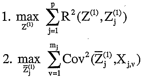
- Z (1) the first calculated synthetic variable, called Z (1) , calculated must be such that:
- R 2 is the multiple correlation coefficient and Z j (1) is the projection of Z (1) on the space S j normalized to 1.
- Rotation methods well known to those skilled in the art, can be implemented in each of the spaces thus found, in order to optimize the coefficients of correlations between the new variables and the initial variables.
- the first variable Z (1) is the standard eigenvector of the covariance matrix
- Z (1) is then projected onto the p spaces S j and, in each space, the regression of m. j variables by Z j (1) is calculated.
- the matrix of p juxtaposed residues X j (2) defines the new study space. This new space corresponds to the initial space from which the influence of Z j (1) was removed in each group S j .
- the m. j variables from table X j (2) define a subspace S j (2) of S j .
- the second component Z (2) is the standard eigenvector of the covariance matrix X (2) X (2) t D n of the residues corresponding to the largest eigenvalue.
- Z (2) is projected onto the p spaces S j (2) .
- the matrix XX ⁇ n being of order n, n being able to be very large
- the normal eigenvector N (k) of the matrix X (k) t D n X (k) is calculated at the highest eigenvalue.
- Each group can be reconstituted with a small number of attributes.
- the initial variables of group j can be expressed as the sum of a linear combination of variables Z j (k) and a residue. If all the variables Z j (k) of a group are used, the residue is zero.
- the coefficients of the linear combination are none other than the coefficients calculated at the end of each regression in the spaces S j .
- the method according to the invention has the property, among other things, that the variables Z (k) are orthogonal two by two.
- the correlations between the variables Z (k) and the initial variables X j , k are also calculated to highlight possible relationships between the X j , k . Correlations between variables Z j (k) and X j, k of the same group j, or correlations between variables Z j (k) for the same k can also be calculated.
- the new synthetic variables thus created constitute the new geophysical attributes sought.
- the method according to the invention was applied to three cubes of elastic properties (impedance P denoted Ip, impedance S denoted Is and specific mass denoted p) obtained after elastic inversion joined before summation using the method described in patent FR 2 800 47.3 already cited of seismic recordings grouped in cubes with angles of common incidence.
- Each elastic property generates a group of seismic variables or attributes.
- the analysis time window consists of 19 samples of signals taken from the seismic recordings.
- variable the elastic property values for a time sample inside the analysis window.
- Each group is then made up of 19 variables made up of as many individuals as there are available traces. Since there are three groups of variables, we have a total of 57 variables.
- the three parameter cubes were previously horizontalized with respect to a reference surface.
- Table 1 gives the proportion of percentage variance explained by the projections of the first 8 synthetic variables Z (1) to Z (8) in the three groups. It shows that 8 variables are enough to summarize 87.4% of the variance of the impedance P, 94.4% of the variance of the impedance S and 88.4% of the variance of the specific mass.
- This value indicates the degree of proximity between the variable and the group. The closer the value is to 1, the closer the variable is to its projection and therefore to the group.
- Z (1) is very close to Is and close to p, but very far from Ip.
- Z (2) is close to Ip, but very far from Is and p.
- Z () three are close to Ip alone, two are close to both Is and p, one is close to Is alone, and two are close to p alone.
- Ip and Is do not contain the same information and that part of the information contained in Is and in p seems common.
- the three elastic properties can be reconstructed with a limited number of new seismic attributes.
- the number of synthetic variables used for the reconstruction can be different from one group to another: it depends on the percentage of inertia that one wishes to reconstruct / filter.
- a first class corresponding to the wells Wl and W2 represent turbiditic sands
- a second class corresponding to well W3 represents turbiditic sludge
- a third class represents hemipelagites.
- the wells Wl and W2 showing close geological characteristics, only the seismic events located around the well W2 are used, the well Wl serving as a blind test.
- the location of well W3 being uncertain, the seismic events used to characterize class 2 are located around a virtual well defined near W3.
- a virtual well is defined from our general geological knowledge.
- Fig. 7 shows the geographic location of the three learning classes. Each class is made up of 121 seismic events (11x11). These events are used to calibrate a classification function which is then applied to all seismic events.
- Figs. 8A, 8B respectively show the assignments obtained and the most probable assignments, i.e. having an assignment probability greater than or equal to 80%.
- Well W1 used in blind test, is correctly assigned to the same class as well W2.
- Well W3 is located on the edge of classes 1 and 2.
- Class 2 is distributed along a channeling form. The map in Figure 8B shows that the results are stable: few events have a bad probability of allocation.
- the learning classes are formed using the modes of a multivariate probability density function calculated from the set of seismic events, in a space generated by the first eight new attributes.
- the higher probability density seismic events constituting the peaks of this density function are selected to carry out the learning of the classification function.
- This function is then applied to all the seismic events considered to assign them to one of the classes:
- Fig. 9A, 9B show the assignments obtained, as well as the most probable assignments, i.e. having an assignment probability greater than or equal to 80%.
- the maps obtained are very close to the maps in Figs. 8 A, 8B.
- Class 3 of supervised analysis corresponds to classes 3, 4 and 5 of unsupervised analysis.
- Wells W1 and W2 are assigned to the same class and well W3 is always located on the border between classes 3, and especially 1 and 2. This convergence of results validates the interpretation of the supervised approach.
Landscapes
- Engineering & Computer Science (AREA)
- Remote Sensing (AREA)
- Physics & Mathematics (AREA)
- Life Sciences & Earth Sciences (AREA)
- Acoustics & Sound (AREA)
- Environmental & Geological Engineering (AREA)
- Geology (AREA)
- General Life Sciences & Earth Sciences (AREA)
- General Physics & Mathematics (AREA)
- Geophysics (AREA)
- Geophysics And Detection Of Objects (AREA)
Abstract
Description



Claims
Priority Applications (5)
| Application Number | Priority Date | Filing Date | Title |
|---|---|---|---|
| AU2003274260A AU2003274260A1 (en) | 2002-09-10 | 2003-08-18 | Method for packing and filtering geophysical events to retrieve therefrom data on the type of subsoil |
| US10/527,082 US7289910B2 (en) | 2002-09-10 | 2003-08-18 | Method for packing and filtering geophysical events to retrieve therefrom data on the type of subsoil |
| CA2498029A CA2498029C (fr) | 2002-09-10 | 2003-08-18 | Methode pour compacter et filtrer des evenements geophysiques dans le but d'en extraire des informations sur la nature du sous-sol |
| EP03758244A EP1540377B1 (fr) | 2002-09-10 | 2003-08-18 | Methode pour compacter et filtrer des evenements geophysiques dans le but d en extraire des informations sur la nature du sou s-sol |
| NO20051007A NO336964B1 (no) | 2002-09-10 | 2005-02-24 | Komprimering og filtrering av geofysiske hendelser for å hente ut data om undergrunnen |
Applications Claiming Priority (4)
| Application Number | Priority Date | Filing Date | Title |
|---|---|---|---|
| FR02/11200 | 2002-09-10 | ||
| FR0211200A FR2844362B1 (fr) | 2002-09-10 | 2002-09-10 | Methode pour compacter et filtrer des evenements sismiques dans le but d'en extraire des informations sur la nature du sous-sol |
| FR0301900A FR2844363B1 (fr) | 2002-09-10 | 2003-02-17 | Methode pour compacter et filtrer des evenements geophysiques dans le but d'en extraire des informations sur la nature du sous-sol |
| FR03/01900 | 2003-02-17 |
Publications (1)
| Publication Number | Publication Date |
|---|---|
| WO2004025327A1 true WO2004025327A1 (fr) | 2004-03-25 |
Family
ID=31889636
Family Applications (1)
| Application Number | Title | Priority Date | Filing Date |
|---|---|---|---|
| PCT/FR2003/002543 Ceased WO2004025327A1 (fr) | 2002-09-10 | 2003-08-18 | Methode pour compacter et filtrer des evenements geophysiques dans le but d'en extraire des informations sur la nature du sous-sol |
Country Status (7)
| Country | Link |
|---|---|
| US (1) | US7289910B2 (fr) |
| EP (1) | EP1540377B1 (fr) |
| AU (1) | AU2003274260A1 (fr) |
| CA (1) | CA2498029C (fr) |
| FR (1) | FR2844363B1 (fr) |
| NO (1) | NO336964B1 (fr) |
| WO (1) | WO2004025327A1 (fr) |
Families Citing this family (3)
| Publication number | Priority date | Publication date | Assignee | Title |
|---|---|---|---|---|
| CA2767689C (fr) * | 2009-08-07 | 2018-01-02 | Exxonmobil Upstream Research Company | Systeme et procedes d'assistance au forage bases sur au moins deux parametres de forage maitrisables |
| US9702995B2 (en) | 2011-06-17 | 2017-07-11 | Exxonmobil Upstream Research Company | Domain freezing in joint inversion |
| CN112068221B (zh) * | 2020-09-07 | 2023-09-08 | 中国煤炭地质总局地球物理勘探研究院 | 一种煤层富水性分析方法 |
Citations (2)
| Publication number | Priority date | Publication date | Assignee | Title |
|---|---|---|---|---|
| US4937747A (en) * | 1988-02-16 | 1990-06-26 | Amoco Corporation | Iterative disjoint cluster and discriminant function processing of formation log responses and other data |
| US6052651A (en) * | 1997-09-22 | 2000-04-18 | Institute Francais Du Petrole | Statistical method of classifying events linked with the physical properties of a complex medium such as the subsoil |
-
2003
- 2003-02-17 FR FR0301900A patent/FR2844363B1/fr not_active Expired - Fee Related
- 2003-08-18 EP EP03758244A patent/EP1540377B1/fr not_active Expired - Lifetime
- 2003-08-18 CA CA2498029A patent/CA2498029C/fr not_active Expired - Fee Related
- 2003-08-18 WO PCT/FR2003/002543 patent/WO2004025327A1/fr not_active Ceased
- 2003-08-18 AU AU2003274260A patent/AU2003274260A1/en not_active Abandoned
- 2003-08-18 US US10/527,082 patent/US7289910B2/en not_active Expired - Fee Related
-
2005
- 2005-02-24 NO NO20051007A patent/NO336964B1/no not_active IP Right Cessation
Patent Citations (2)
| Publication number | Priority date | Publication date | Assignee | Title |
|---|---|---|---|---|
| US4937747A (en) * | 1988-02-16 | 1990-06-26 | Amoco Corporation | Iterative disjoint cluster and discriminant function processing of formation log responses and other data |
| US6052651A (en) * | 1997-09-22 | 2000-04-18 | Institute Francais Du Petrole | Statistical method of classifying events linked with the physical properties of a complex medium such as the subsoil |
Non-Patent Citations (1)
| Title |
|---|
| HUANG K-Y: "NEURAL NETWORKS FOR SEISMIC PRINCIPAL COMPONENTS ANALYSIS", IEEE TRANSACTIONS ON GEOSCIENCE AND REMOTE SENSING, IEEE INC. NEW YORK, US, vol. 37, no. 1, PART 1, January 1999 (1999-01-01), pages 297 - 311, XP000829042, ISSN: 0196-2892 * |
Also Published As
| Publication number | Publication date |
|---|---|
| FR2844363B1 (fr) | 2004-10-15 |
| US7289910B2 (en) | 2007-10-30 |
| FR2844363A1 (fr) | 2004-03-12 |
| EP1540377A1 (fr) | 2005-06-15 |
| EP1540377B1 (fr) | 2011-10-12 |
| US20060155470A1 (en) | 2006-07-13 |
| NO20051007D0 (no) | 2005-02-24 |
| CA2498029C (fr) | 2013-10-15 |
| CA2498029A1 (fr) | 2004-03-25 |
| NO336964B1 (no) | 2015-12-07 |
| AU2003274260A1 (en) | 2004-04-30 |
| NO20051007L (no) | 2005-06-09 |
Similar Documents
| Publication | Publication Date | Title |
|---|---|---|
| EP3023815B1 (fr) | Procédé de construction d'un modele geologique | |
| CA2324435C (fr) | Methode pour modeliser en 2d ou 3d un milieu heterogene tel que le sous-sol decrit par un ou plusieurs parametres physiques | |
| CA2670384C (fr) | Methode d'inversion conjointe de donnees sismiques representees sur des echelles de temps differentes | |
| EP3570074A1 (fr) | Procédé pour la détection d'objets géologiques dans une image | |
| FR2980897A1 (fr) | Procede de validation d'image d'entrainement pour la modelisation geostatistique multipoint du sous-sol | |
| FR2654515A1 (fr) | Methode d'evaluation lithologique a partir de donnees sismiques. | |
| EP1253443B1 (fr) | Méthode pour faciliter le suivi au cours du temps de l'évolution d'une zone souterraine par analyse comparée de differents jeux d'enregistrements sismiques | |
| EP0903592B1 (fr) | Méthode statistique de classement d'événements liés aux propriétés physiques d'un milieu complexe tel que le sous-sol | |
| Avants et al. | A new probe of ULVZ S‐wave velocity structure: Array stacking of ScS waveforms | |
| CA2456596C (fr) | Methode pour mesurer les similarites locales entre plusieurs cubes de traces sismiques | |
| CA2627766A1 (fr) | Methode d'evaluation quantitative des pressions de fluides et de detection des surpressions d'un milieu souterrain | |
| Folesky et al. | Stress drop variations in the region of the 2014 MW8. 1 Iquique earthquake, northern Chile | |
| FR2753800A1 (fr) | Procede et appareil pour exploiter des paires de donnees collectees au cours d'une operation sismique, lesquelles representent des caracteristiques d'une formation terrestre et pour generer un enregistrement de sortie | |
| Raji et al. | Wavefield analysis of crosswell seismic data | |
| EP1540377B1 (fr) | Methode pour compacter et filtrer des evenements geophysiques dans le but d en extraire des informations sur la nature du sou s-sol | |
| WO2016012191A1 (fr) | Procédé de filtrage adaptatif de reflexions sismiques multiples | |
| FR3132320A1 (fr) | Détection et correction de fausses classifications positives à partir d’un outil de détection de sable de produit | |
| Glangeaud et al. | Wave separation | |
| Bakulin et al. | Evaluating strategies for estimation of local kinematic parameters in noisy land data: quality versus performance trade-offs | |
| Chopra et al. | Processing/integration of simultaneously acquired 3D surface seismic and 3D VSP data | |
| Lu | Deep learning realm for geophysics: Seismic acquisition, processing, interpretation, and inversion | |
| Septyana et al. | Multi-channel waveform clustering: a first look at microseismic multiplets from coalbed methane stimulation | |
| FR2844362A1 (fr) | Methode pour compacter et filtrer des evenements sismiques dans le but d'en extraire des informations sur la nature du sous-sol | |
| EP0923051B1 (fr) | Méthode statistique multivariable pour caractériser des images que l'on à formées d'un milieu complexe tel que le sous-sol | |
| Molino‐Minero‐Re et al. | A method for classifying pre‐stack seismic data based on amplitude–frequency attributes and self‐organizing maps |
Legal Events
| Date | Code | Title | Description |
|---|---|---|---|
| AK | Designated states |
Kind code of ref document: A1 Designated state(s): AE AG AL AM AT AU AZ BA BB BG BR BY BZ CA CH CN CO CR CU CZ DE DK DM DZ EC EE ES FI GB GD GE GH GM HR HU ID IL IN IS JP KE KG KP KR KZ LC LK LR LS LT LU LV MA MD MG MK MN MW MX MZ NO NZ OM PH PL PT RO RU SC SD SE SG SK SL TJ TM TN TR TT TZ UA UG US UZ VC VN YU ZA ZM ZW |
|
| AL | Designated countries for regional patents |
Kind code of ref document: A1 Designated state(s): GH GM KE LS MW MZ SD SL SZ TZ UG ZM ZW AM AZ BY KG KZ MD RU TJ TM AT BE BG CH CY CZ DE DK EE ES FI FR GB GR HU IE IT LU MC NL PT RO SE SI SK TR BF BJ CF CG CI CM GA GN GQ GW ML MR NE SN TD TG |
|
| 121 | Ep: the epo has been informed by wipo that ep was designated in this application | ||
| WWE | Wipo information: entry into national phase |
Ref document number: 2003758244 Country of ref document: EP |
|
| WWE | Wipo information: entry into national phase |
Ref document number: 2498029 Country of ref document: CA |
|
| WWP | Wipo information: published in national office |
Ref document number: 2003758244 Country of ref document: EP |
|
| ENP | Entry into the national phase |
Ref document number: 2006155470 Country of ref document: US Kind code of ref document: A1 |
|
| WWE | Wipo information: entry into national phase |
Ref document number: 10527082 Country of ref document: US |
|
| WWP | Wipo information: published in national office |
Ref document number: 10527082 Country of ref document: US |
|
| NENP | Non-entry into the national phase |
Ref country code: JP |
|
| WWW | Wipo information: withdrawn in national office |
Country of ref document: JP |