WO2010064548A1 - 無人機及び無人機用空中見張りシステム - Google Patents
無人機及び無人機用空中見張りシステム Download PDFInfo
- Publication number
- WO2010064548A1 WO2010064548A1 PCT/JP2009/069723 JP2009069723W WO2010064548A1 WO 2010064548 A1 WO2010064548 A1 WO 2010064548A1 JP 2009069723 W JP2009069723 W JP 2009069723W WO 2010064548 A1 WO2010064548 A1 WO 2010064548A1
- Authority
- WO
- WIPO (PCT)
- Prior art keywords
- drone
- distance
- panoramic image
- azimuth angle
- camera
- Prior art date
- Legal status (The legal status is an assumption and is not a legal conclusion. Google has not performed a legal analysis and makes no representation as to the accuracy of the status listed.)
- Ceased
Links
Images




Classifications
-
- B—PERFORMING OPERATIONS; TRANSPORTING
- B64—AIRCRAFT; AVIATION; COSMONAUTICS
- B64U—UNMANNED AERIAL VEHICLES [UAV]; EQUIPMENT THEREFOR
- B64U20/00—Constructional aspects of UAVs
- B64U20/80—Arrangement of on-board electronics, e.g. avionics systems or wiring
-
- G—PHYSICS
- G01—MEASURING; TESTING
- G01S—RADIO DIRECTION-FINDING; RADIO NAVIGATION; DETERMINING DISTANCE OR VELOCITY BY USE OF RADIO WAVES; LOCATING OR PRESENCE-DETECTING BY USE OF THE REFLECTION OR RERADIATION OF RADIO WAVES; ANALOGOUS ARRANGEMENTS USING OTHER WAVES
- G01S17/00—Systems using the reflection or reradiation of electromagnetic waves other than radio waves, e.g. lidar systems
- G01S17/86—Combinations of lidar systems with systems other than lidar, radar or sonar, e.g. with direction finders
-
- G—PHYSICS
- G01—MEASURING; TESTING
- G01S—RADIO DIRECTION-FINDING; RADIO NAVIGATION; DETERMINING DISTANCE OR VELOCITY BY USE OF RADIO WAVES; LOCATING OR PRESENCE-DETECTING BY USE OF THE REFLECTION OR RERADIATION OF RADIO WAVES; ANALOGOUS ARRANGEMENTS USING OTHER WAVES
- G01S7/00—Details of systems according to groups G01S13/00, G01S15/00, G01S17/00
- G01S7/48—Details of systems according to groups G01S13/00, G01S15/00, G01S17/00 of systems according to group G01S17/00
- G01S7/481—Constructional features, e.g. arrangements of optical elements
- G01S7/4817—Constructional features, e.g. arrangements of optical elements relating to scanning
-
- G—PHYSICS
- G03—PHOTOGRAPHY; CINEMATOGRAPHY; ANALOGOUS TECHNIQUES USING WAVES OTHER THAN OPTICAL WAVES; ELECTROGRAPHY; HOLOGRAPHY
- G03B—APPARATUS OR ARRANGEMENTS FOR TAKING PHOTOGRAPHS OR FOR PROJECTING OR VIEWING THEM; APPARATUS OR ARRANGEMENTS EMPLOYING ANALOGOUS TECHNIQUES USING WAVES OTHER THAN OPTICAL WAVES; ACCESSORIES THEREFOR
- G03B13/00—Viewfinders; Focusing aids for cameras; Means for focusing for cameras; Autofocus systems for cameras
- G03B13/18—Focusing aids
- G03B13/20—Rangefinders coupled with focusing arrangements, e.g. adjustment of rangefinder automatically focusing camera
-
- G—PHYSICS
- G03—PHOTOGRAPHY; CINEMATOGRAPHY; ANALOGOUS TECHNIQUES USING WAVES OTHER THAN OPTICAL WAVES; ELECTROGRAPHY; HOLOGRAPHY
- G03B—APPARATUS OR ARRANGEMENTS FOR TAKING PHOTOGRAPHS OR FOR PROJECTING OR VIEWING THEM; APPARATUS OR ARRANGEMENTS EMPLOYING ANALOGOUS TECHNIQUES USING WAVES OTHER THAN OPTICAL WAVES; ACCESSORIES THEREFOR
- G03B37/00—Panoramic or wide-screen photography; Photographing extended surfaces, e.g. for surveying; Photographing internal surfaces, e.g. of pipe
- G03B37/04—Panoramic or wide-screen photography; Photographing extended surfaces, e.g. for surveying; Photographing internal surfaces, e.g. of pipe with cameras or projectors providing touching or overlapping fields of view
-
- H—ELECTRICITY
- H04—ELECTRIC COMMUNICATION TECHNIQUE
- H04N—PICTORIAL COMMUNICATION, e.g. TELEVISION
- H04N7/00—Television systems
- H04N7/18—Closed-circuit television [CCTV] systems, i.e. systems in which the video signal is not broadcast
- H04N7/183—Closed-circuit television [CCTV] systems, i.e. systems in which the video signal is not broadcast for receiving images from a single remote source
-
- B—PERFORMING OPERATIONS; TRANSPORTING
- B64—AIRCRAFT; AVIATION; COSMONAUTICS
- B64U—UNMANNED AERIAL VEHICLES [UAV]; EQUIPMENT THEREFOR
- B64U10/00—Type of UAV
- B64U10/25—Fixed-wing aircraft
-
- B—PERFORMING OPERATIONS; TRANSPORTING
- B64—AIRCRAFT; AVIATION; COSMONAUTICS
- B64U—UNMANNED AERIAL VEHICLES [UAV]; EQUIPMENT THEREFOR
- B64U2101/00—UAVs specially adapted for particular uses or applications
- B64U2101/30—UAVs specially adapted for particular uses or applications for imaging, photography or videography
- B64U2101/31—UAVs specially adapted for particular uses or applications for imaging, photography or videography for surveillance
-
- B—PERFORMING OPERATIONS; TRANSPORTING
- B64—AIRCRAFT; AVIATION; COSMONAUTICS
- B64U—UNMANNED AERIAL VEHICLES [UAV]; EQUIPMENT THEREFOR
- B64U2101/00—UAVs specially adapted for particular uses or applications
- B64U2101/70—UAVs specially adapted for particular uses or applications for use inside enclosed spaces, e.g. in buildings or in vehicles
Definitions
- the present invention relates to a drone, and more particularly to an aerial lookout for the drone.
- TCAS2 Traffic alert and Collation Aviation System 2
- TCAS2 Traffic alert and Collation Aviation System 2
- the aircraft equipped with TCAS2 makes an inquiry to other aircraft around and responds to the inquiry from the other aircraft. Based on these inquiries and responses, TCAS2 determines whether there are other aircraft around the aircraft that may cause an air collision, and informs the pilot of the presence of other aircraft that may cause an air collision. Warning. Turbine aircraft with a capacity of 19 or more are required to be equipped with TCAS2.
- US Pat. No. 5,581,250 discloses a technique for avoiding an aerial collision using a TV (television) camera that monitors the front of an unmanned aerial vehicle.
- a TV television
- two TV cameras are mounted on both wings of the drone facing forward, and the distance to the obstacle ahead of the drone is calculated based on images acquired by these TV cameras. Is done.
- DSA Radar-Development Report Presented at AUVSI 2005 June 26 to 30, 2005 uses the millimeter wave radar mounted in the vicinity of the drone's nose to determine the distance and direction to the aircraft in front of the drone A technique for detecting and avoiding air collision is disclosed. However, since the millimeter wave radar is heavy and requires a large amount of power, it is considered difficult to apply it to a small drone.
- An object of the present invention is to provide an unmanned aerial vehicle, an unmanned aerial lookout system for an unmanned aerial vehicle, and an aerial lookout method for the unmanned aerial vehicle, which can acquire relative position information of objects around the unmanned aerial vehicle with a small and lightweight device.
- the drone according to the first aspect of the present invention includes a camera, a laser ranging system that measures the distance to an object in the field of view of the camera, and a drive device that rotates the field of view.
- the relative position information of the object can be acquired with a small and lightweight device that does not use a millimeter wave radar.
- the driving device rotates a rotary optical system including a camera and a laser ranging system around a rotation axis.
- the laser ranging system can always measure the distance to the object in the field of view of the camera.
- the rotation axis is perpendicular to the axis direction and the left-right direction of the drone.
- the rotary optical system outputs a laser beam having a flat beam shape that is long in the direction of the rotation axis.
- Laser ranging systems measure the distance to an object based on a laser beam.
- the drone further includes a panoramic image information generation unit.
- the camera captures a plurality of images when the rotation optical system has a plurality of different rotation angles.
- the panorama image information generation unit generates panorama image information indicating a panorama image obtained by combining a plurality of images.
- the situation around the drone can be grasped at a glance.
- the drone further includes an azimuth angle detection unit.
- the panoramic image includes an image of an object.
- the azimuth angle detection unit detects the azimuth angle of the object based on the panoramic image information.
- the rotary optical system outputs a laser beam based on the azimuth angle and the rotation angle of the rotary optical system.
- Laser ranging systems measure the distance to an object based on a laser beam.
- the distance to the object can be reliably measured, and unnecessary laser beam emission can be prevented.
- the drone further includes an azimuth angle detection unit, a relative altitude calculation unit, a communication device, a flight control device, a control surface system, and a propulsion system.
- the panoramic image includes an image of an object.
- the azimuth angle detection unit detects the azimuth angle of the object based on the panoramic image information.
- the relative height calculation unit calculates the relative height of the object with respect to the drone based on the panoramic image information and the distance.
- the communication apparatus transmits panoramic image information, azimuth angle information indicating an azimuth angle, distance information indicating a distance, and relative altitude information indicating a relative altitude to the system outside the drone.
- the communication device receives a flight control command from the unmanned aerial vehicle system.
- the flight control device controls the control surface system or the propulsion system based on the flight control command.
- the drone can avoid an air collision with an object.
- An aerial lookout system for an unmanned aerial vehicle includes a camera, a laser ranging system that measures a distance to an object in the field of view of the camera, and a drive device that rotates the field of view.
- the aerial lookout method of the drone according to the third aspect of the present invention includes rotating the field of view of the camera and measuring the distance to the object in the field of view using a laser ranging system.
- the rotary optical system including the camera and the laser ranging system is rotated around the rotation axis.
- measuring the distance means that the rotating optical system outputs a laser beam having a flat beam shape that is long in the direction of the rotation axis, and that the laser ranging system determines the distance to the object based on the laser beam. Measuring.
- the aerial lookout method of the drone is configured to capture a plurality of images when the camera has a plurality of rotation angles different from each other and a panoramic image obtained by combining the plurality of images. Generating panoramic image information as shown.
- the panoramic image includes an object image.
- measuring the distance includes detecting an azimuth angle of the object based on the panoramic image information and outputting a laser beam based on the azimuth angle and the rotation angle of the rotary optical system.
- a laser ranging system measuring the distance to the object based on the laser beam.
- the panoramic image includes an object image.
- the aerial lookout method of the drone includes detecting an azimuth angle of the object based on the panoramic image information, calculating a relative altitude of the object with respect to the drone based on the panoramic image information and the distance, Send image information, azimuth information indicating azimuth, distance information indicating distance, and relative altitude information indicating relative altitude to the unmanned aerial system from this drone, and receive flight control commands from the unmanned aerial system And controlling the control surface or propulsion system of the drone based on the flight control command.
- an unmanned aerial vehicle an unmanned aerial look-out system for unmanned aircraft, and an aerial look-up method for the unmanned aircraft.
- FIG. 1 is a block diagram of a drone according to the first embodiment of the present invention.
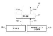
- FIG. 2 is a block diagram of the unmanned aerial vehicle system according to the first embodiment.
- FIG. 3 is an external view of the drone.
- FIG. 4 is a block diagram of the aerial lookout system according to the first embodiment.
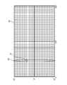
- FIG. 5 shows a panoramic image.
- FIG. 6 is a block diagram of a rotary optical system according to the second embodiment of the present invention.
- the drone 10 includes an aerial lookout system 20, a communication device 60, a flight control device 70, a control surface system 71, and a propulsion system 72. It has.
- the aerial lookout system 20 acquires aerial lookout information 105 including relative position information of flying objects present around the drone 10.
- the communication device 60 transmits the aerial lookout information 105 to an unmanned aerial system described later, and receives a flight control command 106 from the unmanned aerial system.
- the flight control device 70 controls the control surface 71 or the propulsion system 72 based on the flight control command 106.
- the unmanned aerial vehicle system 80 includes a communication device 81, a display device 82, and a flight control command generation device 83.
- the flight control command generation device 83 includes an input unit such as a control stick or a throttle lever.
- the communication device 81 receives the aerial lookout information 105 from the drone 10.
- the display device 82 displays the aerial lookout information 105.
- the pilot operates the input unit of the flight control command generation device 83 in order to cause the drone 10 to avoid a collision with a flying object.
- the flight control command generation device 83 generates the above-described flight control command 106 based on an operation by a pilot.
- the communication device 81 transmits the flight control command 106 to the drone 10.
- the unmanned aerial vehicle system 80 may be installed in a vehicle, a ship, or another aircraft in addition to being installed in a building.
- FIG. 3 shows the external appearance of the drone 10.
- the aerial lookout system 20 includes a rotary optical system 30A.
- the rotary optical system 30 ⁇ / b> A includes an outer cylinder 31 that protrudes upward from the nose 11 of the drone 10.
- the outer cylinder 31 has a cylindrical shape.
- the rotary optical system 30A rotates about the axis of rotation S1 of the drone 10 and the rotation axis S2 perpendicular to the left-right direction.
- the rotation axis S2 coincides with the central axis of the outer cylinder 31, for example.
- the aerial lookout system 20 includes a drive device 40 and a signal processing device 50 in addition to the rotary optical system 30A described above.
- the rotary optical system 30A includes a reflecting mirror 32, a beam splitter 33, a camera 34, and a laser ranging system 37 in addition to the outer cylinder 31 described above.
- the laser ranging system 37 emits and receives a laser beam 94 coaxially with the optical axis of the camera 34.
- the drive device 40 rotates the rotary optical system 30A around the rotation axis S2, and outputs rotation angle information 102 indicating the rotation angle of the rotary optical system 30A to the signal processing device 50.
- the driving device 40 continuously rotates the rotary optical system 30A in one direction.
- the outer cylinder 31, the reflecting mirror 32, the beam splitter 33, the camera 34, and the laser distance measuring system 37 rotate in the same body.
- the camera 34 includes a condenser lens 35 and a two-dimensional image sensor 36.
- the signal processing device 50 includes a panoramic image information generation unit 51, a flying object extraction unit 52, an azimuth angle detection unit 53, and a relative altitude calculation unit 54.
- the panoramic image information generation unit 51, the flying object extraction unit 52, the azimuth angle detection unit 53, and the relative altitude calculation unit 54 are realized by, for example, a computer that operates based on a computer program recorded on a recording medium.
- the camera 34 captures an image with respect to the visual field 93 via the reflecting mirror 32 and the beam splitter 33. Light from a point in the field 93 is reflected by the reflecting mirror 32, passes through the beam splitter 33 and the condenser lens 35, and reaches the two-dimensional image sensor 36. The camera 34 generates image information 101 indicating an image based on the light reaching the two-dimensional image sensor 36.
- the camera 34 is a TV (television) camera that generates image information 101 based on light in the visible light region, or an infrared camera that generates image information 101 based on light in the infrared region. When the camera 34 generates the image information 101 based on light in the visible light region, a look equivalent to a look by a pilot's eyes is provided.
- the visual field 93 has an extent of 2B in the vertical direction (direction of the rotation axis S2) and A degree in the horizontal direction (rotational circumferential direction around the rotation axis S2).
- the drive device 40 rotates the visual field 93 by rotating the rotary optical system 30A. Therefore, the camera 34 can image the front, rear, left and right of the drone 10.
- the laser ranging system 37 emits the laser beam 94 in response to the emission command 103 output from the signal processing device 50.
- the laser beam 94 is reflected by the beam splitter 33 and the reflecting mirror 32 and output from the rotary optical system 30A.
- the laser beam 94 output from the rotary optical system 30A travels in the visual field 93.
- the laser ranging system 37 measures (detects) the distance to the flying object based on the laser beam 94.
- the laser ranging system 37 outputs distance information 104 indicating the distance to the flying object to the signal processing device 50.
- the signal processing device 50 generates the aerial lookout information 105 based on the image information 101, the rotation angle information 102, and the distance information 104.
- the camera 34 captures a plurality of images when the rotation angle of the rotary optical system 30A is a plurality of rotation angles different from each other. For example, the camera 34 captures an image every time the rotation angle increases by C degrees, and generates image information 101 indicating the image. For example, C degree is a constant angle larger than 0 degree and smaller than A degree.
- the panorama image information generation unit 51 generates panorama image information indicating a panorama image in which a plurality of images are combined based on the image information 101 and the rotation angle information 102.
- the panoramic image 90 will be described with reference to FIG.
- the horizontal direction of the panoramic image 90 corresponds to 360 degrees around the rotation axis S2, and the vertical direction of the panoramic image 90 corresponds to a range of elevation angles from -B degrees to + B degrees.
- the elevation angle of an arbitrary point on a plane passing through the reflecting mirror 32 and perpendicular to the rotation axis S2 is 0 degree.
- the panoramic image 90 includes a flying object image 91 as an image of a flying object around the drone 10.
- the flying object extraction unit 52 performs image processing based on the panoramic image information and extracts the flying object image 91.
- the azimuth angle detection unit 53 detects the azimuth angle (angular position around the rotation axis S2) of the flying object based on the panoramic image information.
- the signal processing device 50 Based on the azimuth angle of the flying object and the rotation angle of the rotary optical system 30A indicated by the rotation angle information 102, the signal processing device 50 outputs a firing command 103 so that the laser beam 94 is output toward the flying object. .
- the laser ranging system 37 measures the distance to the flying object as described above. As a result, the distance to the flying object is reliably measured, and useless launch of the laser beam 94 is prevented.
- the relative altitude calculation unit 54 detects the elevation angle of the flying object based on the panoramic image information, and flies in a plane perpendicular to the rotation axis S2 through the reflector 32 based on the elevation angle of the flying object and the distance to the flying object. Calculate the signed length of a perpendicular drawn from the object.
- the elevation angle of the flying object is positive
- the length of the perpendicular has a positive sign
- the elevation angle of the flying object is negative
- the length of the perpendicular has a negative sign.
- the signed length of the perpendicular represents the relative altitude of the flying object with respect to the drone 10.
- the signal processing device 50 outputs the aerial lookout information 105 including the panoramic image information and the relative position information of the flying object to the communication device 60.
- the relative position information of the flying object includes azimuth angle information indicating the azimuth angle of the flying object, distance information indicating the distance to the flying object, and relative altitude information indicating the relative altitude (signed length of the vertical line) of the flying object. .
- the communication device 60 transmits the aerial lookout information 105 to the unmanned aerial vehicle system 80.
- the display device 82 displays the panoramic image 90 and the azimuth angle, distance, and relative altitude of the flying object based on the air lookout information 105.
- the panoramic image 90 is updated each time the rotary optical system 30A rotates once.
- the pilot operates the input unit of the flight control command generation device 83 in order to cause the drone 10 to avoid a collision with a flying object.
- the flight control command generation device 83 generates a flight control command 106 based on an operation by a pilot.
- the communication device 60 receives the flight control command 106 from the unmanned aerial vehicle system 80.
- the flight control device 70 controls the control surface 71 or the propulsion system 72 based on the flight control command 106.
- the laser beam 94 output from the rotary optical system 30A preferably has a flat beam shape that is long in the direction of the rotation axis S2.
- the laser beam irradiation field 92 of the laser beam 94 extends in an elevation angle range from ⁇ B degrees to + B degrees. Accordingly, as long as the flying object image 91 is included in the panoramic image 90, the flying object can be provided without providing a mechanism for swinging the direction in which the laser beam 94 is output from the rotary optical system 30A in the direction of the rotation axis S2. Can be measured.
- the rotary optical system 30A shapes the laser beam 94 into such a beam shape using an inverted kamaboko lens (cylindrical concave lens) (not shown).
- the unmanned aircraft 10 may avoid flying objects without depending on the unmanned aircraft outside system 80.
- the signal processing device 50 outputs the relative position information of the flying object to the flight control device 70.
- the flight control device 70 controls the control surface system 71 or the propulsion system 72 based on the relative position information of the flying object.
- the drone according to the second embodiment of the present invention With reference to FIG. 6, the drone according to the second embodiment of the present invention, the aerial lookout system for the drone and the aerial lookout method for the drone will be described.
- the drone, the aerial lookout system for the drone and the aerial lookout method for the unmanned aerial vehicle according to the present embodiment are related to the first embodiment except that the rotary optical system 30A is replaced with the rotary optical system 30B.
- the rotary optical system 30B includes the outer cylinder 31, the beam splitter 33, the camera 34, and the laser distance measuring system 37 as in the rotary optical system 30A, but does not include the reflecting mirror 32.
- the camera 34 captures an image with respect to the visual field 93 via the beam splitter 33. Light from a point in the field of view 93 passes through the beam splitter 33 and reaches the camera 34. The camera 34 generates image information 101 indicating an image based on the reached light.
- the laser beam 94 emitted by the laser ranging system 37 is reflected by the beam splitter 33 and output from the rotary optical system 30B.
- the laser beam 94 output from the rotary optical system 30B travels in the visual field 93.
- the laser ranging system 37 measures (detects) the distance to the flying object based on the laser beam 94.
- the laser ranging system 37 outputs distance information 104 indicating the distance to the flying object to the signal processing device 50.
- the portion of the outer cylinder 31 exposed from the trunk of the drone 10 becomes large, but the structure of the rotary optical system 30B becomes simple.
- the present invention has been described above with reference to the embodiment, the present invention is not limited to the above embodiment. Various modifications can be made to the above embodiment.
- the outer cylinder 31 may protrude downward from the nose 11 of the drone 10.
Landscapes
- Engineering & Computer Science (AREA)
- Physics & Mathematics (AREA)
- General Physics & Mathematics (AREA)
- Remote Sensing (AREA)
- Radar, Positioning & Navigation (AREA)
- Computer Networks & Wireless Communication (AREA)
- Electromagnetism (AREA)
- Multimedia (AREA)
- Signal Processing (AREA)
- Microelectronics & Electronic Packaging (AREA)
- Mechanical Engineering (AREA)
- Aviation & Aerospace Engineering (AREA)
- Optical Radar Systems And Details Thereof (AREA)
- Traffic Control Systems (AREA)
- Control Of Position, Course, Altitude, Or Attitude Of Moving Bodies (AREA)
Abstract
無人機は、カメラと、レーザ測距システムと、駆動装置とを具備する。レーザ測距システムは、カメラの視野にある物体までの距離を測定する。駆動装置は、視野を回転させる。無人機の周囲の物体の相対位置情報を小型軽量な装置で取得可能である。
Description
本発明は、無人機に関し、特に無人機の空中見張りに関する。
航空機どうしが空中衝突する危険を抑えるためのTCAS2(Traffic alert and Collision Avoidance System 2)が知られている。TCAS2を搭載した航空機は、周囲にいる他の航空機に問い合わせを行い、他の航空機からの問い合わせに応答する。このような問い合わせと応答に基づいて、TCAS2は自機の周囲に空中衝突の恐れのある他の航空機が存在するか判断し、空中衝突の恐れのある他の航空機の存在を自機のパイロットに警告する。定員19名以上のタービン航空機では、TCAS2の搭載が義務付けられている。
しかし、全ての航空機にTCAS2の搭載が義務付けられているわけではないため、TCAS2を搭載しない航空機との空中衝突の回避が問題となる。パイロットが搭乗する有人航空機においては、パイロットが目視で周囲を見張ることによりTCAS2を搭載しない航空機との空中衝突を回避することが可能である。無人航空機(無人機)は搭乗しないパイロットにより遠隔操縦されるため、目視による見張りに代替するシステムを無人機に搭載する必要がある。
米国特許第5581250号公報は、無人機の前方を監視するTV(television)カメラを用いて空中衝突を回避する技術を開示している。米国特許第5581250号公報によれば、無人機の両翼に2台のTVカメラを前方に向けて取り付け、これらのTVカメラが取得する画像に基づいて無人機の前方の障害物までの距離が演算される。しかし、翼のねじれ等の影響により必要な距離精度を確保することは困難であると考えられる。
“DSA Radar-Development Report” Presented at AUVSI 2005 June 26 to 30, 2005は、無人機の機首近傍に搭載されたミリ波レーダーを用いて無人機の前方に存在する航空機までの距離やその方位を検出し、空中衝突を回避する技術を開示している。しかし、ミリ波レーダーは重量及び所要電力が大きいため、小型の無人機に適用することは難しいと考えられる。
"DSA Radar-Development Report" Presented at AUVSI 2005 June 26 to 30, 2005
本発明の目的は、無人機の周囲の物体の相対位置情報を小型軽量な装置で取得可能な無人機、無人機用空中見張りシステム、及び無人機の空中見張り方法を提供することである。
本発明の第1の観点による無人機は、カメラと、カメラの視野にある物体までの距離を測定するレーザ測距システムと、視野を回転させる駆動装置とを具備する。
したがって、ミリ波レーダーを用いない小型軽量な装置で物体の相対位置情報を取得可能である。
好ましくは、駆動装置は、カメラ及びレーザ測距システムを含む回転式光学系を回転軸まわりに回転させる。
したがって、レーザ測距システムは、常にカメラの視野にある物体までの距離を測定可能である。
好ましくは、回転軸は、本無人機の機軸方向及び左右方向に垂直である。
したがって、本無人機の前後左右を見張ることが可能である。
好ましくは、回転式光学系は、回転軸の方向に長い扁平なビーム形状を有するレーザービームを出力する。レーザ測距システムは、レーザービームに基づいて物体までの距離を測定する。
したがって、レーザービームが回転式光学系から出力される方向を回転軸の方向に首振りさせる機構を設ける必要がない。
好ましくは、無人機は、パノラマ画像情報生成部を更に具備する。カメラは、回転式光学系の回転角が互いに異なる複数の回転角のときに複数の画像をそれぞれ撮像する。パノラマ画像情報生成部は、複数の画像が結合されたパノラマ画像を示すパノラマ画像情報を生成する。
パノラマ画像によれば、無人機の周囲の状況が一目で把握可能である。
好ましくは、無人機は、方位角検出部を更に具備する。パノラマ画像は物体の像を含む。方位角検出部は、パノラマ画像情報に基づいて物体の方位角を検出する。回転式光学系は、方位角及び回転式光学系の回転角に基づいてレーザービームを出力する。レーザ測距システムは、レーザービームに基づいて物体までの距離を測定する。
したがって、物体までの距離が確実に測定され、且つ、レーザービームの無駄な発射が防がれる。
好ましくは、無人機は、方位角検出部と、相対高度演算部と、通信装置と、飛行制御装置と、操縦舵面系統と、推進系統とを更に具備する。パノラマ画像は物体の像を含む。方位角検出部は、パノラマ画像情報に基づいて物体の方位角を検出する。相対高度演算部は、パノラマ画像情報及び距離に基づいて本無人機に対する物体の相対高度を演算する。通信装置は、パノラマ画像情報、方位角を示す方位角情報、距離を示す距離情報、及び相対高度を示す相対高度情報を無人機外システムに送信する。通信装置は、無人機外システムから飛行制御コマンドを受信する。飛行制御装置は、飛行制御コマンドに基づいて操縦舵面系統又は推進系統を制御する。
したがって、無人機は、物体との空中衝突を回避することができる。
本発明の第2の観点による無人機用空中見張りシステムは、カメラと、カメラの視野にある物体までの距離を測定するレーザ測距システムと、視野を回転させる駆動装置とを具備する。
本発明の第3の観点による無人機の空中見張り方法は、カメラの視野を回転させることと、レーザ測距システムを用いて視野にある物体までの距離を測定することとを具備する。
好ましくは、カメラの視野を回転させることにおいて、カメラ及びレーザ測距システムを含む回転式光学系を回転軸まわりに回転させる。
好ましくは、距離を測定することは、回転軸の方向に長い扁平なビーム形状を有するレーザービームを回転式光学系が出力することと、レーザ測距システムがレーザービームに基づいて物体までの距離を測定することとを含む。
好ましくは、無人機の空中見張り方法は、カメラが回転式光学系の回転角が互いに異なる複数の回転角のときに複数の画像をそれぞれ撮像することと、複数の画像が結合されたパノラマ画像を示すパノラマ画像情報を生成することとを更に具備する。
パノラマ画像は物体の像を含む。好ましくは、距離を測定することは、パノラマ画像情報に基づいて物体の方位角を検出することと、回転式光学系が方位角及び回転式光学系の回転角に基づいてレーザービームを出力することと、レーザ測距システムがレーザービームに基づいて物体までの距離を測定することとを含む。
パノラマ画像は物体の像を含む。好ましくは、無人機の空中見張り方法は、パノラマ画像情報に基づいて物体の方位角を検出することと、パノラマ画像情報及び距離に基づいて本無人機に対する物体の相対高度を演算することと、パノラマ画像情報、方位角を示す方位角情報、距離を示す距離情報、及び相対高度を示す相対高度情報を本無人機から無人機外システムに送信することと、無人機外システムから飛行制御コマンドを受信することと、飛行制御コマンドに基づいて本無人機の操縦舵面系統又は推進系統を制御することとを更に具備する。
本発明によれば、無人機の周囲の物体の相対位置情報を小型軽量な装置で取得可能な無人機、無人機用空中見張りシステム、及び無人機の空中見張り方法が提供される。
本発明の上記目的、他の目的、効果、及び特徴は、添付される図面と連携して実施の形態の記述から、より明らかになる。
添付図面を参照して、本発明による無人機、無人機用空中見張りシステム、及び無人機の空中見張り方法を実施するための形態を以下に説明する。
(第1の実施形態)
図1を参照して、本発明の第1の実施形態に係る無人機10は、空中見張りシステム20と、通信装置60と、飛行制御装置70と、操縦舵面系統71と、推進系統72を具備する。空中見張りシステム20は、無人機10の周囲に存在する飛行物体の相対位置情報を含む空中見張り情報105を取得する。通信装置60は、空中見張り情報105を後述する無人機外システムに送信し、無人機外システムから飛行制御コマンド106を受信する。飛行制御装置70は、飛行制御コマンド106に基づいて操縦舵面系統71又は推進系統72を制御する。
図1を参照して、本発明の第1の実施形態に係る無人機10は、空中見張りシステム20と、通信装置60と、飛行制御装置70と、操縦舵面系統71と、推進系統72を具備する。空中見張りシステム20は、無人機10の周囲に存在する飛行物体の相対位置情報を含む空中見張り情報105を取得する。通信装置60は、空中見張り情報105を後述する無人機外システムに送信し、無人機外システムから飛行制御コマンド106を受信する。飛行制御装置70は、飛行制御コマンド106に基づいて操縦舵面系統71又は推進系統72を制御する。
図2を参照して、無人機外システム80は、通信装置81と、表示装置82と、飛行制御コマンド生成装置83を備える。飛行制御コマンド生成装置83は、操縦桿やスロットルレバーのような入力部を備える。通信装置81は、無人機10から空中見張り情報105を受信する。表示装置82は、空中見張り情報105を表示する。パイロットは、表示装置82の表示に基づいて、無人機10に飛行物体との衝突を回避させるため、飛行制御コマンド生成装置83の入力部を操作する。飛行制御コマンド生成装置83は、パイロットによる操作に基づいて上述の飛行制御コマンド106を生成する。通信装置81は、飛行制御コマンド106を無人機10に送信する。なお、無人機外システム80は、建物に設置されるほか、車両、船舶、又は他の航空機に搭載されてもよい。
図3は、無人機10の外観を示している。空中見張りシステム20は、回転式光学系30Aを備える。回転式光学系30Aは、無人機10の機首11から機体上方に突き出した外筒31を備える。外筒31は円筒形状を有する。回転式光学系30Aは、無人機10の機軸方向S1及び左右方向に垂直な回転軸S2まわりに回転する。回転軸S2は、例えば、外筒31の中心軸に一致する。
図4を参照して、空中見張りシステム20を説明する。空中見張りシステム20は、上述の回転式光学系30Aに加えて、駆動装置40と、信号処理装置50を備える。回転式光学系30Aは、上述の外筒31に加えて、反射鏡32と、ビームスプリッタ33と、カメラ34と、レーザ測距システム37を備える。レーザ測距システム37は、カメラ34の光学軸と同軸にレーザービーム94を発光及び受光する。駆動装置40は、回転式光学系30Aを回転軸S2まわりに回転させ、回転式光学系30Aの回転角を示す回転角情報102を信号処理装置50へ出力する。駆動装置40は、回転式光学系30Aを連続的に一方向に回転させる。外筒31、反射鏡32、ビームスプリッタ33、カメラ34、及びレーザ測距システム37は同体に回転する。カメラ34は、集光レンズ35と二次元画像センサ36を備える。信号処理装置50は、パノラマ画像情報生成部51と、飛行物体抽出部52と、方位角検出部53と、相対高度演算部54を備える。パノラマ画像情報生成部51、飛行物体抽出部52、方位角検出部53、及び相対高度演算部54は、例えば、記録媒体に記録されたコンピュータプログラムに基づいて動作するコンピュータによって実現される。
カメラ34は、反射鏡32及びビームスプリッタ33を介して、視野93について画像を撮像する。視野93内の点からの光は、反射鏡32で反射し、ビームスプリッタ33及び集光レンズ35を透過して、二次元画像センサ36に到達する。カメラ34は、二次元画像センサ36に到達した光に基づいて、画像を示す画像情報101を生成する。カメラ34は、可視光領域の光に基づいて画像情報101を生成するTV(television)カメラ、又は、赤外線領域の光に基づいて画像情報101を生成する赤外線カメラである。カメラ34が可視光領域の光に基づいて画像情報101を生成する場合、パイロットの目視による見張りと同等の見張りが提供される。カメラ34が赤外線カメラである場合、空中見張りシステム20は夜間でも有効である。視野93は、縦方向(回転軸S2の方向)に2B度、横方向(回転軸S2まわりの回転周方向)にA度の広がりを有している。駆動装置40は、回転式光学系30Aを回転させることで視野93を回転させる。したがって、カメラ34は無人機10の前後左右を撮像可能である。
レーザ測距システム37は、信号処理装置50が出力する発射コマンド103に応答してレーザービーム94を発射する。レーザービーム94は、ビームスプリッタ33及び反射鏡32で反射して、回転式光学系30Aから出力される。回転式光学系30Aから出力されたレーザービーム94は、視野93内を進む。レーザービーム94は、視野93内の飛行物体で反射すると、反射鏡32及びビームスプリッタ33で反射してレーザ測距システム37に到達する。レーザ測距システム37は、レーザービーム94に基づいて飛行物体までの距離を測定(検出)する。レーザ測距システム37は、飛行物体までの距離を示す距離情報104を信号処理装置50に出力する。信号処理装置50は、画像情報101、回転角情報102、及び距離情報104に基づいて空中見張り情報105を生成する。
以下、本実施形態に係る無人機の空中見張り方法を説明する。
カメラ34は、回転式光学系30Aの回転角が互いに異なる複数の回転角のときに複数の画像をそれぞれ撮像する。例えば、カメラ34は、回転角がC度増加するごとに画像を撮像し、画像を示す画像情報101を生成する。例えば、C度は0度より大きくA度より小さい一定角度である。パノラマ画像情報生成部51は、画像情報101及び回転角情報102に基づいて、複数の画像が結合されたパノラマ画像を示すパノラマ画像情報を生成する。
図5を用いて、パノラマ画像90を説明する。パノラマ画像90の横方向は回転軸S2の周囲360度に対応し、パノラマ画像90の縦方向は仰角が-B度から+B度の範囲に対応する。ここで、反射鏡32を通り回転軸S2に垂直な平面上の任意の点の仰角は0度である。パノラマ画像90は、無人機10の周囲の飛行物体の像としての飛行物体像91を含む。
飛行物体抽出部52は、パノラマ画像情報に基づいて画像処理を実行し、飛行物体像91を抽出する。方位角検出部53は、パノラマ画像情報に基づいて飛行物体の方位角(回転軸S2まわりの角度位置)を検出する。
信号処理装置50は、飛行物体の方位角と回転角情報102が示す回転式光学系30Aの回転角に基づいて、飛行物体に向かってレーザービーム94が出力されるように発射コマンド103を出力する。レーザ測距システム37は、発射コマンド103に応答して、上述のように飛行物体までの距離を測定する。これにより、飛行物体までの距離が確実に測定され、且つ、レーザービーム94の無駄な発射が防がれる。
相対高度演算部54は、パノラマ画像情報に基づいて飛行物体の仰角を検出し、飛行物体の仰角と飛行物体までの距離とに基づいて、反射鏡32を通り回転軸S2に垂直な平面に飛行物体からおろした垂線の符号付き長さを演算する。ここで、飛行物体の仰角が正であるとき垂線の長さは正の符号を有し、飛行物体の仰角が負であるとき垂線の長さは負の符号を有する。無人機10が水平飛行中の場合、垂線の符号付き長さは飛行物体の無人機10に対する相対高度を表す。
信号処理装置50は、パノラマ画像情報と飛行物体の相対位置情報とを含む空中見張り情報105を通信装置60に出力する。飛行物体の相対位置情報は、飛行物体の方位角を示す方位角情報、飛行物体までの距離を示す距離情報、及び飛行物体の相対高度(垂線の符号付き長さ)を示す相対高度情報を含む。
通信装置60は空中見張り情報105を無人機外システム80に送信する。表示装置82は、空中見張り情報105に基づいて、パノラマ画像90、並びに、飛行物体の方位角、距離及び相対高度を表示する。パノラマ画像90は、回転式光学系30Aが一回転するごとに更新される。パイロットは、表示装置82の表示に基づいて、無人機10に飛行物体との衝突を回避させるため、飛行制御コマンド生成装置83の入力部を操作する。飛行制御コマンド生成装置83は、パイロットによる操作に基づいて飛行制御コマンド106を生成する。通信装置60は、無人機外システム80から飛行制御コマンド106を受信する。飛行制御装置70は、飛行制御コマンド106に基づいて操縦舵面系統71又は推進系統72を制御する。
本実施形態において、回転式光学系30Aから出力されるレーザービーム94は、回転軸S2の方向に長い扁平なビーム形状を有することが好ましい。この場合、図5に示すように、レーザービーム94のレーザービーム照射野92は、仰角が-B度から+B度の範囲に広がる。したがって、飛行物体像91がパノラマ画像90に含まれてさえいれば、レーザービーム94が回転式光学系30Aから出力される方向を回転軸S2の方向に首振りさせる機構を設けなくても飛行物体までの距離を測定することが可能である。例えば回転式光学系30Aは、図示されない逆かまぼこ型レンズ(円柱凹レンズ)を用いてレーザービーム94をこのようなビーム形状に成形する。
また、本実施形態において、無人機10が無人機外システム80に依存しないで飛行物体を回避してもよい。この場合、信号処理装置50は、飛行物体の相対位置情報を飛行制御装置70に出力する。飛行制御装置70は、飛行物体の相対位置情報に基づいて操縦舵面系統71又は推進系統72を制御する。
(第2の実施形態)
図6を参照して、本発明の第2の実施形態に係る無人機、無人機用空中見張りシステム及び無人機の空中見張り方法を説明する。本実施形態に係る無人機、無人機用空中見張りシステム及び無人機の空中見張り方法は、回転式光学系30Aが回転式光学系30Bで置き換えられていることを除いて第1の実施形態に係る無人機、無人機用空中見張りシステム及び無人機の空中見張り方法と同じである。
図6を参照して、本発明の第2の実施形態に係る無人機、無人機用空中見張りシステム及び無人機の空中見張り方法を説明する。本実施形態に係る無人機、無人機用空中見張りシステム及び無人機の空中見張り方法は、回転式光学系30Aが回転式光学系30Bで置き換えられていることを除いて第1の実施形態に係る無人機、無人機用空中見張りシステム及び無人機の空中見張り方法と同じである。
回転式光学系30Bは、回転式光学系30Aと同様に外筒31、ビームスプリッタ33、カメラ34、及びレーザ測距システム37を備えるが、反射鏡32を備えない。カメラ34は、ビームスプリッタ33を介して、視野93について画像を撮像する。視野93内の点からの光は、ビームスプリッタ33を透過してカメラ34に到達する。カメラ34は、到達した光に基づいて、画像を示す画像情報101を生成する。レーザ測距システム37が発射したレーザービーム94は、ビームスプリッタ33で反射して、回転式光学系30Bから出力される。回転式光学系30Bから出力されたレーザービーム94は、視野93内を進む。レーザービーム94は、視野93内の飛行物体で反射すると、ビームスプリッタ33で反射してレーザ測距システム37に到達する。レーザ測距システム37は、レーザービーム94に基づいて飛行物体までの距離を測定(検出)する。レーザ測距システム37は、飛行物体までの距離を示す距離情報104を信号処理装置50に出力する。
本実施形態によれば、外筒31の無人機10の胴体から露出している部分が大きくなるが、回転式光学系30Bの構造が単純になる。
以上、実施の形態を参照して本発明を説明したが、本発明は上記実施の形態に限定されるものではない。上記実施の形態に様々な変更を行うことが可能である。例えば、上記各実施形態においては、外筒31が無人機10の機首11から機体下方に突き出していてもよい。
この出願は、2008年12月3日に出願された日本出願特願2008-309123号を基礎とする優先権を主張し、その開示の全てをここに取り込む。
Claims (14)
- カメラと、
前記カメラの視野にある物体までの距離を測定するレーザ測距システムと、
前記視野を回転させる駆動装置と
を具備する
無人機。 - 前記駆動装置は、前記カメラ及び前記レーザ測距システムを含む回転式光学系を回転軸まわりに回転させる
請求の範囲1の無人機。 - 前記回転軸は、本無人機の機軸方向及び左右方向に垂直である
請求の範囲2の無人機。 - 前記回転式光学系は、前記回転軸の方向に長い扁平なビーム形状を有するレーザービームを出力し、
前記レーザ測距システムは、前記レーザービームに基づいて前記物体までの前記距離を測定する
請求の範囲2又は3の無人機。 - パノラマ画像情報生成部を更に具備し、
前記カメラは、前記回転式光学系の回転角が互いに異なる複数の回転角のときに複数の画像をそれぞれ撮像し、
前記パノラマ画像情報生成部は、前記複数の画像が結合されたパノラマ画像を示すパノラマ画像情報を生成する
請求の範囲2乃至4のいずれかに記載の無人機。 - 方位角検出部を更に具備し、
前記パノラマ画像は前記物体の像を含み、
前記方位角検出部は、前記パノラマ画像情報に基づいて前記物体の方位角を検出し、
前記回転式光学系は、前記方位角及び前記回転式光学系の回転角に基づいてレーザービームを出力し、
前記レーザ測距システムは、前記レーザービームに基づいて前記物体までの前記距離を測定する
請求の範囲5の無人機。 - 方位角検出部と、
相対高度演算部と、
通信装置と、
飛行制御装置と、
操縦舵面系統と、
推進系統と
を更に具備し、
前記パノラマ画像は前記物体の像を含み、
前記方位角検出部は、前記パノラマ画像情報に基づいて前記物体の方位角を検出し、
前記相対高度演算部は、前記パノラマ画像情報及び前記距離に基づいて本無人機に対する前記物体の相対高度を演算し、
前記通信装置は、前記パノラマ画像情報、前記方位角を示す方位角情報、前記距離を示す距離情報、及び前記相対高度を示す相対高度情報を無人機外システムに送信し、
前記通信装置は、前記無人機外システムから飛行制御コマンドを受信し、
前記飛行制御装置は、前記飛行制御コマンドに基づいて前記操縦舵面系統又は前記推進系統を制御する
請求の範囲5の無人機。 - カメラと、
前記カメラの視野にある物体までの距離を測定するレーザ測距システムと、
前記視野を回転させる駆動装置と
を具備する
無人機用空中見張りシステム。 - カメラの視野を回転させることと、
レーザ測距システムを用いて前記視野にある物体までの距離を測定することと
を具備する
無人機の空中見張り方法。 - 前記カメラの視野を回転させることにおいて、前記カメラ及び前記レーザ測距システムを含む回転式光学系を回転軸まわりに回転させる
請求の範囲9の無人機の空中見張り方法。 - 前記距離を測定することは、
前記回転軸の方向に長い扁平なビーム形状を有するレーザービームを前記回転式光学系が出力することと、
前記レーザ測距システムが前記レーザービームに基づいて前記物体までの前記距離を測定することと
を含む
請求の範囲10の無人機の空中見張り方法。 - 前記カメラが前記回転式光学系の回転角が互いに異なる複数の回転角のときに複数の画像をそれぞれ撮像することと、
前記複数の画像が結合されたパノラマ画像を示すパノラマ画像情報を生成することと
を更に具備する
請求の範囲10又は11の無人機の空中見張り方法。 - 前記パノラマ画像は前記物体の像を含み、
前記距離を測定することは、
前記パノラマ画像情報に基づいて前記物体の方位角を検出することと、
前記回転式光学系が前記方位角及び前記回転式光学系の回転角に基づいてレーザービームを出力することと、
前記レーザ測距システムが前記レーザービームに基づいて前記物体までの前記距離を測定することと
を含む
請求の範囲12の無人機の空中見張り方法。 - 前記パノラマ画像は前記物体の像を含み、
前記パノラマ画像情報に基づいて前記物体の方位角を検出することと、
前記パノラマ画像情報及び前記距離に基づいて本無人機に対する前記物体の相対高度を演算することと、
前記パノラマ画像情報、前記方位角を示す方位角情報、前記距離を示す距離情報、及び前記相対高度を示す相対高度情報を本無人機から無人機外システムに送信することと、
前記無人機外システムから飛行制御コマンドを受信することと、
前記飛行制御コマンドに基づいて本無人機の操縦舵面系統又は推進系統を制御することと
を更に具備する
請求の範囲12の無人機の空中見張り方法。
Priority Applications (3)
| Application Number | Priority Date | Filing Date | Title |
|---|---|---|---|
| EP09830315.9A EP2353999B1 (en) | 2008-12-03 | 2009-11-20 | Unmanned aircraft and aerial surveillance system for unmanned aircraft |
| US13/058,566 US8676408B2 (en) | 2008-12-03 | 2009-11-20 | Unmanned aircraft and aerial surveillance system for unmanned aircraft |
| IL211127A IL211127A (en) | 2008-12-03 | 2011-02-08 | Unmanned Aircraft and Air Control System for Unmanned Aircraft |
Applications Claiming Priority (2)
| Application Number | Priority Date | Filing Date | Title |
|---|---|---|---|
| JP2008-309123 | 2008-12-03 | ||
| JP2008309123A JP5101474B2 (ja) | 2008-12-03 | 2008-12-03 | 無人機及び無人機用空中見張りシステム |
Publications (1)
| Publication Number | Publication Date |
|---|---|
| WO2010064548A1 true WO2010064548A1 (ja) | 2010-06-10 |
Family
ID=42233199
Family Applications (1)
| Application Number | Title | Priority Date | Filing Date |
|---|---|---|---|
| PCT/JP2009/069723 Ceased WO2010064548A1 (ja) | 2008-12-03 | 2009-11-20 | 無人機及び無人機用空中見張りシステム |
Country Status (5)
| Country | Link |
|---|---|
| US (1) | US8676408B2 (ja) |
| EP (1) | EP2353999B1 (ja) |
| JP (1) | JP5101474B2 (ja) |
| IL (1) | IL211127A (ja) |
| WO (1) | WO2010064548A1 (ja) |
Cited By (6)
| Publication number | Priority date | Publication date | Assignee | Title |
|---|---|---|---|---|
| US20140092206A1 (en) * | 2011-04-01 | 2014-04-03 | Latecoere | Aircraft provided with a system for observing part of the aircraft's environment |
| US9629076B2 (en) | 2014-11-20 | 2017-04-18 | At&T Intellectual Property I, L.P. | Network edge based access network discovery and selection |
| US9655034B2 (en) | 2014-10-31 | 2017-05-16 | At&T Intellectual Property I, L.P. | Transaction sensitive access network discovery and selection |
| US10162351B2 (en) | 2015-06-05 | 2018-12-25 | At&T Intellectual Property I, L.P. | Remote provisioning of a drone resource |
| US10470241B2 (en) | 2016-11-15 | 2019-11-05 | At&T Intellectual Property I, L.P. | Multiple mesh drone communication |
| US11039002B2 (en) | 2015-06-05 | 2021-06-15 | At&T Intellectual Property I, L.P. | Context sensitive communication augmentation |
Families Citing this family (26)
| Publication number | Priority date | Publication date | Assignee | Title |
|---|---|---|---|---|
| US8687062B1 (en) * | 2011-08-31 | 2014-04-01 | Google Inc. | Step-stare oblique aerial camera system |
| JP5888669B2 (ja) * | 2011-10-03 | 2016-03-22 | 国立研究開発法人宇宙航空研究開発機構 | 航空機搭載レーザ装置から放射されたレーザ光を所望方向に反射させる方法及びその装置 |
| JP6001914B2 (ja) * | 2012-05-10 | 2016-10-05 | 川崎重工業株式会社 | 目標位置特定装置、目標位置特定システム、および目標位置特定方法 |
| US9022322B2 (en) | 2013-03-15 | 2015-05-05 | Curnell Melvin Westbrook, SR. | Remotely-controlled emergency aerial vehicle |
| KR101501528B1 (ko) * | 2013-10-01 | 2015-03-11 | 재단법인대구경북과학기술원 | 무인항공기 충돌 방지 시스템 및 방법 |
| SG11201609575PA (en) * | 2014-04-22 | 2016-12-29 | Skyrobot Inc | Solar power panel failure detection and searching system |
| US20150330054A1 (en) * | 2014-05-16 | 2015-11-19 | Topcon Positioning Systems, Inc. | Optical Sensing a Distance from a Range Sensing Apparatus and Method |
| JP6667943B2 (ja) * | 2014-10-17 | 2020-03-18 | 日本無線株式会社 | 画像生成装置 |
| WO2016122744A2 (en) | 2014-11-11 | 2016-08-04 | Sikorsky Aircraft Corporation | Trajectory-based sensor planning |
| US9761147B2 (en) | 2014-12-12 | 2017-09-12 | Amazon Technologies, Inc. | Commercial and general aircraft avoidance using light pattern detection |
| EP3567568A1 (en) * | 2014-12-12 | 2019-11-13 | Amazon Technologies Inc. | Commercial and general aircraft avoidance using light, sound, and/or multi-spectral pattern detection |
| US9685089B2 (en) | 2014-12-12 | 2017-06-20 | Amazon Technologies, Inc. | Commercial and general aircraft avoidance using acoustic pattern recognition |
| US9997079B2 (en) | 2014-12-12 | 2018-06-12 | Amazon Technologies, Inc. | Commercial and general aircraft avoidance using multi-spectral wave detection |
| US10683086B2 (en) | 2015-03-19 | 2020-06-16 | Prodrone Co., Ltd. | Unmanned rotorcraft and method for measuring circumjacent object around rotorcraft |
| CN112034827B (zh) * | 2015-09-04 | 2024-03-29 | 松下电器(美国)知识产权公司 | 通知方法和通知装置 |
| US10367447B2 (en) * | 2015-12-16 | 2019-07-30 | Skycom Corporation | Lighter-than-air aircraft and method to reduce leakage within a flexible bladder |
| KR20170084966A (ko) * | 2016-01-13 | 2017-07-21 | 주식회사 이지시스 | 국소위치인식시스템 |
| FR3048805A1 (fr) * | 2016-03-08 | 2017-09-15 | Airbus Operations Sas | Procede et dispositif d’evitement de collision pour une formation d’aeronefs par rapport a un aeronef intrus. |
| FR3069948B1 (fr) | 2017-08-03 | 2020-04-10 | Airbus Operations | Procede et dispositif de controle de la trajectoire d'un aeronef suiveur par rapport a un aeronef meneur lors d'un risque de collision. |
| CN113794840B (zh) * | 2017-09-29 | 2023-05-19 | 深圳市大疆创新科技有限公司 | 一种视频处理方法、设备、无人机及系统 |
| FR3079942B1 (fr) | 2018-04-04 | 2021-02-26 | Airbus Operations Sas | Procede et dispositif de determination de trajectoire vers une position optimale d'un aeronef suiveur par rapport a des vortex generes par un aeronef meneur |
| JP7303658B2 (ja) * | 2019-04-24 | 2023-07-05 | 株式会社トプコン | 赤外線写真画像の処理方法、赤外線写真画像の処理装置、および赤外線写真画像の処理用プログラム |
| CN114375276B (zh) * | 2019-10-09 | 2024-12-24 | 小鹰公司 | 具有前掠翼的短距起降载具 |
| CN112484692B (zh) * | 2020-11-05 | 2023-01-03 | 江西洪都航空工业集团有限责任公司 | 一种飞行器与云层相对高度视觉检测方法和装置 |
| US12145753B2 (en) * | 2022-08-09 | 2024-11-19 | Pete Bitar | Compact and lightweight drone delivery device called an ArcSpear electric jet drone system having an electric ducted air propulsion system and being relatively difficult to track in flight |
| WO2025215560A1 (en) * | 2024-04-09 | 2025-10-16 | Grindstone Technologies Llc | System and method for providing aircraft navigational aid |
Citations (5)
| Publication number | Priority date | Publication date | Assignee | Title |
|---|---|---|---|---|
| JPH03213498A (ja) * | 1989-12-01 | 1991-09-18 | Thomson Csf | 空中攻撃及び航行任務を補佐するオプトエレクトロニクスシステム |
| US5581250A (en) | 1995-02-24 | 1996-12-03 | Khvilivitzky; Alexander | Visual collision avoidance system for unmanned aerial vehicles |
| JP2004156944A (ja) * | 2002-11-05 | 2004-06-03 | Toshiba Corp | 捜索システムおよび捜索方法 |
| JP2005037186A (ja) * | 2003-07-17 | 2005-02-10 | Tamagawa Seiki Co Ltd | 空間安定装置 |
| JP2008309123A (ja) | 2007-06-18 | 2008-12-25 | Ihi Corp | 遠心圧縮機ケーシング |
Family Cites Families (12)
| Publication number | Priority date | Publication date | Assignee | Title |
|---|---|---|---|---|
| DE58902538D1 (de) * | 1988-05-19 | 1992-12-03 | Siemens Ag | Verfahren zur beobachtung einer szene und einrichtung zur durchfuehrung des verfahrens. |
| FR2714154B1 (fr) | 1993-12-22 | 1996-01-19 | Snecma | Chambre de combustion comportant une paroi munie d'une multiperforation. |
| JPH07321534A (ja) * | 1994-05-25 | 1995-12-08 | Nec Corp | アンテナシステム |
| AU6000699A (en) * | 1998-12-02 | 2000-06-19 | Hitachi Limited | Semiconductor device, method of manufacture thereof, and electronic device |
| DE10022568A1 (de) * | 2000-02-23 | 2001-09-20 | Horst Zell | Verfahren zur Überwachung von Freiluftmessobjekten und Messeinrichtung |
| US6903343B2 (en) * | 2001-11-20 | 2005-06-07 | Lockheed Martin Corporation | Lightweight laser designator ranger flir optics |
| US6672538B2 (en) * | 2002-05-23 | 2004-01-06 | Sikorsky Aircraft Corporation | Transmission for a coaxial counter rotating rotor system |
| JP2005207862A (ja) * | 2004-01-22 | 2005-08-04 | Fuji Heavy Ind Ltd | 目標位置情報取得システム及び目標位置情報取得方法 |
| IL176200A (en) * | 2006-06-08 | 2013-03-24 | Israel Aerospace Ind Ltd | Unmanned air vehicle system |
| US7693617B2 (en) * | 2006-09-19 | 2010-04-06 | The Boeing Company | Aircraft precision approach control |
| US8269893B2 (en) * | 2008-05-12 | 2012-09-18 | Flir Systems, Inc. | Optical payload electrical system |
| US7955006B1 (en) * | 2008-09-05 | 2011-06-07 | Brandebury Tool Company, Inc. | Ball turret camera assembly |
-
2008
- 2008-12-03 JP JP2008309123A patent/JP5101474B2/ja active Active
-
2009
- 2009-11-20 WO PCT/JP2009/069723 patent/WO2010064548A1/ja not_active Ceased
- 2009-11-20 EP EP09830315.9A patent/EP2353999B1/en active Active
- 2009-11-20 US US13/058,566 patent/US8676408B2/en active Active
-
2011
- 2011-02-08 IL IL211127A patent/IL211127A/en active IP Right Grant
Patent Citations (5)
| Publication number | Priority date | Publication date | Assignee | Title |
|---|---|---|---|---|
| JPH03213498A (ja) * | 1989-12-01 | 1991-09-18 | Thomson Csf | 空中攻撃及び航行任務を補佐するオプトエレクトロニクスシステム |
| US5581250A (en) | 1995-02-24 | 1996-12-03 | Khvilivitzky; Alexander | Visual collision avoidance system for unmanned aerial vehicles |
| JP2004156944A (ja) * | 2002-11-05 | 2004-06-03 | Toshiba Corp | 捜索システムおよび捜索方法 |
| JP2005037186A (ja) * | 2003-07-17 | 2005-02-10 | Tamagawa Seiki Co Ltd | 空間安定装置 |
| JP2008309123A (ja) | 2007-06-18 | 2008-12-25 | Ihi Corp | 遠心圧縮機ケーシング |
Non-Patent Citations (1)
| Title |
|---|
| See also references of EP2353999A4 |
Cited By (12)
| Publication number | Priority date | Publication date | Assignee | Title |
|---|---|---|---|---|
| US20140092206A1 (en) * | 2011-04-01 | 2014-04-03 | Latecoere | Aircraft provided with a system for observing part of the aircraft's environment |
| US9655034B2 (en) | 2014-10-31 | 2017-05-16 | At&T Intellectual Property I, L.P. | Transaction sensitive access network discovery and selection |
| US10028211B2 (en) | 2014-10-31 | 2018-07-17 | At&T Intellectual Property I, L.P. | Transaction sensitive access network discovery and selection |
| US9629076B2 (en) | 2014-11-20 | 2017-04-18 | At&T Intellectual Property I, L.P. | Network edge based access network discovery and selection |
| US9961625B2 (en) | 2014-11-20 | 2018-05-01 | At&T Intellectual Property I, L.P. | Network edge based access network discovery and selection |
| US10542487B2 (en) | 2014-11-20 | 2020-01-21 | At&T Intellectual Property I, L.P. | Network edge based access network discovery and selection |
| US10162351B2 (en) | 2015-06-05 | 2018-12-25 | At&T Intellectual Property I, L.P. | Remote provisioning of a drone resource |
| US11039002B2 (en) | 2015-06-05 | 2021-06-15 | At&T Intellectual Property I, L.P. | Context sensitive communication augmentation |
| US11144048B2 (en) | 2015-06-05 | 2021-10-12 | At&T Intellectual Property I, L.P. | Remote provisioning of a drone resource |
| US11644829B2 (en) | 2015-06-05 | 2023-05-09 | At&T Intellectual Property I, L.P. | Remote provisioning of a drone resource |
| US10470241B2 (en) | 2016-11-15 | 2019-11-05 | At&T Intellectual Property I, L.P. | Multiple mesh drone communication |
| US10973083B2 (en) | 2016-11-15 | 2021-04-06 | At&T Intellectual Property I, L.P. | Multiple mesh drone communication |
Also Published As
| Publication number | Publication date |
|---|---|
| US8676408B2 (en) | 2014-03-18 |
| EP2353999A4 (en) | 2017-06-28 |
| IL211127A0 (en) | 2011-04-28 |
| US20110137498A1 (en) | 2011-06-09 |
| EP2353999B1 (en) | 2019-01-23 |
| JP5101474B2 (ja) | 2012-12-19 |
| JP2010132096A (ja) | 2010-06-17 |
| EP2353999A1 (en) | 2011-08-10 |
| IL211127A (en) | 2015-03-31 |
Similar Documents
| Publication | Publication Date | Title |
|---|---|---|
| JP5101474B2 (ja) | 無人機及び無人機用空中見張りシステム | |
| US10935991B2 (en) | System and method to reflect radar using aircraft | |
| US6804607B1 (en) | Collision avoidance system and method utilizing variable surveillance envelope | |
| US8330646B2 (en) | Sensing/emitting apparatus, system and method | |
| US20100292868A1 (en) | System and method for navigating a remote control vehicle past obstacles | |
| JP6812667B2 (ja) | 無人飛行装置制御システム、無人飛行装置制御方法および無人飛行装置 | |
| JP6591246B2 (ja) | 機上システムの周囲の気流における光学的波面擾乱の測定のための航空波計器 | |
| US20110184647A1 (en) | Airborne widefield airspace imaging and monitoring | |
| US20140009611A1 (en) | Camera System and Method for Observing Objects at Great Distances, in Particular for Monitoring Target Objects at Night, in Mist, Dust or Rain | |
| JP2001344597A (ja) | 融合視界装置 | |
| KR102009024B1 (ko) | 무인 비행체의 프로펠러 구동모터를 이용한 라이다 스캐닝 장치 및 이를 포함하는 무인 비행체 | |
| US10922880B2 (en) | LADAR and positional awareness system and methods using a line at the intersection of multicolor planes of laser light with detector | |
| CN110750153A (zh) | 一种无人驾驶车辆的动态虚拟化装置 | |
| EP2978207A1 (en) | Enhanced optical detection and ranging | |
| CN115027666B (zh) | 一种分布式无人机载光纤激光系统 | |
| JP6667943B2 (ja) | 画像生成装置 | |
| CN113820709A (zh) | 基于无人机的穿墙雷达探测系统及探测方法 | |
| CN111949048B (zh) | 一种无人机集群系统 | |
| US9329270B2 (en) | Image-aided illumination assembly and method | |
| US20110221934A1 (en) | Ground-Based Instrumentation Operating with Airborne Wave Reflectors | |
| KR20160118558A (ko) | 라이다 시스템 | |
| CN101850846B (zh) | 激光智能主动规避飞行物装置及其规避飞行物的方法 | |
| CN115903561A (zh) | 一种机器人定向驱离系统及方法 | |
| JP2002311120A (ja) | 飛行目標監視システム | |
| US20250180724A1 (en) | Gaze-tracked radar control system |
Legal Events
| Date | Code | Title | Description |
|---|---|---|---|
| 121 | Ep: the epo has been informed by wipo that ep was designated in this application |
Ref document number: 09830315 Country of ref document: EP Kind code of ref document: A1 |
|
| WWE | Wipo information: entry into national phase |
Ref document number: 211127 Country of ref document: IL |
|
| WWE | Wipo information: entry into national phase |
Ref document number: 13058566 Country of ref document: US |
|
| WWE | Wipo information: entry into national phase |
Ref document number: 2009830315 Country of ref document: EP |
|
| NENP | Non-entry into the national phase |
Ref country code: DE |