WO2010106582A1 - 日射量の評価方法および評価装置 - Google Patents
日射量の評価方法および評価装置 Download PDFInfo
- Publication number
- WO2010106582A1 WO2010106582A1 PCT/JP2009/002588 JP2009002588W WO2010106582A1 WO 2010106582 A1 WO2010106582 A1 WO 2010106582A1 JP 2009002588 W JP2009002588 W JP 2009002588W WO 2010106582 A1 WO2010106582 A1 WO 2010106582A1
- Authority
- WO
- WIPO (PCT)
- Prior art keywords
- solar radiation
- evaluation
- cell
- area
- image data
- Prior art date
- Legal status (The legal status is an assumption and is not a legal conclusion. Google has not performed a legal analysis and makes no representation as to the accuracy of the status listed.)
- Ceased
Links
Images
Classifications
-
- G—PHYSICS
- G01—MEASURING; TESTING
- G01W—METEOROLOGY
- G01W1/00—Meteorology
- G01W1/12—Sunshine duration recorders
Definitions
- the present invention relates to a method and apparatus for evaluating the amount of solar radiation.
- the thing of patent documents 1 is known conventionally.
- the albedo value and the luminance temperature of the area corresponding to each pixel are acquired from the pixel value of the geostationary satellite image, and are compared with the albedo values of the same time zone in the same time zone in the past acquired beforehand.
- it is determined whether the weather is fine or cloudy and the amount of solar radiation is calculated according to a predetermined formula depending on whether the weather is fine or cloudy.
- the above-mentioned albedo values are also used.
- the albedo value is obtained by dividing the reflectance of the pixel by the cosine of the solar zenith angle.
- Patent Document 2 takes advantage of the fact that the amount of reflection and the amount of solar radiation are directly linked by a regression coefficient based on a statistical relationship, and directly based on the amount of reflection, that is, the pixel value of the geostationary meteorological satellite image. Describes a method for estimating the amount of solar radiation.
- the geostationary satellite image is used to evaluate the amount of solar radiation as in the above-mentioned conventional example, only the pixel values, or only astronomical objects such as the properties of the sun and the atmosphere, and only weather conditions are considered.
- the evaluation was not able to function effectively in applications such as agricultural cropping and analysis of the heat island phenomenon, for example.
- the present invention has been made to solve the above problems, and an object of the present invention is to provide a method and apparatus for evaluating the amount of solar radiation whose accuracy can be enhanced by considering the topography conditions.
- said object is After geostationary satellite image data 1 is acquired together with imaging date and time data, Combining the geostationary satellite image data 1 with a three-dimensional map model 2; Then, a mesh 3 based on plane coordinates is set in the combined data according to the ground resolution of the geostationary satellite image data 1, and a predetermined region in the combined data is set as an evaluation target region according to the mesh 3. Thereafter, a shadow area 4 generated in the evaluation target area is calculated based on the three-dimensional map model 2 and the sun position specified by the imaging date and time data, and each cell of the mesh 3 is calculated according to a predetermined determination standard.
- the solar radiation amount evaluation element of each cell 8 within the evaluation target region
- the evaluation element after the terrain condition correction calculated by adding a predetermined correction calculation to the solar radiation amount evaluation element 6 is This can be achieved by providing a method of evaluating the amount of solar radiation which is obtained instead of the solar radiation amount evaluation element 6 to evaluate the amount of solar radiation of the evaluation area.
- the three-dimensional map model 2 and the sun position use the three-dimensional map data 21 instead of the two-dimensional map data conventionally combined with the geostationary satellite image data 1 to give precise position information. Can be grasped by computing the shadow area 4 according to.
- the determination of the shaded area 4 sets mesh 3 based on plane coordinates according to the ground resolution of geostationary satellite image data 1 in combined data formed by combining geostationary satellite image data 1 and 3D map model 2
- the resolution is intentionally reduced between the three-dimensional map data 21 expected to have a relatively high resolution and the geostationary satellite image data 1 that can expect only a relatively low resolution. It can be done without.
- the center of the cell 8 as the determination representative point 28, whether or not the determination representative point 28 belongs to the shadow region 4 on the three-dimensional map model 2 in which the shadow region 4 is calculated in relation to the sun position. It can be used as a shadow judgment standard of eight cells.
- the reflection to the evaluation of the amount of solar radiation when it is determined to belong to the shadow region 4 is a predetermined correction to the solar radiation amount evaluation element 6 derived in the prior art in which the occurrence of the shadow was not considered. It is enough to add the calculation.
- This correction calculation can be appropriately performed by considering the loss of direct solar radiation due to the shadow, or setting according to statistics based on a rule of thumb.
- geostationary satellite image data 1 is acquired together with imaging date and time data, Combining the geostationary satellite image data 1 with a three-dimensional map model 2; Then, a mesh 3 based on plane coordinates is set in the combined data according to the ground resolution of the geostationary satellite image data 1, and a predetermined region in the combined data is set as an evaluation target region according to the mesh 3.
- a representative inclination angle and a representative inclination direction of each cell 8 of the mesh 3 in the evaluation area are determined according to a predetermined determination standard, and from the sun position specified by the imaging date and time data
- the inclination correction coefficient for converting the amount of solar radiation received into the evaluation of the amount of solar radiation received when taking the representative inclination angle and representative inclination direction is each cell Calculate every 8
- the target of evaluation is made with reference to the table 7 in which the pixel value 5 of each pixel in the geostationary satellite image data 1 and the solar radiation amount evaluation element 6 for each region when the region corresponding to each pixel is assumed to be a horizontal surface.
- evaluation is performed after the terrain condition correction value for each cell 8 calculated by correcting the solar radiation amount evaluation element 6 with the correction coefficient, and evaluation
- the method of evaluating the amount of solar radiation can be configured to evaluate the amount of solar radiation of the target area.
- the evaluation of the amount of solar radiation is performed in consideration of the inclination of the ground surface of the evaluation target area receiving the solar radiation, whereby the evaluation accuracy of the amount of solar radiation of the sloping ground can be extremely enhanced.
- the inclination information can be acquired from the three-dimensional map data 21. For example, as described above, with the center of the cell 8 as the determination representative point 28, the representative inclination angle and the representative inclination direction of each cell 8 are the determination of the peripheral cells 8. It is possible to calculate and judge based on the difference in the elevation data of the representative point 28.
- Reflection of inclination information to solar radiation amount evaluation may be performed by calculating a correction coefficient for solar radiation amount evaluation from inclination information, and correction is made using the correction coefficient to an evaluation value derived in the prior art in which the inclination of the ground surface was not considered. It is enough to add the calculation.
- the correction coefficient can be determined as appropriate, for example, in consideration of Lambert's cosine law.
- the amount of reflected solar radiation from the ground surface of the sun is calculated based on the inclination information of the sun position and the ground surface, and is added to the evaluation of the amount of solar radiation. Is also possible.
- the solar radiation amount evaluation element 6 to be derived in one-to-one correspondence with the pixel value 5 of the geostationary satellite image data 1 the solar radiation amount may be applied as it is Or, it is possible to apply the solar radiation transmission coefficient of the cloud which can be a main factor in grasping the amount of solar radiation, etc.
- the evaluation amount for evaluating the amount of solar radiation the amount of solar radiation is applied as it is It is possible to use a suitable index. In this case, when the above-mentioned cloud transmission coefficient of the cloud which can be functioned as an evaluation index of solar radiation is adopted, the solar radiation transmission coefficient of the cloud is calculated from the specified solar position and evaluated. You can also
- the solar radiation amount evaluation which considered the topography conditions was performed by each using the shadow information by a topography, and the inclination information of the ground surface in the above, was shown, it evaluates by considering both information together The accuracy can be further improved.
- a plurality of solar radiation amount evaluation elements 6 and corrected evaluation elements are acquired from the plurality of geostationary satellite image data 1 using a plurality of stationary satellite image data 1 as evaluation factors in which imaging times are different. It is also possible to average these and calculate the solar radiation amount evaluation element 6 grade
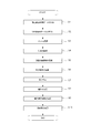
- FIG. 1 shows a rough flow of a procedure of solar radiation amount evaluation according to the present invention
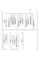
- FIG. 2 shows a block diagram of a computer that executes this procedure.
- the computer includes an input unit 20 including an acquisition unit 9, a storage unit 22 for storing three-dimensional map data 21, an operation unit 23, and an output unit 24 for outputting an operation result to a monitor or the like not shown. Is configured.
- the computer executes the step (step S1) of acquiring the geostationary satellite image data 1 from the Japan Meteorological Association etc. via the Internet or an appropriate storage medium by the acquisition means 9, for example. It is started.
- shooting date and time information and coordinate information including latitude and longitude of a shooting area are also simultaneously obtained as annotation data.
- the stationary satellite image data 1 is a set of pixels having a density according to the ground resolution, and each pixel has a pixel value 5 composed of luminance data or the like.
- the pixel value 5 is reflection data from the object to be photographed, and therefore, for example, land and sea with greatly different reflectances are largely different. Therefore, a portion where the pixel value 5 is linearly greatly different is determined as a coastline or the like. It is possible.
- the arithmetic unit 23 described above is, as shown in FIG. 2, a map model combining unit 10, an evaluation target area setting unit 11, and a shadow judging unit 12 , Inclination correction calculation means 14, and solar radiation amount evaluation means 13.
- the map model combining means 10 combines the geostationary satellite image data 1 with the three-dimensional map data 21 described above, performs geometric correction on the geostationary satellite image data 1, and interleaves the above-mentioned coordinate information into three-dimensional map data. Align to 21 and bond. It should be noted that since this alignment is a little less accurate because the coordinate accuracy of the geostationary satellite image data 1 is low, the map model combining means 10 is provided with a connecting point setting unit (not shown) for extracting the coastline etc. described above as a connecting point. And error correction is added by matching of bonding points upon alignment.
- the evaluation target area setting means 11 sets an area for evaluating the amount of solar radiation, and includes mesh setting means 25, representative value setting means 26, and area setting means 27, as shown in FIG. Configured
- the mesh setting means 25 sets the mesh 3 on the geostationary satellite image data 1, more precisely on synthetic data obtained by combining the geostationary satellite image data 1 with the three-dimensional map data 21 as described above.
- the ground resolution of the satellite image data 1, that is, one pixel on the geostationary satellite image data 1, is adjusted to the corresponding ground area.
- the representative value setting means 26 sets single representative coordinate information in each of the cells 8, 8... Of the formed mesh 3. In this embodiment, the center of each cell 8 is set. A point is taken as a determination representative point 28 and its coordinate information is applied.
- the area setting means 27 is an area to be evaluated in the synthesized data of the area designated by the input from the mouse (not shown) included in the input unit 20 described above, in other words, the single or plural cells 8 It is set to.
- the evaluation target area is not specified from the input unit 20
- the entire area on the geostationary satellite image data 1 may be set as the evaluation target area to proceed with the process.
- the shade judging means 12 judges the shade area 4 by using the three-dimensional map model 2 of the three-dimensional map data 21 included in the composite data described above, and the shade calculating means 29 and the cell judging means And 30.
- the sun position for calculating the shadow area 4 can be specified by the shooting date and time information described above, and the shadow calculating means 29 refers to the date and time / sun coordinate table 31 provided in the storage unit 22.
- the sun position is acquired from the shooting date and time information, and the solar radiation is simulated on the three-dimensional map model 2 to calculate the shadow area 4 in the evaluation target area.
- the cell determination means 30 determines whether or not the cell belongs to the shadow area 4 in units of cells 8 in the evaluation target area. In this embodiment, the center point of the cell 8 described above is used as the determination representative point 28. The determination is made based on whether the determination representative point 28 belongs to the shadow area 4 or not.
- the inclination correction operation means 14 is an inclination extraction means 32 for setting inclination information of each cell 8 in the evaluation target area based on the three-dimensional map model 2 described above, that is, a representative inclination angle of each cell 8 and a representative inclination direction.
- the inclination correction coefficient for calculating from the assumed amount of solar radiation that each cell 8 would receive when assuming each cell 8 as the horizontal surface, for each cell 8 when taking this representative inclination angle and representative inclination orientation And slope correction coefficient setting means 33 to be set.
- the inclination extraction means 32 determines the inclination information of each cell 8 based on the elevation information of the peripheral cells 8 consisting of 8 cells located in the vertical, horizontal, and diagonal peripheral 8 directions of the cell 8. .
- the elevation difference between the peripheral cell 8 and the central cell 8 located at the center is determined for all eight directions, and the inclination angle of the central cell 8 when the total for all eight directions of the differences is smallest.
- the inclination orientation is determined to be the representative inclination angle and the representative inclination orientation.
- the inclination correction coefficient setting means 33 sets, for each cell 8, an inclination correction coefficient to be converted to a representative inclination angle from the amount of solar radiation when assuming each cell 8 as a horizontal surface and the amount of solar radiation when taking a representative inclination direction.
- the tilt correction coefficient is a function of tilt information of the cell 8 with respect to the horizontal plane, and may be calculated by sequentially using, for example, the sun position specified by the shooting date and time information.
- the solar radiation amount evaluation means 13 is configured to calculate the solar radiation amount itself in the evaluation target region, and in this embodiment, the solar radiation amount of the evaluation target region is each in the evaluation target region. It is calculated by averaging the amount of solar radiation of the cell 8. Furthermore, by averaging the amount of solar radiation in a plurality of geostationary satellite image data 1, 1, ... with different imaging times, the amount of solar radiation in hourly units such as per day, per day, per month can be calculated appropriately .
- the calculation of the amount of solar radiation for each cell 8 assumes that the calculation target region is a horizontal plane, and the above-mentioned shadows with respect to the estimated amount of solar radiation calculated by the existing method of calculating the amount of solar radiation not taking into account the occurrence of shadows due to topography. And it is made to reflect the attenuation by the slope. More specifically, the calculation of the estimated amount of solar radiation is performed from the pixel value 5 of the stationary satellite image data 1 corresponding to each cell 8 to each cell 8 with reference to the solar radiation transmission coefficient table 7 of the pixel value and cloud of the storage unit 22. The solar radiation transmission coefficient (solar radiation amount evaluation element 6) of the cloud is acquired, and a solar zenith angle etc. is derived using the above-mentioned solar position, or it is necessary for a known solar radiation amount formula Various calculation parameters appropriately obtained and calculated.
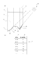
- the above-mentioned pixel value / cloud solar radiation transmission coefficient table 7 is a table in which the pixel value 5 for which a certain relationship is recognized is associated with the cloud solar radiation transmission coefficient 6, as shown in FIG. 4 (b). It is possible to form, for example, by accumulating pixel values 5 in the past and the measured amount of solar radiation and deriving correspondence by a statistical method.
- the pixel value 5 corresponding to the cell 8 described above is generally the pixel value 5 of the cell 8 in the composite data described above, in the case of a sun position where the incident angle of sunlight to the ground surface is extremely obtuse In some cases, it is conceivable that sunlight incident on the ground surface of the cell 8 passes through a cloud on another cell 8, so that a cloud based on the pixel value 5 of the other cell 8 corresponding to the incident angle It is also possible to employ a solar radiation transmission coefficient of 6.
- the amount of solar radiation is set to 0 or attenuated by a predetermined rate, and The solar radiation amount for each cell 8 (evaluation element after topographical condition correction) is calculated by repeating the correction calculation using the above-described inclination correction coefficient.
- the solar radiation amount obtained by averaging the solar radiation amounts of all the cells 8 belonging to the evaluation target area or further averaging the calculation results from the plurality of stationary satellite image data 1 is output from the output unit 24 It is displayed on the monitor outside the figure.
- the display can be performed, for example, by overlapping a color selected according to the amount of solar radiation on the evaluation target area and expressing it on map data.
- step S2 the step of combining with the two-dimensional map data 21 is executed (step S2), and then the combined data obtained in this way is adjusted in advance to the ground resolution of the stationary satellite image data 1, for example,
- step S3 The step of setting the mesh 3 set according to the plane coordinates is executed (step S3).
- the representative value setting unit 26 refers to the three-dimensional coordinate information of the determination representative point 28 of each cell 8 of the mesh 3 using the three-dimensional coordinate information included in the three-dimensional map data 21 and uses this coordinate information.
- the step (step S4) of setting each cell 8 as an attribute or the like related to coordinates is executed, and the area setting means 27 sets maps and coordinate information included in the three-dimensional map data 21 described above for the evaluation target area of the solar radiation amount.
- the step of setting based on the section of the mesh 3 using the step (step S5) is executed.
- the sun position is identified by the shadow computing means 29 with reference to the date / time / sun coordinate table 31 according to the shooting date / time information acquired by the acquiring means 9, and this sun position is constituted by the sun position and the above three-dimensional map data 21.
- step S6 After performing the step (step S6) of calculating the shadow area 4 generated in the evaluation target area from the possible three-dimensional map model 2, each cell 8 in the evaluation target area is a shadow area by the cell determination unit 30. A determination is made as to whether or not the cell belongs to 4, and the step of setting the determination result as an attribute relating to the shadow of each cell 8 (step S7) is executed. Therefore, for example, as shown in FIG.
- one stationary satellite image data surface, three-dimensional map data 21 surface, and the three-dimensional map model 2 based on the three-dimensional map data 21 are mutually aligned.
- mesh 3 is set corresponding to the ground resolution of the pixel as shown by the dotted line, and light from the sun 34, which takes a position specified by the photographing date and time information, is incident on the three-dimensional map model 2
- a shaded area 4 as indicated by hatching occurs, the cells 8 belonging to the shaded area 4 of the representative representative points 28 of the cells 8 indicated by white circles on the outline of the three-dimensional map model 2 have three-dimensional map data 21 It is determined that the shadow is a shadow as indicated by a thick line above, and the remaining cells 8 are determined not to be a shadow.
- step S8 the step of extracting the representative inclination angle and the representative inclination direction of each cell 8 from the elevation value difference with the adjacent cell 8 obtained by referring to the three-dimensional map data 21 by the inclination extraction means 32 (step S8) Then, based on the inclination information and the incident angle of sunlight to each cell 8 specified from the sun position, etc., the inclination correction coefficient of the pixel value 5 of the geostationary satellite image data 1 and the amount of solar radiation is calculated The step (step S9) of setting the inclination correction coefficient as an attribute related to the inclination of each cell 8 is performed.
- step S10 the step of calculating the amount of solar radiation of the evaluation area based on the pixel value 5 of each cell 8, the coordinate information, the attribute regarding the shadow, the inclination correction coefficient, and the sun position by the solar radiation amount evaluation means 13.
- the cloud transmission coefficient 6 is acquired from the pixel value 5 of each cell 8 with reference to the solar value transmission coefficient table 7 of the pixel value and the cloud, and the cloud transmission coefficient of this cloud From the position of the sun 6, the coordinate information of each cell 8, etc., the estimated solar radiation amount when each cell 8 is not shaded by the topography and is assumed to be a horizontal surface is calculated (step S10-1).
- step S10-2 the inclination correction coefficient is further referred to as it is.
- the amount of solar radiation is calculated from the estimated amount of solar radiation (step S10-4).
- a shadow correction coefficient is set to convert the above-mentioned amount of solar radiation into a amount of solar radiation considering the shadow (step S10-3)
- the solar radiation amount is calculated from the estimated solar radiation amount using the shadow correction coefficient together with the above-described inclination correction coefficient (step S10-4).
- the above calculation of the amount of solar radiation is repeated for all the cells 8, 8 ⁇ in the evaluation area (step S10-5), and if the amount of solar radiation is obtained for all the cells 8 ⁇ 8 ⁇ ⁇ in the evaluation object area
- the solar radiation amount (S10-6) of the evaluation area is calculated by averaging these.
- the calculation of the solar radiation amount of the above evaluation target area is performed for the plurality of geostationary satellite image data 1 Then, the process is repeated (step S10-7), and thereafter, a plurality of solar radiation amounts of the evaluation target area calculated respectively are averaged to obtain a long solar radiation amount per unit time (step S10-8).
- determination of the shadow, reflection of the shadow determination result on the cell 8 is processed prior to calculation of the inclination calculation and reflection of the inclination calculation result on the cell 8, but calculation of the inclination, etc. It is also possible to process prior to the judgment of the shadow and the like.
- Reference Signs List 1 geostationary satellite image data 2 three-dimensional map model 3 mesh 4 shadow area 5 pixel value 6 solar radiation evaluation element 7 table 8 cell 9 acquisition means 10 map model connection means 11 evaluation target area setting means 12 shadow judgment means 13 solar radiation amount Evaluation means 14 Tilt correction operation means
Landscapes
- Environmental & Geological Engineering (AREA)
- Engineering & Computer Science (AREA)
- Life Sciences & Earth Sciences (AREA)
- Atmospheric Sciences (AREA)
- Biodiversity & Conservation Biology (AREA)
- Ecology (AREA)
- Environmental Sciences (AREA)
- Image Processing (AREA)
- Processing Or Creating Images (AREA)
Abstract
【課題】地形条件を考慮することにより精度を高めることができる日射量の評価方法および評価装置の提供を目的とする。 【解決手段】静止衛星画像データ1を3次元地図モデル2と結合させて静止衛星画像データ1の地上解像度に従って平面座標に基づくメッシュ3を設定し、 3次元地図モデル2と撮像日時データにより特定される太陽位置とに基づいて日影領域4を演算し、前記メッシュ3の各セル8が日影領域4に属するか否かを判定するとともに、 静止衛星画像データ1における各画素の画素値5と各画素に対応する領域の日射量評価要素6とを対応づけたテーブル7を参照して評価対象領域内の各セル8の日射量評価要素6を取得し、且つ、当該セル8が日影領域4に属すると判定されている場合には日射量評価要素6に所定の補正計算を加えて算出される地形条件補正後評価要素を取得する。
Description
本発明は日射量の評価方法および評価装置に関するものである。
所定領域についての日射量の評価に静止衛星画像を用いるものとしては、従来、特許文献1に記載のものが知られている。この従来例は静止衛星画像の画素値から各画素に対応する領域のアルベード値や輝度温度を取得するもので、予め取得しておいた過去における同一時間帯の晴天時のアルベード値等と比較することにより晴天か雲天かを判別し、晴天か雲天かに応じてそれぞれ所定の計算式により日射量を算出する。計算式には太陽天頂角や太陽定数、太陽-地球間の距離、オゾンの吸収に関する透過率等の各種透過率、雲の日射吸収係数などが用いられるほか、上記アルベード値も用いられる。なお、上記アルベード値は画素の反射率を太陽天頂角の余弦で除算して得られる。
また、特許文献2には、反射量と日射量が統計的な関係に基づいた回帰係数によって直接的に結びつけられることを利用し、反射量、すなわち静止気象衛星画像の画素値に基づいて直接的に日射量を推定する手法について記載されている。
以上の従来例のように、静止衛星画像を日射量の評価に用いる場合、画素値のみ、あるいはこれに加えて太陽や大気の性状といった天体、気象条件ばかりが考慮されるに過ぎず、地形条件を考慮していなかったために精度に劣り、例えば農業の作柄やヒートアイランド現象の解析などの用途においては評価が有効に機能することができなかった。
本発明はかかる欠点を解消すべくなされたものであって、地形条件を考慮することにより精度を高めることができる日射量の評価方法および評価装置の提供を目的とする。
本発明によれば上記目的は、
静止衛星画像データ1を撮像日時データとともに取得した後、
前記静止衛星画像データ1を3次元地図モデル2と結合させ、
次いで、結合データに静止衛星画像データ1の地上解像度に従って平面座標に基づくメッシュ3を設定し、該メッシュ3に従って結合データ中の所定領域を評価対象領域として設定し、
この後、前記3次元地図モデル2と前記撮像日時データにより特定される太陽位置とに基づいて前記評価対象領域内に生じる日影領域4を演算し、所定の判定基準に従って前記メッシュ3の各セル8が日影領域4に属するか否かを判定するとともに、
静止衛星画像データ1における各画素の画素値5と各画素に対応する領域の日射量評価要素6とを対応づけたテーブル7を参照して前記評価対象領域内の各セル8の日射量評価要素6を取得し、且つ、当該セル8が日影領域4に属すると判定されている場合には前記日射量評価要素6に所定の補正計算を加えて算出される地形条件補正後評価要素を前記日射量評価要素6に代えて取得して評価対象領域の日射量を評価する日射量の評価方法を提供することにより達成される。
本発明によれば、地形による日影の発生を考慮して日射量を評価することができるため、地形による日影の影響が及ぶような領域の評価精度を極めて高めることができる。日影の発生は、精密な位置情報を付与するために従来より静止衛星画像データ1に結合されていた2次元地図データに代えて3次元地図データ21を用い、3次元地図モデル2と太陽位置とにより日影領域4を演算することで把握することができる。
したがって本発明によれば、農業の作柄、作物適地選定、精密農業のパラメータや、ヒートアイランド現象の解析といった際に要求される精度に応えることができる日射量評価を行うことができる。
また、日影領域4の判定は、静止衛星画像データ1と3次元地図モデル2とを結合して形成される結合データに静止衛星画像データ1の地上解像度に従って平面座標に基づくメッシュ3を設定し、このメッシュ3のセル8単位で行うことにより、比較的高い分解能が見込まれる3次元地図データ21と、比較的低い分解能しか期待しにくい静止衛星画像データ1との間で分解能を徒に低下させることなく行うことができる。この場合、セル8の中心を判定代表点28とし、太陽位置との関係で日影領域4が演算される3次元地図モデル2上において、上記判定代表点28が日影領域4に属するか否かをセル8単位の日影判定基準にすることができる。
以上のようにして日影領域4に属すると判定されたときの日射量の評価への反映は、日影の発生を考慮していなかった従来技術において導き出される日射量評価要素6に所定の補正計算を加えれば足りる。この補正計算は、日影による直達日射量の喪失を考慮したり、経験則に基づいた統計に従って設定したりするなどして適宜行うことが可能である。
また、日射量評価に対する地形条件の考慮は、以上の地形による日影発生のほか、傾斜地形に対するものとしても有用であり、この場合、
静止衛星画像データ1を撮像日時データとともに取得した後、
前記静止衛星画像データ1を3次元地図モデル2と結合させ、
次いで、結合データに静止衛星画像データ1の地上解像度に従って平面座標に基づくメッシュ3を設定し、該メッシュ3に従って結合データ中の所定領域を評価対象領域として設定し、
この後、前記3次元地図モデル2に基づいて所定の判定基準に従って評価対象領域内のメッシュ3の各セル8の代表傾斜角および代表傾斜方位を求め、前記撮像日時データにより特定される太陽位置から各セル8が日射方向に垂直な平面(水平面)と仮定された場合に受ける日射量評価から前記代表傾斜角および代表傾斜方位をとるときに受ける日射量評価へと変換する傾斜補正係数を各セル8毎に演算し、
且つ、静止衛星画像データ1における各画素の画素値5と各画素に対応する領域を水平面に仮定したときの領域毎の日射量評価要素6とを対応づけたテーブル7を参照して前記評価対象領域内の各セル8の日射量評価要素6を取得した後、該日射量評価要素6を前記補正係数により補正計算して算出されたセル8毎の地形条件補正後評価要素を取得して評価対象領域の日射量を評価するように日射量の評価方法を構成することができる。
この発明において、日射量の評価は、日射を受ける評価対象領域の地表面の傾斜を考慮してなされ、これにより傾斜地の日射量の評価精度を極めて高めることができる。傾斜情報は3次元地図データ21から取得することが可能であり、例えば、上述同様、セル8の中心を判定代表点28とし、各セル8の代表傾斜角および代表傾斜方位を周辺セル8の判定代表点28の標高データにおける差分に基づいて演算して判断することが可能である。
したがってこの発明においても、上述同様、農業の作柄、作物適地選定、精密農業のパラメータや、ヒートアイランド現象の解析といった際に要求される精度に応えることができる日射量評価を行うことができる。
傾斜情報の日射量評価への反映は、傾斜情報から日射量評価の補正係数を演算しておけばよく、地表面の傾斜を考慮していなかった従来技術において導き出される評価値に補正係数により補正計算を加えれば足りる。補正係数は、例えばランベルトの余弦則を考慮するなどして適宜決定することが可能である。
また、以上のように地表面の傾斜情報を得ておくことにより、太陽位置と地表面の傾斜情報に基づいて太陽光の地表面からの反射日射量を演算し、日射量の評価に加えることも可能である。
以上の2発明において、静止衛星画像データ1の画素値5と一対一対応して導き出されるようにされる日射量評価要素6としては、上述した従来例のように、日射量をそのまま適用したり、あるいは日射量を把握する際の主要要素となり得る雲の日射透過係数等を適用したりすることが可能であり、また、日射量評価のための評価量としては、同様に日射量をそのまま適用したり、あるいは適宜の指数を採用することが可能である。この場合において、日射量の評価指数として機能させることが可能な上述の雲の日射透過係数を採用した場合、特定されている太陽位置から雲の日射透過係数を用いて日射量を演算して評価することもできる。
また、以上においては地形による日影情報や、地表面の傾斜情報を各々用いることにより地形条件を考慮した日射量評価を行う場合を示したが、これら双方の情報を合わせて考慮することによって評価精度をさらに向上させることができる。加えて、以上において評価要因とする静止衛星画像データ1について撮像時間を異ならせたものを複数用い、複数の静止衛星画像データ1から複数の日射量評価要素6、補正後評価要素を取得し、これらを平均して所定時間当たりの日射量評価要素6等を算出したり、日射量評価要素6等の時間的な変化を把握することも可能である。
以上の説明から明らかなように、本発明によれば、地形条件を考慮することにより精度を高めた日射量の評価方法および評価装置を提供することができ、農業の作柄、作物適地選定、精密農業のパラメータや、ヒートアイランド現象の解析を日射量評価に基づいて行うことができる。
図1に本発明に係る日射量評価の処理手順の大まかな流れを、図2にこの処理手順を実行するコンピュータのブロック図を示す。このコンピュータは、取得手段9を備えた入力部20と、3次元地図データ21を格納する記憶部22と、演算部23と、図外のモニタ等に演算結果を出力する出力部24とを備えて構成される。日射量評価の処理は、先ず最初にコンピュータが上記取得手段9により例えばインターネットあるいは適宜の記憶媒体を介して日本気象協会等から静止衛星画像データ1を取得するステップ(ステップS1)を実行することにより開始される。この静止衛星画像データ1の取得に際しては、アノテーションデータとして同時に撮影日時情報や撮影領域の緯度や経度からなる座標情報も取得される。
上記静止衛星画像データ1は地上解像度に従った密度の画素の集合であり、各画素は輝度データ等からなる画素値5を備える。この画素値5は撮影対象からの反射データであり、したがって例えば反射率の大きく異なる陸と海では大きく異なり、このため線状に画素値5が大きく異なって配置される部位を海岸線等として判断することが可能である。
以上の静止衛星画像データ1に基づいて日射量を評価するために、上述した演算部23は、図2に示すように、地図モデル結合手段10、評価対象領域設定手段11、日影判定手段12、傾斜補正演算手段14、日射量評価手段13を有して構成される。
地図モデル結合手段10は、静止衛星画像データ1を上述した3次元地図データ21と結合させるものであり、静止衛星画像データ1に幾何補正を施し、上述した座標情報を媒介にして3次元地図データ21に位置合わせして結合する。なお、この位置合わせは静止衛星画像データ1の座標精度が低いことからやや精度に劣るため、地図モデル結合手段10には上述した海岸線等を結合ポイントとして抽出する図示しない結合ポイント設定部が設けられ、位置合わせに際して結合ポイントのマッチングによる誤差修正が加えられる。
評価対象領域設定手段11は、日射量を評価する領域を設定するものであり、図2に示すように、メッシュ設定手段25と、代表値設定手段26と、領域設定手段27とを有して構成される。メッシュ設定手段25は静止衛星画像データ1、より正確には上述したように静止衛星画像データ1を3次元地図データ21と結合した合成データ上にメッシュ3を設定するもので、このメッシュ3は静止衛星画像データ1の地上解像度、すなわち静止衛星画像データ1上の1画素が対応している地上領域に合わせられる。また、代表値設定手段26は、形成されたメッシュ3の各セル8、8、・・に単一の代表的な座標情報を設定するものであり、この実施の形態においては各セル8の中心点が判定代表点28とされてその座標情報が適用される。領域設定手段27は、上述した入力部20に含まれる図示しないマウス等からの入力により指定された領域、言い換えれば指定した領域に対応する単数あるいは複数のセル8のみを合成データ内における評価対象領域に設定するものである。なお、入力部20からの評価対象領域の指定がない場合には、静止衛星画像データ1上の全領域を評価対象領域に設定して処理を進めるようにすることも可能である。
日影判定手段12は、上述した合成データに含まれる3次元地図データ21の3次元地図モデル2を利用して日影領域4を判定するものであり、日影演算手段29と、セル判定手段30とを備える。日影領域4を演算するための太陽位置は上述した撮影日時情報により特定することが可能であり、日影演算手段29は、記憶部22に設けられた日時・太陽座標テーブル31を参照して撮影日時情報から太陽位置を取得し、3次元地図モデル2上に日射をシミュレートして評価対象領域内の日影領域4を演算する。セル判定手段30は、日影領域4に属するか否かを評価対象領域内においてセル8単位で判定するものであり、この実施の形態においては上述したセル8の中心点を判定代表点28とし、この判定代表点28が日影領域4に属しているか否かにより判定する。
傾斜補正演算手段14は、上述した3次元地図モデル2に基づいて評価対象領域内の各セル8の傾斜情報、すなわち各セル8の代表傾斜角、代表傾斜方位を設定する傾斜抽出手段32と、この代表傾斜角、代表傾斜方位をとるときに各セル8が受ける日射量を各セル8が水平面と仮定したときに受けるであろう仮定日射量から算出するための傾斜補正係数をセル8毎に設定する傾斜補正係数設定手段33とを有する。傾斜抽出手段32は、この実施の形態において、各セル8の傾斜情報を当該セル8の縦・横・斜めの周辺8方向に位置する8セルからなる周辺セル8の標高情報に基づいて決定する。より具体的には、例えば、周辺セル8と中心に位置する中心セル8との標高差分を8方向全てについて求め、差分の8方向全てについての合計が最も小さくなるときの中心セル8の傾斜角、傾斜方位を代表傾斜角、代表傾斜方位に決定する。また、傾斜補正係数設定手段33は、各セル8を水平面と仮定したときの日射量から代表傾斜角、代表傾斜方位をとるときの日射量に変換する傾斜補正係数をセル8毎に設定する。この傾斜補正係数は、セル8の水平面に対する傾斜情報の関数であり、例えば撮影日時情報により特定される太陽位置を逐次利用して算出するように構成してもよい。
日射量評価手段13は、この実施の形態においては評価対象領域内の日射量自体を算出するものとして構成され、また、この実施の形態において評価対象領域の日射量は、評価対象領域内の各セル8の日射量を平均して算出される。さらにまた、撮影時間の異なる複数の静止衛星画像データ1、1、・・における日射量を平均することにより、1時間当たり、1日当たり、1ヶ月当たりなどの適宜時間単位の日射量が算出される。
セル8毎の日射量の算出は、算出対象領域を水平面に仮定し、且つ、地形による日影の発生を考慮しない既存の日射量算出手法により算出される推定日射量に対し、上述した日影や傾斜による減衰を反映してなされる。上記推定日射量の算出は、具体的には、記憶部22の画素値・雲の日射透過係数テーブル7を参照して各セル8に対応する静止衛星画像データ1の画素値5から各セル8の雲の日射透過係数(日射量評価要素6)を取得し、また、上述した太陽位置を利用して太陽天頂角等を導き出し、あるいは記憶部22から読み出す等、公知の日射量計算式に必要な各種計算パラメータを適宜入手して計算することによってなされる。
なお、上記画素値・雲の日射透過係数テーブル7は、一定の関連性が認められる画素値5と雲の日射透過係数6とを対応づけたものであり、図4(b)に示すように構成することが可能で、例えば過去における画素値5と実測日射量を蓄積して統計的手法により対応付けを導き出すことなどにより形成することが可能である。また、上述したセル8に対応する画素値5とは、一般には上述した合成データにおいて当該セル8の画素値5となるが、地表面に対する太陽光の入射角が極めて鈍角になる太陽位置の場合には、当該セル8の地表面に入射する太陽光が他のセル8上の雲を通過している場合も考えられることから、入射角に対応する他のセル8の画素値5に基づく雲の日射透過係数6を採用することも可能である。
また、このようにして推定日射量を得た後は、セル判定手段30の当該セル8に対する判定が日影判定であった場合には、日射量を0にし、あるいは所定割合減衰させ、さらに、上述した傾斜補正係数による補正計算を重ねてセル8毎の日射量(地形条件補正後評価要素)が算出される。上述したように評価対象領域に属する全セル8の日射量を平均し、あるいはさらに、複数の静止衛星画像データ1からの算出結果を平均して得た日射量は、出力部24から出力されて図外のモニタに表示される。表示は、例えば、日射量に応じて選定される色を評価対象領域に重ねて地図データ上に表現するなどにより行うことができる。
以上の演算部23によるコンピュータの動作手順を図1に従って説明する。演算部23は、上述したように静止衛星画像データ1等が取得手段9により取得されると、記憶部22から3次元地図データ21を読み出し、地図モデル結合手段10により静止衛星画像データ1と3次元地図データ21とを結合させるステップ(ステップS2)を実行し、次に、このようにして得られた結合データ上に、メッシュ設定手段25により、例えば予め静止衛星画像データ1の地上解像度に合わせて設定されたメッシュ3を平面座標に従って設定するステップを実行する(ステップS3)。
次いで、代表値設定手段26により、上記3次元地図データ21に含まれる3次元座標情報を利用してメッシュ3の各セル8の判定代表点28の3次元座標情報を参照し、この座標情報を各セル8に座標に関する属性等として設定するステップ(ステップS4)を実行するとともに、領域設定手段27により、日射量の評価対象領域について、上述した3次元地図データ21に含まれる地図や座標情報を利用して、メッシュ3の区画に基づいて設定するステップ(ステップS5)を実行する。
この後、日影演算手段29により、取得手段9により取得されている撮影日時情報により日時・太陽座標テーブル31を参照して太陽位置を特定し、この太陽位置と上記3次元地図データ21により構成可能な3次元地図モデル2とから評価対象領域に発生する日影領域4を演算するステップ(ステップS6)を実行した後、セル判定手段30により、評価対象領域内の各セル8が日影領域4に属するか否かの判定がなされ、判定結果を各セル8の日影に関する属性として設定するステップ(ステップS7)を実行する。したがって例えば図4(a)に示すように、静止衛星画像データ1面と、3次元地図データ21面と、この3次元地図データ21に基づく3次元地図モデル2とが相互に位置合わせされ、図において点線で示すように画素の地上解像度に対応してメッシュ3が設定され、上記3次元地図モデル2に対して撮影日時情報により特定される位置をとる太陽34からの光が入射して図においてハッチングで示すような日影領域4が発生する場合、3次元地図モデル2の輪郭線上に白丸で示す各セル8の判定代表点28が日影領域4に属するセル8は3次元地図データ21面上に太線で示すように日影と判定され、残余のセル8は日影でないと判定される。
一方、傾斜抽出手段32により、3次元地図データ21を参照して得られる隣接するセル8との標高値差分から各セル8の代表傾斜角、代表傾斜方位を抽出するステップ(ステップS8)が実行された後、この傾斜情報と太陽位置とから特定される各セル8への太陽光の入射角等に基づいて、静止衛星画像データ1の画素値5と日射量との傾斜補正係数を演算し、傾斜補正係数を各セル8の傾斜に関する属性として設定するステップ(ステップS9)が実行される。
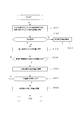
そして最後に、日射量評価手段13により、各セル8の画素値5、座標情報、日影に関する属性、傾斜補正係数、および太陽位置に基づいて、評価対象領域の日射量を算出するステップ(ステップS10)が実行される。具体的には、図3に示すように、先ず、画素値・雲の日射透過係数テーブル7を参照して各セル8の画素値5から雲の透過係数6を取得し、この雲の透過係数6と太陽位置、各セル8の座標情報等から各セル8を地形によって日影になることがなく、かつ水平面と仮定したときの推定日射量が算出される(ステップS10-1)。次に、各セル8の日影に関する属性等を参照し(ステップS10-2)、日影ではないと判定されているセル8については、さらにそのまま傾斜補正係数を参照して該傾斜補正係数を用いて推定日射量から日射量を算出する(ステップS10-4)。
一方、上述とは逆に日影と判定されているセル8については、上述した日射量から日影を考慮した日射量に変換する日影補正係数を設定し(ステップS10-3)、この後、上述した傾斜補正係数と合わせて日影補正係数を用いて推定日射量から日射量を算出する(ステップS10-4)。以上の日射量の算出は評価対象領域内の全てのセル8、8・・について繰り返され(ステップS10-5)、評価対象領域内の全てのセル8、8・・について日射量が得られたらこれを平均して評価対象領域の日射量(S10-6)を演算する。また、撮像時間が異なる静止衛星画像データ1の複数を用いて単位時間の比較的長い日射量を求めるこの発明において、以上の評価対象領域の日射量の算出は複数の静止衛星画像データ1に対して繰り返し行われ(ステップS10-7)、この後、各々算出される評価対象領域の日射量の複数を平均して単位時間の長い日射量が求められる(ステップS10-8)。
なお、以上においては日影の判定や、セル8に対する日影判定結果の反映を傾斜の演算やセル8に対する傾斜演算結果の反映に先立って処理する場合を示したが、傾斜の演算等を日影の判定等に先だって処理することも可能である。
1 静止衛星画像データ
2 3次元地図モデル
3 メッシュ
4 日影領域
5 画素値
6 日射量評価要素
7 テーブル
8 セル
9 取得手段
10 地図モデル結合手段
11 評価対象領域設定手段
12 日影判定手段
13 日射量評価手段
14 傾斜補正演算手段
2 3次元地図モデル
3 メッシュ
4 日影領域
5 画素値
6 日射量評価要素
7 テーブル
8 セル
9 取得手段
10 地図モデル結合手段
11 評価対象領域設定手段
12 日影判定手段
13 日射量評価手段
14 傾斜補正演算手段
Claims (8)
- 静止衛星画像データを撮像日時データとともに取得した後、
前記静止衛星画像データを3次元地図モデルと結合させ、
次いで、結合データに静止衛星画像データの地上解像度に従って平面座標に基づくメッシュを設定し、該メッシュに従って結合データ中の所定領域を評価対象領域として設定し、
この後、前記3次元地図モデルと前記撮像日時データにより特定される太陽位置とに基づいて前記評価対象領域内に生じる日影領域を演算し、所定の判定基準に従って前記メッシュの各セルが日影領域に属するか否かを判定するとともに、
静止衛星画像データにおける各画素の画素値と各画素に対応する領域の日射量評価要素とを対応づけたテーブルを参照して前記評価対象領域内の各セルの日射量評価要素を取得し、且つ、当該セルが日影領域に属すると判定されている場合には前記日射量評価要素に所定の補正計算を加えて算出される地形条件補正後評価要素を前記日射量評価要素に代えて取得して評価対象領域の日射量を評価する日射量の評価方法。 - 静止衛星画像データを撮像日時データとともに取得した後、
前記静止衛星画像データを3次元地図モデルと結合させ、
次いで、結合データに静止衛星画像データの地上解像度に従って平面座標に基づくメッシュを設定し、該メッシュに従って結合データ中の所定領域を評価対象領域として設定し、
この後、前記3次元地図モデルに基づいて所定の判定基準に従って評価対象領域内のメッシュの各セルの代表傾斜角および代表傾斜方位を求め、前記撮像日時データにより特定される太陽位置から各セルが水平面と仮定された場合に受ける日射量評価から前記代表傾斜角および代表傾斜方位をとるときに受ける日射量評価へと変換する傾斜補正係数を各セル毎に演算し、
且つ、静止衛星画像データにおける各画素の画素値と各画素に対応する領域を水平面に仮定したときの領域毎の日射量評価要素とを対応づけたテーブルを参照して前記評価対象領域内の各セルの日射量評価要素を取得した後、該日射量評価要素を前記補正係数により補正計算して算出されたセル毎の地形条件補正後評価要素を取得して評価対象領域の日射量を評価する日射量の評価方法。 - 前記各セルには、セルの中心点を基準にした3次元座標データが各々設定され、
且つ、前記撮像日時データにより特定される太陽位置で各セルが日影領域に属するか否かを前記中心点の3次元座標が3次元地図モデルにおいて日影領域に属するか否かで判定する請求項1記載の日射量の評価方法。 - 前記各セルには、セルの中心点を基準にした3次元座標データが各々設定され、
且つ、各セルの代表傾斜角および代表傾斜方位を周辺セルの中心点の標高データと中心セルの中心点の標高データとの差分に基づいて演算する請求項2記載の日射量の評価方法。 - 前記テーブルには、日射量評価要素として雲の日射透過係数が設定され、
前記撮像日時データにより特定される太陽位置と前記日射透過係数に基づいて日射量が演算される請求項1記載の日射量の評価方法。 - 静止衛星画像データを撮像日時データとともに取得する取得手段と、
前記静止衛星画像データを3次元地図モデルと結合させる地図モデル結合手段と、
結合データに静止衛星画像データの地上解像度に従って平面座標に基づくメッシュを設定し、該メッシュに従って結合データ中の所定領域を評価対象領域として設定する評価対象領域設定手段と、
前記3次元地図モデルと前記撮像日時データにより特定される太陽位置とに基づいて前記評価対象領域内に生じる日影領域を演算し、所定の判定基準に従って前記メッシュの各セルが日影領域に属するか否かを判定する日影判定手段と、
前記静止衛星画像データにおける各画素の画素値と各画素に対応する領域の日射量評価要素とを対応づけたテーブルを参照して前記評価対象領域内の各セルの日射量評価要素を取得し、且つ、当該セルが日影領域に属すると判定されている場合には前記日射量評価要素に所定の補正計算を加えて算出される地形条件補正後評価要素を前記日射量評価要素に代えて取得して評価対象領域の日射量を評価する日射量評価手段とを有する日射量の評価装置。 - 静止衛星画像データを撮像日時データとともに取得する取得手段と、
前記静止衛星画像データを3次元地図モデルと結合させる地図モデル結合手段と、
結合データに静止衛星画像データの地上解像度に従って平面座標に基づくメッシュを設定し、該メッシュに従って結合データ中の所定領域を評価対象領域として設定する評価対象領域設定手段と、
前記3次元地図モデルに基づいて所定の判定基準に従って評価対象領域内のメッシュの各セルの代表傾斜角および代表傾斜方位を求め、前記撮像日時データにより特定される太陽位置から各セルが水平面と仮定された場合に受ける日射量評価から前記代表傾斜角および代表傾斜方位をとるときに受ける日射量評価へと変換する補正係数を各セル毎に演算する傾斜補正演算手段と、
前記静止衛星画像データにおける各画素の画素値と各画素に対応する領域を水平面に仮定したときの領域毎の日射量評価要素とを対応づけたテーブルを参照して前記評価対象領域内の各セルの日射量評価要素を取得した後、該日射量評価要素を前記補正係数により補正計算して算出されたセル毎の地形条件補正後評価要素を取得して評価対象領域の日射量を評価する日射量評価手段とを有する日射量の評価装置。 - 静止衛星画像データを撮像日時データとともに取得した後、
前記静止衛星画像データを3次元地図モデルと結合させ、
次いで、結合データに静止衛星画像データの地上解像度に従って平面座標に基づくメッシュを設定し、該メッシュに従って結合データ中の所定領域を評価対象領域として設定し、
この後、前記3次元地図モデルと前記撮像日時データにより特定される太陽位置とに基づいて前記評価対象領域内に生じる日影領域を演算し、所定の判定基準に従って前記メッシュの各セルが日影領域に属するか否かを判定するとともに、
前記3次元地図モデルに基づいて所定の判定基準に従って評価対象領域内のメッシュの各セルの代表傾斜角および代表傾斜方位を求め、前記太陽位置から各セルが水平面と仮定された場合に受ける日射量評価から前記代表傾斜角および代表傾斜方位をとるときに受ける日射量評価へと変換する補正係数を各セル毎に演算し、
且つ、静止衛星画像データにおける各画素の画素値と各画素に対応する領域を水平面に仮定したときの領域毎の日射量評価要素とを対応づけたテーブルを参照して前記評価対象領域内の各セルの日射量評価要素を取得した後、当該セルが日影領域に属すると判定されている場合には前記日射量評価要素に所定の補正計算を加えるとともに、前記補正係数によりさらに補正計算して算出される地形条件補正後評価要素を前記日射量評価要素に代えて取得して評価対象領域の日射量を評価する日射量の評価方法。
Priority Applications (3)
| Application Number | Priority Date | Filing Date | Title |
|---|---|---|---|
| US12/680,155 US8019117B2 (en) | 2009-03-18 | 2009-06-09 | Method and apparatus for evaluating solar radiation amount |
| EP09817067A EP2287638B1 (en) | 2009-03-18 | 2009-06-09 | Method and device for evaluation of solar radiation intensity |
| CN2009801293543A CN102105818B (zh) | 2009-03-18 | 2009-06-09 | 日照量的评价方法和评价装置 |
Applications Claiming Priority (2)
| Application Number | Priority Date | Filing Date | Title |
|---|---|---|---|
| JP2009-066770 | 2009-03-18 | ||
| JP2009066770A JP4425983B1 (ja) | 2009-03-18 | 2009-03-18 | 日射量の評価方法および評価装置 |
Publications (1)
| Publication Number | Publication Date |
|---|---|
| WO2010106582A1 true WO2010106582A1 (ja) | 2010-09-23 |
Family
ID=42072707
Family Applications (1)
| Application Number | Title | Priority Date | Filing Date |
|---|---|---|---|
| PCT/JP2009/002588 Ceased WO2010106582A1 (ja) | 2009-03-18 | 2009-06-09 | 日射量の評価方法および評価装置 |
Country Status (5)
| Country | Link |
|---|---|
| US (1) | US8019117B2 (ja) |
| EP (1) | EP2287638B1 (ja) |
| JP (1) | JP4425983B1 (ja) |
| CN (1) | CN102105818B (ja) |
| WO (1) | WO2010106582A1 (ja) |
Cited By (3)
| Publication number | Priority date | Publication date | Assignee | Title |
|---|---|---|---|---|
| JP2012225757A (ja) * | 2011-04-19 | 2012-11-15 | Chugoku Electric Power Co Inc:The | 日射量推定装置、日射量推定方法及びプログラム |
| JP2013137652A (ja) * | 2011-12-28 | 2013-07-11 | Pasuko:Kk | 日影領域検索装置、及び日影領域検索方法 |
| WO2025126817A1 (ja) * | 2023-12-12 | 2025-06-19 | ソニーセミコンダクタソリューションズ株式会社 | 情報処理装置、情報処理方法、プログラム |
Families Citing this family (46)
| Publication number | Priority date | Publication date | Assignee | Title |
|---|---|---|---|---|
| JP2011124287A (ja) * | 2009-12-08 | 2011-06-23 | Sony Corp | 発電量予測装置、発電量予測システム、発電量予測方法及びコンピュータプログラム |
| KR101890673B1 (ko) * | 2011-09-21 | 2018-08-22 | 엘지전자 주식회사 | 일사량 추정을 위해 전천사진으로부터 운량을 계산하는 방법, 상기 계산한 운량을 이용한 태양광 발전량 예측 장치 |
| US20130096832A1 (en) * | 2011-10-18 | 2013-04-18 | Dongaone Co., Ltd. | Method and system for partitioning farming field |
| JP2013242279A (ja) * | 2012-05-23 | 2013-12-05 | Eneres Corp | 遮蔽係数算出装置、日射量予測装置、プログラム、および遮蔽係数算出方法 |
| US20140039850A1 (en) * | 2012-08-03 | 2014-02-06 | Joon-Bum JEE | Method and apparatus of forming solar radiation model applying topographical effects |
| US20140083413A1 (en) * | 2012-09-24 | 2014-03-27 | Brightsource Industries (Israel) Ltd. | Method and apparatus for mapping cloud shading on the ground in a large area |
| US9091628B2 (en) | 2012-12-21 | 2015-07-28 | L-3 Communications Security And Detection Systems, Inc. | 3D mapping with two orthogonal imaging views |
| CN103136444B (zh) * | 2013-01-29 | 2015-10-21 | 北京空间飞行器总体设计部 | 一种导航卫星不同控制模式下太阳帆板的受照分析方法 |
| JP6399426B2 (ja) * | 2013-05-13 | 2018-10-03 | パナソニックIpマネジメント株式会社 | 農業用ハウスの設置評価装置、農業用ハウスの日照量調整装置、プログラム |
| CN104580920B (zh) * | 2013-10-21 | 2018-03-13 | 华为技术有限公司 | 一种成像处理的方法及用户终端 |
| US20160110663A1 (en) * | 2014-10-17 | 2016-04-21 | Ryan Craig Miller | System and method for producing suitability score for energy management system on building rooftop |
| JP6325429B2 (ja) * | 2014-12-16 | 2018-05-16 | 日本電信電話株式会社 | 環境変化検出システム、環境変化検出装置及び環境変化検出方法 |
| US10082529B2 (en) | 2015-02-16 | 2018-09-25 | International Business Machines Corporation | Estimating solar array power generation |
| JP6402932B2 (ja) * | 2015-04-20 | 2018-10-10 | 清水建設株式会社 | 天候情報予測装置、天候情報予測方法、及びプログラム |
| ITUA20161393A1 (it) * | 2016-03-07 | 2017-09-07 | Flyby S R L | Sistema di rilevazione della esposizione alla radiazione solare di un individuo. |
| CN105911614B (zh) * | 2016-07-04 | 2018-08-07 | 南通大学 | 一种基于数据缓存的日照时数计算方法 |
| US10732989B2 (en) * | 2017-02-09 | 2020-08-04 | Yanir NULMAN | Method for managing data, imaging, and information computing in smart devices |
| KR102404712B1 (ko) * | 2017-11-30 | 2022-06-29 | 한국에너지기술연구원 | 인공신경망 기법을 이용한 일사량 산출을 위한 위성영상분석모델 생성 방법 및 시스템 |
| DE102018207265A1 (de) * | 2018-05-09 | 2019-11-14 | Fraunhofer-Gesellschaft zur Förderung der angewandten Forschung e.V. | Korrelation thermischer satellitenbilddaten zur generierung räumlich hochaufgelöster wärmekarten |
| AU2020205997B2 (en) * | 2019-01-11 | 2025-11-06 | Cambras Gmbh | Sensor arrangement and optimized tracking for CSP systems |
| KR102172967B1 (ko) * | 2019-03-06 | 2020-11-02 | 한국에너지기술연구원 | 조도 정보를 이용한 위성 영상 보정 시스템 및 그 방법 |
| JP7366556B2 (ja) * | 2019-03-07 | 2023-10-23 | Biprogy株式会社 | 太陽光線情報提供システム及び太陽光線情報提供プログラム |
| CN110109196B (zh) * | 2019-05-09 | 2021-07-30 | 洛阳众智软件科技股份有限公司 | 一种日照分析微区划分方法、装置及其设备 |
| TWI717796B (zh) * | 2019-08-02 | 2021-02-01 | 慧景科技股份有限公司 | 以人工智慧估測地理位置日照量之系統、方法及儲存媒體 |
| JP7407547B2 (ja) * | 2019-09-25 | 2024-01-04 | Biprogy株式会社 | 太陽光線情報提供システム、情報処理装置及び太陽光線情報提供プログラム |
| JP7524940B2 (ja) * | 2020-03-27 | 2024-07-30 | Agc株式会社 | 日射推定システム、空調制御システム、空調装置、車両、建造物、日射推定方法、空調制御方法、及び日射推定プログラム |
| CN111597609B (zh) * | 2020-04-28 | 2023-03-24 | 马辰龙 | 一种包含太阳辐射的基本运算单元及应用该单元的建筑能耗快速模拟方法 |
| EP4191290A4 (en) * | 2020-07-31 | 2024-09-11 | Mitsui Chemicals, Inc. | SOLAR RADIATION AMOUNT CORRECTION METHOD, SOLAR RADIATION AMOUNT CORRECTION DEVICE, COMPUTER PROGRAM, MODEL, MODEL GENERATION METHOD, AND MODEL PROVIDING METHOD |
| CN112258649A (zh) * | 2020-10-27 | 2021-01-22 | 中国科学院空天信息创新研究院 | 一种基于光线投射的三维城市太阳辐射计算方法 |
| CN112581595B (zh) * | 2020-12-02 | 2023-12-19 | 中国人民解放军战略支援部队航天工程大学 | 一种多视角卫星影像一致性分析方法 |
| CN114626184A (zh) * | 2020-12-14 | 2022-06-14 | 中国电力科学研究院有限公司 | 一种基于卫星遥感的分布式光伏总辐射估算方法及系统 |
| JP7642428B2 (ja) * | 2021-03-31 | 2025-03-10 | 三機工業株式会社 | 日射量の推定方法およびシステム |
| KR102553456B1 (ko) * | 2021-05-04 | 2023-07-11 | 한국에너지기술연구원 | 벡터 기반의 일사량 지도 생성 장치 및 그 방법 |
| JP7129536B1 (ja) | 2021-11-19 | 2022-09-01 | 株式会社パスコ | 差分処理方法、差分処理装置及びプログラム |
| KR102685105B1 (ko) * | 2021-12-07 | 2024-07-17 | 대한민국 | 고정 경사각을 기반으로 하는 일사량 수치자료 산출 방법 및 장치 |
| CN114257743A (zh) * | 2021-12-16 | 2022-03-29 | 二十一世纪空间技术应用股份有限公司 | 调整相机成像参数方法、装置、终端及存储介质 |
| CN114501320A (zh) * | 2021-12-29 | 2022-05-13 | 浙江百应科技有限公司 | 一种设备管控方法、装置以及系统 |
| CN115931118A (zh) * | 2022-08-25 | 2023-04-07 | 中国地质大学(武汉) | 一种卫星相机入瞳处太阳辐射照度计算方法及系统 |
| JP7440686B1 (ja) | 2023-03-29 | 2024-02-28 | 株式会社パスコ | 差分処理方法、差分処理装置及びプログラム |
| CN117034028B (zh) * | 2023-07-18 | 2025-11-18 | 航天恒星科技有限公司 | 一种光学卫星多星辐射基准校正及一致性评估方法 |
| CN117741825A (zh) * | 2023-12-19 | 2024-03-22 | 中国南方电网有限责任公司 | 台风定强方法、装置、设备以及存储介质 |
| CN119005743B (zh) * | 2024-08-02 | 2026-01-30 | 中国长江三峡集团有限公司 | 一种基于山地河谷区域的新能源评估方法、装置及计算机设备 |
| CN119180515A (zh) * | 2024-09-05 | 2024-12-24 | 北京师范大学 | 一种城市建筑物遮蔽效果计算方法及系统 |
| CN119936921B (zh) * | 2025-04-09 | 2025-10-10 | 内蒙古电力(集团)有限责任公司内蒙古电力经济技术研究院分公司 | 一种基于北斗定位的输电线路杆塔监测方法及系统 |
| CN120198252B (zh) * | 2025-05-23 | 2025-07-22 | 中国气象局公共气象服务中心(国家预警信息发布中心) | 太阳能资源监测方法、装置以及电子设备 |
| CN120726520B (zh) * | 2025-09-01 | 2025-12-05 | 四川巴斯德环境保护科技有限责任公司 | 基于特征波段选择的XGBoost悬浮物浓度航空遥感反演方法 |
Citations (4)
| Publication number | Priority date | Publication date | Assignee | Title |
|---|---|---|---|---|
| JPH11211560A (ja) * | 1998-01-21 | 1999-08-06 | Fujitsu Ltd | 衛星画像データを用いた日射量推定システム、方法及び記録媒体 |
| JP2005051014A (ja) * | 2003-07-28 | 2005-02-24 | Atsushi Iga | 太陽光発電量シミュレーション計算方法および計算プログラムを記録したコンピュータ読み取り可能なデータ記憶媒体 |
| JP2006114838A (ja) * | 2004-10-18 | 2006-04-27 | Sharp Corp | 太陽光発電設置診断システム、方法、プログラム |
| JP2006210750A (ja) * | 2005-01-31 | 2006-08-10 | Sanyo Electric Co Ltd | 発電量予測システムおよび発電量予測方法 |
Family Cites Families (3)
| Publication number | Priority date | Publication date | Assignee | Title |
|---|---|---|---|---|
| JP4202705B2 (ja) | 2002-09-27 | 2008-12-24 | 株式会社パスコ | レーザデータのノイズ除去方法 |
| US7500391B2 (en) * | 2006-04-27 | 2009-03-10 | Ecometriks, Llc | System and method for identifying the solar potential of rooftops |
| CN201087848Y (zh) * | 2007-05-29 | 2008-07-16 | 南昌航空大学 | 建筑日照时数快速定量测量装置 |
-
2009
- 2009-03-18 JP JP2009066770A patent/JP4425983B1/ja not_active Expired - Fee Related
- 2009-06-09 EP EP09817067A patent/EP2287638B1/en not_active Not-in-force
- 2009-06-09 CN CN2009801293543A patent/CN102105818B/zh not_active Expired - Fee Related
- 2009-06-09 WO PCT/JP2009/002588 patent/WO2010106582A1/ja not_active Ceased
- 2009-06-09 US US12/680,155 patent/US8019117B2/en not_active Expired - Fee Related
Patent Citations (4)
| Publication number | Priority date | Publication date | Assignee | Title |
|---|---|---|---|---|
| JPH11211560A (ja) * | 1998-01-21 | 1999-08-06 | Fujitsu Ltd | 衛星画像データを用いた日射量推定システム、方法及び記録媒体 |
| JP2005051014A (ja) * | 2003-07-28 | 2005-02-24 | Atsushi Iga | 太陽光発電量シミュレーション計算方法および計算プログラムを記録したコンピュータ読み取り可能なデータ記憶媒体 |
| JP2006114838A (ja) * | 2004-10-18 | 2006-04-27 | Sharp Corp | 太陽光発電設置診断システム、方法、プログラム |
| JP2006210750A (ja) * | 2005-01-31 | 2006-08-10 | Sanyo Electric Co Ltd | 発電量予測システムおよび発電量予測方法 |
Non-Patent Citations (1)
| Title |
|---|
| See also references of EP2287638A4 * |
Cited By (3)
| Publication number | Priority date | Publication date | Assignee | Title |
|---|---|---|---|---|
| JP2012225757A (ja) * | 2011-04-19 | 2012-11-15 | Chugoku Electric Power Co Inc:The | 日射量推定装置、日射量推定方法及びプログラム |
| JP2013137652A (ja) * | 2011-12-28 | 2013-07-11 | Pasuko:Kk | 日影領域検索装置、及び日影領域検索方法 |
| WO2025126817A1 (ja) * | 2023-12-12 | 2025-06-19 | ソニーセミコンダクタソリューションズ株式会社 | 情報処理装置、情報処理方法、プログラム |
Also Published As
| Publication number | Publication date |
|---|---|
| US20100310116A1 (en) | 2010-12-09 |
| EP2287638A4 (en) | 2011-10-12 |
| JP4425983B1 (ja) | 2010-03-03 |
| EP2287638B1 (en) | 2012-11-21 |
| JP2010217107A (ja) | 2010-09-30 |
| CN102105818B (zh) | 2013-06-05 |
| CN102105818A (zh) | 2011-06-22 |
| US8019117B2 (en) | 2011-09-13 |
| EP2287638A1 (en) | 2011-02-23 |
Similar Documents
| Publication | Publication Date | Title |
|---|---|---|
| JP4425983B1 (ja) | 日射量の評価方法および評価装置 | |
| CN102539336B (zh) | 基于环境一号卫星的可吸入颗粒物估算方法及系统 | |
| CN113920438B (zh) | 联合ICESat-2和吉林一号影像的输电线附近树木隐患排查方法 | |
| Zhang et al. | Estimation of forest leaf area index using height and canopy cover information extracted from unmanned aerial vehicle stereo imagery | |
| CN104406686B (zh) | 复杂地形条件下太阳短波入射辐射估算方法 | |
| CN110988909B (zh) | 基于tls进行高寒脆弱区沙地植被的植被盖度测定方法 | |
| CN103198314B (zh) | 遥感图像辐射校正方法 | |
| KR101483617B1 (ko) | 강수 추정 시스템 및 그 방법 | |
| Yoon et al. | Evaluation of hourly solar radiation on inclined surfaces at Seoul by Photographical Method | |
| CN116185616B (zh) | 一种fy-3d mersi l1b数据自动化再处理方法 | |
| CN103699543A (zh) | 基于遥感图像地物分类的信息可视化方法 | |
| CN107767448A (zh) | 考虑云‑地形效应的地表太阳辐射遥感计算方法及系统 | |
| CN111563228A (zh) | 基于地表入射短波辐射的山地地表反射率地形改正方法 | |
| Kim et al. | Cloud cover retrieved from skyviewer: A validation with human observations | |
| Bruno et al. | Influence of illumination changes on image-based 3d surface reconstruction | |
| Liu et al. | Modeling the view angle dependence of gap fractions in forest canopies: Implications for mapping fractional snow cover using optical remote sensing | |
| CN101526620A (zh) | 机载或星载激光扫描成像的地形校正方法 | |
| Liu et al. | The effect of viewing geometry and topography on viewable gap fractions through forest canopies | |
| Honkavaara et al. | Influence of solar elevation in radiometric and geometric performance of multispectral photogrammetry | |
| Lingua et al. | Iterative refraction-correction method on mvs-sfm for shallow stream bathymetry | |
| CN108256015A (zh) | 一种基于夜间灯光数据的中国人口空间格网化方法 | |
| Woodgate | In-situ leaf area index estimate uncertainty in forests: supporting earth observation product calibration and validation | |
| CN104700356A (zh) | 一种遥感图像反立体校正方法 | |
| CN119203509B (zh) | 基于无人机影像的山地地形分析及光伏优化布置方法 | |
| CN102855625A (zh) | 一种半球摄影法获取水稻冠层丛生指数的方法 |
Legal Events
| Date | Code | Title | Description |
|---|---|---|---|
| WWE | Wipo information: entry into national phase |
Ref document number: 200980129354.3 Country of ref document: CN |
|
| WWE | Wipo information: entry into national phase |
Ref document number: 12680155 Country of ref document: US |
|
| WWE | Wipo information: entry into national phase |
Ref document number: 2009817067 Country of ref document: EP |
|
| 121 | Ep: the epo has been informed by wipo that ep was designated in this application |
Ref document number: 09817067 Country of ref document: EP Kind code of ref document: A1 |
|
| NENP | Non-entry into the national phase |
Ref country code: DE |