WO2018095407A1 - 控制无人机飞行的方法及装置 - Google Patents
控制无人机飞行的方法及装置 Download PDFInfo
- Publication number
- WO2018095407A1 WO2018095407A1 PCT/CN2017/112862 CN2017112862W WO2018095407A1 WO 2018095407 A1 WO2018095407 A1 WO 2018095407A1 CN 2017112862 W CN2017112862 W CN 2017112862W WO 2018095407 A1 WO2018095407 A1 WO 2018095407A1
- Authority
- WO
- WIPO (PCT)
- Prior art keywords
- flight
- drone
- route
- route adjustment
- reference point
- Prior art date
- Legal status (The legal status is an assumption and is not a legal conclusion. Google has not performed a legal analysis and makes no representation as to the accuracy of the status listed.)
- Ceased
Links
Images


Classifications
-
- G—PHYSICS
- G05—CONTROLLING; REGULATING
- G05D—SYSTEMS FOR CONTROLLING OR REGULATING NON-ELECTRIC VARIABLES
- G05D1/00—Control of position, course, altitude or attitude of land, water, air or space vehicles, e.g. using automatic pilots
- G05D1/12—Target-seeking control
-
- G—PHYSICS
- G05—CONTROLLING; REGULATING
- G05D—SYSTEMS FOR CONTROLLING OR REGULATING NON-ELECTRIC VARIABLES
- G05D1/00—Control of position, course, altitude or attitude of land, water, air or space vehicles, e.g. using automatic pilots
- G05D1/0011—Control of position, course, altitude or attitude of land, water, air or space vehicles, e.g. using automatic pilots associated with a remote control arrangement
-
- G—PHYSICS
- G05—CONTROLLING; REGULATING
- G05D—SYSTEMS FOR CONTROLLING OR REGULATING NON-ELECTRIC VARIABLES
- G05D1/00—Control of position, course, altitude or attitude of land, water, air or space vehicles, e.g. using automatic pilots
- G05D1/20—Control system inputs
- G05D1/22—Command input arrangements
- G05D1/229—Command input data, e.g. waypoints
-
- B—PERFORMING OPERATIONS; TRANSPORTING
- B64—AIRCRAFT; AVIATION; COSMONAUTICS
- B64C—AEROPLANES; HELICOPTERS
- B64C13/00—Control systems or transmitting systems for actuating flying-control surfaces, lift-increasing flaps, air brakes, or spoilers
-
- G—PHYSICS
- G01—MEASURING; TESTING
- G01C—MEASURING DISTANCES, LEVELS OR BEARINGS; SURVEYING; NAVIGATION; GYROSCOPIC INSTRUMENTS; PHOTOGRAMMETRY OR VIDEOGRAMMETRY
- G01C23/00—Combined instruments indicating more than one navigational value, e.g. for aircraft; Combined measuring devices for measuring two or more variables of movement, e.g. distance, speed or acceleration
-
- G—PHYSICS
- G05—CONTROLLING; REGULATING
- G05D—SYSTEMS FOR CONTROLLING OR REGULATING NON-ELECTRIC VARIABLES
- G05D1/00—Control of position, course, altitude or attitude of land, water, air or space vehicles, e.g. using automatic pilots
- G05D1/0011—Control of position, course, altitude or attitude of land, water, air or space vehicles, e.g. using automatic pilots associated with a remote control arrangement
- G05D1/0016—Control of position, course, altitude or attitude of land, water, air or space vehicles, e.g. using automatic pilots associated with a remote control arrangement characterised by the operator's input device
-
- G—PHYSICS
- G05—CONTROLLING; REGULATING
- G05D—SYSTEMS FOR CONTROLLING OR REGULATING NON-ELECTRIC VARIABLES
- G05D1/00—Control of position, course, altitude or attitude of land, water, air or space vehicles, e.g. using automatic pilots
- G05D1/10—Simultaneous control of position or course in three dimensions
- G05D1/101—Simultaneous control of position or course in three dimensions specially adapted for aircraft
-
- G—PHYSICS
- G05—CONTROLLING; REGULATING
- G05D—SYSTEMS FOR CONTROLLING OR REGULATING NON-ELECTRIC VARIABLES
- G05D1/00—Control of position, course, altitude or attitude of land, water, air or space vehicles, e.g. using automatic pilots
- G05D1/20—Control system inputs
- G05D1/22—Command input arrangements
- G05D1/221—Remote-control arrangements
- G05D1/222—Remote-control arrangements operated by humans
- G05D1/223—Command input arrangements on the remote controller, e.g. joysticks or touch screens
-
- G—PHYSICS
- G05—CONTROLLING; REGULATING
- G05D—SYSTEMS FOR CONTROLLING OR REGULATING NON-ELECTRIC VARIABLES
- G05D1/00—Control of position, course, altitude or attitude of land, water, air or space vehicles, e.g. using automatic pilots
- G05D1/40—Control within particular dimensions
- G05D1/46—Control of position or course in three dimensions [3D]
-
- G—PHYSICS
- G05—CONTROLLING; REGULATING
- G05D—SYSTEMS FOR CONTROLLING OR REGULATING NON-ELECTRIC VARIABLES
- G05D1/00—Control of position, course, altitude or attitude of land, water, air or space vehicles, e.g. using automatic pilots
- G05D1/60—Intended control result
- G05D1/65—Following a desired speed profile
-
- G—PHYSICS
- G06—COMPUTING OR CALCULATING; COUNTING
- G06F—ELECTRIC DIGITAL DATA PROCESSING
- G06F3/00—Input arrangements for transferring data to be processed into a form capable of being handled by the computer; Output arrangements for transferring data from processing unit to output unit, e.g. interface arrangements
- G06F3/01—Input arrangements or combined input and output arrangements for interaction between user and computer
- G06F3/048—Interaction techniques based on graphical user interfaces [GUI]
- G06F3/0484—Interaction techniques based on graphical user interfaces [GUI] for the control of specific functions or operations, e.g. selecting or manipulating an object, an image or a displayed text element, setting a parameter value or selecting a range
- G06F3/04847—Interaction techniques to control parameter settings, e.g. interaction with sliders or dials
-
- B—PERFORMING OPERATIONS; TRANSPORTING
- B64—AIRCRAFT; AVIATION; COSMONAUTICS
- B64U—UNMANNED AERIAL VEHICLES [UAV]; EQUIPMENT THEREFOR
- B64U2201/00—UAVs characterised by their flight controls
- B64U2201/20—Remote controls
-
- G—PHYSICS
- G05—CONTROLLING; REGULATING
- G05D—SYSTEMS FOR CONTROLLING OR REGULATING NON-ELECTRIC VARIABLES
- G05D2109/00—Types of controlled vehicles
- G05D2109/20—Aircraft, e.g. drones
Definitions
- the invention relates to the technical field of drones, in particular to a method for controlling flight of a drone and a device for controlling flight of a drone.
- Unmanned Aerial Vehicle is a non-manned aircraft operated by radio remote control equipment and self-contained program control devices. UAVs are widely used in plant protection, urban management, geology, meteorology, electric power, disaster relief, video shooting and other industries.
- UAV plant protection has the characteristics of small damage to crops and high utilization rate of pesticides. More and more farmers or farmers use drones for plant protection operations, especially the use of drones for pesticide spraying and fertilizer spraying.
- the following two ways can be used to control the flight path: one is to manually control the drone's attitude or flight speed to control the drone's edge.
- the first method mentioned above can be flexibly controlled manually in small plot operations, but requires the operator to participate in the whole process, and correct the flight of the drone with human perception. It is easy to cause the drone when performing a slightly larger plot task. Deviate from the flight route.
- the operation is accurate and does not require people to participate, but it needs to be surveyed in advance, the surveying and mapping requirements are high, and the existing technology cannot be real-time strained in the case of actual operation changes.
- At least some embodiments of the present invention provide a method of controlling flight of a drone and a corresponding apparatus for controlling flight of the drone to overcome the above problems or at least partially solve the above problems.
- an embodiment of the present invention discloses a method for controlling flight of a drone, the method comprising:
- the route of the drone is adjusted based on the route adjustment command.
- the method before the step of determining the initial flight position and the head direction in which the drone is currently staying, the method further includes:
- the input flight speed parameters and flight distance parameters are received.
- the step of flying straight along the head direction from the initial flight position is:
- a straight flight is performed along the direction of the nose in accordance with the speed specified by the speed parameter.
- the route adjustment instruction is an instruction issued by the remote control device, and the remote control device generates a route adjustment instruction by:
- a route adjustment command is generated based on the route adjustment direction and/or the route adjustment range.
- the route adjustment operation includes at least one of the following operations:
- the operator moves the control rocker in the remote control device
- the step of adjusting the route of the drone based on the route adjustment instruction, if the route adjustment instruction is received during the flight includes:
- the drone During the flight, if a route adjustment command is received, the drone is flew to the reference point based on the route adjustment direction and the route adjustment range;
- the step of adjusting the route of the drone based on the route adjustment instruction, if the route adjustment instruction is received during the flight includes:
- the drone During the flight, if a route adjustment command is received, the drone is flew to the reference point based on the route adjustment direction and the route adjustment range;
- the UAV flight is controlled based on the flight distance parameter and a remaining distance determined by a distance between the initial flight location and the reference point.
- One embodiment of the present invention also discloses an apparatus for controlling the flight of a drone, the apparatus comprising:
- An information determining module configured to determine an initial flight position and a head direction at which the drone is currently staying
- a flight module configured to fly straight from the starting flight position along the direction of the nose
- the direction adjustment module is configured to adjust the route of the drone based on the route adjustment command if a route adjustment command is received during flight.
- the device further includes:
- the parameter receiving module is configured to receive the input flight speed parameter and the flight distance parameter.
- the flight module is further configured to:
- a straight flight is performed along the direction of the nose in accordance with the speed specified by the speed parameter.
- the route adjustment instruction is an instruction issued by the remote control device, and the remote control device generates a route adjustment instruction by:
- a route adjustment command is generated based on the route adjustment direction and/or the route adjustment range.
- the route adjustment operation includes at least one of the following operations:
- the operator moves the control rocker in the remote control device
- the direction adjustment module includes:
- a first reference point flight submodule configured to, when receiving a route adjustment command during flight, fly the drone to a reference point based on the route adjustment direction and the route adjustment range;
- a first reference point coordinate acquisition submodule configured to acquire coordinates of the reference point
- a target point coordinate determining submodule configured to determine a coordinate of the target point based on a direction angle determined by a starting flight position and coordinates of the reference point, and the flight distance parameter;
- a first real-time heading angle acquisition sub-module configured to obtain a real-time heading angle of the drone
- a first route deviation calculation submodule configured to calculate a route deviation according to a direction angle determined by the initial flight position and coordinates of the reference point and the heading angle
- a first direction alignment sub-module configured to control the drone to be aligned with the target point based on the route deviation
- the first flight control submodule is configured to calculate a distance between the reference point and the target point, and control the drone to fly to the target point.
- the direction adjustment module includes:
- a second reference point flight submodule configured to, when receiving a route adjustment command during flight, fly the drone to the reference point based on the route adjustment direction and the route adjustment range;
- a second reference point coordinate acquisition submodule configured to acquire coordinates of the reference point
- a second real-time heading angle acquisition sub-module configured to acquire a real-time heading angle of the drone
- a second route deviation calculation sub-module configured to calculate a route deviation based on a direction angle determined by a starting flight position and coordinates of the reference point, and a heading angle of the drone in real time;
- a second direction alignment submodule configured to control a direction in which the drone is aligned with the direction angle determined by the coordinates of the initial flight position and the reference point based on the route deviation
- a distance calculation submodule configured to calculate a distance between the initial flight position and the reference point
- a second flight control sub-module configured to control the drone flight based on the flight distance parameter and a remaining distance determined by a distance between the initial flight location and the reference point.
- the drone determines the starting flight position and the direction of the head of the drone, it can fly directly from the starting flight position and fly straight along the direction of the nose.
- the route of the drone can be adjusted based on the route adjustment command.
- At least some embodiments of the present invention combine the manual fine adjustment correction and the automatic navigation of the drone so that the drone can fly along the straight line desired by the operator, and can
- the route can be corrected by the remote control device, and the operator can make the drone along the desired straight line through a simple operation. Precise flight simplifies the operation and improves the resilience of the drone.
- FIG. 1 is a flow chart showing the steps of an embodiment of a method for controlling flight of a drone according to an embodiment of the present invention
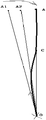
- FIG. 2 is a schematic diagram of a flight path of a drone in an embodiment of a method for controlling flight of a drone according to an alternative embodiment of the present invention
- FIG. 3 is a structural block diagram of an embodiment of an apparatus for controlling flight of a drone according to an embodiment of the present invention.
- FIG. 1 a flow chart of steps of an embodiment of a method for controlling flight of a drone according to the present invention is shown, which may specifically include the following steps:
- Step 101 Determine an initial flight position and a head direction in which the drone currently stays;
- the starting flight location may be where the drone currently resides.
- a position can be pre-defined as the dwelling position of the drone, that is, the position where the drone is stopped. If the drone is not in the pre-defined parking position, the operator can place or fly the drone to the parked position.
- the initial flight position of the drone and the head direction of the drone can be detected by a positioning device on the drone, such as a compass instrument, a GPS positioning system, and the like.
- the initial flight position of the drone can be expressed in latitude and longitude, and the head direction of the drone can be represented by the heading angle.
- the method may further include the steps of: receiving the input flight speed parameter and the flight distance parameter.
- the flight speed parameter and the flight distance parameter required for the current operation may be first input through the remote control device.
- the flight speed parameter specifies the flight speed at which the drone is operating.
- the flight distance parameter refers to the linear distance that the UAV needs to fly when it is operating.
- the remote control device may send the flight speed parameter and the flight distance parameter to the drone through the communication module.
- the remote control device may be a device with a touch screen display, or other remote controllers having physical input buttons and other functional physical buttons, which are not limited in this embodiment of the present invention.
- Step 102 Starting from the initial flight position, flying straight along the direction of the nose;
- the drone determines the starting flight position of the current stop and the direction of the head of the drone, when starting the work, it can start from the starting flight position and fly straight along the direction of the nose of the drone.
- step 102 may further be: starting from the initial flight position, flying in a straight line along the direction of the nose according to the speed specified by the speed parameter.
- the flight path determined by the drone may be: starting with the starting flight position as the starting point A ray from the head of the drone is used as a flight path.
- the drone can define a virtual point on the straight line along the head of the drone, as the end point, and use the straight line determined by the starting point and the ending point as the flight path. .
- the operator can place or fly the aircraft to the O point and adjust the direction of the nose, assuming that the head direction is toward the A1 point, then no one
- the machine can use the straight line composed of OA1 as the flight route.
- the drone after determining the flight route, the drone can have the ability to fly along a straight flight path, and when the drone deviates from the straight flight path, it can return to the straight line as soon as possible, thereby Keep a small deviation.
- Step 103 If a route adjustment command is received during the flight, the route of the drone is adjusted based on the route adjustment command.
- the deviation of the head direction is likely to be manually adjusted, so that the direction of the head cannot be accurately aligned with the direction desired by the operator, resulting in the determination of the drone.
- the flight route is inconsistent with the flight route actually required by the operator. For example, as shown in FIG. 2, it is assumed that the flight path actually required by the operator is a straight line composed of OA, and when the operator adjusts the direction of the nose, the head direction is aligned.
- the point A1 is such that the flight path determined by the drone is a straight line composed of the OA1, which deviates from the route OA that the operator actually needs to fly.
- the operator can issue a route adjustment command to the drone through the remote control device, and the drone can automatically adjust the route during the flight of the drone based on the route adjustment command.
- the route adjustment command issued by the operator can be used to notify the drone from point A1 toward point A.
- the drone can converge toward point A according to the route adjustment command after receiving the route adjustment command.
- the remote control device may generate a route adjustment command in the following manner:
- Detecting a route adjustment operation performed by an operator in the remote control device determining a route adjustment direction and/or a route adjustment range corresponding to the route adjustment operation; and generating a route adjustment instruction based on the route adjustment direction and/or the route adjustment range.
- the route adjustment operation can be issued through the remote control device.
- the route adjustment operation may include an operator sliding operation of the touchscreen slider in the remote control device.
- the touch screen slider can be displayed in the control panel of the control device in the form of a progress bar. When the operator slides the progress bar, it is determined that the operator initiates the route adjustment operation.
- the touch screen slider can be displayed in a horizontal direction.
- the operator wants to control the drone to shift to the left.
- the operator slides to the right the operator wants to Control the drone to shift to the right.
- the touch screen slider can be divided into a plurality of small cells, and each small cell preset corresponds to an offset amplitude of the drone, and according to the number of small cells that the operator slides on the touch screen slider, Determine the magnitude of the drone offset, which is the distance the drone deviates from the current location.
- the route adjustment operation may include an operator clicking operation on a physical direction button in the remote control device.
- the operator can also trigger the route adjustment operation through the physical direction button in the remote control device.
- the remote control device there may be physical direction buttons in four directions of up, down, left, and right.
- the operator clicks the physical button in the left direction the operator wants to control the drone to shift to the left when operating.
- the operator clicks on the physical button in the right direction the operator wants to control the drone to shift to the right.
- the offset amplitude of the corresponding drone can be set in advance, and the amplitude of the drone offset can be determined according to the number of clicks of the operator in the same direction in the remote control device, that is, the drone deviates from the current The distance from the location.
- the route adjustment operation may further include an operator's touch operation on the touch screen direction button in the remote control device, that is, the physical directions of the upper, lower, left, and right directions in the previous embodiment.
- the direction button can be set as a virtual button to be displayed in the control interface of the remote control device. When the operator clicks the virtual button in the left direction, the operator wants to control the drone to shift to the left. When the operator clicks the virtual button in the right direction, the operator wants to control the drone to shift to the right.
- the offset amplitude of the corresponding drone can be set in advance, and the amplitude of the drone offset can be determined according to the number of clicks of the operator in the same direction in the remote control device, that is, the drone deviates from the current The distance from the location.
- the route adjustment operation may further include an operator moving the control rocker in the remote control device.
- the operator moves the control joystick to the left, the operator wants to control the drone to Left offset, when the operator moves the control stick to the right, the operator wants to control the drone to shift to the right.
- the offset amplitude of the mobile joystick corresponding to the drone can also be set in advance, and the amplitude of the drone offset can be determined according to the number of movements of the operator in the same direction in the remote control device, that is, the drone The distance from the current location.
- the remote control device detects the route adjustment operation performed by the operator in the remote control device
- the movement direction and the movement distance of the operator for the touch screen slider, or the direction of the physical direction button or the virtual direction button and the number of clicks may be used.
- the route adjustment direction and/or the route adjustment range corresponding to the route adjustment operation are determined for the moving direction of the joystick and the number of movements.
- the movement direction corresponding to the route adjustment operation can be obtained as the left direction, and the route adjustment range is 5 meters.
- the route adjustment instruction may be generated according to the route adjustment direction and/or the route adjustment range, and the route is adjusted.
- the command is sent to the drone through the communication module, and the drone can adjust the route according to the route adjustment direction and/or the route adjustment range.
- the remote control device may generate the route adjustment command only according to the route adjustment direction, and after receiving the route adjustment command, the drone is offset from the route adjustment direction by a preset amplitude.
- the remote control device may generate a route adjustment command according to the route adjustment direction and the route adjustment range, and after receiving the route adjustment command, the drone shifts the distance corresponding to the route adjustment range to the route adjustment direction.
- the drone shifts the distance corresponding to the route adjustment range to the route adjustment direction.
- the route that the user needs to operate the drone is an OA straight line, but due to the operation error, the operator aligns the head of the drone with the A1 direction, and the flight path determined by the drone is OA1 straight line, and along The OA1 flies in a straight line direction.
- the operator finds that the drone does not fly along the OA direction, and determines that it is a deviation route.
- the operator can send a route adjustment command to the right by the remote control device, for example, After shifting to the A2 point, the drone moves to the A2 position after receiving the route adjustment command, so that the drone flies in a straight line toward the O-A2 direction, and the operator continuously corrects the route according to the above method, when the drone is biased When moving to point C of Fig. 2, it starts to fly in the direction of CA.
- the bolded portion is the flight path of the drone's current work.
- step 103 may include the following sub-steps:
- Sub-step S11 if a route adjustment instruction is received during the flight, the drone is flew to the reference point based on the route adjustment direction and the route adjustment range;
- the route adjustment direction carried in the command and the route adjustment range may be adjusted according to the route, or according to the route adjustment instruction
- the direction of the carried route and the preset route adjustment range will fly the drone to the reference point, which is point C in Figure 2.
- Sub-step S12 acquiring coordinates of the reference point
- the drone After determining the reference point, the drone can obtain the reference point through the positioning device in the drone.
- the coordinates as shown in Figure 2, the coordinates of point C.
- Sub-step S13 determining a coordinate of the target point based on the direction angle determined by the initial flight position and the coordinates of the reference point, and the flight distance parameter;
- the direction angle between the two can be determined.
- the target point can be calculated. coordinate of.
- the direction angle of the OC can be determined, and then the coordinates of the point A can be obtained according to the direction angle of the OC, the coordinates of the O point, and the flight distance parameter.
- Sub-step S14 obtaining a heading angle of the drone in real time
- the drone's own compass can obtain the real-time heading angle of the drone.
- Sub-step S15 calculating a route deviation according to the direction angle determined by the initial flight position and the coordinates of the reference point and the heading angle;
- the difference between the two can be calculated as the route deviation.
- Sub-step S16 controlling the drone to be aligned with the target point based on the route deviation
- the real-time heading angle is added to the route deviation, and the actual flight angle can be obtained. Then, the nose direction of the drone can be adjusted to align with the actual flight angle, so that the drone Align the target point.
- Sub-step S17 calculating a distance between the reference point and the target point, and controlling the drone to fly to the target point.
- the distance between the reference point and the target point can be calculated as the remaining distance of the current flight route, and then the drone can be controlled to fly the remaining distance according to the speed specified by the flight speed parameter.
- step 103 may include the following sub-steps:
- Sub-step S21 if a route adjustment instruction is received during flight, the drone is flew to the reference point based on the route adjustment direction and the route adjustment range;
- Sub-step S22 acquiring coordinates of the reference point
- Sub-step S23 acquiring a heading angle of the drone in real time
- Sub-step S24 calculating a course deviation based on the direction angle determined by the initial flight position and the coordinates of the reference point, and the heading angle of the drone in real time;
- Sub-step S25 controlling, according to the route deviation, a direction in which the drone is aligned with the direction angle determined by the coordinates of the initial flight position and the reference point;
- Sub-step S26 calculating a distance between the initial flight position and the reference point
- Sub-step S27 controlling the drone flight based on the flight distance parameter and the remaining distance determined by the distance between the initial flight position and the reference point.
- the embodiment of sub-step S21 - sub-step S27 is different from the embodiment of sub-step S11 - sub-step S17 described above, except that the coordinates of the target point are not exactly obtained in the embodiment, and the calculation of the route deviation is based on The direction angle determined by the coordinates of the initial flight position and the reference point, and the difference of the heading angle of the UAV in real time, determine the route deviation, and after obtaining the route deviation, the real-time heading angle is added to the route deviation, then Obtain the angle of the actual flight path, and then adjust the nose direction of the drone to the angle of the actual flight path.
- the actual flight path angle is the vector determined by the coordinates of the starting flight position and the reference point. direction.
- the drone When calculating the remaining distance, first calculate the distance traveled between the starting flight position and the reference point, and then calculate the remaining distance according to the difference between the flight distance parameter and the distance of the flight, and then, the drone can be controlled according to The speed specified by the flight speed parameter flies the remaining distance.
- the drone when the drone determines the starting flight position and the direction of the head of the drone, it can directly fly from the starting flight position and fly straight along the direction of the nose. During the flight, If the drone receives the route adjustment command, the route of the drone can be adjusted based on the route adjustment command. At least some embodiments of the present invention combine the manual fine adjustment correction and the automatic navigation of the drone to make the drone follow the operator.
- the required straight-line flight can be used to correct the route through the remote control device when the operator detects that the drone flight deviates from the route during the flight without the mapping. The operator can simply operate the operation. Let the drone fly precisely along the desired line, simplifying the operation and improving the resilience of the drone.
- FIG. 3 a block diagram of an embodiment of an apparatus for controlling flight of a drone of the present invention is shown, which may include the following modules:
- the information determining module 301 is configured to determine an initial flight position and a head direction in which the drone is currently staying;
- a flight module 302 configured to fly straight from the starting flight position along the direction of the nose
- the direction adjustment module 303 is configured to adjust the route of the drone based on the route adjustment command if a route adjustment command is received during flight.
- the apparatus further includes:
- the parameter receiving module is configured to receive the input flight speed parameter and the flight distance parameter.
- the flight module 302 is further configured to:
- a straight flight is performed along the direction of the nose in accordance with the speed specified by the speed parameter.
- the route adjustment command is an instruction issued by the remote control device, and the remote control device generates a route adjustment command in the following manner:
- a route adjustment command is generated based on the route adjustment direction and/or the route adjustment range.
- the route adjustment operation includes at least one of the following operations:
- the operator moves the control rocker in the remote control device
- the direction adjustment module 303 includes:
- a first reference point flight submodule configured to, when receiving a route adjustment command during flight, fly the drone to a reference point based on the route adjustment direction and the route adjustment range;
- a first reference point coordinate acquisition submodule configured to acquire coordinates of the reference point
- a target point coordinate determining submodule configured to determine a coordinate of the target point based on a direction angle determined by a starting flight position and coordinates of the reference point, and the flight distance parameter;
- a first real-time heading angle acquisition sub-module configured to obtain a real-time heading angle of the drone
- a first route deviation calculation submodule configured to calculate a route deviation according to a direction angle determined by the initial flight position and coordinates of the reference point and the heading angle
- a first direction alignment sub-module configured to control the drone to be aligned with the target point based on the route deviation
- the first flight control submodule is configured to calculate a distance between the reference point and the target point, and control the drone to fly to the target point.
- the direction adjustment module includes:
- a second reference point flight submodule configured to, when receiving a route adjustment command during flight, fly the drone to the reference point based on the route adjustment direction and the route adjustment range;
- a second reference point coordinate acquisition submodule configured to acquire coordinates of the reference point
- a second real-time heading angle acquisition sub-module configured to acquire a real-time heading angle of the drone
- a second route deviation calculation sub-module configured to calculate a route deviation based on a direction angle determined by a starting flight position and coordinates of the reference point, and a heading angle of the drone in real time;
- a second direction alignment submodule configured to control a direction in which the drone is aligned with the direction angle determined by the coordinates of the initial flight position and the reference point based on the route deviation
- a distance calculation submodule configured to calculate a distance between the initial flight position and the reference point
- a second flight control sub-module configured to control the drone flight based on the flight distance parameter and a remaining distance determined by a distance between the initial flight location and the reference point.
- At least some embodiments of the present invention can be provided as a method, apparatus, or computer program product.
- at least some of the embodiments of the present invention can be in the form of an entirely hardware embodiment, an entirely software embodiment, or a combination of software and hardware.
- at least some embodiments of the present invention can employ a computer program product embodied on one or more computer usable storage media (including but not limited to disk storage, CD-ROM, optical storage, etc.) having computer usable program code embodied therein. form.
- the computer program instructions can also be stored in a computer readable memory that can direct a computer or other programmable data processing terminal device to operate in a particular manner, such that the instructions stored in the computer readable memory produce an article of manufacture comprising the instruction device.
- the instruction device implements the functions specified in one or more blocks of the flowchart or in a flow or block of the flowchart.
- At least some embodiments of the present invention provide a method for controlling flight of a drone and a corresponding device for controlling flight of the drone having the following beneficial effects: combining manual fine adjustment correction and automatic navigation of the drone
- the UAV can fly along the straight line that the operator wants, and can correct the route through the remote control device when the operator detects that the UAV flies off the route without flying and mapping.
- the operator can make the drone accurately fly along the desired line with a simple operation, which simplifies the operation process and improves the resilience of the drone.
Landscapes
- Engineering & Computer Science (AREA)
- Physics & Mathematics (AREA)
- General Physics & Mathematics (AREA)
- Radar, Positioning & Navigation (AREA)
- Remote Sensing (AREA)
- Aviation & Aerospace Engineering (AREA)
- Automation & Control Theory (AREA)
- Theoretical Computer Science (AREA)
- General Engineering & Computer Science (AREA)
- Human Computer Interaction (AREA)
- Computing Systems (AREA)
- Mathematical Physics (AREA)
- Control Of Position, Course, Altitude, Or Attitude Of Moving Bodies (AREA)
Abstract
Description
Claims (14)
- 一种控制无人机飞行的方法,所述方法包括:确定无人机当前所停留的起始飞行位置以及机头方向;从所述起始飞行位置出发,沿着所述机头方向直线飞行;在飞行过程中,若接收到路线调节指令,基于所述路线调节指令调节所述无人机的航线。
- 根据权利要求1所述的方法,其中,在所述确定无人机当前所停留的起始飞行位置以及机头方向的步骤之前,还包括:接收输入的飞行速度参数以及飞行距离参数。
- 根据权利要求2所述的方法,其中,所述从所述起始飞行位置出发,沿着所述机头方向直线飞行的步骤为:从所述起始飞行位置出发,沿着所述机头方向按照所述速度参数所指定的速度直线飞行。
- 根据权利要求2或3所述的方法,其中,所述路线调节指令为遥控装置发出的指令,所述遥控装置采用如下方式生成路线调节指令:检测操作人员在遥控装置中执行的航线调整操作;确定所述航线调整操作对应的航线调整方向和/或航线调整幅度;基于所述航线调整方向和/或航线调整幅度生成路线调节指令。
- 根据权利要求4所述的方法,其中,所述航线调整操作至少包括如下操作的一种:操作人员对遥控装置中的触屏滑条的滑动操作;操作人员对遥控装置中的物理方向按钮的点击操作;操作人员对遥控装置中的控制摇杆的移动操作;操作人员对遥控装置中的触屏方向按钮的点触操作。
- 根据权利要求4所述的方法,其中,所述在飞行过程中,若接收到路线调节指令,基于所述路线调节指令调节所述无人机的航线的步骤包括:在飞行过程中,若接收到路线调节指令,基于所述航线调整方向以及所述航线调整幅度将无人机飞行至参考点;获取所述参考点的坐标;基于起始飞行位置与所述参考点的坐标所确定的方向角,以及所述飞行距离参数,确定目标点的坐标;获取无人机实时的航向角;依据所述起始飞行位置与所述参考点的坐标所确定的方向角以及所述航向角,计算航线偏差;基于所述航线偏差,控制无人机对准所述目标点;计算所述参考点与所述目标点之间的距离,控制所述无人机飞向所述目标点。
- 根据权利要求4所述的方法,其中,所述在飞行过程中,若接收到路线调节指令,基于所述路线调节指令调节所述无人机的航线的步骤包括:在飞行过程中,若接收到路线调节指令,基于所述航线调整方向以及所述航线调整幅度将无人机飞行至参考点;获取所述参考点的坐标;获取无人机实时的航向角;基于起始飞行位置与所述参考点的坐标所确定的方向角,以及所述无人机实时的航向角,计算航线偏差;基于所述航线偏差,控制无人机对准所述起始飞行位置与所述参考点的坐标所确定的方向角的方向;计算所述起始飞行位置与所述参考点之间的距离;基于所述飞行距离参数以及所述起始飞行位置与所述参考点之间的距离所确定的剩余距离,控制所述无人机飞行。
- 一种控制无人机飞行的装置,所述装置包括:信息确定模块,设置为确定无人机当前所停留的起始飞行位置以及机头方向;飞行模块,设置为从所述起始飞行位置出发,沿着所述机头方向直线飞行;方向调节模块,设置为在飞行过程中,若接收到路线调节指令,基于所 述路线调节指令调节所述无人机的航线。
- 根据权利要求8所述的装置,其中,还包括:参数接收模块,设置为接收输入的飞行速度参数以及飞行距离参数。
- 根据权利要求9所述的装置,其中,所述飞行模块还设置为:从所述起始飞行位置出发,沿着所述机头方向按照所述速度参数所指定的速度直线飞行。
- 根据权利要求9或10所述的装置,其中,所述路线调节指令为遥控装置发出的指令,所述遥控装置采用如下方式生成路线调节指令:检测操作人员在遥控装置中执行的航线调整操作;确定所述航线调整操作对应的航线调整方向和/或航线调整幅度;基于所述航线调整方向和/或航线调整幅度生成路线调节指令。
- 根据权利要求11所述的装置,其中,所述航线调整操作至少包括如下操作的一种:操作人员对遥控装置中的触屏滑条的滑动操作;操作人员对遥控装置中的物理方向按钮的点击操作;操作人员对遥控装置中的控制摇杆的移动操作;操作人员对遥控装置中的触屏方向按钮的点触操作。
- 根据权利要求11所述的装置,其中,所述方向调节模块包括:第一参考点飞行子模块,设置为在飞行过程中,若接收到路线调节指令,基于所述航线调整方向以及所述航线调整幅度将无人机飞行至参考点;第一参考点坐标获取子模块,设置为获取所述参考点的坐标;目标点坐标确定子模块,设置为基于起始飞行位置与所述参考点的坐标所确定的方向角,以及所述飞行距离参数,确定目标点的坐标;第一实时航向角获取子模块,设置为获取无人机实时的航向角;第一航线偏差计算子模块,设置为依据所述起始飞行位置与所述参考点的坐标所确定的方向角以及所述航向角,计算航线偏差;第一方向对准子模块,设置为基于所述航线偏差,控制无人机对准所述目标点;第一飞行控制子模块,设置为计算所述参考点与所述目标点之间的距离,控制所述无人机飞向所述目标点。
- 根据权利要求11所述的装置,其中,所述方向调节模块包括:第二参考点飞行子模块,设置为在飞行过程中,若接收到路线调节指令,基于所述航线调整方向以及所述航线调整幅度将无人机飞行至参考点;第二参考点坐标获取子模块,设置为获取所述参考点的坐标;第二实时航向角获取子模块,设置为获取无人机实时的航向角;第二航线偏差计算子模块,设置为基于起始飞行位置与所述参考点的坐标所确定的方向角,以及所述无人机实时的航向角,计算航线偏差;第二方向对准子模块,设置为基于所述航线偏差,控制无人机对准所述起始飞行位置与所述参考点的坐标所确定的方向角的方向;距离计算子模块,设置为计算所述起始飞行位置与所述参考点之间的距离;第二飞行控制子模块,设置为基于所述飞行距离参数以及所述起始飞行位置与所述参考点之间的距离所确定的剩余距离,控制所述无人机飞行。
Priority Applications (9)
| Application Number | Priority Date | Filing Date | Title |
|---|---|---|---|
| PL17873557T PL3547066T3 (pl) | 2016-11-28 | 2017-11-24 | Sposób i urządzenie do sterowania lotem bezzałogowego statku powietrznego |
| JP2019548513A JP6882505B2 (ja) | 2016-11-28 | 2017-11-24 | 無人機の飛行を制御するための方法及び装置 |
| EP17873557.7A EP3547066B1 (en) | 2016-11-28 | 2017-11-24 | Method and apparatus for controlling flight of unmanned aerial vehicle |
| ES17873557T ES2913548T3 (es) | 2016-11-28 | 2017-11-24 | Procedimiento y aparato para controlar el vuelo de un vehículo aéreo no tripulado |
| AU2017366538A AU2017366538B2 (en) | 2016-11-28 | 2017-11-24 | Method and apparatus for controlling flight of unmanned aerial vehicle |
| RU2019116801A RU2715104C1 (ru) | 2016-11-28 | 2017-11-24 | Способ и устройство управления полетом беспилотного летательного аппарата |
| US16/462,847 US11498676B2 (en) | 2016-11-28 | 2017-11-24 | Method and apparatus for controlling flight of unmanned aerial vehicle |
| KR1020197015233A KR102296455B1 (ko) | 2016-11-28 | 2017-11-24 | 무인기의 비행을 제어하는 방법 및 장치 |
| CA3051668A CA3051668C (en) | 2016-11-28 | 2017-11-24 | Method and apparatus for controlling flight of unmanned aerial vehicle |
Applications Claiming Priority (2)
| Application Number | Priority Date | Filing Date | Title |
|---|---|---|---|
| CN201611070426.X | 2016-11-28 | ||
| CN201611070426.XA CN106444848B (zh) | 2016-11-28 | 2016-11-28 | 控制无人机飞行的方法及装置 |
Publications (1)
| Publication Number | Publication Date |
|---|---|
| WO2018095407A1 true WO2018095407A1 (zh) | 2018-05-31 |
Family
ID=58219447
Family Applications (1)
| Application Number | Title | Priority Date | Filing Date |
|---|---|---|---|
| PCT/CN2017/112862 Ceased WO2018095407A1 (zh) | 2016-11-28 | 2017-11-24 | 控制无人机飞行的方法及装置 |
Country Status (12)
| Country | Link |
|---|---|
| US (1) | US11498676B2 (zh) |
| EP (1) | EP3547066B1 (zh) |
| JP (1) | JP6882505B2 (zh) |
| KR (1) | KR102296455B1 (zh) |
| CN (1) | CN106444848B (zh) |
| AU (1) | AU2017366538B2 (zh) |
| CA (1) | CA3051668C (zh) |
| ES (1) | ES2913548T3 (zh) |
| HU (1) | HUE058659T2 (zh) |
| PL (1) | PL3547066T3 (zh) |
| RU (1) | RU2715104C1 (zh) |
| WO (1) | WO2018095407A1 (zh) |
Cited By (3)
| Publication number | Priority date | Publication date | Assignee | Title |
|---|---|---|---|---|
| CN110244765A (zh) * | 2019-06-27 | 2019-09-17 | 深圳市道通智能航空技术有限公司 | 一种飞行器航线轨迹生成方法、装置、无人机及存储介质 |
| CN111699454A (zh) * | 2019-05-27 | 2020-09-22 | 深圳市大疆创新科技有限公司 | 一种飞行规划方法及相关设备 |
| CN111766897A (zh) * | 2020-07-10 | 2020-10-13 | 广东电网有限责任公司 | 一种输电线路的通道巡视方法、无人机和系统 |
Families Citing this family (25)
| Publication number | Priority date | Publication date | Assignee | Title |
|---|---|---|---|---|
| CN106444848B (zh) | 2016-11-28 | 2018-11-30 | 广州极飞科技有限公司 | 控制无人机飞行的方法及装置 |
| CN108885464A (zh) * | 2017-02-28 | 2018-11-23 | 深圳市大疆创新科技有限公司 | 航线修正的方法、设备和无人机 |
| CN108628336B (zh) * | 2017-03-16 | 2020-12-18 | 广州极飞科技有限公司 | 无人机的飞行控制方法、装置和无人机 |
| CN108496136A (zh) * | 2017-05-24 | 2018-09-04 | 深圳市大疆创新科技有限公司 | 无人飞行器的返航控制方法、设备及无人飞行器 |
| CN107255827A (zh) * | 2017-07-06 | 2017-10-17 | 杨顺伟 | 一种无人机的景点导航方法及装置 |
| CN114141060A (zh) * | 2017-09-28 | 2022-03-04 | 联想(北京)有限公司 | 用于控制空中ue的操作的方法和装置 |
| CN110007685A (zh) * | 2018-01-04 | 2019-07-12 | 西安远智电子科技有限公司 | 航线调整方法及装置 |
| CN111007868A (zh) * | 2018-10-08 | 2020-04-14 | 成都新越科技有限公司 | 一种无人机自主管控方法 |
| CN109062259A (zh) * | 2018-10-31 | 2018-12-21 | 西安天问智能科技有限公司 | 一种无人机自动避障方法及其装置 |
| CN110109475A (zh) * | 2019-05-20 | 2019-08-09 | 深圳市道通智能航空技术有限公司 | 一种无人机控制方法与装置、计算机可读存储介质 |
| CN110595039A (zh) * | 2019-08-21 | 2019-12-20 | 青岛海尔空调器有限总公司 | 空调器的导风板控制装置 |
| JP7609072B2 (ja) * | 2019-09-06 | 2025-01-07 | 日本電気株式会社 | 第1の無線局、第2の無線局、コアネットワークノード、移動端末、システム、方法、及びコンピュータに読み取り可能な非一時的記録媒体 |
| CN111752296B (zh) * | 2019-09-30 | 2024-07-09 | 广州极飞科技股份有限公司 | 无人机航线控制方法及相关装置 |
| CN110989662B (zh) * | 2019-11-20 | 2022-08-30 | 中山飞旋天行航空科技有限公司 | 一种植保无人机转弯路径的飞行控制方法 |
| US12498731B2 (en) | 2019-12-17 | 2025-12-16 | Kt Corporation | Method and device for setting drone flight path |
| CN111272148B (zh) * | 2020-01-20 | 2021-08-31 | 江苏方天电力技术有限公司 | 输电线路无人机自主巡检自适应成像质量优化方法 |
| CN111580531B (zh) * | 2020-04-27 | 2023-06-09 | 瑞凯星弘(武汉)科技有限公司 | 用于输电线路的无人机验电方法及装置 |
| RU2734171C1 (ru) * | 2020-04-29 | 2020-10-13 | Акционерное общество "Уральское производственное предприятие "Вектор" (АО "УПП "Вектор") | Способ оптимальной адаптации маршрута перехвата воздушной цели при нахождении в районе полетов группировки зенитных ракетных комплексов |
| US20230030222A1 (en) * | 2021-07-29 | 2023-02-02 | Teledyne Flir Detection, Inc. | Operating modes and video processing for mobile platforms |
| US12061471B2 (en) * | 2022-03-01 | 2024-08-13 | Logistics and Supply Chain MultiTech R&D Centre Limited | Wearable remote control device and tracking system |
| CN114879725A (zh) * | 2022-04-27 | 2022-08-09 | 山东省地质测绘院 | 一种无人机控制系统及无人机控制方法 |
| CN115657555A (zh) * | 2022-10-25 | 2023-01-31 | 广州极飞科技股份有限公司 | 遥控设备辅助作业方法、装置、遥控设备和存储介质 |
| GB2626725A (en) * | 2023-01-18 | 2024-08-07 | Samsung Electronics Co Ltd | Reporting to network a deviation from planned path |
| CN116301039A (zh) * | 2023-02-28 | 2023-06-23 | 北京机械设备研究所 | 一种车载式消防无人机协同作业控制系统及方法 |
| CN116499436B (zh) * | 2023-05-11 | 2023-12-15 | 姜鸿力 | 一种工程造价测绘系统及测绘方法 |
Citations (7)
| Publication number | Priority date | Publication date | Assignee | Title |
|---|---|---|---|---|
| US20120239232A1 (en) * | 2009-10-20 | 2012-09-20 | Peder Solheim | Method for Determining Correction Under Steering of a Point on a Towed Object towards a Goal Position |
| CN104670496A (zh) * | 2015-03-11 | 2015-06-03 | 西南大学 | 一种六轴式农药喷雾飞行装置及控制方法 |
| CN104932526A (zh) * | 2015-05-29 | 2015-09-23 | 深圳市大疆创新科技有限公司 | 一种飞行设备的控制方法及飞行设备 |
| CN105022398A (zh) * | 2015-07-15 | 2015-11-04 | 何春旺 | 触摸屏控制器及行驶装置的控制方法 |
| CN105045281A (zh) * | 2015-08-13 | 2015-11-11 | 深圳一电科技有限公司 | 无人机飞行控制方法及装置 |
| CN105867424A (zh) * | 2016-06-07 | 2016-08-17 | 广州极飞电子科技有限公司 | 航线编辑处理方法和装置 |
| CN106444848A (zh) * | 2016-11-28 | 2017-02-22 | 广州极飞科技有限公司 | 控制无人机飞行的方法及装置 |
Family Cites Families (19)
| Publication number | Priority date | Publication date | Assignee | Title |
|---|---|---|---|---|
| US8200375B2 (en) | 2008-02-12 | 2012-06-12 | Stuckman Katherine C | Radio controlled aircraft, remote controller and methods for use therewith |
| US20090306840A1 (en) * | 2008-04-08 | 2009-12-10 | Blenkhorn Kevin P | Vision-based automated landing system for unmanned aerial vehicles |
| DE102011010679A1 (de) * | 2011-02-08 | 2012-08-09 | Eads Deutschland Gmbh | Unbemanntes Luftfahrzeug mit eingebautem Kollisionswarnsystem |
| US20140018979A1 (en) | 2012-07-13 | 2014-01-16 | Honeywell International Inc. | Autonomous airspace flight planning and virtual airspace containment system |
| CN103149937B (zh) * | 2013-02-26 | 2015-10-21 | 北京航空航天大学 | 一种基于曲率补偿的横侧向曲线航迹跟踪方法 |
| RU2537124C1 (ru) * | 2013-07-11 | 2014-12-27 | Открытое акционерное общество "Конструкторское бюро приборостроения им. академика А.Г. Шипунова" | Способ телеуправления ракетой |
| JP5870171B1 (ja) | 2014-08-18 | 2016-02-24 | ヤマハ発動機株式会社 | 遠隔操縦装置 |
| US9618934B2 (en) * | 2014-09-12 | 2017-04-11 | 4D Tech Solutions, Inc. | Unmanned aerial vehicle 3D mapping system |
| WO2016041110A1 (zh) * | 2014-09-15 | 2016-03-24 | 深圳市大疆创新科技有限公司 | 一种飞行器的飞行控制方法及相关装置 |
| RU155323U1 (ru) * | 2014-12-11 | 2015-09-27 | Закрытое акционерное общество "МНИТИ" (ЗАО "МНИТИ") | Система управления беспилотным летательным аппаратом |
| WO2017003538A2 (en) * | 2015-04-14 | 2017-01-05 | Tobin Fisher | System for authoring, executing, and distributing unmanned aerial vehicle flight-behavior profiles |
| CN119645078A (zh) * | 2015-09-15 | 2025-03-18 | 深圳市大疆创新科技有限公司 | 控制可移动物体跟踪目标的系统和方法 |
| US10008123B2 (en) * | 2015-10-20 | 2018-06-26 | Skycatch, Inc. | Generating a mission plan for capturing aerial images with an unmanned aerial vehicle |
| CN105302158B (zh) | 2015-10-23 | 2018-05-22 | 南京航空航天大学 | 基于Dubins路径的无人机空中加油最短时间会合方法 |
| US10762795B2 (en) * | 2016-02-08 | 2020-09-01 | Skydio, Inc. | Unmanned aerial vehicle privacy controls |
| CN105955291B (zh) * | 2016-04-29 | 2021-04-27 | 深圳市哈博森科技有限公司 | 一种无人机飞行航线轨迹记录与自动飞行控制方式 |
| US11263909B2 (en) * | 2016-06-10 | 2022-03-01 | Metal Raptor, Llc | Air traffic control of passenger drones concurrently using a plurality of wireless networks |
| US10189566B2 (en) * | 2016-06-10 | 2019-01-29 | ETAK Systems, LLC | 3D coverage mapping of wireless networks with unmanned aerial vehicles |
| CN105867407A (zh) * | 2016-06-12 | 2016-08-17 | 零度智控(北京)智能科技有限公司 | 无人机、无人机飞行控制装置及方法 |
-
2016
- 2016-11-28 CN CN201611070426.XA patent/CN106444848B/zh active Active
-
2017
- 2017-11-24 EP EP17873557.7A patent/EP3547066B1/en active Active
- 2017-11-24 RU RU2019116801A patent/RU2715104C1/ru active
- 2017-11-24 AU AU2017366538A patent/AU2017366538B2/en not_active Ceased
- 2017-11-24 ES ES17873557T patent/ES2913548T3/es active Active
- 2017-11-24 JP JP2019548513A patent/JP6882505B2/ja not_active Expired - Fee Related
- 2017-11-24 US US16/462,847 patent/US11498676B2/en active Active
- 2017-11-24 KR KR1020197015233A patent/KR102296455B1/ko not_active Expired - Fee Related
- 2017-11-24 WO PCT/CN2017/112862 patent/WO2018095407A1/zh not_active Ceased
- 2017-11-24 PL PL17873557T patent/PL3547066T3/pl unknown
- 2017-11-24 CA CA3051668A patent/CA3051668C/en active Active
- 2017-11-24 HU HUE17873557A patent/HUE058659T2/hu unknown
Patent Citations (7)
| Publication number | Priority date | Publication date | Assignee | Title |
|---|---|---|---|---|
| US20120239232A1 (en) * | 2009-10-20 | 2012-09-20 | Peder Solheim | Method for Determining Correction Under Steering of a Point on a Towed Object towards a Goal Position |
| CN104670496A (zh) * | 2015-03-11 | 2015-06-03 | 西南大学 | 一种六轴式农药喷雾飞行装置及控制方法 |
| CN104932526A (zh) * | 2015-05-29 | 2015-09-23 | 深圳市大疆创新科技有限公司 | 一种飞行设备的控制方法及飞行设备 |
| CN105022398A (zh) * | 2015-07-15 | 2015-11-04 | 何春旺 | 触摸屏控制器及行驶装置的控制方法 |
| CN105045281A (zh) * | 2015-08-13 | 2015-11-11 | 深圳一电科技有限公司 | 无人机飞行控制方法及装置 |
| CN105867424A (zh) * | 2016-06-07 | 2016-08-17 | 广州极飞电子科技有限公司 | 航线编辑处理方法和装置 |
| CN106444848A (zh) * | 2016-11-28 | 2017-02-22 | 广州极飞科技有限公司 | 控制无人机飞行的方法及装置 |
Non-Patent Citations (1)
| Title |
|---|
| See also references of EP3547066A4 * |
Cited By (5)
| Publication number | Priority date | Publication date | Assignee | Title |
|---|---|---|---|---|
| CN111699454A (zh) * | 2019-05-27 | 2020-09-22 | 深圳市大疆创新科技有限公司 | 一种飞行规划方法及相关设备 |
| CN111699454B (zh) * | 2019-05-27 | 2024-04-12 | 深圳市大疆创新科技有限公司 | 一种飞行规划方法及相关设备 |
| CN110244765A (zh) * | 2019-06-27 | 2019-09-17 | 深圳市道通智能航空技术有限公司 | 一种飞行器航线轨迹生成方法、装置、无人机及存储介质 |
| CN111766897A (zh) * | 2020-07-10 | 2020-10-13 | 广东电网有限责任公司 | 一种输电线路的通道巡视方法、无人机和系统 |
| CN111766897B (zh) * | 2020-07-10 | 2024-02-27 | 广东电网有限责任公司 | 一种输电线路的通道巡视方法、无人机和系统 |
Also Published As
| Publication number | Publication date |
|---|---|
| EP3547066B1 (en) | 2022-05-04 |
| CA3051668A1 (en) | 2018-05-31 |
| CN106444848B (zh) | 2018-11-30 |
| JP2019537182A (ja) | 2019-12-19 |
| EP3547066A1 (en) | 2019-10-02 |
| AU2017366538B2 (en) | 2020-06-18 |
| EP3547066A4 (en) | 2020-06-17 |
| PL3547066T3 (pl) | 2022-06-13 |
| US20200062394A1 (en) | 2020-02-27 |
| AU2017366538A1 (en) | 2019-06-13 |
| HUE058659T2 (hu) | 2022-09-28 |
| ES2913548T3 (es) | 2022-06-02 |
| KR20190077030A (ko) | 2019-07-02 |
| JP6882505B2 (ja) | 2021-06-02 |
| US11498676B2 (en) | 2022-11-15 |
| RU2715104C1 (ru) | 2020-02-25 |
| CN106444848A (zh) | 2017-02-22 |
| CA3051668C (en) | 2022-01-11 |
| KR102296455B1 (ko) | 2021-09-02 |
Similar Documents
| Publication | Publication Date | Title |
|---|---|---|
| WO2018095407A1 (zh) | 控制无人机飞行的方法及装置 | |
| US10831186B2 (en) | System for authoring, executing, and distributing unmanned aerial vehicle flight-behavior profiles | |
| US20190251851A1 (en) | Navigation method and device based on three-dimensional map | |
| WO2016197986A1 (zh) | 一种无人机高精度自主避障飞行方法 | |
| CN104881039A (zh) | 一种无人机返航的方法及系统 | |
| CN106502265A (zh) | 一种无人飞行器的航线生成方法和装置 | |
| US20210333805A1 (en) | Flight Control Method and Device of Unmanned Aerial Vehicle, and Unmanned Aerial Vehicle | |
| WO2019100188A1 (zh) | 无人机作业航线的规划方法及地面端设备 | |
| JP7501878B2 (ja) | ドローン作業支援システム及びドローン作業支援方法 | |
| CN106054924A (zh) | 一种无人机伴飞方法、伴飞装置和伴飞系统 | |
| WO2020108634A1 (zh) | 地图校准方法、测绘移动终端以及测绘系统 | |
| CN108628334B (zh) | 无人飞行器的控制方法及装置、系统、无人飞行器 | |
| CN105628045A (zh) | 一种无人机跟拍路径规划与跟踪方法 | |
| CN109213186A (zh) | 无人机喷洒作业的方法、装置以及无人机 | |
| TWM577939U (zh) | UAV image navigation system | |
| CN116483114A (zh) | 作业地块的位置纠偏方法、装置、遥控设备及存储介质 | |
| CN115617069A (zh) | 无人机的动态跟拍方法、装置、终端设备以及存储介质 | |
| WO2023143192A1 (zh) | 一种无人机临时飞行任务的实现方法、设备及存储介质 | |
| CN116147633A (zh) | 可移动设备的作业路线规划方法、装置、设备和存储介质 |
Legal Events
| Date | Code | Title | Description |
|---|---|---|---|
| 121 | Ep: the epo has been informed by wipo that ep was designated in this application |
Ref document number: 17873557 Country of ref document: EP Kind code of ref document: A1 |
|
| ENP | Entry into the national phase |
Ref document number: 20197015233 Country of ref document: KR Kind code of ref document: A Ref document number: 2019548513 Country of ref document: JP Kind code of ref document: A |
|
| NENP | Non-entry into the national phase |
Ref country code: DE |
|
| ENP | Entry into the national phase |
Ref document number: 3051668 Country of ref document: CA |
|
| ENP | Entry into the national phase |
Ref document number: 2017366538 Country of ref document: AU Date of ref document: 20171124 Kind code of ref document: A |
|
| WWE | Wipo information: entry into national phase |
Ref document number: 2017873557 Country of ref document: EP |