WO2018105469A1 - 道路特定装置及び車両制御システム - Google Patents
道路特定装置及び車両制御システム Download PDFInfo
- Publication number
- WO2018105469A1 WO2018105469A1 PCT/JP2017/042945 JP2017042945W WO2018105469A1 WO 2018105469 A1 WO2018105469 A1 WO 2018105469A1 JP 2017042945 W JP2017042945 W JP 2017042945W WO 2018105469 A1 WO2018105469 A1 WO 2018105469A1
- Authority
- WO
- WIPO (PCT)
- Prior art keywords
- road
- vehicle
- data
- index
- map data
- Prior art date
- Legal status (The legal status is an assumption and is not a legal conclusion. Google has not performed a legal analysis and makes no representation as to the accuracy of the status listed.)
- Ceased
Links
Images





Classifications
-
- G—PHYSICS
- G01—MEASURING; TESTING
- G01C—MEASURING DISTANCES, LEVELS OR BEARINGS; SURVEYING; NAVIGATION; GYROSCOPIC INSTRUMENTS; PHOTOGRAMMETRY OR VIDEOGRAMMETRY
- G01C21/00—Navigation; Navigational instruments not provided for in groups G01C1/00 - G01C19/00
- G01C21/38—Electronic maps specially adapted for navigation; Updating thereof
- G01C21/3804—Creation or updating of map data
- G01C21/3807—Creation or updating of map data characterised by the type of data
- G01C21/3815—Road data
-
- G—PHYSICS
- G01—MEASURING; TESTING
- G01C—MEASURING DISTANCES, LEVELS OR BEARINGS; SURVEYING; NAVIGATION; GYROSCOPIC INSTRUMENTS; PHOTOGRAMMETRY OR VIDEOGRAMMETRY
- G01C21/00—Navigation; Navigational instruments not provided for in groups G01C1/00 - G01C19/00
- G01C21/26—Navigation; Navigational instruments not provided for in groups G01C1/00 - G01C19/00 specially adapted for navigation in a road network
- G01C21/28—Navigation; Navigational instruments not provided for in groups G01C1/00 - G01C19/00 specially adapted for navigation in a road network with correlation of data from several navigational instruments
- G01C21/30—Map- or contour-matching
-
- G—PHYSICS
- G01—MEASURING; TESTING
- G01C—MEASURING DISTANCES, LEVELS OR BEARINGS; SURVEYING; NAVIGATION; GYROSCOPIC INSTRUMENTS; PHOTOGRAMMETRY OR VIDEOGRAMMETRY
- G01C21/00—Navigation; Navigational instruments not provided for in groups G01C1/00 - G01C19/00
- G01C21/26—Navigation; Navigational instruments not provided for in groups G01C1/00 - G01C19/00 specially adapted for navigation in a road network
- G01C21/34—Route searching; Route guidance
- G01C21/36—Input/output arrangements for on-board computers
- G01C21/3667—Display of a road map
- G01C21/367—Details, e.g. road map scale, orientation, zooming, illumination, level of detail, scrolling of road map or positioning of current position marker
-
- G—PHYSICS
- G01—MEASURING; TESTING
- G01C—MEASURING DISTANCES, LEVELS OR BEARINGS; SURVEYING; NAVIGATION; GYROSCOPIC INSTRUMENTS; PHOTOGRAMMETRY OR VIDEOGRAMMETRY
- G01C21/00—Navigation; Navigational instruments not provided for in groups G01C1/00 - G01C19/00
- G01C21/38—Electronic maps specially adapted for navigation; Updating thereof
- G01C21/3804—Creation or updating of map data
- G01C21/3833—Creation or updating of map data characterised by the source of data
- G01C21/3844—Data obtained from position sensors only, e.g. from inertial navigation
-
- G—PHYSICS
- G05—CONTROLLING; REGULATING
- G05D—SYSTEMS FOR CONTROLLING OR REGULATING NON-ELECTRIC VARIABLES
- G05D1/00—Control of position, course, altitude or attitude of land, water, air or space vehicles, e.g. using automatic pilots
- G05D1/0088—Control of position, course, altitude or attitude of land, water, air or space vehicles, e.g. using automatic pilots characterized by the autonomous decision making process, e.g. artificial intelligence, predefined behaviours
-
- G—PHYSICS
- G08—SIGNALLING
- G08G—TRAFFIC CONTROL SYSTEMS
- G08G1/00—Traffic control systems for road vehicles
- G08G1/09—Arrangements for giving variable traffic instructions
- G08G1/0962—Arrangements for giving variable traffic instructions having an indicator mounted inside the vehicle, e.g. giving voice messages
- G08G1/0968—Systems involving transmission of navigation instructions to the vehicle
- G08G1/0969—Systems involving transmission of navigation instructions to the vehicle having a display in the form of a map
-
- G—PHYSICS
- G09—EDUCATION; CRYPTOGRAPHY; DISPLAY; ADVERTISING; SEALS
- G09B—EDUCATIONAL OR DEMONSTRATION APPLIANCES; APPLIANCES FOR TEACHING, OR COMMUNICATING WITH, THE BLIND, DEAF OR MUTE; MODELS; PLANETARIA; GLOBES; MAPS; DIAGRAMS
- G09B29/00—Maps; Plans; Charts; Diagrams, e.g. route diagram
- G09B29/10—Map spot or coordinate position indicators; Map reading aids
-
- G—PHYSICS
- G08—SIGNALLING
- G08G—TRAFFIC CONTROL SYSTEMS
- G08G1/00—Traffic control systems for road vehicles
Definitions
- the present invention relates to a road identification device and a vehicle control system, for example, specifies a road on which the vehicle is traveling on map data, and uses various road control functions provided in the vehicle using the road information.
- the present invention relates to a road identification device and a vehicle control system for operating each device mounted on a vehicle and automatically performing part or all of the driving operation of the vehicle.
- a traveling control system has been developed that automatically performs part or all of the driving operation of the vehicle to automatically drive the vehicle.
- the distance between the vehicle and the preceding vehicle traveling ahead is recognized while recognizing the external environment of the vehicle, and the vehicle lane is not deviated.
- a driving support control system that assists driving by automating a part of the driving operation of the occupant, such as driving lane maintenance control that performs driving control as described above.
- driving lane maintenance control that performs driving control as described above.
- an automatic driving system in which the system performs all the driving operations without operating by the occupant and automatically drives the vehicle has been studied.
- the navigation unit presents guidance information related to travel to the occupant.
- the navigation unit provides information about the road to reach the destination.
- the present invention has been made in view of the above problems, and an object of the present invention is, for example, in an automatic driving system that automatically performs part or all of a driving operation of a vehicle, and an automatic driving map is provided on all roads.
- An object of the present invention is to provide a road identification device and a vehicle control system that can perform proper autonomous vehicle driving control by properly estimating the vehicle position even if it is not maintained.
- the first map data having road data and the road map data having data partially overlapping with the first map data is specified based on the map data of No. 2 and the position information of the host vehicle measured by an external positioning system.
- the correct traveling road can be identified, and the correct current position and road information can be used. Therefore, accurate automatic driving can be performed by the automatic driving device.
- FIG. 1 is a block diagram showing an overall configuration of Embodiment 1 of a vehicle control system according to the present invention.
- the block diagram which shows the internal structure of a navigation unit and the map unit for automatic driving
- Schematic explanatory drawing which illustrates roughly a series of processes of the map unit for automatic driving
- Schematic explanatory drawing which illustrates roughly the effect of a series of processes of the map unit for automatic driving
- running used in the following description is not limited to a state in which the vehicle is moving at a predetermined speed, but also includes a state in which the vehicle is stopped due to traffic light or traffic jams.
- FIG. 1 is a block diagram showing the overall configuration of a vehicle control system according to Embodiment 1 of the present invention
- FIG. 2 is a block diagram showing the internal configuration of a navigation unit and an automatic driving map unit.
- the in-vehicle processing system 1 of the present embodiment includes a plurality of navigation units 10, an automatic driving map unit 20, an automatic driving control ECU 30 a, an external environment recognition ECU 30 b, and the like mounted on a vehicle 100.
- ECU group 30 consisting of these ECUs.
- the navigation unit 10 and the automatic driving map unit 20 are connected to the ECU group 30 with a relay unit 40 interposed therebetween.
- the ECU group 30 performs traveling control of the vehicle 100 based on map information input from the navigation unit 10 or the automatic driving map unit 20 (traveling control device).
- FIG. 2 is a block diagram showing the internal configuration of the automatic driving map unit and navigation unit shown in FIG.
- the navigation unit 10 includes a navigation map data transmitting unit 101 that outputs navigation map data to the outside, and a data recording unit 102 having a navigation map data storage unit 102a.
- the navigation map data storage unit 102a stores navigation map data (second map data).
- the navigation unit 10 may have a host vehicle position estimation unit 103.
- the map unit 20 for automatic driving specifies a vehicle position estimation unit 201 that estimates the position of the vehicle, and specifies a road on which the vehicle is traveling from the estimated vehicle position and map data for automatic driving.
- Unit (road identification device) 202, output map information generating unit 203 for creating map information to be transmitted to the outside of the automatic driving map unit 20, and automatic driving map data (first map data) are stored.
- a data recording unit 204 having an automatic driving map data storage unit 204a and a navigation map data storage unit 204b for storing map data acquired from the navigation unit 10 is provided.
- the own vehicle position estimation unit 201 is connected to a satellite information receiving device such as a GPS (not shown) and sensors such as a gyroscope and an acceleration sensor. Sensors such as these satellite information receivers and gyros constitute an external positioning system, and position the own vehicle. And the own vehicle position estimation part 201 acquires the positional information on the own vehicle measured by the external positioning system. In this embodiment, the coordinate value of the WGS-84 coordinate system calculated by the GNSS survey is acquired as the position information of the own vehicle.
- the automatic driving map unit 20 includes a map data receiving unit 205 that receives map data from outside the unit, and a data transmitting unit 206 that transmits information to the outside of the unit. Map data for navigation can be received.
- the data transmission unit 206 the position information of the own vehicle obtained by the own vehicle position estimation unit 201 and the own vehicle traveling road specifying unit 202 and the map information generated by the output map information generation unit 203 based on the position information of the own vehicle. Can be transmitted outside the unit.
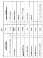
- FIG. 7 is a diagram showing a specific example of data included in the automatic driving map data and the navigation map data.
- the map data for automatic driving and the map data for navigation have a difference in quality from the content as shown in FIG. 7, for example.
- the map data for automatic driving is mainly for the control function target part, and has road data necessary for automatically driving the vehicle.
- the navigation map data mainly includes a guidance function target portion (including a narrow road), and has road data necessary for route guidance to passengers.
- the map data for automatic driving and the map data for navigation both have road data, but the contents are in accordance with the respective purposes of use, and some of the contents partially overlap each other.
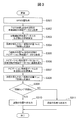
- FIG. 3 is a flowchart for explaining a series of processes of the map unit for automatic driving
- FIG. 4 is a schematic explanatory diagram for schematically explaining a series of processes of the map unit for automatic driving.
- the vehicle position is acquired from the GPS information (S301).
- the GPS position is position information of the own vehicle measured by the external positioning system, and is acquired from the own vehicle position estimation unit 201 (own vehicle position information acquisition unit).
- data on the road near the GPS position is acquired from the map data for automatic driving (S302). Specifically, a process of extracting a road existing in the vicinity of the own vehicle from the map data for automatic driving using the GPS position and acquiring the extracted road data is performed (first road data acquisition means).
- an index with each road on the automatic driving map data is calculated (S303).
- the index is a value calculated based on the difference between the position and direction of a plurality of roads on the map in the vicinity of the GPS position and the GPS position and is an index representing the likelihood of road selection.
- the values of a plurality of candidate roads are compared, and the smaller one is selected as the index.
- “Position Pa of road A” and “Indicator Ia” having the smallest indices in the vicinity of the GPS position are selected (S304).
- the index indicates the certainty that the vehicle is traveling on the road, and map matching that selects the road with the highest probability (the most likely) that the vehicle is located from each road. Used in the technology.
- the index value can be calculated by the following formula (1), for example.
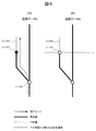
- the distance between the vehicle position of the equation (1) and the road line segment is a perpendicular distance as shown in FIG. 8, for example.
- FIG. 8 shows that the distance between the road A of the automatic driving map data and the vehicle position P is L1, and the distance between the road N of the navigation map data and the vehicle position P is L2.
- the error of the road position and direction is the standard deviation of the error inherent in the map data, and the error of the estimated position and direction is the standard deviation when the vehicle position is estimated.
- the index value is a probability index for a statistical test method called ⁇ (chi) square distribution without units, and the smaller the index value, the higher the probability of existing on the road.
- a process of calculating a first index indicating the certainty that the vehicle is traveling on a road having map data for automatic driving is performed. Specifically, an index indicating the certainty that the vehicle is traveling on all the roads extracted in S302 is calculated. Then, the most probable index among the calculated indices is set as the first index, and the first road having the first index and the own vehicle position and direction on the road of the first road are selected.
- First index calculation means In the example shown in FIG. 4A, the index Ia is the first index, and the road A having the index Ia and the position Pa and direction on the road A are selected from the map data for automatic driving.
- a road existing in the vicinity of the own vehicle is extracted from the navigation map data using the information of the position Pa selected in S304, and the extracted road data is acquired (second road data acquisition means). Then, a road in which only the navigation map data has data, that is, a road having no data in the automatic driving map data is selected from all the extracted roads (road selection means).
- “Position N of road N” and “Indicator In” having the smallest indices are selected (S308).
- an index indicating the certainty that the vehicle is traveling on all the roads selected in S306 is calculated.
- the most probable index among the calculated indices is set as the second index, and the second road having the second index and the vehicle position and the vehicle direction on the road of the second road are determined.
- Select second index calculation means.
- the index In is the second index
- the road N having the index In, the position Pn on the road N, and the vehicle direction are selected from the navigation map data.
- the selected “index Ia” and “index In” are compared (S309). As a result, if the value of “Indicator In” is smaller than “Indicator Ia”, it is likely that the index is smaller. Therefore, as shown in FIG. Pn "is output (S310). If the value of “index Ia” is smaller than “index In”, the traveling position of the vehicle is output as “road position Pa” (S311). That is, “index Ia” and “index In” are compared, and if “index In” is more likely than “index Ia”, it is determined that the vehicle is traveling on road N ( Judgment part).
- the output of S310 or S311 is transmitted from the data transmission unit 206 of the automatic driving map unit 20 to the automatic driving control ECU 30a as own vehicle position map information.
- the automatic driving control ECU 30a uses the own vehicle position map information to determine that the own vehicle is traveling on the road N of the map data for navigation and is located at the position Pn of the road N, and performs automatic driving control. Do. Therefore, it can be prevented that the vehicle is erroneously determined to be located at the position Pa of the road A and automatic control according to the attribute of the road A is performed.
- FIG. 5 shows the application status of this example.
- 5A, 5C, and 5D are maps for automatic driving, and FIG. 5B is a navigation map showing the same place.
- 5A and 5C show only the highway 51
- FIGS. 5B and 5D show both the highway 51 and the general road 61.
- FIG. 5A, 5C, and 5D are maps for automatic driving, and FIG. 5B is a navigation map showing the same place.
- 5A and 5C show only the highway 51
- FIGS. 5B and 5D show both the highway 51 and the general road 61.
- the navigation map data is supplemented and used together as shown in (B), it is assumed that the vehicle has traveled at a position 62 without a road in the automatic driving map data as shown in (D).
- the vehicle position can be correctly estimated at the position 62 outside the road of the automatic driving map data.
- the vehicle position estimation unit 201 in the automatic driving unit uses the navigation map data to grasp the correct road.
- the navigation unit 10 includes the vehicle position estimation unit 103.
- a method of using the result of this processing by the own vehicle position estimation unit 201 of the automatic driving map unit 20 is also conceivable.
- the present invention is not limited to the above-described embodiments, and various designs can be made without departing from the spirit of the present invention described in the claims. It can be changed.
- the above-described embodiment has been described in detail for easy understanding of the present invention, and is not necessarily limited to one having all the configurations described.
- a part of the configuration of an embodiment can be replaced with the configuration of another embodiment, and the configuration of another embodiment can be added to the configuration of an embodiment.
- SYMBOLS 1 ... Car-mounted processing system, 10 ... Navigation unit, 20 ... Map unit for automatic driving, 30 ... ECU group, 40 ... Relay unit, 101 ... Navigation map data transmission part, 102 ... Data recording part, 102a ... Map data storage for navigation , 201 ... own vehicle position estimation unit, 202 ... own vehicle traveling road identification unit, 203 ... output map information generation unit, 204 ... data recording unit, 204a ... automatic driving map data storage unit, 204b ... navigation map data storage , 205 ... Map data receiving unit, 206 ... Data transmitting unit
Landscapes
- Engineering & Computer Science (AREA)
- Radar, Positioning & Navigation (AREA)
- Remote Sensing (AREA)
- Physics & Mathematics (AREA)
- General Physics & Mathematics (AREA)
- Automation & Control Theory (AREA)
- Business, Economics & Management (AREA)
- Theoretical Computer Science (AREA)
- Game Theory and Decision Science (AREA)
- Evolutionary Computation (AREA)
- Artificial Intelligence (AREA)
- Medical Informatics (AREA)
- Aviation & Aerospace Engineering (AREA)
- Health & Medical Sciences (AREA)
- Mathematical Physics (AREA)
- Educational Administration (AREA)
- Educational Technology (AREA)
- Navigation (AREA)
- Traffic Control Systems (AREA)
- Instructional Devices (AREA)
- Control Of Driving Devices And Active Controlling Of Vehicle (AREA)
Abstract
本発明の課題は、乗員の運転操作の一部または全てを自動化して運転を支援する運転支援機能において、全道路で自動運転用地図が整備されていなくても適正な自車位置推定を行い、正しく自動運転の走行制御を行うことのできる道路特定装置を提供することである。本発明の道路特定装置は、道路のデータを有する自動運転用地図データと、道路のデータであって自動運転用地図データと内容が一部重複するデータを有するナビゲーション用地図データと、外部測位システムにより測位された自車の位置情報とに基づいて、自車の走行している道路を特定する。
Description
本発明は、道路特定装置および車両制御システムに係り、例えば、地図データ上における自車の走行している道路を特定し、該道路の情報を用いて、車両に備えられた各種の走行制御機能により車両に搭載された各機器を動作させ、車両の運転操作の一部または全部を自動で行うための道路特定装置および車両制御システムに関する。
近年では、車両の運転操作の一部または全部を自動的に実施して当該車両を自動的に運転する走行制御システムが開発されている。その一例として、例えば、乗員の運転負荷を低減するため、車両の外部環境を認識しながら前方を走行する先行車との車間距離を一定に保つ車間維持走行制御や自車の走行レーンを逸脱しないように走行制御する走行レーン維持制御などといった、乗員の運転操作の一部を自動化して運転を支援する運転支援制御システムが知られている。また、その発展形として、乗員が操作することなくシステムが運転操作の全部を行い、当該車両を自動的に運転する自動運転システムも検討されている。
一方、運転を支援するための情報提供装置として、ナビゲーションユニットがある。ナビゲーションユニットは、乗員に対して走行に関する案内情報の提示を行うものである。ナビゲーションユニットでは、目的地へ到達するための道路に関する情報を提供する。
先行技術として、精度が異なる複数のナビゲーション用地図を備えるものとして以下の特許文献がある。この方式では二つの縮尺の違うレーヤを使用するが、経路を重ねて表示することを主な特徴としている。
前述した近時の自動運転システムでは、車載された制御装置でいかに走行すべきかを判断する必要があるため、ナビゲーションユニットにより乗員に提示する内容(情報)とは異なり、より詳細な情報(たとえば走行レーン単位の情報などの精度・密度の高い情報)を地図情報として持っていなければならず、ナビゲーションとして利用する地図情報(ナビゲーション用地図)とは異なった自動運転用地図(走行制御用地図)が必要になる。
しかし、全ての道路に対し自動運転用地図にするにはコスト等の問題から困難を極め、全道路が整備されるまでは、前述したナビゲーション用地図と自動運転用地図を併用して利用する必要がある。
前述のように、全ての道路で自動運転用地図が整備されていない場合に、自動運転用地図が整備されている道路上ではなくその最寄りの道路を走行している時には、誤って自動運転用地図上の道路を走行していると判断してしまう恐れがある。その場合、誤判断で自動運転機能が働く条件を満たす恐れがあり、結果として実際に走行している道路と違った情報により車両が制御される恐れがある。
本発明は、前記問題に鑑みてなされたものであって、その目的とするところは、たとえば車両の運転操作の一部または全部を自動で行う自動運転システムにおいて、全道路で自動運転用地図が整備されていなくても適正な自車位置推定を行い、正しく自動運転の走行制御を行うことのできる道路特定装置及び車両制御システムを提供することにある。
上記課題を解決するため、本発明の道路特定装置では、道路のデータを有する第1の地図データと、道路のデータであって前記第1の地図データと内容が一部重複するデータを有する第2の地図データと、外部測位システムにより測位された自車の位置情報とに基づいて、前記自車の走行している道路を特定することを特徴とする。
本発明によれば、例えば自動運転用地図データなどの第1の地図データには登録されていない道路を走行しても、正しい走行中の道路を特定でき、正しい現在の位置と道路情報を利用することができ、自動運転装置による正確な自動運転を行うことができる。
本発明に関連する更なる特徴は、本明細書の記述、添付図面から明らかになるものである。また、上記した以外の、課題、構成及び効果は、以下の実施形態の説明により明らかにされる。
次に、本発明の実施の形態について説明する。なお、以下の説明において用いられる「走行」という用語には、車両が所定の速度で移動している状態だけに限られず、信号待ちや渋滞などで停止している状態も含まれる。
図1は、本発明に係る車両制御システムの実施形態1の全体構成を示すブロック図、図2は、ナビゲーションユニットおよび自動運転用地図ユニットの内部構成を示すブロック図である。
図1に示されるように、本実施形態の車載処理システム1は、車両100に搭載されるナビゲーションユニット10と、自動運転用地図ユニット20と、自動運転用制御ECU30aや外界認識用ECU30bなどの複数のECUからなるECU群30と、を備える。ナビゲーションユニット10と自動運転用地図ユニット20は、中継ユニット40を間に介在してECU群30と接続されている。ECU群30は、ナビゲーションユニット10や自動運転用地図ユニット20から入力される地図情報に基づいて車両100の走行制御を行う(走行制御装置)。
図2は、図1に示される自動運転用地図ユニットとナビゲーションユニットの内部構成を示すブロック図である。
ナビゲーションユニット10は、ナビゲーション用地図データを外部へ出力するナビゲーション地図データ送信部101と、ナビゲーション用地図データ格納部102aを持つデータ記録部102とを持つ。ナビゲーション用地図データ格納部102aには、ナビゲーション用地図データ(第2の地図データ)が格納されている。ナビゲーションユニット10は、自車位置推定部103を有していてもよい。
自動運転用地図ユニット20は、自車位置を推定する自車位置推定部201と、推定した自車位置と自動運転用地図データから自車の走行している道路を特定する自車走行道路特定部(道路特定装置)202と、自動運転用地図ユニット20の外部へ送信する地図情報を作成する出力地図情報生成部203と、自動運転用地図データ(第1の地図データ)を記憶しておく自動運転用地図データ格納部204aとナビゲーションユニット10から取得した地図データを格納しておくナビゲーション用地図データ格納部204bを持つデータ記録部204を有する。
自車位置推定部201には、図示しないGPSなどの衛星情報受信装置やジャイロや加速度センサなどのセンサ類が接続されている。これらの衛星情報受信装置やジャイロなどのセンサ類は外部測位システムを構成しており、自車を測位する。そして、自車位置推定部201は、外部測位システムにより測位された自車の位置情報を取得する。本実施例では、GNSS測量で算出されるWGS-84座標系の座標値を、自車の位置情報として取得する。
また、自動運転用地図ユニット20は、ユニット外部から地図データを受信する地図データ受信部205と、ユニット外部へ情報を送信するデータ送信部206を持ち、地図データ受信部205では、ナビゲーションユニット10からナビゲーション用の地図データを受信することができる。データ送信部206では、自車位置推定部201や自車走行道路特定部202で求めた自車の位置情報と、その自車の位置情報に基づいて出力地図情報生成部203で生成した地図情報をユニット外部へ送信することができる。
図7は、自動運転用地図データとナビゲーション用地図データが有するデータの具体例を示す図である。自動運転用地図データとナビゲーション用地図データは、例えば図7に示すようなコンテンツと質の違いを有している。
自動運転用地図データは、制御機能対象部を主とするものであり、自車を自動運転するために必要な道路のデータを有している。一方、ナビゲーション用地図データは、誘導機能対象部(細道路を含む)を主とするものであり、乗員に経路案内を行うために必要な道路のデータを有している。自動運転用地図データとナビゲーション用地図データは、いずれも道路のデータを有しているが、それぞれの使用目的に応じた内容となっており、互いに内容が一部重複している部分もある。
次に、本実施例の自車走行道路特定部202での一連の処理フローの例を図3と図4を用いて説明する。図3は、自動運転用地図ユニットの一連の処理を説明するフロー図、図4は、自動運転用地図ユニットの一連の処理を概略的に説明する概略説明図である。
まず、GPSの情報から自車位置(GPS位置)を取得する(S301)。GPS位置は、外部測位システムにより測位された自車の位置情報であり、自車位置推定部201から取得する(自車位置情報取得部)。
次に、GPS位置の近傍の道路のデータを自動運転用地図データから取得する(S302)。具体的には、GPS位置を用いて自動運転用地図データから自車の近傍に存在する道路を抽出し、抽出した道路のデータを取得する処理が行われる(第1の道路データ取得手段)。
そして、自動運転用地図データ上での各道路との指標を算出する(S303)。指標とは、GPS位置近傍にある地図上の複数の道路の位置方位とGPS位置方位との差を元に計算される値であり、道路選出の確からしさを表す指標となる。指標の算出方法の一例として候補となる複数の道路について各々の値を比較し、小さい方を指標として選出する。図4(A)の場合、前述のGPS位置近傍において指標が最も小さい「道路Aの位置Pa」と「指標Ia」を選出する(S304)。
指標は、その道路を自車が走行していることの確からしさを示すものであり、各道路の中から自車が位置している確率が最も高い(最も確からしい)道路を選出するマップマッチングの技術において用いられている。指標値は、例えば下記の式(1)により算出することができる。

式(1)の自車位置と道路線分との距離とは、例えば図8に示すように、垂線距離である。図8は、自動運転用地図データの道路Aと自車位置Pとの距離がL1であり、ナビゲーション用地図データの道路Nと自車位置Pとの距離がL2であることを示している。そして、道路位置、方位が持つ誤差とは、地図データが固有で持っている誤差の標準偏差であり、推定位置、方位の誤差とは、自車位置を推定したときの標準偏差である。指標値は、単位のないχ(カイ)2乗分布と呼ばれる統計学検定法のための確率指標となり、指標値の小さい方が、その道路上に存在する確率が高いことを示す。
ここでは、自動運転用地図データがデータを有する道路を自車が走行していることの確からしさを示す第1の指標を算出する処理が行われる。具体的には、S302で抽出した全ての道路に対してそれぞれ自車が走行していることの確からしさを示す指標を算出する。そして、算出した指標の中から最も確からしい指標を第1の指標とし、第1の指標を有する第1の道路と、第1の道路の道路上の自車位置及び自車方位と、を選出する(第1の指標算出手段)。図4(A)に示す例では、指標Iaを第1の指標とし、自動運転用地図データから指標Iaを有する道路Aと、道路Aの道路上の位置Pa及び方位を選出する。
次に、「道路Aの位置Pa」近傍の道路情報をナビゲーションユニット10のナビゲーション用地図から取得する(S305)。その結果、図4の(B)に示すように、ナビゲーション用地図データにあって、自動運転用地図データにない道路を選出する(S306)。S306で選出したナビゲーション用地図データでの各道路に対し、同様に指標を算出する(S307)。
ここでは、S304で選出された位置Paの情報を用いてナビゲーション用地図データから自車の近傍に存在する道路を抽出し、抽出した道路のデータを取得する(第2の道路データ取得手段)。そして、抽出した全ての道路の中からナビゲーション用地図データのみがデータを有している道路、すなわち、自動運転用地図データにはデータがない道路を選出する(道路選出手段)。
このとき、図6(B)に示すナビゲーション用地図においてノードYで接続されている道路を生成する際に、図6(A)に示す自動運転用地図データにおいて仮想的に設けたノードY’に接続する形でリンクS’を設ける。このようにすれば実際には接続されていない道路が近くにあった場合には間違ってその道路を掴むようなことをなくすことができる。
そして、図4の(C)に示すように、指標が最も小さい「道路Nの位置Pn」と「指標In」を選出する(S308)。ここでは、S306で選出した全ての道路に対してそれぞれ自車が走行していることの確からしさを示す指標を算出する。そして、その算出した指標の中から最も確からしい指標を第2の指標とし、第2の指標を有する第2の道路と、第2の道路の道路上の自車位置及び自車方位と、を選出する(第2の指標算出手段)。図4(C)に示す例では、指標Inを第2の指標とし、ナビゲーション用地図データから指標Inを有する道路Nと、道路Nの道路上の位置Pn及び自車方位を選出する。
次に、選出した「指標Ia」と「指標In」を比較する(S309)。その結果、もし「指標In」の値の方が「指標Ia」よりも小さければ、指標が小さい方が確からしいので、図4(D)のように、自車の走行位置を「道路の位置Pn」として出力する(S310)。もし、「指標Ia」の値の方が「指標In」よりも小さければ、自車の走行位置を「道路の位置Pa」として出力する(S311)。すなわち、「指標Ia」と「指標In」とを比較して、「指標In」の方が「指標Ia」よりも確からしい場合には、道路Nを自車が走行していると判定する(判定部)。
S310またはS311の出力は、自車位置地図情報として、自動運転用地図ユニット20のデータ送信部206から自動運転用制御ECU30aに送信される。自動運転用制御ECU30aは、自車位置地図情報を用いて、自車がナビゲーション用地図データの道路Nを走行しており、道路Nの位置Pnに位置していると判断して自動運転制御を行う。したがって、道路Aの位置Paに位置していると誤判断して、道路Aの属性に沿った自動制御がなされるのを防ぐことができる。
図5に、本実施例の適用有無の状況を示す。
図5(A)、(C)、(D)は、自動運転用地図であり、図5(B)は、同じ場所を示すナビゲーション用地図である。図5(A)、(C)には、高速道路51のみが示され、図5(B)、(D)には、高速道路51と一般道61の両方が示されている。
もし、図5(A)の自動運転用地図データしかない状態で、高速道路51を降りた場合に、(C)のように分岐路51aを過ぎて自動運転用地図データの高速道路51から外れた位置を走行することになる。したがって、従来は、先の指標情報から(C)の“×”印の位置52に誤って自車位置を推定するおそれがある。
これに対し、本実施例によれば、(B)のようにナビゲーション用地図データを補填して併用するので、(D)のように自動運転用地図データにおいて道路が無い位置62を走行したとしても、自動運転用地図データの道路外の位置62に自車位置を正しく推定することができる。
また、前述の実施例は、自動運転用ユニット内の自車位置推定部201がナビゲーション用地図データを使って正しい道路を掴むようにしたが、ナビゲーションユニット10内に自車位置推定部103がある場合は、この処理の結果を自動運転用地図ユニット20の自車位置推定部201が使うようにする方法も考えられる。
以上、本発明の実施形態について詳述したが、本発明は、前記の実施形態に限定されるものではなく、特許請求の範囲に記載された本発明の精神を逸脱しない範囲で、種々の設計変更を行うことができるものである。例えば、前記した実施の形態は本発明を分かりやすく説明するために詳細に説明したものであり、必ずしも説明した全ての構成を備えるものに限定されるものではない。また、ある実施形態の構成の一部を他の実施形態の構成に置き換えることが可能であり、また、ある実施形態の構成に他の実施形態の構成を加えることも可能である。さらに、各実施形態の構成の一部について、他の構成の追加・削除・置換をすることが可能である。
1…車載処理システム、10…ナビゲーションユニット、20…自動運転用地図ユニット、30…ECU群、40…中継ユニット、101…ナビゲーション地図データ送信部、102…データ記録部、102a…ナビゲーション用地図データ格納部、201…自車位置推定部、202…自車走行道路特定部、203…出力地図情報生成部、204…データ記録部、204a…自動運転用地図データ格納部、204b…ナビゲーション用地図データ格納部、205…地図データ受信部、206…データ送信部
Claims (6)
- 道路のデータを有する第1の地図データと、
道路のデータであって前記第1の地図データと内容が一部重複するデータを有する第2の地図データと、
外部測位システムにより測位された自車の位置情報とに基づいて、前記自車の走行している道路を特定することを特徴とする道路特定装置。 - 前記自車の近傍に前記第2の地図データのみがデータを有する道路が存在する場合、該第2の地図データのみがデータを有する道路と、前記第1の地図データがデータを有する道路のいずれを自車が走行しているのかを判定することを特徴とする請求項1に記載の道路特定装置。
- 前記第1の地図データがデータを有する道路を自車が走行していることの確からしさを示す第1の指標を算出し、
前記第2の地図データのみがデータを有する道路を自車が走行していることの確からしさを示す第2の指標を算出し、
前記第1の指標と前記第2の指標を比較して、前記第1の地図データがデータを有する道路と前記第2の地図データのみがデータを有する道路のうち、確からしさが高い方の道路を自車が走行していると判定する
ことを特徴とする請求項2に記載の道路特定装置。 - 外部測位システムにより測位された自車の位置情報を取得する自車位置情報取得部と、 該自車の位置情報を用いて前記第1の地図データから自車の近傍に存在する道路を抽出し、該抽出した道路のデータを取得する第1の道路データ取得手段と、
該抽出した全ての道路に対してそれぞれ自車が走行していることの確からしさを示す指標を算出し、該算出した指標の中から最も確からしい指標を第1の指標とし、該第1の指標を有する第1の道路と、該第1の道路の道路上の自車位置と、を選出する第1の指標算出手段と、
該選出された道路上の自車位置の情報を用いて前記第2の地図データから自車の近傍に存在する道路を抽出し、該抽出した道路のデータを取得する第2の道路データ取得手段と、
該抽出した全ての道路の中から前記第2の地図データのみがデータを有しており前記第1の地図データにはデータがない道路を選出する道路選出手段と、
該選出した全ての道路に対してそれぞれ自車が走行していることの確からしさを示す指標を算出し、該算出した指標の中から最も確からしい指標を第2の指標とし、該第2の指標を有する第2の道路と、該第2の道路の道路上の自車位置と、を選出する第2の指標算出手段と、
前記第1の指標と前記第2の指標とを比較して、前記第2の指標の方が前記第1の指標よりも確からしい場合には、前記第2の道路を自車が走行していると判定する判定部と、
を有することを特徴とする請求項3に記載の道路特定装置。 - 前記第1の地図データは、自動運転用地図データであり、
前記第2の地図データは、ナビゲーション用地図データであることを特徴とする請求項1から請求項4のいずれか一項に記載の道路特定装置。 - 請求項1から請求項5のいずれか一項に記載の道路特定装置と、
該道路特定装置によって特定された自車が走行している道路のデータに基づいて自車の走行制御を行う走行制御装置と、
を有することを特徴とする車両制御システム。
Priority Applications (3)
| Application Number | Priority Date | Filing Date | Title |
|---|---|---|---|
| CN201780066994.9A CN109923375B (zh) | 2016-12-09 | 2017-11-30 | 道路确定装置和车辆控制系统 |
| US16/346,156 US11168991B2 (en) | 2016-12-09 | 2017-11-30 | Road identifying device, and vehicle control system |
| EP17877844.5A EP3553471A4 (en) | 2016-12-09 | 2017-11-30 | ROUTE IDENTIFICATION DEVICE AND VEHICLE CONTROL SYSTEM |
Applications Claiming Priority (2)
| Application Number | Priority Date | Filing Date | Title |
|---|---|---|---|
| JP2016-239191 | 2016-12-09 | ||
| JP2016239191A JP6609540B2 (ja) | 2016-12-09 | 2016-12-09 | 道路特定装置及び車両制御システム |
Publications (1)
| Publication Number | Publication Date |
|---|---|
| WO2018105469A1 true WO2018105469A1 (ja) | 2018-06-14 |
Family
ID=62491021
Family Applications (1)
| Application Number | Title | Priority Date | Filing Date |
|---|---|---|---|
| PCT/JP2017/042945 Ceased WO2018105469A1 (ja) | 2016-12-09 | 2017-11-30 | 道路特定装置及び車両制御システム |
Country Status (5)
| Country | Link |
|---|---|
| US (1) | US11168991B2 (ja) |
| EP (1) | EP3553471A4 (ja) |
| JP (1) | JP6609540B2 (ja) |
| CN (1) | CN109923375B (ja) |
| WO (1) | WO2018105469A1 (ja) |
Cited By (1)
| Publication number | Priority date | Publication date | Assignee | Title |
|---|---|---|---|---|
| CN112683282A (zh) * | 2020-12-14 | 2021-04-20 | 上海市政工程设计研究总院(集团)有限公司 | 射频识别和地图法融合的机动车动态定位与导航系统 |
Families Citing this family (7)
| Publication number | Priority date | Publication date | Assignee | Title |
|---|---|---|---|---|
| JP6821527B2 (ja) * | 2017-08-22 | 2021-01-27 | アイシン・エィ・ダブリュ株式会社 | 運転支援システム、経路案内システム、運転支援方法および運転支援プログラム |
| US11862012B2 (en) | 2018-11-29 | 2024-01-02 | Hitachi Astemo, Ltd. | Vehicle control system and server |
| JP7504131B2 (ja) * | 2020-01-09 | 2024-06-21 | 三菱電機株式会社 | 運転支援装置及び運転支援方法 |
| JP7365939B2 (ja) * | 2020-03-04 | 2023-10-20 | 日立Astemo株式会社 | 電子制御装置、制御方法及び自動運転システム |
| JP7287353B2 (ja) | 2020-06-11 | 2023-06-06 | トヨタ自動車株式会社 | 位置推定装置及び位置推定用コンピュータプログラム |
| CN113873426B (zh) * | 2020-06-30 | 2025-01-24 | 罗伯特·博世有限公司 | 用于决策车辆的地理围栏事件的系统、控制单元和方法 |
| JP7297169B2 (ja) | 2020-10-23 | 2023-06-23 | 三菱電機株式会社 | 地図データ管理装置および地図データ管理方法 |
Citations (6)
| Publication number | Priority date | Publication date | Assignee | Title |
|---|---|---|---|---|
| JPH09197962A (ja) * | 1996-01-11 | 1997-07-31 | Toppan Printing Co Ltd | 高速道路専用地図及び高速道路専用地図帳 |
| JPH10122887A (ja) | 1996-10-22 | 1998-05-15 | Zanavy Informatics:Kk | ナビゲーション装置 |
| JPH11328597A (ja) * | 1998-05-15 | 1999-11-30 | Fujitsu Ten Ltd | 車両運転制御装置 |
| JP2003315055A (ja) * | 2002-04-25 | 2003-11-06 | Aisin Aw Co Ltd | ナビゲーション装置 |
| JP2009156940A (ja) * | 2007-12-25 | 2009-07-16 | Aisin Aw Co Ltd | 経路探索方法 |
| JP2016176698A (ja) * | 2015-03-18 | 2016-10-06 | アイシン・エィ・ダブリュ株式会社 | ナビゲーション装置、ナビゲーションプログラム、及びナビゲーション方法 |
Family Cites Families (11)
| Publication number | Priority date | Publication date | Assignee | Title |
|---|---|---|---|---|
| JPH1183511A (ja) * | 1997-09-02 | 1999-03-26 | Denso Corp | 車両用走行経路案内装置及び記憶媒体 |
| US6937936B2 (en) | 2002-04-25 | 2005-08-30 | Aisin Aw Co., Ltd. | Navigation system |
| JP2004354395A (ja) | 2004-09-09 | 2004-12-16 | Matsushita Electric Ind Co Ltd | マップマッチング方法と装置 |
| JP4797901B2 (ja) * | 2006-09-12 | 2011-10-19 | 株式会社デンソー | 現在位置表示装置、ナビゲーション装置、プログラム |
| JP2011158393A (ja) * | 2010-02-02 | 2011-08-18 | Alpine Electronics Inc | ナビゲーション装置および誘導経路探索方法 |
| DE102010029138A1 (de) * | 2010-05-19 | 2011-11-24 | Bayerische Motoren Werke Aktiengesellschaft | Navigationsverfahren und Kraftfahrzeugnavigationssystem |
| JP5845016B2 (ja) * | 2011-07-27 | 2016-01-20 | 株式会社デンソー | 地図差分データ作成装置及び地図差分データ作成方法 |
| JP6427908B2 (ja) * | 2014-03-24 | 2018-11-28 | アイシン・エィ・ダブリュ株式会社 | 地図情報生成システム、方法およびプログラム |
| JP6398377B2 (ja) * | 2014-06-30 | 2018-10-03 | カシオ計算機株式会社 | 情報処理装置、情報処理方法及びプログラム |
| JP6386300B2 (ja) | 2014-08-28 | 2018-09-05 | 株式会社ゼンリン | 車両位置特定装置および運転支援装置 |
| CN111380545B (zh) * | 2015-02-10 | 2024-11-12 | 御眼视觉技术有限公司 | 用于自主车辆导航的方法、服务器、自主车辆以及介质 |
-
2016
- 2016-12-09 JP JP2016239191A patent/JP6609540B2/ja active Active
-
2017
- 2017-11-30 EP EP17877844.5A patent/EP3553471A4/en not_active Withdrawn
- 2017-11-30 US US16/346,156 patent/US11168991B2/en active Active
- 2017-11-30 WO PCT/JP2017/042945 patent/WO2018105469A1/ja not_active Ceased
- 2017-11-30 CN CN201780066994.9A patent/CN109923375B/zh active Active
Patent Citations (6)
| Publication number | Priority date | Publication date | Assignee | Title |
|---|---|---|---|---|
| JPH09197962A (ja) * | 1996-01-11 | 1997-07-31 | Toppan Printing Co Ltd | 高速道路専用地図及び高速道路専用地図帳 |
| JPH10122887A (ja) | 1996-10-22 | 1998-05-15 | Zanavy Informatics:Kk | ナビゲーション装置 |
| JPH11328597A (ja) * | 1998-05-15 | 1999-11-30 | Fujitsu Ten Ltd | 車両運転制御装置 |
| JP2003315055A (ja) * | 2002-04-25 | 2003-11-06 | Aisin Aw Co Ltd | ナビゲーション装置 |
| JP2009156940A (ja) * | 2007-12-25 | 2009-07-16 | Aisin Aw Co Ltd | 経路探索方法 |
| JP2016176698A (ja) * | 2015-03-18 | 2016-10-06 | アイシン・エィ・ダブリュ株式会社 | ナビゲーション装置、ナビゲーションプログラム、及びナビゲーション方法 |
Non-Patent Citations (1)
| Title |
|---|
| See also references of EP3553471A4 |
Cited By (1)
| Publication number | Priority date | Publication date | Assignee | Title |
|---|---|---|---|---|
| CN112683282A (zh) * | 2020-12-14 | 2021-04-20 | 上海市政工程设计研究总院(集团)有限公司 | 射频识别和地图法融合的机动车动态定位与导航系统 |
Also Published As
| Publication number | Publication date |
|---|---|
| EP3553471A4 (en) | 2020-08-12 |
| JP2018096743A (ja) | 2018-06-21 |
| JP6609540B2 (ja) | 2019-11-20 |
| EP3553471A1 (en) | 2019-10-16 |
| US11168991B2 (en) | 2021-11-09 |
| CN109923375A (zh) | 2019-06-21 |
| CN109923375B (zh) | 2023-04-25 |
| US20200056894A1 (en) | 2020-02-20 |
Similar Documents
| Publication | Publication Date | Title |
|---|---|---|
| JP6609540B2 (ja) | 道路特定装置及び車両制御システム | |
| KR101214474B1 (ko) | 네비게이션 장치 및 이를 이용한 주행 경로 정보 제공 방법, 자동 주행 시스템 및 그 방법 | |
| US9228845B2 (en) | Navigation device, navigation method, and program | |
| CN114144637B (zh) | 从用户行为补充电子地图数据 | |
| CN110546696A (zh) | 用于自主车辆的用于自动生成和更新数据集的方法 | |
| CN105973248A (zh) | 导航系统 | |
| US20130110394A1 (en) | Navigation system | |
| JP5990018B2 (ja) | ナビゲーション装置、情報提供方法及びプログラム | |
| US20220316913A1 (en) | Map information assessment device, storage medium storing computer program for map information assessment, and map information assessment method | |
| JP2009036651A (ja) | ナビゲーション装置、ナビゲーション方法及びナビゲーションプログラム | |
| US20230049449A1 (en) | Map matching apparatus and map matching method | |
| JP4554418B2 (ja) | 車載用ナビゲーション装置 | |
| CN109313034B (zh) | 行驶控制系统 | |
| US12607466B2 (en) | System and method for map matching GNSS positions of a vehicle | |
| JP2008197703A (ja) | 車両の情報提供装置 | |
| JP4571887B2 (ja) | ナビゲーションシステム、マッチング方法、経路探索サーバおよびナビゲーション端末装置 | |
| JP5276922B2 (ja) | 現在位置算出装置 | |
| JP4369900B2 (ja) | マッチング用ネットワークデータおよびマッチング用ネットワークデータの作成方法、ならびに、マッチング用ネットワークデータを有するナビゲーションシステム、経路探索サーバおよびナビゲーション端末装置 | |
| CN108630002A (zh) | 用于确定车辆的至少一个最可能路径的方法和装置 | |
| JP6211316B2 (ja) | 運転支援装置 | |
| JP2011145090A (ja) | 車両のナビゲーション装置 | |
| JP2011196687A (ja) | 経路案内装置 | |
| JP6758760B2 (ja) | ナビゲーション装置 | |
| US12281903B2 (en) | Vehicle route guidance device based on predicting deviation from route | |
| CN114550481B (zh) | 信息处理装置、信息处理系统、信息处理方法以及存储介质 |
Legal Events
| Date | Code | Title | Description |
|---|---|---|---|
| 121 | Ep: the epo has been informed by wipo that ep was designated in this application |
Ref document number: 17877844 Country of ref document: EP Kind code of ref document: A1 |
|
| NENP | Non-entry into the national phase |
Ref country code: DE |
|
| ENP | Entry into the national phase |
Ref document number: 2017877844 Country of ref document: EP Effective date: 20190709 |
|
| WWW | Wipo information: withdrawn in national office |
Ref document number: 2017877844 Country of ref document: EP |