CN102722909B - Assembly line topology network dynamic simulation method based on adaptive-dimensional DEM (dynamic effect model) - Google Patents
Assembly line topology network dynamic simulation method based on adaptive-dimensional DEM (dynamic effect model) Download PDFInfo
- Publication number
- CN102722909B CN102722909B CN201210167885.5A CN201210167885A CN102722909B CN 102722909 B CN102722909 B CN 102722909B CN 201210167885 A CN201210167885 A CN 201210167885A CN 102722909 B CN102722909 B CN 102722909B
- Authority
- CN
- China
- Prior art keywords
- water flow
- scale
- hydrological
- dem
- topology network
- Prior art date
- Legal status (The legal status is an assumption and is not a legal conclusion. Google has not performed a legal analysis and makes no representation as to the accuracy of the status listed.)
- Expired - Fee Related
Links
- 238000000034 method Methods 0.000 title claims abstract description 60
- 238000005094 computer simulation Methods 0.000 title claims abstract description 33
- 230000000694 effects Effects 0.000 title description 2
- XLYOFNOQVPJJNP-UHFFFAOYSA-N water Substances O XLYOFNOQVPJJNP-UHFFFAOYSA-N 0.000 claims abstract description 75
- 239000002352 surface water Substances 0.000 claims abstract description 28
- 230000003044 adaptive effect Effects 0.000 claims abstract description 14
- 230000008569 process Effects 0.000 claims description 30
- 230000001788 irregular Effects 0.000 claims description 15
- 238000005070 sampling Methods 0.000 claims description 14
- 230000007613 environmental effect Effects 0.000 claims description 12
- 230000005484 gravity Effects 0.000 claims description 10
- 238000009828 non-uniform distribution Methods 0.000 claims description 3
- 238000009827 uniform distribution Methods 0.000 claims description 3
- ATJFFYVFTNAWJD-UHFFFAOYSA-N Tin Chemical compound [Sn] ATJFFYVFTNAWJD-UHFFFAOYSA-N 0.000 abstract description 34
- 239000000284 extract Substances 0.000 abstract description 3
- 238000011439 discrete element method Methods 0.000 description 46
- 238000004088 simulation Methods 0.000 description 30
- 238000004364 calculation method Methods 0.000 description 14
- 238000004422 calculation algorithm Methods 0.000 description 11
- 238000004458 analytical method Methods 0.000 description 9
- 238000011160 research Methods 0.000 description 9
- 238000000605 extraction Methods 0.000 description 5
- 238000011161 development Methods 0.000 description 4
- 238000001704 evaporation Methods 0.000 description 4
- 230000008020 evaporation Effects 0.000 description 4
- 238000013277 forecasting method Methods 0.000 description 4
- 238000013507 mapping Methods 0.000 description 4
- 239000002689 soil Substances 0.000 description 4
- 230000002123 temporal effect Effects 0.000 description 4
- 238000012360 testing method Methods 0.000 description 4
- 230000015572 biosynthetic process Effects 0.000 description 3
- 238000013461 design Methods 0.000 description 3
- 238000011156 evaluation Methods 0.000 description 3
- 238000001764 infiltration Methods 0.000 description 3
- 230000008595 infiltration Effects 0.000 description 3
- 150000001875 compounds Chemical class 0.000 description 2
- 230000003628 erosive effect Effects 0.000 description 2
- 238000007726 management method Methods 0.000 description 2
- 238000004519 manufacturing process Methods 0.000 description 2
- 238000005259 measurement Methods 0.000 description 2
- 230000007246 mechanism Effects 0.000 description 2
- 238000003860 storage Methods 0.000 description 2
- 238000003786 synthesis reaction Methods 0.000 description 2
- 238000011144 upstream manufacturing Methods 0.000 description 2
- CZIANYBTJZHSQL-XXFZXMJFSA-N 4-azido-n-hexadecyl-2-hydroxy-3-iodanylbenzamide Chemical compound CCCCCCCCCCCCCCCCNC(=O)C1=CC=C(N=[N+]=[N-])C([125I])=C1O CZIANYBTJZHSQL-XXFZXMJFSA-N 0.000 description 1
- 208000014669 Hemophagocytic syndrome associated with an infection Diseases 0.000 description 1
- 230000002411 adverse Effects 0.000 description 1
- 238000013459 approach Methods 0.000 description 1
- 230000008859 change Effects 0.000 description 1
- 230000000052 comparative effect Effects 0.000 description 1
- 238000011157 data evaluation Methods 0.000 description 1
- 238000013499 data model Methods 0.000 description 1
- 238000013500 data storage Methods 0.000 description 1
- 230000008021 deposition Effects 0.000 description 1
- 238000001514 detection method Methods 0.000 description 1
- 238000010586 diagram Methods 0.000 description 1
- 238000009826 distribution Methods 0.000 description 1
- 230000007774 longterm Effects 0.000 description 1
- 238000012986 modification Methods 0.000 description 1
- 230000004048 modification Effects 0.000 description 1
- 238000012544 monitoring process Methods 0.000 description 1
- 238000013439 planning Methods 0.000 description 1
- 230000004044 response Effects 0.000 description 1
- 238000000926 separation method Methods 0.000 description 1
- 238000004162 soil erosion Methods 0.000 description 1
- 238000001308 synthesis method Methods 0.000 description 1
- 230000009466 transformation Effects 0.000 description 1
- 238000003911 water pollution Methods 0.000 description 1
Images


Landscapes
- Management, Administration, Business Operations System, And Electronic Commerce (AREA)
Abstract
本发明提出了一种基于自适应尺度DEM的流水线拓扑网络动态模拟方法,即充分利用日益增长的高精度DEM数据,提取地形、水文特征,并给特征赋予尺度属性,从而构建基于河流网约束TIN的自适应尺度DEM数据库。在此基础上,计算TIN中每一个三角形的水流方向,构建从任意位置到流域出口的水流线路,从而将三维的地形表达简化为一维的拓扑流水线结构,实现嵌套式的多尺度多层级拓扑结构,利用经典的水文公式计算相关水文参量,实现从广域到局部范围的地表水流动态模拟多尺度应用。
The present invention proposes a dynamic simulation method of pipeline topology network based on self-adaptive scale DEM, that is to make full use of the increasing high-precision DEM data, extract terrain and hydrological features, and assign scale attributes to the features, thereby constructing a TIN based on river network constraints The Adaptive Scale DEM Database. On this basis, the water flow direction of each triangle in the TIN is calculated, and the water flow line from any position to the outlet of the watershed is constructed, thereby simplifying the three-dimensional terrain expression into a one-dimensional topological pipeline structure, and realizing nested multi-scale and multi-level Topological structure, using classical hydrological formulas to calculate relevant hydrological parameters, and realize multi-scale applications of dynamic simulation of surface water flow from wide area to local area.
Description
技术领域 technical field
本发明属于数字地形分析领域,特别涉及基于自适应尺度DEM的流水线拓扑网络动态模拟方法。The invention belongs to the field of digital terrain analysis, in particular to a dynamic simulation method of pipeline topology network based on self-adaptive scale DEM.
背景技术 Background technique
地学过程的动态模拟与预测是当前地理学、环境科学、信息科学等多学科领域所共同关注的一个研究热点问题。水文模型作为地学过程动态模拟的一个典型应用长期受到众多专家、学者的关注。例如,通过地表水过程的动态模拟,可在降雨径流形成原理和洪水波运动规律的基础上,对洪水灾情进行预测,以辅助防洪决策支持;对突发性水污染事故造成的污染情况进行模拟,以便能及时确定受影响的范围和对象,采取适当的措施控制其不利影响。The dynamic simulation and prediction of geoscience processes is a research hotspot in the fields of geography, environmental science, information science and so on. As a typical application of dynamic simulation of geoscience process, hydrological model has attracted the attention of many experts and scholars for a long time. For example, through the dynamic simulation of the surface water process, the flood disaster situation can be predicted on the basis of the rainfall runoff formation principle and the flood wave movement law, so as to assist in flood control decision support; the pollution caused by sudden water pollution accidents can be simulated , so that the affected scope and objects can be determined in time, and appropriate measures can be taken to control its adverse effects.
时空动态模拟中的尺度问题涉及到两个方面:空间尺度和时间尺度。很多与水文相关的地形参数都是连续变化的,数字化过程中必须对地形进行简化,空间尺度(空间分辨率)越高,数字地形越能表述真实的水文参数,但是空间分辨率增加,数据存储与处理的数量越大。同样,在时间尺度中,水文参数的记录和计算时间间隔越短,越能真实描述水文过程,但使得存储和计算量极大地增加。另一方面,不同的水文过程可能作用于不同的空间和时间尺度,因此准确的描述这些水文过程要求水文模型同时兼容多个时间尺度。如何根据水文过程自适应地选择所需尺度是亟待解决的关键问题。The scale problem in spatiotemporal dynamic simulation involves two aspects: spatial scale and time scale. Many terrain parameters related to hydrology are continuously changing, and the terrain must be simplified during the digitization process. The higher the spatial scale (spatial resolution), the better the digital terrain can express the real hydrological parameters, but the spatial resolution increases, and the data storage And the larger the number of handles. Similarly, in the time scale, the shorter the time interval between the recording and calculation of hydrological parameters, the more realistic the description of the hydrological process, but it will greatly increase the amount of storage and calculation. On the other hand, different hydrological processes may act on different spatial and temporal scales, so accurately describing these hydrological processes requires hydrological models to be compatible with multiple time scales at the same time. How to adaptively select the required scale according to the hydrological process is a key problem to be solved urgently.
水文模型在数十年的研究过程中,经历了从传统的集总式模型,到半分布式模型,再到空间分布式模型的发展历程(Saint-Venant,1871;Abbott et al.,1986;Turcotte et al.,2001)。当前的水文模型需要充分考虑环境因素和水文过程的时空变化分布,而数字地形建模方法有效地提供了地理空间信息的管理及分析方法,使得在一定条件下基于物理原理来预测径流的时空模式成为可能。During decades of research, the hydrological model has experienced the development process from the traditional lumped model, to the semi-distributed model, and then to the spatially distributed model (Saint-Venant, 1871; Abbott et al., 1986; Turcotte et al., 2001). The current hydrological model needs to fully consider the environmental factors and the spatial and temporal distribution of hydrological processes, while the digital terrain modeling method effectively provides management and analysis methods for geospatial information, making it possible to predict the temporal and spatial patterns of runoff based on physical principles under certain conditions become possible.
水文模型中通常采用的地形表面描述方法是规则格网DEM(李志林等,2000;周启鸣等,2006)。DEM即数字高程模型。随着早期GIS(地理信息系统)的出现,基于规则格网DEM的水文模型就得以发展,并在分布式水文模型中得到了广泛应用。Beven et al.(1979)提出了一种基于地形的水文模型(TOPMODEL),为了计算产汇流,该模型基于DEM推求地形参数来反映地表及浅层地下层的水文特征。但TOPMODEL并未考虑降雨和蒸发等水文物理过程,因而只是部分模拟了水文过程。Beven et al.(1980)等联合研制并改进的SHE模型(SystemHydrologic European)是一个典型的分布式水文模型,其流域被划分为三维(垂直多层)规则网格,以便结合模型参数和降雨输入来模拟水文过程。Arnold(1994)为USDA开发了SWAT模型(Soil and Water Assessment Tool)。SWAT模型属于半分布式水文模型,它利用栅格DEM以融合GIS和RS(遥感)提供的空间信息划分水文特征区以减少计算量,从而模拟复杂大流域中的水文物理过程。The terrain surface description method usually used in hydrological models is regular grid DEM (Li Zhilin et al., 2000; Zhou Qiming et al., 2006). DEM stands for Digital Elevation Model. With the emergence of early GIS (Geographic Information System), hydrological models based on regular grid DEM have been developed and widely used in distributed hydrological models. Beven et al. (1979) proposed a terrain-based hydrological model (TOPMODEL). In order to calculate the production and confluence, the model calculated topographic parameters based on DEM to reflect the hydrological characteristics of the surface and shallow underground layers. However, TOPMODEL does not consider hydrological physical processes such as rainfall and evaporation, so it only partially simulates hydrological processes. The SHE model (System Hydrologic European) jointly developed and improved by Beven et al. (1980) is a typical distributed hydrological model, and its watershed is divided into three-dimensional (vertical multi-layer) regular grids to combine model parameters and rainfall input to simulate hydrological processes. Arnold (1994) developed the SWAT model (Soil and Water Assessment Tool) for USDA. The SWAT model belongs to the semi-distributed hydrological model, which uses grid DEM to integrate the spatial information provided by GIS and RS (remote sensing) to divide the hydrological feature area to reduce the amount of calculation, thereby simulating the hydrophysical process in complex large watersheds.
由于规则格网DEM本身就是一个对真实世界连续表面使用规则空间采样的近似描述,其精度被量测误差、采样误差、格网分辨率等因素制约,难以充分准确表达变化多样的地形特征。虽然尺度越精细,所描述的时空过程越接近真实数据,却也极大增加了存储量和计算量。为使所选择的DEM数据尺度能够符合水文模拟所需尺度,通常采用DEM数据综合方法(费立凡等,2006,胡鹏等,2009)。Zhang and Montgomery(1994)采用不同栅格分辨率(2-90m)检测了栅格大小对地形表达和水文模拟的影响,结果显示DEM栅格分辨率对地形参数和水位计算有很大影响。Zhou and Liu(2004)研究了DEM栅格分辨率对多种坡度和坡向算法的影响,并推断DEM地形参数的不确定性与栅格数据结构紧密相关。Since the regular grid DEM itself is an approximate description of the continuous surface in the real world using regular space sampling, its accuracy is restricted by factors such as measurement error, sampling error, and grid resolution, and it is difficult to fully and accurately express various terrain features. Although the finer the scale, the closer the described spatiotemporal process is to real data, but it also greatly increases the amount of storage and calculation. In order to make the selected DEM data scale meet the scale required for hydrological simulation, the DEM data synthesis method is usually adopted (Fei Lifan et al., 2006, Hu Peng et al., 2009). Zhang and Montgomery (1994) used different grid resolutions (2-90m) to test the influence of grid size on terrain representation and hydrological simulation. The results showed that DEM grid resolution has a great influence on terrain parameters and water level calculation. Zhou and Liu (2004) studied the influence of DEM raster resolution on various slope and aspect algorithms, and concluded that the uncertainty of DEM terrain parameters is closely related to the raster data structure.
另一种方法是在水文应用中采用不规则三角网(TIN)模型。TIN具有一定的矢量数据特征,能够有效地表达任何大小、形状和角度的点、线和面,而且可以方便地嵌入特征点(“转折点”等)和特征线(流水线、山脊线等),从而有效地表达地形变化。Vivoni,et al.(2005)在TIN模型中嵌入河流线、河流边界以及河漫滩等水文特征构建适应于水文应用的数字地表模型。Zhou and Chen(2011)提出了一种地形混合点提取算法(Compound Point Extraction,CPE)来构建受流水线约束的TIN结构,基于受约束的TIN,可从任意起点沿着TIN表面上相邻三角形的最大坡降方向描绘水流路径。Another approach is to use triangulated irregular network (TIN) models in hydrological applications. TIN has certain vector data characteristics, can effectively express points, lines and surfaces of any size, shape and angle, and can easily embed feature points ("turning points", etc.) and feature lines (pipeline, ridge line, etc.), so that Effectively express terrain changes. Vivoni, et al. (2005) embedded hydrological characteristics such as river lines, river boundaries, and floodplains in the TIN model to construct a digital surface model suitable for hydrological applications. Zhou and Chen (2011) proposed a terrain compound point extraction algorithm (Compound Point Extraction, CPE) to construct the TIN structure subject to pipeline constraints. The direction of maximum slope delineates the flow path.
相对于基于规则格网的DEM的水文模型,基于TIN的地形表达的水文模型在某些方面有一些天然优势。然而由于TIN数据结构的不规则性,对于空间水文过程的模拟以及相关算法提出了很大的挑战。基于TIN的综合方法在水文应用中主要利用特征点(如拐点)和特征线(如流域线)构建TIN表达不同尺度下的地形表面(Heller,1990)。Kidner et al.(2000)对多尺度数据模型提出了一种无拓扑的TIN结构,只存储特征点和线(如流域线、山脊线),并构建了便于多尺度查询的层次TIN模型。Danovaro et al.(2006)提出了一种多分辨率表面网络(MSN),采用特征点(极小值点、极大值点和鞍点)和特征线构建TIN来描述各种分辨率的地表。Compared with the hydrological model based on regular grid DEM, the hydrological model based on TIN terrain representation has some natural advantages in some aspects. However, due to the irregularity of the TIN data structure, it poses great challenges to the simulation of spatial hydrological processes and related algorithms. The comprehensive method based on TIN mainly uses characteristic points (such as inflection points) and characteristic lines (such as watershed lines) to construct TINs to express topographic surfaces at different scales in hydrological applications (Heller, 1990). Kidner et al. (2000) proposed a topology-free TIN structure for multi-scale data models, which only store feature points and lines (such as watershed lines and ridge lines), and constructed a hierarchical TIN model that facilitates multi-scale query. Danovaro et al. (2006) proposed a multi-resolution surface network (MSN), using feature points (minimum point, maximum point and saddle point) and feature lines to construct TIN to describe the surface of various resolutions.
无论是基于格网DEM还是基于TIN的地表模型表达仅仅描述了地形表面,还不能表现出地表水流的动态特征。由于地表水是自然地理环境中最活跃的因素,因此对地表水过程的动态模拟也是地学过程模拟中最重要的组成部分。地表水动态模拟与预测的关键问题是如何确定流量和流速之间的关系(Djokic and Maidment,1993)。Whether it is based on grid DEM or TIN, the expression of surface model only describes the terrain surface, and cannot show the dynamic characteristics of surface water flow. Since surface water is the most active factor in the natural geographical environment, the dynamic simulation of surface water process is also the most important part of geoscience process simulation. The key issue in the simulation and prediction of surface water dynamics is how to determine the relationship between flow and velocity (Djokic and Maidment, 1993).
早期对地表水动态模拟采用经验公式进行推算(Dietrich et al,1993)。随着数字地形模型和数字地形分析研究的进展,使得采用物理模型来预测一定环境条件下的径流和土壤侵蚀成为可能(Beven and Moore,1994)。Bates and Roo(2000)提出了针对河道径流的一维运动波近似法以及洪泛区径流的二维扩散波表示法。Tucker et al.(2001)提出了CHILD模型(Channel-Hillslope Integrated Landscape Development),它基于TIN模型模拟出由侵蚀与沉积作用导致的地形变化。Vivoni et al.(2005)开发出tRIBS模型(TIN-based Real-time IntegratedBasin Simulator)以预测降雨后地表和地下的水文响应。Early simulations of surface water dynamics used empirical formulas to calculate (Dietrich et al, 1993). With the development of digital terrain model and digital terrain analysis research, it is possible to use physical models to predict runoff and soil erosion under certain environmental conditions (Beven and Moore, 1994). Bates and Roo (2000) proposed a one-dimensional kinematic wave approximation for river runoff and a two-dimensional diffuse wave representation for floodplain runoff. Tucker et al. (2001) proposed the CHILD model (Channel-Hillslope Integrated Landscape Development), which simulates terrain changes caused by erosion and deposition based on the TIN model. Vivoni et al. (2005) developed the tRIBS model (TIN-based Real-time Integrated Basin Simulator) to predict the hydrological response of the surface and subsurface after rainfall.
尽管科学家进行多年的努力,当前实际应用的水文模型大多都是非分布式或者半分布式水文模型,地理信息系统仅仅用来计算流域水文参数。工程上实际应用的水文模型主要是采用传统水文模型捆绑到地理信息系统上的非分布式水文模型,例如TR20,HEC-1,SWAT等,分布式水文模型基本上仅用于实验室研究小范围水文动态。这是因为分布式水文模型至今无法妥善解决时间与空间尺度的分辨率与超大计算量之间的矛盾。Despite the efforts of scientists for many years, most of the currently applied hydrological models are non-distributed or semi-distributed hydrological models, and GIS is only used to calculate the hydrological parameters of the watershed. The hydrological models actually used in engineering are mainly non-distributed hydrological models bound to geographic information systems using traditional hydrological models, such as TR20, HEC-1, SWAT, etc. Distributed hydrological models are basically only used for small-scale laboratory research Hydrological dynamics. This is because the distributed hydrological model has not been able to properly resolve the contradiction between the resolution of time and space scales and the huge amount of calculation.
现有的发明大多采用基于栅格的分布式水文模型,进行单一尺度的水文模拟和洪水预报,与之相关的有:Most of the existing inventions use grid-based distributed hydrological models to perform single-scale hydrological simulations and flood forecasts, and are related to:
南京大学的张万昌等(2011,参见背景文献23)提出了一种以栅格为模拟单元的分布式水文模型设计方法。它将分布式参数矢量数据转换为栅格数据,建立栅格通用产流类型,通过产流和汇流过程设计,进行不同条件下模型的产流、汇流过程演算。最终实现干旱区和湿润区的流域水文过程模拟,以及流域的短期洪水预报和长期降雨~径流过程模拟。Zhang Wanchang et al. (2011, see background document 23) of Nanjing University proposed a distributed hydrological model design method using grid as the simulation unit. It converts the distributed parameter vector data into raster data, establishes the common runoff type of the grid, and performs the calculation of the runoff and confluence process of the model under different conditions through the design of the runoff and confluence process. Finally, the hydrological process simulation of the watershed in the arid and humid areas, as well as the short-term flood forecast and the long-term rainfall-runoff process simulation of the watershed will be realized.
浙江大学的冉启华等(2011,参见背景文献24)提出了一种基于降雨-径流-洪水演进计算的洪水预报方法。它根据分布式水文模型和水动力模型的规范和要求进行水文数据集成,并利用模型进行洪水演进过程;比较计算流域内各河道关键节点的水位预报数据以及警戒水位数据,并进行结果发布。最终能够方便的根据实测雨、水情进行各点的洪水预报。Ran Qihua et al. (2011, see Background Document 24) from Zhejiang University proposed a flood forecasting method based on rainfall-runoff-flood evolution calculations. It integrates hydrological data according to the specifications and requirements of the distributed hydrological model and hydrodynamic model, and uses the model to carry out the flood evolution process; compares and calculates the water level forecast data and warning water level data of key nodes in the river basin, and releases the results. In the end, the flood forecast of each point can be conveniently carried out according to the measured rain and water regime.
国网电力科学研究院的李春红等(2010,参见背景文献25)提出了一种不同机制水文模型组合的水文预报方法。根据流域特性,配置符合流域特性的3种或3种以上中期水文预报模型,并采用水文历史数据,针对每一种水文预报模型率定出综合精度最高的模型参数。在每个预报时刻,配置不同的预报组合方案,并依据优选参数进行前期试预报计算;自动评定各组合方案的试预报计算结果,获得当前最优的组合方式,最终应用于当前水文预报。Li Chunhong et al. (2010, see Background Document 25) from the State Grid Electric Power Research Institute proposed a hydrological forecasting method combining hydrological models with different mechanisms. According to the characteristics of the watershed, configure three or more medium-term hydrological forecast models that conform to the characteristics of the watershed, and use historical hydrological data to determine the model parameters with the highest comprehensive accuracy for each hydrological forecast model rate. At each forecast moment, configure different forecast combination schemes, and perform pre-test forecast calculations based on optimal parameters; automatically evaluate the test forecast calculation results of each combination scheme, obtain the current optimal combination method, and finally apply it to the current hydrological forecast.
以上发明并未考虑到时空尺度问题,难以支持复杂的流域水文模型。为了满足从广域到局部范围的多尺度或跨尺度应用需求,需要新的理论和方法以提高地表水流动态模拟的精度、使用范围和效率。The above inventions do not take into account the problem of time and space scales, and it is difficult to support complex hydrological models of watersheds. In order to meet the multi-scale or cross-scale application requirements from wide area to local scale, new theories and methods are needed to improve the accuracy, scope and efficiency of dynamic simulation of surface water flow.
背景文献:Background literature:
1.李志林、朱庆,2000,数字高程模型[M],武汉:武汉测绘科技大学出版社。1. Li Zhilin, Zhu Qing, 2000, Digital Elevation Model [M], Wuhan: Wuhan University of Surveying and Mapping Press.
2.周启鸣、刘学军,2006,数字地形分析,北京:科学出版社。2. Zhou Qiming, Liu Xuejun, 2006, Digital Terrain Analysis, Beijing: Science Press.
3.胡鹏、高俊,2009,数字高程模型的数字综合原理研究,武汉大学学报·信息科学版,34(8):940-942。3. Hu Peng, Gao Jun, 2009, Research on Digital Synthesis Principle of Digital Elevation Model, Journal of Wuhan University Information Science Edition, 34(8): 940-942.
4.费立凡、何津、马晨燕、颜辉武,2006,3维Douglas-Peucker算法及其在DEM自动综合中的应用研究,测绘学报,35(8):278-284。4. Fei Lifan, He Jin, Ma Chenyan, Yan Huiwu, 2006, 3D Douglas-Peucker algorithm and its application in DEM automatic synthesis, Journal of Surveying and Mapping, 35 (8): 278-284.
5.Abbott,M.B.,Bathurst,J.A.,Cunge,P.E.,1986.An introduction to the European hydrologicalsystem-systeme hydrologique Europeen"SHE″:part 1.History and philosophy of a physicallybased distributed modeling system.Journal of Hydrology 87,45-59.5.Abbott,M.B.,Bathurst,J.A.,Cunge,P.E.,1986.An introduction to the European hydrologicalsystem-systeme hydrologique Europeen "SHE":part 1.History and philosophy of a physically based distributed modeling system.Journal 4y of 8 Hydrology,7 59.
6.Arnold,J.G.,Williams,J.R.,Srinivasan,R.,King,K.W.,Griggs,R.H.,1994.SWAT-Soil andWater Assessment Tool-User Manual.Agricultural Research Service,Grassland,Soil andWater Research Laboratory,US Department of Agriculture.6. Arnold, J.G., Williams, J.R., Srinivasan, R., King, K.W., Griggs, R.H., 1994. SWAT-Soil and Water Assessment Tool-User Manual. Agricultural Research Service, Grassland, Soil and Water Research Laboratory, US Department of Agriculture .
7.Bates,P.D.,De Roo,A.P.J.,2000.A simple raster-based model for flood inundation simulation.Journal of Hydrology 236,54-77.7. Bates, P.D., De Roo, A.P.J., 2000. A simple raster-based model for flood inundation simulation. Journal of Hydrology 236, 54-77.
8.Beven,K.J.,Kirkby,M.J.,1979.A physically based,variable contributing area model of basinhydrology.Hydrological Sciences Bulletin 24,43-69.8. Beven, K.J., Kirkby, M.J., 1979. A physically based, variable contributing area model of basinhydrology. Hydrological Sciences Bulletin 24, 43-69.
9.Beven,K.J.,Moore,I.D.,1993.Terrain Analysis and Distributed Modeling in Hydrology.Chichester,UK:John Wiley&Sons,249pp.9. Beven, K.J., Moore, I.D., 1993. Terrain Analysis and Distributed Modeling in Hydrology. Chichester, UK: John Wiley&Sons, 249pp.
10.Beven,K.J.,Warren,R.,Zaoui,J.,1980.SHE:Towards a Methodology for Physically-BasedDistributed Forecasting in Hydrology.In Hydrological Forecasting,IAHS Publication 129,133-137.10. Beven, K.J., Warren, R., Zaoui, J., 1980. SHE: Towards a Methodology for Physically-Based Distributed Forecasting in Hydrology. In Hydrological Forecasting, IAHS Publication 129, 133-137.
11.Danovaro,E.,Floriani,L.D.,Papaleo,L,2006.A multi-resolution representation for terrainmorphology.Lecture Notes in Computer Science 4197:33-46.11. Danovaro, E., Floriani, L.D., Papaleo, L, 2006. A multi-resolution representation for terrain morphology. Lecture Notes in Computer Science 4197:33-46.
12.Dietrich,W.E,Wilson,C.J.,Montgomery,D.R.and McKean,J.,1993.Analysis of erosionthresholds,channel networks,and landscape morphology using a digital terrain model.Journalof Geology 101,259-278.12. Dietrich, W.E, Wilson, C.J., Montgomery, D.R. and McKean, J., 1993. Analysis of erosionthresholds, channel networks, and landscape morphology using a digital terrain model. Journal of Geology 101, 259-278.
13.Djokic,D.,Maidment,D.R.,1993.Application of GIS network routines for water flow andtransport.Journal of Water Resources Planning and Management 119(2),229-245.13. Djokic, D., Maidment, D.R., 1993. Application of GIS network routines for water flow and transport. Journal of Water Resources Planning and Management 119(2), 229-245.
14.Heller,M.,1990.Triangulation algorithms for adaptive terrain modelling.Proc.4th InternationalSymposium on Spatial Data Handling,Zürich,1:163-174.14. Heller, M., 1990. Triangulation algorithms for adaptive terrain modeling. Proc. 4th International Symposium on Spatial Data Handling, Zürich, 1:163-174.
15.Kidner,D.B.,Ware,J.M.,Sparkes,A.J.,Jones,C.B.,2000.Multiscale terrain and topographicmodelling with the implicit TIN.Transactions in GIS 4(4):379-408.15.Kidner,D.B.,Ware,J.M.,Sparkes,A.J.,Jones,C.B.,2000.Multiscale terrain and topographic modeling with the implicit TIN.Transactions in GIS 4(4):379-408.
16.Saint-Venant,Barre de,1871.Theory of unsteady water flow,with application to river floodsand to propagation of tides in river channels.French Academy of Science 73,148-154,237-240.16.Saint-Venant, Barre de, 1871. Theory of unsteady water flow, with application to river floods and to propagation of tides in river channels. French Academy of Science 73, 148-154, 237-240.
17.Tucker,G.E.,Lancaster,S.T.,Gasparini,N.M.,Bras,R.L.,2001.The Channel-HillslopeIntegrated Landscape Development(CHILD)model.In Harmon,R.S.,Doe,W.(Ed.),Landscape Erosion and Evolution Modelling,Dordrecht,Kluwer Academic/Plenum Publishers,pp.349–388.17. Tucker, G.E., Lancaster, S.T., Gasparini, N.M., Bras, R.L., 2001. The Channel-Hillslope Integrated Landscape Development (CHILD) model. In Harmon, R.S., Doe, W. (Ed.), Landscape Erosion and Evolution Modeling , Dordrecht, Kluwer Academic/Plenum Publishers, pp.349–388.
18.Turcotte,R.,Fortin,J.P.,Rousseau,A.N.,Massicotte,S.,Villeneuve,J.P.,2001.Determinationof the drainage structure of a watershed using a digital elevation model and a digital river andlake network.Journal of Hydrology 240,225–242.18. Turcotte, R., Fortin, J.P., Rousseau, A.N., Massicotte, S., Villeneuve, J.P., 2001. Determination of the drainage structure of a watershed using a digital elevation model and a digital river and lake network. Journal of 2 5–40 Hydrology, 2 242.
19.Vivoni,E.R.,Teles,V.,Ivanov,V.Y.,Bras,R.,Dara,E.,2005.Embedding landscape processesinto triangulated terrain models.International Journal of Geographical Information Science19(4),429-457.19.Vivoni, E.R., Teles, V., Ivanov, V.Y., Bras, R., Dara, E., 2005. Embedding landscape processes into triangulated terrain models. International Journal of Geographical Information Science 19(4), 429-457.
20.Zhang,W.,Montgomery,D.R.,1994.Digital elevation model grid size,landscaperepresentation,and hydrologic simulations.Water Resources Research 30(4):1019-1028.20. Zhang, W., Montgomery, D.R., 1994. Digital elevation model grid size, landscape representation, and hydrologic simulations. Water Resources Research 30(4): 1019-1028.
21.Zhou,Q.,Chen,Y.,2011.Generalization of DEM for terrain analysis using a compound method.ISPRS Journal of Photogrammetry and Remote Sensing 66(1),38-45.21.Zhou,Q.,Chen,Y.,2011.Generalization of DEM for terrain analysis using a compound method.ISPRS Journal of Photogrammetry and Remote Sensing 66(1),38-45.
22.Zhou,Q.,Liu,X.,2004.Error analysis on grid-based slope and aspect algorithms,Photogrammetric Engineering and Remote Sensing 70(8),957-962.22. Zhou, Q., Liu, X., 2004. Error analysis on grid-based slope and aspect algorithms, Photogrammetric Engineering and Remote Sensing 70(8), 957-962.
23.南京大学,张万昌,张东,一种以栅格为模拟单元的分布式水文模型设计方法,中国专利,201010590169,2011-04-27.23. Nanjing University, Zhang Wanchang, Zhang Dong, A Distributed Hydrological Model Design Method Using Grid as Simulation Unit, Chinese Patent, 201010590169, 2011-04-27.
24.浙江大学,冉启华,王振宇,贺治国,基于降雨-径流-洪水演进计算的洪水预报方法,中国专利,201110207840,2011-12-21.24. Zhejiang University, Ran Qihua, Wang Zhenyu, He Zhiguo, Flood Forecasting Method Based on Rainfall-Runoff-Flood Evolution Calculation, Chinese Patent, 201110207840, 2011-12-21.
25.国网电力科学研究院,李春红,王峰,张俊,吕仲成,一种不同机制水文模型组合的水文预报方法,200910234628,2010-11-03.25. State Grid Electric Power Research Institute, Li Chunhong, Wang Feng, Zhang Jun, Lv Zhongcheng, A Hydrological Forecasting Method Combining Hydrological Models with Different Mechanisms, 200910234628, 2010-11-03.
发明内容 Contents of the invention
本发明所要解决的是海量数据下水文模拟的多尺度应用需求,提供一种全新的基于自适应尺度DEM(Scale-adaptive DEM,简称:S-DEM)的流水线拓扑网络模型(TopologicalFlow-path Network model,简称:TFN)以实现地表水流的动态模拟。What the present invention aims to solve is the multi-scale application requirements of hydrological simulation under massive data, and provides a brand-new pipeline topology network model (Topological Flow-path Network model) based on adaptive scale DEM (Scale-adaptive DEM, referred to as: S-DEM) , referred to as: TFN) to realize the dynamic simulation of surface water flow.
本发明的技术方案所提供基于自适应尺度DEM的流水线拓扑网络动态模拟方法,包括以下步骤:The dynamic simulation method of the pipeline topology network based on the self-adaptive scale DEM provided by the technical solution of the present invention comprises the following steps:
步骤1,基于自适应尺度DEM数据结构,按照指定尺度信息生成相应的不规则三角网;Step 1, based on the self-adaptive scale DEM data structure, generate the corresponding irregular triangular network according to the specified scale information;
步骤2,计算步骤1所得不规则三角网中每个三角面的水流方向线,构建从任意位置到流域出口的水流路径,根据所得水流路径建立流水线拓扑网络;Step 2, calculating the water flow direction line of each triangular surface in the irregular triangular network obtained in step 1, constructing a water flow path from any position to the outlet of the basin, and establishing a pipeline topology network according to the obtained water flow path;
步骤3,基于步骤2所得流水线拓扑网络,进行地表水流动态模拟。Step 3, based on the pipeline topology network obtained in step 2, perform dynamic simulation of surface water flow.
而且,步骤2包括以下子步骤,Moreover, step 2 includes the following sub-steps,
步骤2.1,对不规则三角网划分规则的网格,并在每个格网中随机选取一个采样点作为降雨源点;Step 2.1, divide the irregular triangular network into regular grids, and randomly select a sampling point in each grid as the rainfall source point;
步骤2.2,通过计算不规则三角网上每个三角面的坡度和坡向,得到每个三角面的水流方向线,以任一降雨源点为起点,按照水流方向线追踪,构建得到从任意位置到流域出口的水流路径;Step 2.2, by calculating the slope and aspect of each triangular surface on the irregular triangular network, the water flow direction line of each triangular surface is obtained, starting from any rainfall source point, tracing according to the water flow direction line, and constructing from any position to the water flow path at the outlet of the watershed;
步骤2.3,基于步骤2.2所得水流路径,建立流水线拓扑网络。In step 2.3, a pipeline topology network is established based on the water flow path obtained in step 2.2.
而且,步骤3中,在只考虑重力因素的情况下进行地表水流动态模拟,实现方式如下,模拟一段时间内时空均匀分布和非均匀分布的降雨过程,根据步骤2所得流水线拓扑网络,采用水文公式计算出流水线拓扑网络中每条水流线段的流速,获得降雨区域的任意一点在任意时间段的降雨-径流模拟曲线。Moreover, in step 3, the dynamic simulation of surface water flow is carried out under the condition that only the gravity factor is considered, and the realization method is as follows, to simulate the rainfall process of uniform and non-uniform distribution in time and space over a period of time, according to the topological network of the pipeline obtained in step 2, using the hydrological formula Calculate the flow velocity of each streamline segment in the pipeline topology network, and obtain the rainfall-runoff simulation curve at any point in the rainfall area at any time period.
而且,步骤3中,在考虑重力因素和其他环境变量的情况下进行地表水流动态模拟,实现方式如下,Moreover, in step 3, the dynamic simulation of surface water flow is carried out in consideration of gravity factors and other environmental variables, and the implementation method is as follows,
利用真实的降雨数据,采用水文模型计算出产流数据,根据步骤2所得流水线拓扑网络动态模拟出不同时间下的汇流结果。Using the real rainfall data, the hydrological model is used to calculate the runoff data, and according to the pipeline topology network obtained in step 2, the confluence results at different times are dynamically simulated.
本发明提出了一种基于自适应尺度DEM的流水线拓扑网络动态模拟方法,即充分利用日益增长的高精度DEM数据,提取地形、水文特征,并给特征赋予尺度属性,从而构建基于河流网约束TIN的自适应尺度DEM数据库。在此基础上,计算TIN中每一个三角形的水流方向,构建从任意位置到流域出口的水流线路,从而将三维的地形表达简化为一维的拓扑流水线结构,实现嵌套式的多尺度多层级拓扑结构,利用经典的水文公式计算相关水文参量(如流速、流量),实现从广域到局部范围的地表水流动态模拟多尺度应用。The present invention proposes a dynamic simulation method of pipeline topology network based on self-adaptive scale DEM, that is, making full use of the increasing high-precision DEM data, extracting terrain and hydrological features, and assigning scale attributes to the features, thereby constructing a TIN based on river network constraints The Adaptive Scale DEM Database. On this basis, the water flow direction of each triangle in the TIN is calculated, and the water flow line from any position to the outlet of the basin is constructed, thereby simplifying the three-dimensional terrain expression into a one-dimensional topological pipeline structure, and realizing nested multi-scale and multi-level Topological structure, using classical hydrological formulas to calculate relevant hydrological parameters (such as velocity, flow), and realize multi-scale applications of dynamic simulation of surface water flow from wide area to local area.
附图说明 Description of drawings
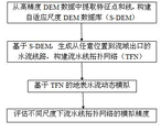
图1为本发明实施例的流程图。Fig. 1 is a flowchart of an embodiment of the present invention.
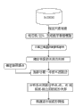
图2为本发明实施例的自适应尺度DEM建模流程图。Fig. 2 is a flow chart of adaptive scale DEM modeling according to an embodiment of the present invention.
图3为本发明实施例的建立流水线拓扑网络流程图。FIG. 3 is a flow chart of establishing a pipeline topology network according to an embodiment of the present invention.
图4为本发明实施例的地表水流动态模拟示意图。Fig. 4 is a schematic diagram of a dynamic simulation of surface water flow according to an embodiment of the present invention.
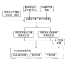
图5为本发明实施例的精度评价流程图。Fig. 5 is a flow chart of the accuracy evaluation of the embodiment of the present invention.
具体实施方法Specific implementation method
本发明要解决的核心问题是:构建一个基于自适应尺度DEM的流水线拓扑网络模型,进行多种尺度下的水流动态模拟,并保持不同尺度下结果的准确性和一致性,从而满足从广域到局部范围的多尺度或跨尺度应用需求,同时提高地表水流动态模拟的精度、使用范围和效率。The core problem to be solved by the present invention is to construct a pipeline topology network model based on self-adaptive scale DEM, carry out dynamic simulation of water flow at multiple scales, and maintain the accuracy and consistency of the results at different scales, so as to meet the needs of wide-area Multi-scale or cross-scale application requirements to a local scale, while improving the accuracy, scope and efficiency of surface water flow dynamic simulation.
实施例的流程参见附图1,采取一种基于自适应尺度DEM(S-DEM)的流水线拓扑网络(TFN)模型来实现地表水流的动态模拟。从高精度的DEM数据中提取特征点和线,构建基于河流网约束TIN的自适应尺度DEM数据库(S-DEM)。在此基础上,计算TIN中每一个三角形的水流方向,构建从任意位置到流域出口的水流线路,从而将三维的地形表达简化为一维的流水线拓扑结构(TFN),建立水流线间的拓扑关系,实现嵌套式的多尺度多层级拓扑结构,并利用经典的水文公式计算相关水文参量(如流速、流量),进行基于流水线拓扑结构的地表水流动态模拟,最后可以评估不同尺度下流水线拓扑网络的模拟精度,对模拟结果的精度加以验证。以下分步骤详细说明实施例的具体实施过程:Referring to Fig. 1 for the flow of the embodiment, a pipeline topology network (TFN) model based on adaptive scale DEM (S-DEM) is adopted to realize dynamic simulation of surface water flow. Feature points and lines are extracted from high-precision DEM data, and an adaptive scale DEM database (S-DEM) based on river network constraints TIN is constructed. On this basis, calculate the water flow direction of each triangle in the TIN, and construct the water flow line from any position to the outlet of the watershed, thereby simplifying the three-dimensional terrain expression into a one-dimensional pipeline topology (TFN), and establishing the topology between water flow lines relationship, realize nested multi-scale and multi-level topology structure, and use classical hydrological formulas to calculate relevant hydrological parameters (such as velocity, flow rate), and perform dynamic simulation of surface water flow based on pipeline topology structure, and finally evaluate pipeline topology at different scales The simulation accuracy of the network is used to verify the accuracy of the simulation results. The following sub-steps describe the specific implementation process of the embodiment in detail:
步骤1,基于自适应尺度DEM数据结构,按照指定尺度信息生成相应的不规则三角网。Step 1: Based on the self-adaptive scale DEM data structure, the corresponding irregular triangulation network is generated according to the specified scale information.
可预先从一个精细尺度DEM数据库中提取地形特征点、线,构建地形特征点、线与尺度之间的映射关系,为地形特征赋予尺度信息属性,从而构建S-DEM地形特征数据库。在实现本发明技术方案时,根据应用需求尺度从S-DEM地形特征数据库中自适应地提取满足该尺度条件的特征点、线,动态构建TIN,生成适应于该尺度的数字高程模型。一般由用户提供指定尺度信息,作为应用需求尺度。Topographic feature points and lines can be extracted from a fine-scale DEM database in advance, the mapping relationship between topographic feature points, lines and scales can be constructed, and scale information attributes can be assigned to topographic features, thereby constructing an S-DEM topographic feature database. When implementing the technical solution of the present invention, according to the application requirement scale, feature points and lines satisfying the scale condition are adaptively extracted from the S-DEM terrain feature database, a TIN is dynamically constructed, and a digital elevation model adapted to the scale is generated. Generally, the specified scale information is provided by the user as the application requirement scale.
具体实施时,构建保持地形特征的自适应尺度DEM的方法可参见武汉大学,周启鸣,一种保持地形特征的自适应尺度DEM建模方法,中国专利,201110033539,2011-07-13公开.For specific implementation, the method for constructing an adaptive scale DEM that maintains topographical features can be found in Wuhan University, Zhou Qiming, An adaptive scale DEM modeling method that maintains topographical features, Chinese patent, 201110033539, published on 2011-07-13.
为便于实施参考起见,提供实施例具体步骤如下,如图2:For the convenience of implementation and reference, the specific steps of the embodiment are provided as follows, as shown in Figure 2:
步骤1.1,对精细尺度DEM采用特征点提取算法和特征线提取算法,通过改变特征提取算法的参数,获得不同参数水平下的地形和水文特征,并构建TIN,与原始DEM进行精度比较,计算误差值。结合国家DEM精度规范,建立起误差值与尺度间的函数关系,最终归纳出参数与水文模型尺度之间的关系。Step 1.1, using the feature point extraction algorithm and feature line extraction algorithm for the fine-scale DEM, by changing the parameters of the feature extraction algorithm, obtain the topographic and hydrological features at different parameter levels, and construct a TIN, compare the accuracy with the original DEM, and calculate the error value. Combined with the national DEM accuracy specification, the functional relationship between the error value and the scale is established, and finally the relationship between the parameters and the scale of the hydrological model is summarized.
实施例首先利用现有最大z-tolerance算法,从精细尺度DEM数据库中提取地表的特征点,z-tolerance指定了由该等级下的特征点集生成的TIN容忍范围内的最大高程误差(记为z),随着z值的变化从原始精细尺度的DEM中检索出不同级别的地表的特征点。为了突出关键流域特征,再采取D8算法将补充的流域的特征线从原始精细尺度的DEM中识别出来,并加入到特征点集,基于地表的特征点和流域的特征线最后生成受流域约束的TIN。比较原始精细尺度的DEM和所得的不规则三角网,通过精度分析计算出最大高程误差z在不同取值下的均方根误差RMSE,对最大高程误差z和均方根误差RMSE进行曲线拟合,得到最大高程误差z和均方根误差RMSE之间的最佳函数解析表达式。The embodiment first uses the existing maximum z-tolerance algorithm to extract the feature points of the ground surface from the fine-scale DEM database. The z-tolerance specifies the maximum elevation error within the tolerance range of the TIN generated by the feature point set under this level (denoted as z), with the change of z value, the feature points of different levels of the surface are retrieved from the original fine-scale DEM. In order to highlight key watershed features, the D8 algorithm is used to identify the supplementary watershed feature lines from the original fine-scale DEM and add them to the feature point set. Based on the surface feature points and watershed feature lines, finally generate a watershed-constrained TIN. Compare the original fine-scale DEM with the obtained irregular triangulation, calculate the root mean square error RMSE of the maximum elevation error z at different values through precision analysis, and perform curve fitting on the maximum elevation error z and the root mean square error RMSE , to obtain the optimal functional analytical expression between the maximum elevation error z and the root mean square error RMSE.
步骤1.2,根据不同尺度的特征点集构建自适应尺度DEM数据结构。本步骤给地形特征赋予尺度属性。可利用各种相关规范和标准来进行基于尺度信息的特征点、线提取,从而得到符合规范的多尺度特征点、线。通过选取分级等间距尺度,计算指定尺度的特征点、线,构建初始分级尺度特征库,并从中提取特征点、线的尺度信息,给地形特征赋予尺度属性,构建S-DEM特征库。In step 1.2, an adaptive scale DEM data structure is constructed according to feature point sets of different scales. This step assigns scale attributes to terrain features. Various relevant specifications and standards can be used to extract feature points and lines based on scale information, so as to obtain multi-scale feature points and lines that meet the specifications. By selecting graded equidistant scales, calculating feature points and lines of specified scales, constructing an initial graded scale feature library, and extracting scale information of feature points and lines from it, assigning scale attributes to terrain features, and constructing an S-DEM feature library.
实施例首先根据制图规范中比例尺和等高距的关系,获取与尺度对应的z和RMSE取值范围,确定z的准确取值范围,再次利用CPE提取出不同尺度下的特征点;如果在某尺度下,存在有两个特征点的间距小于该尺度下栅格数字高程模型的格网单元间距,就只保留其中最大高程误差z取值较大的特征点;如果一个特征点和简化后流域线的间距与简化后流域线长度的比值小于设定的阈值,去除该特征点。Embodiment First, according to the relationship between the scale and the contour distance in the drawing specification, obtain the value range of z and RMSE corresponding to the scale, determine the accurate value range of z, and use CPE again to extract the feature points at different scales; if in a certain scale, if there are two feature points whose spacing is smaller than the grid cell spacing of the grid digital elevation model at this scale, only the feature point with a larger value of the maximum elevation error z will be kept; if a feature point and the simplified watershed If the ratio of the line spacing to the length of the simplified watershed line is less than the set threshold, the feature point is removed.
按照上述操作提取出符合规范的特征点集(特征线也可视为多个特征点)后,对各特征点赋予尺度属性,某个特征点的尺度属性为所有出现该特征点的尺度中的最粗尺度,表示从最精细尺度到该最粗尺度都包含该特征点;从而得到包含所有特征点的尺度属性图,构建出自适应尺度DEM数据结构。可以预先以数据库形式保存信息,即构建地形特征点、线与尺度之间的映射关系,为地形特征赋予尺度信息属性,得到尺度属性图,从而构建S-DEM地形特征数据库。After extracting the set of feature points conforming to the specification according to the above operations (feature lines can also be regarded as multiple feature points), assign scale attributes to each feature point, and the scale attribute of a feature point is all the scales where the feature point The coarsest scale means that the feature point is included from the finest scale to the coarsest scale; thus, a scale attribute map containing all feature points is obtained, and an adaptive scale DEM data structure is constructed. The information can be stored in the form of database in advance, that is, the mapping relationship between terrain feature points, lines and scales can be constructed, scale information attributes can be assigned to terrain features, and scale attribute maps can be obtained to construct the S-DEM terrain feature database.
步骤1.3,在不同尺度下进行自适应转化。对用户定制尺度,判断是否存在于S-DEM地形特征数据库中。如果存在,则从S-DEM特征库中提取该尺度下的特征点、线,动态构建TIN,建立数字高程模型;如果不存在,则通过判断准则从精细尺度下提取的特征中获取用户定制尺度的特征点、线,并对S-DEM地形特征数据库进行动态更新,这样还是可以从S-DEM地形特征数据库中检索出的特征点、线,动态构建TIN,建立数字高程模型;。Step 1.3, perform adaptive transformation at different scales. For user-defined scales, judge whether they exist in the S-DEM terrain feature database. If it exists, extract the feature points and lines at this scale from the S-DEM feature library, dynamically construct TIN, and establish a digital elevation model; if not, use the judgment criterion to obtain the user-defined scale from the features extracted at the fine scale The feature points and lines of the S-DEM terrain feature database are dynamically updated, so that the feature points and lines can still be retrieved from the S-DEM terrain feature database, and the TIN can be dynamically constructed to establish a digital elevation model;
当用户自行指定应用需求尺度时,如果用户指定尺度已存在于S-DEM地形特征数据库中,则该尺度下的特征点由尺度属性图中所有具有该尺度以及更粗尺度属性的特征点组成;如果用户指定尺度不存在于尺度属性图中,则重复以上步骤1.1和1.2提取出该尺度下的特征点,并对尺度属性图进行更新,该尺度下的特征点由更新后的尺度属性图中所有具有该尺度以及更粗尺度属性的特征点组成。When the user specifies the application requirement scale, if the scale specified by the user already exists in the S-DEM terrain feature database, the feature points under this scale are composed of all feature points with this scale and coarser scale attributes in the scale attribute map; If the scale specified by the user does not exist in the scale attribute map, repeat the above steps 1.1 and 1.2 to extract the feature points at this scale, and update the scale attribute map, and the feature points at this scale are determined by the updated scale attribute map All feature points with this scale and coarser scale attributes.
步骤2,计算步骤1所得不规则三角网中每个三角面的水流方向线,构建从任意位置到流域出口的水流路径,根据所得水流路径建立流水线拓扑网络。Step 2. Calculate the water flow direction line of each triangular surface in the irregular triangular network obtained in step 1, construct a water flow path from any position to the outlet of the basin, and establish a pipeline topology network based on the obtained water flow path.
实施例在自适应尺度S-DEM地形表达的基础上,计算TIN中每一个三角形的水流方向,构建从任意位置到流域出口的水流线路,从而将三维的地形表达简化为一维的拓扑流水线结构,建立水流线间的拓扑关系,实现嵌套式的多尺度多层级拓扑结构,即流水线拓扑网络(TFN)。参见附图3,实施例具体步骤如下:The embodiment calculates the water flow direction of each triangle in the TIN on the basis of the adaptive scale S-DEM terrain expression, and constructs a water flow line from any position to the outlet of the watershed, thereby simplifying the three-dimensional terrain expression into a one-dimensional topological pipeline structure , establish the topological relationship between pipelines, and realize the nested multi-scale and multi-level topology structure, that is, the pipeline topology network (TFN). Referring to accompanying drawing 3, embodiment concrete steps are as follows:
步骤2.1,对不规则三角网划分规则的网格,并在每个格网中随机选取一个采样点作为降雨源点。In step 2.1, the irregular triangular network is divided into regular grids, and a sampling point is randomly selected in each grid as the rainfall source point.
本步骤实现对地表水源点(如降雨源点)进行采样。步骤1已根据指定尺度信息从S-DEM特征库中提取特征点、线,动态生成受流域约束的TIN,生成数字高程模型。TIN结构使得地表和水源点采样能够分离,通过对比分析不同的采样方法,如规则格网采样、随机采样和限制性随机采样,采取一种基于格网限制的随机采样方法,即将区域范围的地表TIN划分为规则格网,并在每个格网中随机选取一个采样点作为降雨源点。该降雨源点作为流水线追踪的起点。This step implements sampling of surface water source points (such as rainfall source points). Step 1 has extracted feature points and lines from the S-DEM feature library according to the specified scale information, dynamically generated TIN subject to watershed constraints, and generated a digital elevation model. The TIN structure enables the separation of surface and water source point sampling. By comparing and analyzing different sampling methods, such as regular grid sampling, random sampling and restricted random sampling, a random sampling method based on grid restrictions is adopted, that is, the area-wide surface The TIN is divided into regular grids, and a sampling point is randomly selected in each grid as the rainfall source point. The rainfall source point is used as the starting point of pipeline tracking.
步骤2.2,通过计算不规则三角网上每个三角面的坡度和坡向,得到每个三角面的水流方向线,以任一降雨源点为起点,按照水流方向线追踪,构建得到从任意位置到流域出口的水流路径。Step 2.2, by calculating the slope and aspect of each triangular surface on the irregular triangular network, the water flow direction line of each triangular surface is obtained, starting from any rainfall source point, tracing according to the water flow direction line, and constructing from any position to The water flow path at the outlet of the watershed.
本步骤生成动态不规则三角网(TIN)中每个三角面的水流方向,从而确定目标区域内的任意一点到流域出口的水流方向。通过计算TIN上每个面恒定的坡向和坡度,得到各面三维的水流方向线。以目标区域内任意一降雨源点为起点,按照水流方向,依次追踪得到流水线。相邻三角面的地表水流存在多种可能的流动方式,根据这些水流方式追踪得到每一滴雨水从落到地面到流域出口的水流路径,即可以追踪任意一点的水流路径。This step generates the water flow direction of each triangular surface in the dynamic triangular irregular network (TIN), so as to determine the water flow direction from any point in the target area to the outlet of the watershed. By calculating the constant aspect and slope of each surface on the TIN, the three-dimensional flow direction lines of each surface are obtained. Starting from any rainfall source point in the target area, follow the direction of water flow to trace the pipeline in sequence. There are many possible flow modes for the surface water flow on adjacent triangular faces. According to these flow modes, the water flow path of each drop of rainwater from falling on the ground to the outlet of the basin can be traced, that is, the water flow path at any point can be traced.
在实施例中,受流域约束的TIN上每个三角面都具有恒定的坡度和坡向,三角面的三个结点可采用三维坐标x、y、z的形式表示为P1(x1,y1,z1),P2(x2,y2,z2)和P3(x3,y3,z3),整个三角面就表示为In the embodiment, each triangular surface on the TIN constrained by the watershed has a constant slope and aspect, and the three nodes of the triangular surface can be expressed as P 1 (x 1 , y 1 , z 1 ), P 2 (x 2 , y 2 , z 2 ) and P 3 (x 3 , y 3 , z 3 ), the entire triangle is expressed as
z=f(x,y)=ax+by+cz=f(x,y)=ax+by+c
从而每个三角面的坡度和坡向可表示为Therefore, the slope and aspect of each triangle can be expressed as

通过TIN上每个三角面恒定的坡度和坡向,得到代表三角面水流方向的水流方向线PQ,其中P点三维坐标为(xP,yP,zP),Q点三维坐标为(xQ,yQ,zQ)。PQ的方向表示面的坡向,长度表示面的坡度。通过P点的坐标、坡度(β)和坡向(α)计算出Q点的坐标:Through the constant slope and aspect of each triangular surface on the TIN, the water flow direction line PQ representing the water flow direction of the triangular surface is obtained, where the three-dimensional coordinates of point P are (x P , y P , z P ), and the three-dimensional coordinates of point Q are (x Q ,y Q ,z Q ). The direction of PQ represents the slope aspect of the surface, and the length represents the slope of the surface. The coordinates of point Q are calculated from the coordinates of point P, slope (β) and aspect (α):
其中,f1(.)、f2(.)和f3(.)表示相应计算函数,具体计算实现属于现有技术。Among them, f 1 (.), f 2 (.) and f 3 (.) represent corresponding calculation functions, and the specific calculation implementation belongs to the prior art.
相邻三角面的地表水流存在三种可能的流动方式:There are three possible flow modes for surface water flow on adjacent triangular faces:
1.如果相邻三角面的流向背离公共边,则水流路径穿过相邻三角面;1. If the flow direction of adjacent triangular faces deviates from the common side, the water flow path passes through the adjacent triangular faces;
2.如果相邻三角面的流向指向公共边,则表示地表水流到达一个V形山谷,水流路径沿此公共边流向下游结点;2. If the flow direction of adjacent triangular faces points to the common side, it means that the surface water flow reaches a V-shaped valley, and the water flow path flows along the common side to the downstream node;
3.如果V形山谷的公共边终止(既没有相连的下游V形边),则水流向着具有下游最陡坡降的三角面流动。如果找不到这样的三角面,水流路径结束。3. If the common edge of the V-shaped valley terminates (neither has a connected downstream V-shaped edge), the water flows towards the triangular face with the steepest downstream slope. If no such triangle is found, the flow path ends.
计算出每个三角面的水流方向线后,就能根据以上水流方式,追踪得到每一滴雨水从落到地面到流域出口的水流路径。一条水流路径由多个三角面上的水流线段接续构成。如果邻近的三角面或公共边是平坦的,即三角面的坡度为零,则无法确定该三角面的水流方向。为了消除平坦区域中不明确的水流方向,可采取一种重复的深度搜索法对该区域内的三角面进行搜索,直到能够确定水流方向。After calculating the water flow direction line of each triangular surface, the water flow path of each drop of rainwater from falling to the ground to the outlet of the watershed can be traced according to the above water flow method. A water flow path is formed by connecting water flow line segments on multiple triangular surfaces. If the adjacent triangular faces or the common edge are flat, that is, the slope of the triangular face is zero, then the flow direction of the triangular face cannot be determined. In order to eliminate the ambiguous water flow direction in the flat area, a repeated depth search method can be used to search the triangular faces in the area until the water flow direction can be determined.
步骤2.3,基于步骤2.2所得水流路径,建立流水线拓扑网络。In step 2.3, a pipeline topology network is established based on the water flow path obtained in step 2.2.
实施例基于步骤2.2所得三维的水流路径,分析各水流路径中点-点、点-线和线-线之间的拓扑关系,建立存储基于结点和水流线段的点-点、点-线和线-线之间的拓扑关系,构建一维的流水线拓扑网络。该拓扑网络包含两个表,一个存储结点信息,如结点ID,X、Y、Z坐标,以及其他水文参数,如降雨源点的植被类型,土壤湿度等信息;另一个存储结点-线段信息,如始末结点ID,各种水文参数,如水流线段的坡度、长度、流速。其中水流线段的流速可通过一些经典的水文公式推导出来,本实施例中采用Manning公式,即v=R2/3.S1/2/n,其中v表示流速(m/s),R表示水文半径(m),可通过水流深度估算出,S表示坡度,n表示曼宁阻力系数。Embodiment Based on the three-dimensional water flow path obtained in step 2.2, analyze the topological relationship between point-point, point-line and line-line in each water flow path, and establish and store point-point, point-line and The topological relationship between lines and lines is used to construct a one-dimensional pipeline topology network. The topology network contains two tables, one stores node information, such as node ID, X, Y, Z coordinates, and other hydrological parameters, such as vegetation type of rainfall source point, soil moisture and other information; the other stores node- Line segment information, such as the beginning and end node ID, various hydrological parameters, such as the slope, length, and flow velocity of the water flow line segment. Wherein the flow velocity of the water flow line section can be deduced by some classical hydrological formulas, and the Manning formula is adopted in this embodiment, that is, v=R 2/3 .S 1/2 /n, wherein v represents the flow velocity (m/s), and R represents The hydrological radius (m) can be estimated by the water flow depth, S represents the slope, and n represents the Manning resistance coefficient.
在实施例中,各水流线段间的拓扑关系能够自动从存储线段信息的表中生成,由于各水流线段存储了始末结点ID,而且两条相邻线段必须共享同一结点,所以上游水流线段的末结点ID就是下游水流线段的起结点ID。比如,线段(213)的末结点ID(616)与线段(214)的起结点ID(616)相同,就意味着线段(214)位于线段(213)的下游。类似的,可以提取出所有水流线段的上下游拓扑关系,并在表中存储线段ID和与之相邻的下游线段ID。In the embodiment, the topological relationship between each water flow line segment can be automatically generated from the table storing line segment information. Since each water flow line segment stores the start and end node IDs, and two adjacent line segments must share the same node, the upstream water flow line segment The end node ID of is the start node ID of the downstream water flow line segment. For example, the end node ID (616) of the line segment (213) is the same as the start node ID (616) of the line segment (214), which means that the line segment (214) is located downstream of the line segment (213). Similarly, the upstream and downstream topological relationships of all water flow line segments can be extracted, and the line segment ID and the adjacent downstream line segment IDs can be stored in the table.
步骤3,基于步骤2所得流水线拓扑网络,进行地表水流动态模拟。可以根据模拟的降雨数据和/或真实环境下的降雨数据以及各种环境参量,可以引入水文公式,计算流速,进行水流动态模拟。具体实施时,可以在只考虑重力因素的情况下进行地表水流动态模拟。也可以在考虑重力因素和其他环境变量的情况下进行地表水流动态模拟。这两种方式所得模拟结果都具有技术意义,具体实施时可根据用户需要任选其一,或者都选用。对后一种方式,可以对真实环境下的降雨数据采取多种现有的水文模型模拟产流,再利用各模型的产流数据分别基于TFN进行水流动态模拟。参见附图4,实施例先后采用两种方式,具体步骤如下:Step 3, based on the pipeline topology network obtained in step 2, perform dynamic simulation of surface water flow. According to the simulated rainfall data and/or the rainfall data in the real environment and various environmental parameters, hydrological formulas can be introduced to calculate the flow velocity and perform water flow dynamic simulation. In specific implementation, the dynamic simulation of surface water flow can be carried out under the condition that only the gravity factor is considered. Simulations of surface water flow dynamics can also be performed taking gravity and other environmental variables into account. The simulation results obtained by these two methods are of technical significance, and one or both of them can be selected according to the needs of users during specific implementation. For the latter method, a variety of existing hydrological models can be used to simulate runoff for rainfall data in real environments, and then the runoff data of each model can be used to simulate water flow dynamics based on TFN. Referring to accompanying drawing 4, embodiment adopts two ways successively, concrete steps are as follows:
步骤3.1,针对模拟的降雨过程(计算机模拟,非真实降雨数据),模拟一段时间内时空均匀分布和非均匀分布的降雨过程,在只考虑重力因素,暂不考虑下渗、蒸发等其他水文过程的情况下,根据上述步骤2得到的流水线拓扑网络,选择经典的水文公式计算出每条线段的流速,从而获得降雨区域的任意一点在任意时间段的降雨-径流模拟曲线。Step 3.1, for the simulated rainfall process (computer simulation, non-real rainfall data), simulate the rainfall process with uniform and non-uniform distribution in time and space for a period of time, only considering the gravity factor, and not considering other hydrological processes such as infiltration and evaporation for the time being In the case of , according to the pipeline topology network obtained in the above step 2, the classical hydrological formula is selected to calculate the flow velocity of each line segment, so as to obtain the rainfall-runoff simulation curve at any point in the rainfall area at any time period.
在实施例中,选取一块1091×892的分辨率为5m的DEM作为实验区域,模拟一段20分钟内从东南至西北的12mm的降雨。通过时间和空间的插值,获取格网限制下随机采样的降雨数据,由于只考虑重力因素,不考虑下渗、蒸发等,因此所有降雨都用于产流。按照以上步骤建立流水线拓扑网络,并根据Manning公式计算出各水流线段的流速,选取一系列时间间隔(如t=9s、127s、402s、734s、938s、1120s),计算出各水流路径中的实时流量,并分别选取上中下游三个地点进行检测,生成各点在该时间段的降雨-径流模拟曲线。In the embodiment, a DEM with a resolution of 1091×892 and a resolution of 5m is selected as the experimental area, and a 12mm rainfall from southeast to northwest within a period of 20 minutes is simulated. Through temporal and spatial interpolation, random sampling of rainfall data under grid constraints is obtained. Since only gravity is considered and infiltration, evaporation, etc. are not considered, all rainfall is used for runoff production. According to the above steps, the pipeline topology network is established, and the flow velocity of each water flow line segment is calculated according to the Manning formula, and a series of time intervals (such as t=9s, 127s, 402s, 734s, 938s, 1120s) are selected to calculate the real-time flow rate in each water flow path. Flow, and three locations in the upper, middle and lower reaches were selected for detection, and the rainfall-runoff simulation curve of each point in the time period was generated.
步骤3.2,利用真实的降雨数据,不仅考虑重力因素,而且综合考虑截留、下渗、蒸发等各个水文过程(加入环境和气象因素,如土地覆盖和利用类型、叶面积指数、气温和地表温度等),采用现有的水文模型(如SWAT,SHE)计算出产流数据,然后根据流水线拓扑网络动态模拟出不同时间下的汇流结果。Step 3.2, using real rainfall data, not only considering gravity factors, but also comprehensively considering various hydrological processes such as interception, infiltration, evaporation (adding environmental and meteorological factors, such as land cover and use type, leaf area index, air temperature and surface temperature, etc. ), using existing hydrological models (such as SWAT, SHE) to calculate runoff data, and then dynamically simulate the confluence results at different times according to the pipeline topology network.
在实施例中,选择泾河流域作为真实环境下的实验区域,采取一块3872×4937的分辨率为90m的DEM,按照以上步骤生成流水线拓扑网络。根据2005年的日降雨数据、环境和气象因素(土地覆盖和利用类型、叶面积指数、气温和地表温度等),采取SWAT、SHE等水文模型先计算出产流数据,再利用产流数据和流水线拓扑网络模拟出不同时间下两个主要流量监测站点所在位置的汇流结果。同样可以获得降雨区域的任意一点在任意时间段的降雨-径流模拟曲线。In the embodiment, the Jinghe River Basin is selected as the experimental area in the real environment, a 3872×4937 DEM with a resolution of 90m is taken, and the pipeline topology network is generated according to the above steps. According to the daily rainfall data in 2005, environmental and meteorological factors (land cover and use type, leaf area index, air temperature and surface temperature, etc.), hydrological models such as SWAT and SHE are used to calculate the runoff data first, and then use the runoff data and the assembly line The topological network simulates the confluence results of the locations of the two main flow monitoring stations at different times. Similarly, the rainfall-runoff simulation curve at any point in the rainfall area at any time period can be obtained.
为了验证多尺度下流水线拓扑网络的动态模拟精度,本发明实施例最后对不同尺度下的模拟结果进行评价。此处模拟结果是指对采用水文模型所得考虑重力因素和其他环境变量的模拟结果。参见附图5,实施例具体步骤如下:In order to verify the dynamic simulation accuracy of the pipeline topology network at multiple scales, the embodiment of the present invention finally evaluates the simulation results at different scales. The simulation results here refer to the simulation results obtained by using the hydrological model considering the gravity factor and other environmental variables. Referring to accompanying drawing 5, embodiment concrete steps are as follows:
步骤a,对于现有的水文模型(如SWAT,SHE),需将精细尺度DEM重采样成多种粗尺度下的DEM,进行多尺度情况的模拟、对比和分析。在不同尺度下结合环境和气象参数,采用水文模型计算得到产流数据,然后分别采用本发明所得流水线拓扑网络(TFN)、现有的水文模型(如SWAT,SHE,与步骤3.2计算产流数据的水文模型一致)模拟出汇流结果。Step a, for the existing hydrological models (such as SWAT, SHE), it is necessary to resample the fine-scale DEM into a variety of coarse-scale DEMs for multi-scale simulation, comparison and analysis. Combined with environmental and meteorological parameters at different scales, the hydrological model is used to calculate the runoff data, and then the pipeline topology network (TFN) obtained in the present invention, the existing hydrological model (such as SWAT, SHE, and step 3.2) are used to calculate the runoff data Consistent with the hydrological model) to simulate the confluence results.
在实施例中,需对原始的90m分辨率的DEM进行重采样,选择一系列的尺度,如分辨率为150m、250m、500m、1000m等。在不同尺度下结合降雨数据、环境和气象因素,采用SWAT和SHE模型计算出产流和汇流数据。根据不同的尺度从自适应尺度DEM数据库(S-DEM)中提取相应的特征点、线,构建该尺度下的受流域约束的TIN,并按照步骤2生成流水线拓扑网络。再根据各水文模型得到的产流数据,采用流水线拓扑网络、水文模型分别模拟出汇流结果,以便进行在不同尺度下水流模拟结果的比较。In the embodiment, the original 90m resolution DEM needs to be resampled, and a series of scales are selected, for example, the resolutions are 150m, 250m, 500m, 1000m and so on. Combined with rainfall data, environmental and meteorological factors at different scales, the SWAT and SHE models are used to calculate runoff and confluence data. Extract the corresponding feature points and lines from the self-adaptive scale DEM database (S-DEM) according to different scales, construct the TIN constrained by the watershed at this scale, and generate the pipeline topology network according to step 2. Then, according to the runoff data obtained by each hydrological model, the pipeline topology network and hydrological model were used to simulate the confluence results respectively, so as to compare the simulation results of water flow at different scales.
步骤b,选取常用的水文统计参数作为水流模拟的评价指标,如Nash效率系数E,用于评估水文模型的预测能力;相关系数R,用于衡量实测流量与模拟流量的相关性;平衡系数B,用于表示实测流量与模拟流量的比值。这三种系数越接近1,表示模拟的结果越精确。分别根据步骤a的模拟结果和水文实测数据评价计算出水文统计参数指标,具体计算属于现有技术。通过进行对比检验,得到各种水文方法在不同尺度下模拟地表水流的准确性和一致性。In step b, the commonly used hydrological statistical parameters are selected as evaluation indicators for water flow simulation, such as the Nash efficiency coefficient E, which is used to evaluate the predictive ability of the hydrological model; the correlation coefficient R, which is used to measure the correlation between the measured flow rate and the simulated flow rate; the balance coefficient B , which is used to represent the ratio of the measured flow rate to the simulated flow rate. The closer these three coefficients are to 1, the more accurate the simulation results are. The hydrological statistical parameter index is calculated according to the simulation result of step a and the hydrological actual measurement data evaluation, and the specific calculation belongs to the prior art. The accuracy and consistency of various hydrological methods for simulating surface water flow at different scales are obtained through comparative testing.
以上所述仅为本发明中的一个实施例,并不用于限制本发明。例如直接利用本发明步骤3的模拟结果,不进行评价。凡在本发明的精神与原则之内,所做的任何修改,改进等,均应包含在本发明的保护范围之内。The above description is only an embodiment of the present invention, and is not intended to limit the present invention. For example, the simulation results of step 3 of the present invention are directly used without evaluation. All modifications, improvements, etc. made within the spirit and principles of the present invention shall be included within the protection scope of the present invention.
Claims (3)
Priority Applications (1)
| Application Number | Priority Date | Filing Date | Title |
|---|---|---|---|
| CN201210167885.5A CN102722909B (en) | 2012-05-28 | 2012-05-28 | Assembly line topology network dynamic simulation method based on adaptive-dimensional DEM (dynamic effect model) |
Applications Claiming Priority (1)
| Application Number | Priority Date | Filing Date | Title |
|---|---|---|---|
| CN201210167885.5A CN102722909B (en) | 2012-05-28 | 2012-05-28 | Assembly line topology network dynamic simulation method based on adaptive-dimensional DEM (dynamic effect model) |
Publications (2)
| Publication Number | Publication Date |
|---|---|
| CN102722909A CN102722909A (en) | 2012-10-10 |
| CN102722909B true CN102722909B (en) | 2014-07-02 |
Family
ID=46948655
Family Applications (1)
| Application Number | Title | Priority Date | Filing Date |
|---|---|---|---|
| CN201210167885.5A Expired - Fee Related CN102722909B (en) | 2012-05-28 | 2012-05-28 | Assembly line topology network dynamic simulation method based on adaptive-dimensional DEM (dynamic effect model) |
Country Status (1)
| Country | Link |
|---|---|
| CN (1) | CN102722909B (en) |
Families Citing this family (18)
| Publication number | Priority date | Publication date | Assignee | Title |
|---|---|---|---|---|
| CN102915547B (en) * | 2012-10-12 | 2016-03-02 | 吴立新 | A kind of water catchment area division methods based on triangle surface |
| CN102930146B (en) * | 2012-10-18 | 2015-07-15 | 中国人民解放军信息工程大学 | Method for quantitatively evaluating fidelity precision of digital elevation model |
| CN103236086B (en) * | 2013-04-24 | 2016-04-13 | 武汉大学 | One takes the contextual multiple dimensioned DEM modeling method of the earth's surface hydrology into account |
| CA2908934C (en) * | 2013-05-09 | 2021-04-27 | Landmark Graphics Corporation | Gridless simulation of a fluvio-deltaic environment |
| CN103473809B (en) * | 2013-09-27 | 2016-01-27 | 武汉大学 | Based on the valley water security management method of 3D printing technique |
| CN103677826B (en) * | 2013-12-09 | 2017-01-04 | 河海大学 | Watershed partitioning based on IDL and Mapinfo and information extracting method |
| CN106202265B (en) * | 2016-06-29 | 2019-03-19 | 武汉大学 | Large scale Complex River magnanimity fine regular grid in basin draws volume method |
| CN106845116B (en) * | 2017-01-23 | 2019-07-23 | 中国水利水电科学研究院 | A kind of flood forecast system of river system |
| CN107944194B (en) * | 2017-12-15 | 2020-07-10 | 武汉大学 | Terrain humidity index simulation method based on vector network |
| CN108647900B (en) * | 2018-05-18 | 2022-03-11 | 北京科技大学 | Region division method applied to hydrological simulation field |
| CN109447028A (en) * | 2018-11-12 | 2019-03-08 | 南京大学 | A kind of farmland ditch network extraction method |
| CN109932368B (en) * | 2019-04-02 | 2021-06-18 | 北京林业大学 | A method for measuring the drag coefficient of flexible vegetation groups |
| CN110990780B (en) * | 2019-10-29 | 2021-11-02 | 西北农林科技大学 | A Slope Extraction Method Based on SRTM Data |
| CN112464493B (en) * | 2020-12-10 | 2023-03-07 | 中国电建集团昆明勘测设计研究院有限公司 | Improved Model, Regional Runoff and Flood Risk Design Method Based on TOPMODEL Model |
| CN113987969A (en) * | 2021-10-26 | 2022-01-28 | 严大莲 | Land-water dynamic simulation model of multi-elevation scale water flow network |
| CN115600448B (en) * | 2022-01-24 | 2025-10-31 | 安徽建筑大学 | Surface water dynamic simulation parallelization method based on pipeline network |
| CN114155350B (en) * | 2022-02-07 | 2022-04-22 | 北京恒济引航科技股份有限公司 | Underwater terrain erosion and deposition evolution analysis method and device for channel |
| CN120848588B (en) * | 2025-09-18 | 2025-12-12 | 杭州市北京航空航天大学国际创新研究院(北京航空航天大学国际创新学院) | Unmanned aerial vehicle network system phase point track modeling accuracy analysis method, system and software product |
Citations (3)
| Publication number | Priority date | Publication date | Assignee | Title |
|---|---|---|---|---|
| CN101051390A (en) * | 2007-05-15 | 2007-10-10 | 北京金山软件有限公司 | Method and system for simulating river |
| CN101221598A (en) * | 2008-01-28 | 2008-07-16 | 北京地拓科技发展有限公司 | Method for generating dam topological view used for small river basin dam planning |
| CN102122395A (en) * | 2011-01-31 | 2011-07-13 | 武汉大学 | Adaptive scale DEM (digital elevation model) modeling method capable of keeping terrain features |
Family Cites Families (1)
| Publication number | Priority date | Publication date | Assignee | Title |
|---|---|---|---|---|
| WO2003090184A1 (en) * | 2002-04-22 | 2003-10-30 | Dgs Computer | Digital altimetric map drawing method and device |
-
2012
- 2012-05-28 CN CN201210167885.5A patent/CN102722909B/en not_active Expired - Fee Related
Patent Citations (3)
| Publication number | Priority date | Publication date | Assignee | Title |
|---|---|---|---|---|
| CN101051390A (en) * | 2007-05-15 | 2007-10-10 | 北京金山软件有限公司 | Method and system for simulating river |
| CN101221598A (en) * | 2008-01-28 | 2008-07-16 | 北京地拓科技发展有限公司 | Method for generating dam topological view used for small river basin dam planning |
| CN102122395A (en) * | 2011-01-31 | 2011-07-13 | 武汉大学 | Adaptive scale DEM (digital elevation model) modeling method capable of keeping terrain features |
Also Published As
| Publication number | Publication date |
|---|---|
| CN102722909A (en) | 2012-10-10 |
Similar Documents
| Publication | Publication Date | Title |
|---|---|---|
| CN102722909B (en) | Assembly line topology network dynamic simulation method based on adaptive-dimensional DEM (dynamic effect model) | |
| Yang et al. | Comparison of different distributed hydrological models for characterization of catchment spatial variability | |
| Xiao et al. | Geostatistical interpolation model selection based on ArcGIS and spatio-temporal variability analysis of groundwater level in piedmont plains, northwest China | |
| Krajewski et al. | Real-time flood forecasting and information system for the state of Iowa | |
| Mitasova et al. | Modelling topographic potential for erosion and deposition using GIS | |
| Mott et al. | Understanding snow-transport processes shaping the mountain snow-cover | |
| Zhou et al. | Generalization of DEM for terrain analysis using a compound method | |
| CN104298841B (en) | A kind of Flood Forecasting Method and system based on historical data | |
| Garen et al. | Mean areal precipitation for daily hydrologic modeling in mountainous regions 1 | |
| Khatami et al. | Benefits of GIS application in hydrological modeling: A brief summary | |
| Yang et al. | Migration of barchan dunes in the western Quruq Desert, northwestern China | |
| CN109584510A (en) | A kind of road landslide of high slope disaster alarm method based on valuation functions training | |
| Zhao et al. | Effects of wind velocity and Nebkha geometry on shadow dune formation | |
| CN103234920A (en) | Underground water enrichment assessment method based on remote sensing information | |
| CN119808663B (en) | Flood inundation calculation method, equipment and medium suitable for wetting mountain areas | |
| Mitasova et al. | GIS tools for erosion/deposition modelling and multidimensional visualization | |
| Namitha et al. | Ground water flow modelling using visual modflow | |
| CN113408201B (en) | Landslide susceptibility evaluation method based on terrain unit | |
| Mendicino | Sensitivity analysis on GIS procedures for the estimate of soil erosion risk | |
| Mashee et al. | Dem imagery for investigation and verification Najaf-Karbala Hill Formation by use remote sensing techniques | |
| Jwan et al. | Developing three-dimensional groundwater flow modeling for the Erbil Basin using Groundwater Modeling System (GMS) | |
| Kumar et al. | Spatial distribution of rainfall with elevation in Satluj river basin: 1986-2010, Himachal Pradesh, India | |
| Rasel et al. | Geospatial analysis of groundwater level variations using Kriging Method | |
| Liu et al. | [Retracted] Flood Simulation Analysis of the Biliu River Basin Based on the MIKE Model | |
| CN119129368A (en) | A soil moisture movement inversion method and system based on soil moisture distribution |
Legal Events
| Date | Code | Title | Description |
|---|---|---|---|
| C06 | Publication | ||
| PB01 | Publication | ||
| C10 | Entry into substantive examination | ||
| SE01 | Entry into force of request for substantive examination | ||
| C14 | Grant of patent or utility model | ||
| GR01 | Patent grant | ||
| CF01 | Termination of patent right due to non-payment of annual fee |
Granted publication date: 20140702 Termination date: 20150528 |
|
| EXPY | Termination of patent right or utility model |