Method for quickly matching positions of personnel and map in fire rescue
Technical Field
The invention relates to a map matching system and a map matching method, in particular to a system and a method for quickly matching positions of personnel and a map in fire rescue.
Background
According to investigation, among various disasters, fire disasters become one of the most frequent disasters which threaten the safety of lives and properties of people. Most of fire disasters occur in indoor environments, and when firefighters enter disaster sites to rescue, if outdoor personnel cannot determine the indoor positions of the firefighters, the safety of the firefighters and reasonable scheduling of the firefighters are difficult to guarantee. Therefore, it is necessary to develop a method for rapidly matching the location of the firefighter with the map.
In the existing map matching technology, most of the map matching technologies aim at map matching in an outdoor environment, the technical research of indoor map matching is neglected, and the common indoor map matching technology has the following two problems that the technology capable of realizing more accurate positioning can not be matched in real time, and the technology capable of realizing real-time matching is not high in precision. Therefore, it is of great significance to research a method for matching the position of the person with the map, wherein the method can be used for matching quickly and has high precision.
Disclosure of Invention
Aiming at the defects of the prior art, the invention provides a system and a method for quickly matching the position of a firefighter with a map in fire rescue, and solves the problems that the position of the firefighter in a room is difficult to determine in the fire rescue process, the matching precision of indoor map matching is insufficient, real-time matching cannot be realized, and the like.
The technical scheme of the invention is as follows:
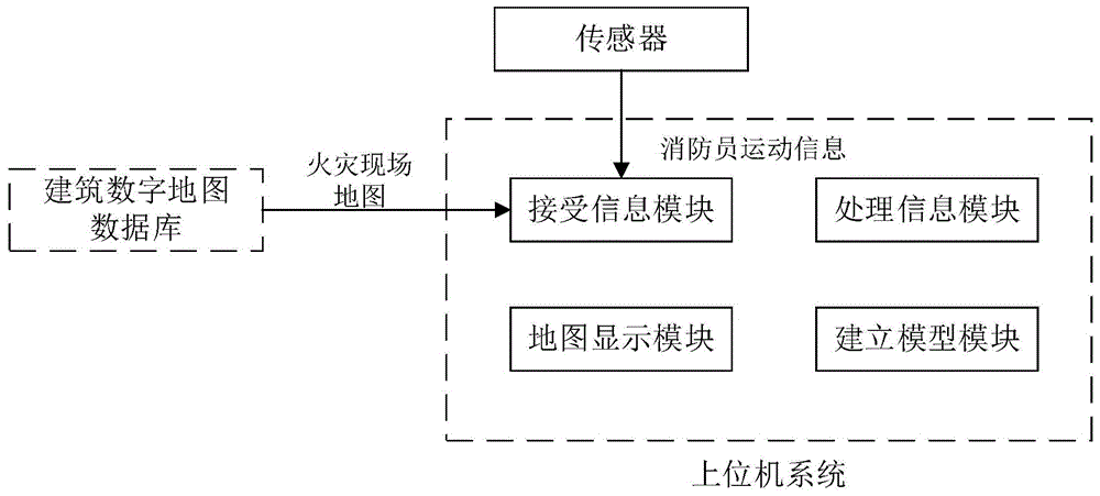
a system for quickly matching the position of a person with a map in fire rescue comprises an upper computer system and a building digital map database; the upper computer system comprises an information receiving module, an information processing module, a map display module and a model establishing module; the information receiving module is connected with a sensor and receives firefighter movement information acquired by the sensor; the motion information comprises acceleration, angular velocity and/or magnetic field strength; the information receiving module is connected with the building digital map database and receives the fire scene map information provided by the building digital map database; the information processing module is connected with the information receiving module and used for processing the received firefighter motion information and the map information of the fire scene and matching the position of the firefighter with the map; the map display module is connected with the information receiving module and used for displaying the fire scene map imported from the building digital map database; and the model building module is used for building a space three-dimensional coordinate system of a fire scene on an interface of the upper computer system.
The further technical scheme is that the information receiving module receives the motion information and corrects errors when a firefighter falls on the ground with a single foot in the moving process.
The further technical scheme is that the information processing module processes the received firefighter motion information by adopting a Kalman filtering algorithm, an inertial navigation algorithm and pedestrian dead reckoning.
The further technical scheme is that the display mode of the space three-dimensional coordinate system comprises grid display, graduation display and/or coordinate axis display.
The further technical proposal is that a building digital map database stores a plurality of building maps; the building map comprises an image map and a three-dimensional map; the architectural map includes a variety of map scales.
A method for quickly matching the position of a person with a map in fire rescue comprises the following steps:
step S1, initializing the upper computer system, and emptying the data stored in the upper computer system; importing a required map into an upper computer system from a building digital map database, and selecting a display mode of a space three-dimensional coordinate system of a fire scene in the upper computer system;
step S2, the upper computer system starts to operate; the information receiving module receives firefighter movement information from the sensor and map information from the building digital map database and transmits the information to the information processing module; the information processing module processes the received firefighter movement information to obtain the position coordinates and the movement track of the firefighter in the space three-dimensional coordinate system; the information processing module carries out filtering processing on the received map information to improve the image resolution;
step S3, the information processing module runs a matching algorithm; matching by using the position coordinates of the firefighters; matching by comparing the similarity between the walking track of the firefighter and the path of the fire scene;
s4, the information processing module performs error correction on the matching error of the firefighter in the moving process;
step S5, completing the matching of the position of the personnel and the map in the fire rescue process after the matching algorithm and the error correction;
step S6, finishing the rescue work and evacuating the firemen from the fire scene; the system stops working, a disaster site map with a space three-dimensional coordinate system is automatically stored, and an independent file is generated for the movement track of each firefighter in the rescue process.
A further technical solution is that the matching algorithm in step S3 specifically includes:
step S31, after the information processing module obtains the position coordinates of the firefighter, the obtained road which the firefighter is most likely to pass through is calculated by using a vertical projection algorithm, and the movement probability of the firefighter on each road section which the firefighter is likely to pass through is calculated according to the following formula:
γi=wr*ri+wθ*θi (1)
in the formula (1) < gamma >, (iIndicating the probability of a firefighter walking on a road that the firefighter is likely to pass, riIndicating the length of a road likely to be traversed, thetaiIndicating the angle, w, between the direction of travel of the firefighter and the road on which it is likely to passrIs represented by riThe ratio of weight, w, in the algorithmθDenotes thetaiThe proportion of the weight of the algorithm is i, which represents the number of each road which is possibly passed through; according to the probability gammaiJudging the road which the firefighter is most likely to pass through;
s32, matching the walking track of the firefighter with the similarity of the map path; the walking track is divided into a plurality of sections, and the sections with the walking track similar to the map path are judged by an on-line scanning method, so that the section where the firefighter is most likely to be located is obtained.
The further technical solution is that the error correction in step S4 includes automatic error correction and manual error correction; specifically, the information processing module automatically corrects the matching error of the firefighter in the moving process; then judging whether the situation is the situation that manual error correction is needed; when manual error correction is needed, after a cursor of a firefighter on a map is moved for a certain distance, the upper computer system recalculates the position of the firefighter; when the manual error correction is not necessary, the process returns to step S3.
A further technical solution is that the error correction in step S4 specifically includes:
step S41, after matching is completed, step S42 and step S43 are carried out, and two moments with the maximum error probability in the matching process are judged; the two moments with the maximum error probability are the moment when the walking track of the firefighter is overlapped with the edge of the marker and the moment when the firefighter reaches the road intersection;
step S42, judging whether the walking track of the firefighter is overlapped with the edge of the marker; if not, go back to step S3; if so, repositioning by adopting a local correction method; specifically, an included angle between a walking track of a fireman and a boundary line of the marker is calculated; when the included angle is smaller than the critical value, the system prompts manual correction, moves the position of the firefighter for a certain distance, rotates the position coordinate point by taking the original turning position of the firefighter as the center to obtain the correct direction of movement of the firefighter, and recalculates the position coordinate of the firefighter; when the included angle is larger than a critical value, the upper computer system automatically recalculates the coordinates of the firefighter;
step S43, judging whether the fireman arrives at the road intersection; if not, go back to step S3; if so, establishing an error ellipse according to the position of the firefighter by adopting a probability statistical method, scanning in the ellipse interval, determining the intersection which best meets the movement direction of the firefighter, and matching the position by combining the topological relation of the road.
The beneficial technical effects of the invention are as follows:
1. the method breaks through the limit of the rapid matching of the indoor personnel position and the map in the past, improves the speed of matching the personal position and the map, reduces errors generated in the matching process, and can complete rapid and accurate matching.
2. The invention has various choices in the aspect of selecting the fire scene map, and can meet the requirements of commanders outside the scene, thereby providing a better rescue scheme for the fire scene.
3. The algorithm adopted by the invention can obtain a relatively accurate position and track of the fireman, so that the deviation of the position of the fireman when the position of the fireman is matched with a coordinate system and a path on a map is small.
4. The upper computer system of the invention provides a plurality of coordinate system display modes, and avoids the interference to the position of the fireman displayed on the map due to the display problem of the coordinate system.
Drawings
Fig. 1 is a schematic structural diagram of a system for quickly matching a person position with a map according to the present invention.
FIG. 2 is a flowchart illustrating an implementation of the method for quickly matching the location of a firefighter to a map according to the present invention.
Fig. 3 is a flow chart of the map matching algorithm and error correction employed in the present invention.
FIG. 4 is a schematic diagram of an interface of a host computer system according to the present invention.
Detailed Description
Referring to fig. 1, a system for implementing a method for quickly matching a person position with a map includes an upper computer system and a building digital map database. The upper computer system comprises an information receiving module, an information processing module, a map display module and a model establishing module.
The information receiving module is connected with a sensor and receives firefighter movement information acquired by the sensor. The motion information includes acceleration, angular velocity, and/or magnetic field strength, among others.
The information receiving module is connected with the building digital map database and receives the fire scene map information provided by the building digital map database.
And the information processing module is connected with the information receiving module and is used for processing the received firefighter motion information and the map information of the fire scene and matching the position of the firefighter with the map. Specifically, the information processing module processes the received firefighter motion information by adopting a Kalman filtering algorithm, an inertial navigation algorithm and pedestrian dead reckoning. And the information receiving module receives the motion information and corrects errors when the firefighter falls on the ground with a single foot in the moving process.
And the map display module is connected with the information receiving module and is used for displaying the fire scene map imported from the building digital map database. And the model building module is used for building a space three-dimensional coordinate system of a fire scene on an interface of the upper computer system. The display mode of the space three-dimensional coordinate system comprises a grid display method, a graduation display method and/or a coordinate axis display method. The building digital map database stores a plurality of building maps; the building map comprises an image map and a three-dimensional map; the building digital map database can be provided for fire scene maps of different types and different scales of the upper computer system.
The invention also discloses a method for quickly matching the positions of the personnel in the fire rescue with the map, which comprises the following steps as shown in fig. 2 and fig. 3:
and step S1, initializing the upper computer system and emptying the data stored in the upper computer system. Specifically, an interface of the upper computer system is refreshed, existing data in the system are emptied, a user clicks a map required by map importing selection of the interface to the upper computer system from the building digital map database, and a display mode of a space three-dimensional coordinate system of a fire scene is selected in the upper computer system by clicking the coordinate system establishing of the interface.
And step S2, clicking the start of the interface, and starting the operation of the upper computer system. The information receiving module receives firefighter movement information from the sensors and map information from the building digital map database and transmits the information to the information processing module. The information processing module processes the received firefighter movement information to obtain the position coordinates and the movement track of the firefighter in the space three-dimensional coordinate system. The information processing module carries out filtering processing on the received map information, and improves the image resolution.
And step S3, the information processing module runs a matching algorithm, matches the position coordinates of the firefighter with a space three-dimensional coordinate system on a map through a vertical projection algorithm, and then matches the walking track of the firefighter with the similarity of the fire scene path through comparison.
The matching algorithm in step S3 specifically includes:
step S31, after the information processing module obtains the position coordinates of the firefighter, the obtained road which the firefighter is most likely to pass through is calculated by using a vertical projection algorithm, and the movement probability of the firefighter on each road section which the firefighter is likely to pass through is calculated according to the following formula:
γi=wr*ri+wθ*θi (1)
in the formula (1) < gamma >, (iIndicating the probability of a firefighter walking on a road that the firefighter is likely to pass, riIndicating the length of a road likely to be traversed, thetaiIndicating the angle, w, between the direction of travel of the firefighter and the road on which it is likely to passrIs represented by riThe ratio of weight, w, in the algorithmθDenotes thetaiThe proportion of the weight of the algorithm is i, which represents the number of each road which is possibly passed through; according to the probability gammaiJudging the road which the firefighter is most likely to pass through;
and step S32, matching the walking track of the firefighter with the similarity of the map path. The walking track is divided into a plurality of sections, and the sections with the walking track similar to the map path are judged by an on-line scanning method, so that the section where the firefighter is most likely to be located is obtained.
And step S4, the information processing module performs error correction on the matching error in the movement process of the firefighter. The error correction in step S4 includes automatic error correction and manual error correction.
In a preferred embodiment, in step S4, the processing information module performs automatic error correction on the matching error of the firefighter during movement. And then judging whether the situation is the situation that manual error correction is needed. When manual error correction is needed, after the cursor of the firefighter on the map is moved for a certain distance, the upper computer system recalculates the position of the firefighter. When the manual error correction is not necessary, the process returns to step S3.
The error correction is specifically performed by using a probability statistics method and a local correction method. The local correction method is used for repositioning after judging that the motion trail of the firefighter is coincident with the edge of the marker. The probability statistical method is used for correcting the intersection in the fire scene after judging that a fireman arrives at the intersection, specifically, the system selects a plurality of error areas, screens out possible road sets, determines the road section where the fireman walks according to the topological relation of the roads, corrects the overlapped part of the fireman track and the edge of a marker, calculates the angle between the track line and the edge line, and if the angle is smaller than a critical value, the positioning is wrong, and the position point where the fireman is located is manually moved for a certain distance and then is repositioned.
In this embodiment, the error correction in step S4 includes the specific steps of:
and step S41, after the matching is finished, step S42 and step S43 are carried out, and the two moments with the maximum error probability in the matching process are judged. And two moments with the highest error probability occur, namely the moment when the walking track of the firefighter is coincided with the edge of the marker and the moment when the firefighter reaches the road intersection.
And step S42, judging whether the walking track of the firefighter is overlapped with the edge of the marker. If not, return to step S3. If yes, repositioning by adopting a local correction method. Specifically, an included angle between the walking track of the firefighter and the boundary line of the marker is calculated. When the included angle is smaller than the critical value, the system prompts manual correction, moves the position of the firefighter for a certain distance, rotates the position coordinate point to obtain the correct direction of movement of the firefighter by taking the original movement track turning position of the firefighter as the center, and recalculates the position coordinate of the firefighter. When the included angle is larger than the critical value, the upper computer system automatically recalculates the coordinates of the firefighter.
And step S43, judging whether the fireman arrives at the road intersection. If not, return to step S3. If so, establishing an error ellipse according to the position of the firefighter by adopting a probability statistical method, scanning in the ellipse interval, determining the intersection which best meets the movement direction of the firefighter, and matching the position by combining the topological relation of the road.
And step S5, completing the matching of the position of the personnel and the map in the fire rescue process after the matching algorithm and the error correction.
At step S6, the rescue work is finished and the firefighters are evacuated from the fire scene. And clicking an 'end' button to stop the system, automatically storing a disaster site map with a space three-dimensional coordinate system, and generating an independent file for the movement track of each firefighter in the rescue process.
As shown in fig. 4, the upper computer system adopts VB6.0 compilation, a main window of an interface of the upper computer system is divided into three parts, a search selection area, a map display area and a user control area are sequentially arranged from top to bottom, a map importing button is clicked, the map selection window on the lower left side can be automatically jumped out, a scale which can be applied by clicking a triangle on the right side of a corresponding map option can be selected, a coordinate system establishing button is clicked, a display mode of the coordinate system established on the lower right side can be automatically jumped out, a start button system is clicked to start working, and an end button system is clicked to stop working.
The vertical projection algorithm, the line scanning algorithm and the like in the invention are all the prior art, and the specific steps and methods thereof can be known by those skilled in the art through published textbooks, papers or patent documents, and are not detailed in the invention.
What has been described above is only a preferred embodiment of the present invention, and the present invention is not limited to the above examples. It is to be understood that other modifications and variations directly derivable or suggested by those skilled in the art without departing from the spirit and concept of the present invention are to be considered as included within the scope of the present invention.