Disclosure of Invention
In order to solve the technical problem, the application provides a method and a device for realizing navigation, which can simply and flexibly realize heavy navigation and improve user experience.
In order to achieve the object of the present invention, the present invention provides a method for implementing navigation, comprising:
the first application synchronously acquires a current navigation path of the second application and displays the current navigation path in an interface;
the first application adjusts the current navigation path according to the operation to obtain an adjusted navigation path;
the first application outputs the adjusted navigation path to the second application to update the navigation path on the second application.
Optionally, the first application is located in a first terminal, and the second application is located in a second terminal.
Optionally, the step of the first application synchronously obtaining the current navigation path of the second application includes:
the first application searches for a signal that is navigating nearby based on near field communication;
the first application obtains the searched information from the second application which is navigating, and obtains a current navigation path from the second application according to the synchronous link code after obtaining the synchronous link code generated by the second application;
or,
and the first application acquires the operation of a preset synchronous key and synchronously acquires the current navigation information in the second application based on near field communication.
Optionally, the adjusting the current navigation path includes:
the first application segments the current navigation path and determines changeable intersection nodes in the current navigation path;
and changing the position of the selected changeable intersection node according to the operation of the user on the changeable intersection node, and recalculating the road section connected with the changeable intersection node after the change.
Optionally, before the changing the position of the selected changeable intersection node, the method further includes:
and amplifying and displaying the road section where the changeable intersection node needing to be edited is located according to the triggering of the user.
Optionally, before determining the changeable intersection node in the current navigation path, the method further includes:
and acquiring a preset number of crowded road sections according to the sequence of the crowdedness degrees from high to low, and amplifying and displaying the acquired preset number of crowded road sections in a subsection display area of the interface of the first application so that a user can operate the displayed crowded road sections to change the current navigation path.
Optionally, the modifiable intersection node comprises more than one.
Optionally, the first terminal is a rider terminal and the second terminal is a driver terminal.
The application also provides a computer-readable storage medium storing computer-executable instructions for executing any one of the above methods for implementing navigation.
The present application further provides a mobile terminal comprising a memory and a processor, wherein the memory has stored thereon a computer program operable on the processor: the method for realizing navigation in any one of the above.
The present application further provides a device for implementing navigation, including: the device comprises a synchronization module, an adjustment module and an update module; wherein,
the synchronization module is used for synchronously acquiring the current navigation path of the second application and displaying the current navigation path in the second application;
the adjusting module is used for adjusting the current navigation path according to the operation to obtain an adjusted navigation path;
and the updating module is used for outputting the adjusted navigation path to the second application so as to update the navigation path on the second application.
The application also provides a method for realizing navigation, which comprises the following steps:
the method comprises the steps that a first terminal synchronously obtains a current navigation path of a second terminal, and the current navigation path is displayed in an interface;
the first terminal adjusts the current navigation path according to the operation to obtain an adjusted navigation path;
and the first terminal outputs the adjusted navigation path to the second terminal so as to update the navigation path on the second terminal.
The present application at least includes: the first application synchronously acquires a current navigation path of the second application and displays the current navigation path in an interface; the first application adjusts the current navigation path according to the operation to obtain an adjusted navigation path; the first application outputs the adjusted navigation path to the second application to update the navigation path on the second application. According to the method and the device, through interaction between the first terminal and the second terminal in the navigation state, when re-navigation is needed, re-navigation is simply and flexibly achieved, and user experience is improved.
Additional features and advantages of the invention will be set forth in the description which follows, and in part will be obvious from the description, or may be learned by practice of the invention. The objectives and other advantages of the invention will be realized and attained by the structure particularly pointed out in the written description and claims hereof as well as the appended drawings.
Detailed Description
To make the objects, technical solutions and advantages of the present application more apparent, embodiments of the present application will be described in detail below with reference to the accompanying drawings. It should be noted that the embodiments and features of the embodiments in the present application may be arbitrarily combined with each other without conflict.
In one exemplary configuration of the present application, a computing device includes one or more processors (CPUs), input/output interfaces, a network interface, and memory.
The memory may include forms of volatile memory in a computer readable medium, Random Access Memory (RAM) and/or non-volatile memory, such as Read Only Memory (ROM) or flash memory (flash RAM). Memory is an example of a computer-readable medium.
Computer-readable media, including both non-transitory and non-transitory, removable and non-removable media, may implement information storage by any method or technology. The information may be computer readable instructions, data structures, modules of a program, or other data. Examples of computer storage media include, but are not limited to, phase change memory (PRAM), Static Random Access Memory (SRAM), Dynamic Random Access Memory (DRAM), other types of Random Access Memory (RAM), Read Only Memory (ROM), Electrically Erasable Programmable Read Only Memory (EEPROM), flash memory or other memory technology, compact disc read only memory (CD-ROM), Digital Versatile Discs (DVD) or other optical storage, magnetic cassettes, magnetic tape, magnetic disk storage or other magnetic storage devices, or any other non-transmission medium that can be used to store information that can be accessed by a computing device. As defined herein, computer readable media does not include non-transitory computer readable media (transient media), such as modulated data signals and carrier waves.
The steps illustrated in the flow charts of the figures may be performed in a computer system such as a set of computer-executable instructions. Also, while a logical order is shown in the flow diagrams, in some cases, the steps shown or described may be performed in an order different than here.
In the practical use of net appointment APP such as dripping, Uber, Shenzhou special car and the like, the inventor of the application notices that: passengers can set a starting point and an end point through the net appointment APP to appoint to a special vehicle (such as a windward vehicle, a taxi and the like); and after receiving the passenger, the driver navigates according to the route calculated by the navigation APP according to the starting place and the destination selected by the passenger in advance. During this navigation, if the driver is unfamiliar with the route, then only the vehicle can be driven according to the calculated navigation. However, if the passenger is familiar with the route, the driver can only be guided to change the route by the language expression of the passenger when the calculated navigation is not reasonable, and if the passenger forgets to guide the route in the process, the driver is likely to go wrong.
The inventors of the present application have also found that: in the navigation process, as shown in fig. 1, the current state of the navigation function is to locally enlarge and display the current coordinates and the route, and at this time, the congestion condition of the front road section is unknown; alternatively, the route calculated at the time of starting the navigation, in which a certain section is not congested but the section becomes congested during the traveling of the vehicle, is not visible to the driver according to the current navigation route. In both cases, the driver cannot change the current navigation route after entering the congested road segment because the route is unfamiliar.
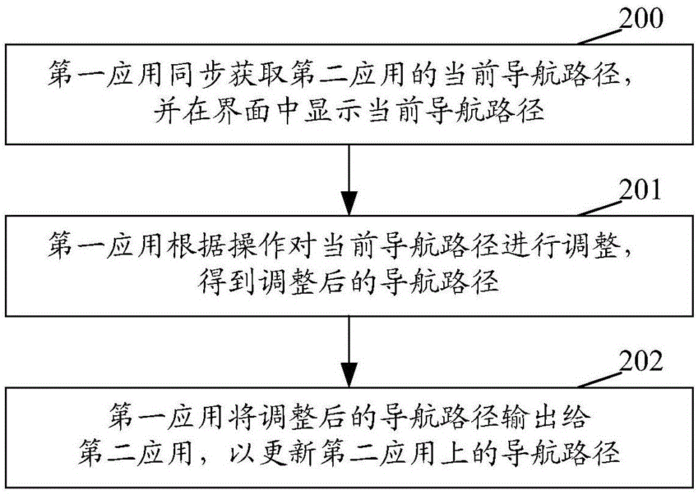
Fig. 2 is a flowchart of a method for implementing navigation according to the present application, as shown in fig. 2, including:
step 200: and the first application synchronously acquires the current navigation information of the second application and displays the current navigation path in the interface.
Optionally, the first application is located in a first terminal and the second application is located in a second terminal.
Optionally, the first terminal is a rider terminal and the second terminal is a driver terminal.
In one implementation mode, the second terminal is a terminal for calculating a navigation path and navigating according to a second application, such as a navigation APP, at a driver end, and the first terminal is a terminal of a passenger but does not make an appointment through a network appointment APP; at this time, the first terminal and the second terminal use the same navigation APP, such as the gold navigation, the Baidu navigation, and the like. Then, this step includes:
a first application, such as a navigation APP, searches for a nearby signal being navigated based on near field communication, such as bluetooth, WiFi, NFC, etc. within the same network;
the first application obtains the searched information from the second application which is navigating, and after the synchronous link code is obtained, the current navigation path is obtained from the second application according to the synchronous link code.
Optionally, the synchronization link code is a string of characters, such as 4-digit numbers, randomly generated by the navigation APP when the second application starts navigation.
Alternatively, the first application may obtain the synchronization link code generated when the second application starts the navigation by receiving the synchronization link code input by the user.
In combination with the scene, under the non-network car reservation scene, a synchronous code is displayed on a navigation interface of a driver terminal, and buttons such as 'search for nearby navigation' are displayed on an interface of a passenger terminal; when the button is triggered, searching surrounding navigation signals; after the navigation signal is searched, the interface of the passenger terminal prompts the user to input the synchronous code, at the moment, the passenger terminal sends a request to the driver terminal according to the synchronous code input by the user, and after the driver terminal receives the correct synchronous code, the information of the current navigation path is sent to the passenger terminal, so that the passenger terminal synchronously obtains the current navigation information of the driver terminal. If the driver terminal receives an incorrect synchronization code, the current navigation path is not transmitted to the passenger terminal.
In another implementation mode, the first terminal is a terminal for booking the car through a network booking APP, and the second terminal is a terminal for calculating a navigation path and navigating according to the navigation APP by the driver side; then, this step includes:
when the first application and the second application are both navigated by adopting a navigation system provided by the network car booking APP, the first application can acquire the operation such as clicking on a synchronous key arranged in the network car booking APP, and synchronously acquire the current navigation information in the second application based on near field communication;
or,
when the second terminal does not adopt the navigation system provided by the network appointment APP to realize navigation, at the moment, the first application and the second application use the same navigation APP, such as Goodpastel navigation and Baidu navigation. Then, this step includes:
the first application searches for a signal which is navigating nearby through a self-navigation APP based on near field communication, such as Bluetooth, WiFi in the same network, NFC and the like;
the first application obtains the searched information from the second application which is navigating, and obtains the current navigation path of the application terminal from the second application according to the synchronous link code after obtaining the synchronous link code.
Step 201: and the first application adjusts the current navigation path according to the operation to obtain the adjusted navigation path.
In the step, the current navigation path is adjusted through the first terminal in the hand of the passenger, so that the passenger can freely zoom the current navigation path, firstly observe whether the advancing route needs to be adjusted or not, whether congestion exists or not and the like, and then reasonably adjust the current navigation path. Moreover, the driving of the driver is not disturbed.
Optionally, the operation may be a click, a drag, and the like on the interface of the first application by the user, and may also trigger the adjustment of the current navigation path obtained synchronously through a gesture, a voice, and the like. The triggering mode is only an example and is not intended to limit the scope of the present application.
Optionally, the adjustment of the current navigation path obtained synchronously may be triggered by clicking a preset edit navigation path button.
Optionally, this step includes:
the first application segments the navigation path, such as segmenting according to the congestion degree of the current navigation path, and determines a changeable intersection node in the current navigation path;
and changing the position of the selected changeable intersection node according to the operation of the user on the changeable intersection node, and recalculating the road section connected with the changeable intersection node after changing. The remaining segments on the current path are unchanged.
By displaying the crowded road section in the current navigation path in a segmented manner in the step, the user can change the intersection node for dragging only by dragging the intersection node of the crowded road section, and the adjustment of the current navigation path can be conveniently realized.
Alternatively, the selectable intersection node selected to be changed may include one or more than one, that is, the navigation path is calculated again after each intersection segment is changed.
Optionally, before selecting a certain changeable intersection node, the method further includes:
and amplifying and displaying the road section where the changeable intersection node needing to be edited is located according to the trigger of the user, such as a gesture and the like, or by selecting a certain road section.
Optionally, before determining the changeable intersection node in the current navigation path, the method further includes:
searching the intersection level sequence of the changeable line of the current leading navigation section in the first application, wherein in a simple way, the larger the intersection is, the more important the intersection is, and the higher the level is; or, the higher the grade of the urban road connected with the intersection is, the higher the grade of the intersection is; the larger the displayed map range is, the higher the level of the displayed changeable intersection node is, and the changeable intersection at the lower level is hidden (similar to the logic of the map for displaying the map details in an enlarged or reduced manner).
Optionally, the step of displaying the navigation path in segments according to the congested road segments of the current navigation path follows:
and acquiring a preset number of crowded road sections from the current navigation path according to the sequence of the crowdedness degrees from high to low, and amplifying and displaying the acquired preset number of crowded road sections in a subsection display area of an interface of a first application, so that a user can operate the displayed crowded road sections to change the current navigation path guide.
Optionally, the segmented display area is used for displaying the determined more than one congested road segments, and the segmented display area may be displayed on the current navigation interface in a form of a drop-down frame, a floating window, or the like, and in the segmented display area, each congested road segment may be displayed in a predetermined number of small areas.
Optionally, the segment display area may be further provided with a scroll bar or scroll to display more congested road segments according to gestures.
For example, the maximum congestion preset number, such as 1 to 5 road segments, is displayed in segments, and the degradation is performed sequentially according to the congestion degree. Such as: if 5 congestion road sections such as a dark red congestion road section (the speed is lower than 20 kilometers per hour) and 3 congestion road sections such as a yellow congestion road section (the speed is 20-40 kilometers per hour) exist in one navigation section, the 5 dark red road sections are displayed firstly; if the dark red congestion road section is less than 5, the remaining yellow slow-moving road sections are displayed.
The minimum display range of the dark red 0-20 segment display area defined according to the base is a segment, and the minimum display range displayed in the segment display area should be the intersection segment in 3 operable intersections.
Through the step, because the congested road section of the current navigation path is automatically segmented, a passenger can observe whether the previous road is congested through global preview, so that the user can quickly and accurately locate a certain congested road section needing to be modified; and the route section needing to be changed is selected by amplifying and reducing the map according to the selection of the user, so that the adjustment of the route is more reasonable.
Step 202: the first application outputs the adjusted navigation path to the second application to update the navigation path on the second application.
In this step, the first application outputs the adjusted navigation path to the second application through the short-distance communication established between the first application and the second application.
The method for realizing navigation is carried out in the navigation process, when re-navigation is needed, re-navigation is simply and flexibly realized, and user experience is improved.
The application also provides a computer-readable storage medium storing computer-executable instructions for executing any one of the above methods for implementing navigation.
A mobile terminal comprising a memory and a processor, wherein the memory has stored therein the following instructions executable by the processor: for performing the steps of any of the above-described methods of implementing navigation.
The method for implementing navigation in the present application is described in detail below with reference to an actual scene.
In this embodiment, a non-net appointment vehicle will be described as an example. In the present embodiment, the behaviors such as car booking and car sharing performed by the non-network car booking APP assume that the same navigation APP is used by both the driver's mobile terminal (referred to as the second terminal in the present embodiment) and the passenger's mobile terminal (referred to as the first terminal in the present embodiment), and the foregoing guidance is taken as an example in the present embodiment. After a passenger gets on the vehicle, the first mobile terminal can acquire a navigation path of the second terminal in navigation through bluetooth, WiFi, NFC and the like in the same network, and the following description is specifically realized:
as shown in fig. 3(a), when the second terminal of the driver navigates using the navigation APP, the navigation APP randomly generates a 4-digit number, such as the synchronization link code "4592" in fig. 3 (a). Also, as shown in fig. 3(a), the current state of the navigation APP is to enlarge and display the current intersection.
When the passenger sits on the passenger seat or the rear seat, the passenger searches for the navigation APP in the proximity enabled navigation through the navigation APP of the first terminal of the passenger, as shown in fig. 3(b), and through the "proximity navigation" search button preset and displayed on the first terminal, the passenger is informed of 1 navigation being used in the vicinity and informed of the terminal being navigated being the "iphone 6plus of xxx" as shown in fig. 3(c) is displayed on the first terminal screen, at this time, if the passenger clicks the navigation widget, the first terminal displays "please input the sync code of the iphone 6plus of xxx" as shown in fig. 3(d), as long as the passenger correctly inputs the sync link code "4592" as shown in fig. 3(a) in the following block, the link success control (icon) is displayed on the navigation APP interface side of the first terminal of the passenger, as shown in fig. 3(e), and simultaneously synchronously displaying the navigation path on the second terminal of the driver.
In this embodiment, if the passenger needs to modify the obtained current navigation path, as shown in fig. 4(a), the current navigation path is adjusted by clicking a "edit path" button that is preset and displayed on the first terminal, at this time:
as shown in fig. 4(b), the navigation APP on the first terminal automatically segments according to the congested road segments in the current navigation and displays the obtained congested road segments in an enlarged manner in the segment display area, so that the passenger can be quickly located to a certain congested road segment to be modified. In this case, the passenger may select a route segment to be changed by enlarging or reducing the map according to his or her selection. When entering the edit path state, as shown in fig. 4(b), according to the operable road segment node based on the intersection of the changeable route, searching the intersection level sequence of the changeable route of the current leading navigation segment, wherein, the more important the intersection is, the higher the level is, the higher the grade of the urban road linked with the intersection is, the higher the grade of the intersection is; the passenger may zoom in by a trigger action such as a gesture, or may zoom in by selecting a congested road segment displayed in a certain segment in fig. 4 (b). Selecting an operable road segment node, changing according to the requirement of the passenger, as shown in fig. 4(c), assuming that the passenger selects one of the changeable nodes, and dragging to the position shown in fig. 4 (d); as shown in fig. 4(e), when there is a position change of a changeable node in the navigation path, the navigation APP recalculates the path of the link connected to the changed node, and the paths of the remaining links are not changed, so that the changed path shown in fig. 4(f) is obtained.
And then, the first terminal outputs the adjusted navigation path to the second terminal, and the second terminal updates the navigation path on the navigation APP of the second terminal according to the obtained updated path.
In practical application of this embodiment, the operable road segment nodes and the selected changeable nodes may be displayed in different colors, for example, the operable road segment nodes are displayed in gray, and the selected changeable nodes are displayed in a highlighted orange color. This is merely an example for distinguishing and not intended to limit the scope of the present application.
The method for achieving navigation is applicable to the scene of taxi taking navigation, and also applicable to the scene that one person rides a bicycle and uses the second terminal for navigation, and the other person sitting on a rear seat uses the first terminal for navigation path updating, and the like.
Fig. 5 is a schematic structural diagram of a device for implementing navigation according to the present application, as shown in fig. 5, including: the device comprises a synchronization module, an adjustment module and an update module; wherein,
the synchronization module is used for synchronously acquiring the current navigation path of the second application and displaying the current navigation path in the second application;
the adjusting module is used for adjusting the current navigation path according to the operation to obtain an adjusted navigation path;
and the updating module is used for outputting the adjusted navigation path to the second application so as to update the navigation path on the second application.
Optionally, when the device for implementing navigation is a terminal of a passenger but does not make an appointment through a network appointment APP, the synchronization module is specifically configured to:
searching for a signal being navigated nearby based on close range communication, such as bluetooth, WiFi within the same network, NFC, etc.;
and obtaining the searched information from the second application which is navigating, and obtaining the current navigation path from the second application according to the synchronous link code after obtaining the synchronous link code.
Optionally, when the device that this application realized navigating is the terminal of car appointment through net car appointment APP, then, synchronization module specifically is used for:
acquiring operation such as clicking on a synchronous key arranged in the online taxi appointment APP, and synchronously acquiring current navigation information in a second application based on short-distance communication; or,
searching for a signal being navigated nearby based on close range communication, such as bluetooth, WiFi within the same network, NFC, etc.; and obtaining the searched information from the second application which is navigating, and obtaining the current navigation path of the application from the second application according to the synchronous link code after obtaining the synchronous link code.
Optionally, the adjusting module is specifically configured to:
when the current navigation path obtained synchronously is triggered to be adjusted according to the operation of a user, segmenting the current navigation path and determining changeable intersection nodes in the current navigation path;
and changing the position of the selected changeable intersection node according to the operation of the user on the changeable intersection node, and recalculating the road section connected with the changeable intersection node after changing. The remaining segments on the current path are unchanged.
Optionally, the adjusting module is further configured to:
and amplifying and displaying the road section where the changeable intersection node needing to be edited is located according to the trigger of the user, such as a gesture and the like, or by selecting a certain road section.
Optionally, the adjusting module is further configured to: and searching the intersection level sequence of the changeable lines of the current pilot segment.
Although the embodiments disclosed in the present application are described above, the descriptions are only for the convenience of understanding the present application, and are not intended to limit the present application. It will be understood by those skilled in the art that various changes in form and details may be made therein without departing from the spirit and scope of the disclosure as defined by the appended claims.