CN110832425B - Control methods, equipment, surveying and mapping drones and spraying drones - Google Patents
Control methods, equipment, surveying and mapping drones and spraying drones Download PDFInfo
- Publication number
- CN110832425B CN110832425B CN201880041489.3A CN201880041489A CN110832425B CN 110832425 B CN110832425 B CN 110832425B CN 201880041489 A CN201880041489 A CN 201880041489A CN 110832425 B CN110832425 B CN 110832425B
- Authority
- CN
- China
- Prior art keywords
- spraying
- information
- drone
- dimensional space
- control information
- Prior art date
- Legal status (The legal status is an assumption and is not a legal conclusion. Google has not performed a legal analysis and makes no representation as to the accuracy of the status listed.)
- Expired - Fee Related
Links
Images


Classifications
-
- G—PHYSICS
- G05—CONTROLLING; REGULATING
- G05D—SYSTEMS FOR CONTROLLING OR REGULATING NON-ELECTRIC VARIABLES
- G05D1/00—Control of position, course, altitude or attitude of land, water, air or space vehicles, e.g. using automatic pilots
- G05D1/08—Control of attitude, i.e. control of roll, pitch, or yaw
- G05D1/0808—Control of attitude, i.e. control of roll, pitch, or yaw specially adapted for aircraft
-
- G—PHYSICS
- G05—CONTROLLING; REGULATING
- G05D—SYSTEMS FOR CONTROLLING OR REGULATING NON-ELECTRIC VARIABLES
- G05D1/00—Control of position, course, altitude or attitude of land, water, air or space vehicles, e.g. using automatic pilots
- G05D1/0094—Control of position, course, altitude or attitude of land, water, air or space vehicles, e.g. using automatic pilots involving pointing a payload, e.g. camera, weapon, sensor, towards a fixed or moving target
-
- A—HUMAN NECESSITIES
- A01—AGRICULTURE; FORESTRY; ANIMAL HUSBANDRY; HUNTING; TRAPPING; FISHING
- A01M—CATCHING, TRAPPING OR SCARING OF ANIMALS; APPARATUS FOR THE DESTRUCTION OF NOXIOUS ANIMALS OR NOXIOUS PLANTS
- A01M7/00—Special adaptations or arrangements of liquid-spraying apparatus for purposes covered by this subclass
- A01M7/0089—Regulating or controlling systems
-
- B—PERFORMING OPERATIONS; TRANSPORTING
- B64—AIRCRAFT; AVIATION; COSMONAUTICS
- B64D—EQUIPMENT FOR FITTING IN OR TO AIRCRAFT; FLIGHT SUITS; PARACHUTES; ARRANGEMENT OR MOUNTING OF POWER PLANTS OR PROPULSION TRANSMISSIONS IN AIRCRAFT
- B64D1/00—Dropping, ejecting, releasing or receiving articles, liquids, or the like, in flight
- B64D1/16—Dropping or releasing powdered, liquid, or gaseous matter, e.g. for fire-fighting
- B64D1/18—Dropping or releasing powdered, liquid, or gaseous matter, e.g. for fire-fighting by spraying, e.g. insecticides
-
- G—PHYSICS
- G05—CONTROLLING; REGULATING
- G05D—SYSTEMS FOR CONTROLLING OR REGULATING NON-ELECTRIC VARIABLES
- G05D1/00—Control of position, course, altitude or attitude of land, water, air or space vehicles, e.g. using automatic pilots
- G05D1/0011—Control of position, course, altitude or attitude of land, water, air or space vehicles, e.g. using automatic pilots associated with a remote control arrangement
- G05D1/0022—Control of position, course, altitude or attitude of land, water, air or space vehicles, e.g. using automatic pilots associated with a remote control arrangement characterised by the communication link
-
- G—PHYSICS
- G05—CONTROLLING; REGULATING
- G05D—SYSTEMS FOR CONTROLLING OR REGULATING NON-ELECTRIC VARIABLES
- G05D1/00—Control of position, course, altitude or attitude of land, water, air or space vehicles, e.g. using automatic pilots
- G05D1/10—Simultaneous control of position or course in three dimensions
- G05D1/101—Simultaneous control of position or course in three dimensions specially adapted for aircraft
- G05D1/106—Change initiated in response to external conditions, e.g. avoidance of elevated terrain or of no-fly zones
-
- G—PHYSICS
- G06—COMPUTING OR CALCULATING; COUNTING
- G06N—COMPUTING ARRANGEMENTS BASED ON SPECIFIC COMPUTATIONAL MODELS
- G06N3/00—Computing arrangements based on biological models
- G06N3/02—Neural networks
-
- G—PHYSICS
- G06—COMPUTING OR CALCULATING; COUNTING
- G06N—COMPUTING ARRANGEMENTS BASED ON SPECIFIC COMPUTATIONAL MODELS
- G06N3/00—Computing arrangements based on biological models
- G06N3/02—Neural networks
- G06N3/04—Architecture, e.g. interconnection topology
- G06N3/0464—Convolutional networks [CNN, ConvNet]
-
- G—PHYSICS
- G06—COMPUTING OR CALCULATING; COUNTING
- G06N—COMPUTING ARRANGEMENTS BASED ON SPECIFIC COMPUTATIONAL MODELS
- G06N3/00—Computing arrangements based on biological models
- G06N3/02—Neural networks
- G06N3/08—Learning methods
-
- G—PHYSICS
- G06—COMPUTING OR CALCULATING; COUNTING
- G06V—IMAGE OR VIDEO RECOGNITION OR UNDERSTANDING
- G06V20/00—Scenes; Scene-specific elements
- G06V20/10—Terrestrial scenes
- G06V20/188—Vegetation
-
- B—PERFORMING OPERATIONS; TRANSPORTING
- B64—AIRCRAFT; AVIATION; COSMONAUTICS
- B64U—UNMANNED AERIAL VEHICLES [UAV]; EQUIPMENT THEREFOR
- B64U10/00—Type of UAV
- B64U10/10—Rotorcrafts
- B64U10/13—Flying platforms
-
- B—PERFORMING OPERATIONS; TRANSPORTING
- B64—AIRCRAFT; AVIATION; COSMONAUTICS
- B64U—UNMANNED AERIAL VEHICLES [UAV]; EQUIPMENT THEREFOR
- B64U2101/00—UAVs specially adapted for particular uses or applications
- B64U2101/30—UAVs specially adapted for particular uses or applications for imaging, photography or videography
- B64U2101/31—UAVs specially adapted for particular uses or applications for imaging, photography or videography for surveillance
-
- B—PERFORMING OPERATIONS; TRANSPORTING
- B64—AIRCRAFT; AVIATION; COSMONAUTICS
- B64U—UNMANNED AERIAL VEHICLES [UAV]; EQUIPMENT THEREFOR
- B64U2101/00—UAVs specially adapted for particular uses or applications
- B64U2101/40—UAVs specially adapted for particular uses or applications for agriculture or forestry operations
-
- B—PERFORMING OPERATIONS; TRANSPORTING
- B64—AIRCRAFT; AVIATION; COSMONAUTICS
- B64U—UNMANNED AERIAL VEHICLES [UAV]; EQUIPMENT THEREFOR
- B64U2101/00—UAVs specially adapted for particular uses or applications
- B64U2101/45—UAVs specially adapted for particular uses or applications for releasing liquids or powders in-flight, e.g. crop-dusting
-
- B—PERFORMING OPERATIONS; TRANSPORTING
- B64—AIRCRAFT; AVIATION; COSMONAUTICS
- B64U—UNMANNED AERIAL VEHICLES [UAV]; EQUIPMENT THEREFOR
- B64U2201/00—UAVs characterised by their flight controls
-
- B—PERFORMING OPERATIONS; TRANSPORTING
- B64—AIRCRAFT; AVIATION; COSMONAUTICS
- B64U—UNMANNED AERIAL VEHICLES [UAV]; EQUIPMENT THEREFOR
- B64U2201/00—UAVs characterised by their flight controls
- B64U2201/10—UAVs characterised by their flight controls autonomous, i.e. by navigating independently from ground or air stations, e.g. by using inertial navigation systems [INS]
-
- B—PERFORMING OPERATIONS; TRANSPORTING
- B64—AIRCRAFT; AVIATION; COSMONAUTICS
- B64U—UNMANNED AERIAL VEHICLES [UAV]; EQUIPMENT THEREFOR
- B64U2201/00—UAVs characterised by their flight controls
- B64U2201/20—Remote controls
Landscapes
- Engineering & Computer Science (AREA)
- Physics & Mathematics (AREA)
- General Physics & Mathematics (AREA)
- Theoretical Computer Science (AREA)
- Aviation & Aerospace Engineering (AREA)
- Life Sciences & Earth Sciences (AREA)
- Automation & Control Theory (AREA)
- Remote Sensing (AREA)
- Radar, Positioning & Navigation (AREA)
- Health & Medical Sciences (AREA)
- General Health & Medical Sciences (AREA)
- Computational Linguistics (AREA)
- Biophysics (AREA)
- General Engineering & Computer Science (AREA)
- Molecular Biology (AREA)
- Mathematical Physics (AREA)
- Software Systems (AREA)
- Evolutionary Computation (AREA)
- Pest Control & Pesticides (AREA)
- Data Mining & Analysis (AREA)
- Computing Systems (AREA)
- Artificial Intelligence (AREA)
- Biomedical Technology (AREA)
- Multimedia (AREA)
- Environmental Sciences (AREA)
- Zoology (AREA)
- Wood Science & Technology (AREA)
- Insects & Arthropods (AREA)
- Control Of Position, Course, Altitude, Or Attitude Of Moving Bodies (AREA)
- Catching Or Destruction (AREA)
- Management, Administration, Business Operations System, And Electronic Commerce (AREA)
Abstract
本发明实施例提供一种控制方法、设备、测绘无人机和喷洒无人机,此方法包括:测绘无人机在目标作物区域飞行的过程中,获取拍摄装置输出的图像,根据图像获取目标作物区域的三维空间信息。喷洒控制信息确定设备获取三维空间信息,根据三维空间信息确定喷洒控制信息,喷洒控制信息包括喷洒无人机在对目标作物区域中种植的每一株目标作物喷洒时的喷洒模式;喷洒模式包括飞行模式。喷洒无人机获取喷洒控制信息,根据每一株目标作物的喷洒模式控制喷洒无人机对对应的目标作物进行喷洒。减少了喷洒无人机的喷洒时间,保证时间成本,提高喷洒效率,保证针对不同目标作物具有很好的喷洒效果,提高喷洒无人机喷洒作业的智能化程度和便利性。
Embodiments of the present invention provide a control method, equipment, a surveying and mapping drone, and a spraying drone. The method includes: during the flight of the surveying and mapping drone in a target crop area, acquiring an image output by a photographing device, and acquiring a target according to the image 3D spatial information of the crop area. The spraying control information determination device obtains three-dimensional space information, and determines spraying control information according to the three-dimensional space information. The spraying control information includes the spraying mode of the spraying drone when spraying each target crop planted in the target crop area; the spraying mode includes flying model. The spraying drone obtains spraying control information, and controls the spraying drone to spray the corresponding target crops according to the spraying mode of each target crop. It reduces the spraying time of the spraying drone, guarantees the time cost, improves the spraying efficiency, ensures a good spraying effect for different target crops, and improves the intelligence and convenience of the spraying operation of the spraying drone.
Description
技术领域technical field
本发明实施例涉及无人机技术领域,尤其涉及一种控制方法、设备、测绘无人机和喷洒无人机。The embodiments of the present invention relate to the technical field of unmanned aerial vehicles, and in particular, to a control method, equipment, a surveying and mapping unmanned aerial vehicle, and a spraying unmanned aerial vehicle.
背景技术Background technique
随着消费级无人机日益普及,行业级应用无人机也开始崭露头角,对为农行业来说,农业无人机作为行业级应用无人机占据着重要的位置,其可以对农田地进行植保作业,例如喷洒作业(喷洒水分、农药、种子等等),给农业领域带来了极大的便利,例如节省用户时间、提高作业效率、增加作业收益以及提高农业机械的利用效率等。With the increasing popularity of consumer drones, industry-level application drones have also begun to emerge. For the agricultural industry, agricultural drones occupy an important position as industry-level application drones. Plant protection operations, such as spraying operations (spraying water, pesticides, seeds, etc.), have brought great convenience to the agricultural field, such as saving user time, improving operation efficiency, increasing operation revenue, and improving the utilization efficiency of agricultural machinery.
然而,现有的喷洒作业方式智能化程度不高,不够便利,例如,以稀疏种植的目标作物(例如果树)为例,现有技术中,需要手动地标记每一株目标作物的位置,然后控制喷洒无人机对每一株目标作物进行喷洒。一方面,这种手动标记的方式效率很低,另一方便,手动标记的方式可能由于某些原因(例如目标作物较高等)不太容易实现。However, the existing spraying operation methods are not highly intelligent and not convenient enough. For example, taking sparsely planted target crops (such as fruit trees) as an example, in the prior art, the position of each target crop needs to be manually marked, and then Control the spraying drone to spray each target crop. On the one hand, this manual marking method is inefficient, and on the other hand, it is convenient, and the manual marking method may not be easy to implement for some reasons (for example, the target crops are higher, etc.).
发明内容SUMMARY OF THE INVENTION
本发明实施例提供一种控制方法、设备、测绘无人机和喷洒无人机,以提高喷洒无人机喷洒作业的智能化程度和便利性。The embodiments of the present invention provide a control method, equipment, a surveying and mapping drone, and a spraying drone, so as to improve the intelligence and convenience of the spraying operation of the spraying drone.
第一方面,本发明实施例提供的一种控制方法,用于测绘无人机,其中,测绘无人机上配置拍摄装置,所述方法包括:In a first aspect, an embodiment of the present invention provides a control method for a surveying and mapping drone, wherein a photographing device is configured on the surveying and mapping drone, and the method includes:
在测绘无人机在目标作物区域飞行的过程中,获取拍摄装置输出的图像,其中,所述目标作物区域中种植多株目标作物;During the flight of the surveying and mapping drone in the target crop area, an image output by the photographing device is acquired, wherein a plurality of target crops are planted in the target crop area;
根据所述图像获取目标作物区域的三维空间信息,其中,所述目标作物区域的三维空间信息用于确定喷洒无人机对所述多株目标作物进行喷洒的喷洒控制信息;Acquire three-dimensional space information of the target crop area according to the image, wherein the three-dimensional space information of the target crop area is used to determine spraying control information for spraying the multiple target crops by the spraying drone;
所述喷洒控制信息包括喷洒无人机在对多株目标作物中每一株目标作物喷洒时的喷洒模式;所述喷洒模式包括飞行模式。The spraying control information includes a spraying mode when the spraying drone sprays each target crop among the multiple target crops; the spraying mode includes a flight mode.
第二方面,本发明实施例提供的一种控制方法,应用于喷洒控制信息确定设备,所述方法包括:In a second aspect, a control method provided by an embodiment of the present invention is applied to a device for determining spraying control information, and the method includes:
获取目标作物区域的三维空间信息,其中,所述目标作物区域中种植多株目标作物;obtaining three-dimensional space information of a target crop area, wherein multiple target crops are planted in the target crop area;
根据所述三维空间信息确定喷洒控制信息,其中,所述喷洒控制信息用于控制喷洒无人机对所述多株目标作物的喷洒;Determine spraying control information according to the three-dimensional space information, wherein the spraying control information is used to control the spraying of the multiple target crops by the spraying drone;
所述喷洒控制信息包括喷洒无人机在对多株目标作物中每一株目标作物喷洒时的喷洒模式;所述喷洒模式包括飞行模式。The spraying control information includes a spraying mode when the spraying drone sprays each target crop among the multiple target crops; the spraying mode includes a flight mode.
第三方面,本发明实施例提供的一种喷洒无人机的控制方法,包括:In a third aspect, a method for controlling a spraying drone provided by an embodiment of the present invention includes:
获取对目标作物区域中种植的多株目标作物进行喷洒的喷洒控制信息,其中,所述目标作物区域中种植多株目标作物,所述喷洒控制信息是根据所述目标作物区域的三维空间信息确定的;所述喷洒控制信息包括喷洒无人机在对多株目标作物中每一株目标作物喷洒时的喷洒模式;所述喷洒模式包括飞行模式;Obtain spraying control information for spraying multiple target crops planted in the target crop area, wherein multiple target crops are planted in the target crop area, and the spraying control information is determined according to the three-dimensional space information of the target crop area The spraying control information includes the spraying mode of the spraying drone when spraying each target crop among the multiple target crops; the spraying mode includes the flight mode;
根据所述每一株目标作物的喷洒模式控制喷洒无人机对对应的目标作物进行喷洒。The spraying drone is controlled to spray the corresponding target crops according to the spraying mode of each target crop.
第四方面,本发明实施例提供的一种测绘无人机,包括:拍摄装置和处理器;In a fourth aspect, a surveying and mapping drone provided by an embodiment of the present invention includes: a photographing device and a processor;
所述拍摄装置,用于采集图像;the photographing device for collecting images;
所述处理器,用于在所述测绘无人机在目标作物区域飞行的过程中,获取所述拍摄装置输出的图像,其中,所述目标作物区域中种植多株目标作物;并根据所述图像获取目标作物区域的三维空间信息,其中,所述目标作物区域的三维空间信息用于确定喷洒无人机对所述多株目标作物进行喷洒的喷洒控制信息;The processor is configured to acquire the image output by the photographing device during the flight of the surveying and mapping drone in the target crop area, wherein a plurality of target crops are planted in the target crop area; and according to the The three-dimensional space information of the target crop area is obtained from the image, wherein the three-dimensional space information of the target crop area is used to determine the spraying control information for spraying the multiple target crops by the spraying drone;
所述喷洒控制信息包括喷洒无人机在对多株目标作物中每一株目标作物喷洒时的喷洒模式;所述喷洒模式包括飞行模式。The spraying control information includes a spraying mode when the spraying drone sprays each target crop among the multiple target crops; the spraying mode includes a flight mode.
第五方面,本发明实施例提供的一种喷洒控制信息确定设备,包括:存储器和处理器;In a fifth aspect, a device for determining spraying control information provided by an embodiment of the present invention includes: a memory and a processor;
所述存储器,用于存储程序代码;the memory for storing program codes;
所述处理器,调用所述程序代码,当程序代码被执行时,用于:The processor calls the program code, when the program code is executed, for:
获取目标作物区域的三维空间信息,其中,所述目标作物区域中种植多株目标作物;obtaining three-dimensional space information of a target crop area, wherein multiple target crops are planted in the target crop area;
根据所述三维空间信息确定喷洒控制信息,其中,所述喷洒控制信息用于控制喷洒无人机对所述多株目标作物的喷洒;Determine spraying control information according to the three-dimensional space information, wherein the spraying control information is used to control the spraying of the multiple target crops by the spraying drone;
所述喷洒控制信息包括喷洒无人机在对多株目标作物中每一株目标作物喷洒时的喷洒模式;所述喷洒模式包括飞行模式。The spraying control information includes a spraying mode when the spraying drone sprays each target crop among the multiple target crops; the spraying mode includes a flight mode.
第六方面,本发明实施例提供一种喷洒无人机,包括:存储器和处理器;In a sixth aspect, an embodiment of the present invention provides a spraying drone, including: a memory and a processor;
所述存储器,用于存储程序代码;the memory for storing program codes;
所述处理器,调用所述程序代码,当程序代码被执行时,用于:The processor calls the program code, when the program code is executed, for:
获取对目标作物区域中种植的多株目标作物进行喷洒的喷洒控制信息,其中,所述目标作物区域中种植多株目标作物,所述喷洒控制信息是根据所述目标作物区域的三维空间信息确定的;所述喷洒控制信息包括喷洒无人机在对多株目标作物中每一株目标作物喷洒时的喷洒模式;所述喷洒模式包括飞行模式;Obtain spraying control information for spraying multiple target crops planted in the target crop area, wherein multiple target crops are planted in the target crop area, and the spraying control information is determined according to the three-dimensional space information of the target crop area The spraying control information includes the spraying mode of the spraying drone when spraying each target crop among the multiple target crops; the spraying mode includes the flight mode;
根据所述每一株目标作物的喷洒模式控制喷洒无人机对对应的目标作物进行喷洒。The spraying drone is controlled to spray the corresponding target crops according to the spraying mode of each target crop.
第七方面,本发明实施例提供一种计算机可读存储介质,所述计算机可读存储介质存储有计算机程序,所述计算机程序包含至少一段代码,所述至少一段代码可由计算机执行,以控制所述计算机执行第一方面或第二方面或第三方面本发明实施例所述的控制方法。In a seventh aspect, an embodiment of the present invention provides a computer-readable storage medium, where a computer program is stored in the computer-readable storage medium, and the computer program includes at least one piece of code, and the at least one piece of code can be executed by a computer to control the The computer executes the control method described in the embodiments of the present invention in the first aspect or the second aspect or the third aspect.
第八方面,本发明实施例提供一种计算机程序,当所述计算机程序被计算机执行时,用于实现第一方面或第二方面或第三方面本发明实施例所述的控制方法。In an eighth aspect, an embodiment of the present invention provides a computer program, which, when the computer program is executed by a computer, is used to implement the control method described in the embodiment of the present invention in the first aspect or the second aspect or the third aspect.
本发明实施例提供的控制方法、设备、测绘无人机和喷洒无人机,通过测绘无人机在目标作物区域飞行的过程中,获取拍摄装置输出的图像,其中,所述目标作物区域中种植多株目标作物,然后根据所述图像获取目标作物区域的三维空间信息。再由喷洒控制信息确定设备获取所述三维空间信息,并根据所述三维空间信息确定喷洒无人机对所述多株目标作物的喷洒控制信息,所述喷洒控制信息包括喷洒无人机在对多株目标作物中每一株目标作物喷洒时的喷洒模式;所述喷洒模式包括飞行模式。喷洒无人机获取所述喷洒控制信息,然后根据所述每一株目标作物的喷洒模式控制喷洒无人机对对应的目标作物进行喷洒。由于喷洒控制信息是根据目标作物区域的三维空间信息确定的,可以减少喷洒无人机的喷洒时间,保证时间成本,提高喷洒效率;同时,可以保证针对不同目标作物具有很好的喷洒效果,提高了喷洒无人机喷洒作业的智能化程度和便利性。In the control method, device, surveying and mapping drone, and spraying drone provided by the embodiments of the present invention, the image output by the photographing device is acquired during the flight of the surveying and mapping drone in the target crop area, wherein the target crop area is Plant multiple target crops, and then obtain three-dimensional spatial information of the target crop area according to the image. Then, the three-dimensional space information is obtained by the spraying control information determination device, and the spraying control information of the spraying drone on the multiple target crops is determined according to the three-dimensional space information, and the spraying control information includes the spraying drone is on the target crops. The spraying mode when each target crop of the multiple target crops is sprayed; the spraying mode includes a flight mode. The spraying drone obtains the spraying control information, and then controls the spraying drone to spray the corresponding target crops according to the spraying mode of each target crop. Since the spraying control information is determined according to the three-dimensional space information of the target crop area, the spraying time of the spraying drone can be reduced, the time cost can be guaranteed, and the spraying efficiency can be improved; It improves the intelligence and convenience of the spraying drone spraying operation.
附图说明Description of drawings
为了更清楚地说明本发明实施例或现有技术中的技术方案,下面将对实施例或现有技术描述中所需要使用的附图作一简单地介绍,显而易见地,下面描述中的附图是本发明的一些实施例,对于本领域普通技术人员来讲,在不付出创造性劳动的前提下,还可以根据这些附图获得其他的附图。In order to more clearly illustrate the embodiments of the present invention or the technical solutions in the prior art, the following briefly introduces the accompanying drawings that need to be used in the description of the embodiments or the prior art. Obviously, the accompanying drawings in the following description These are some embodiments of the present invention. For those of ordinary skill in the art, other drawings can also be obtained according to these drawings without creative efforts.
图1为本发明实施例提供的测绘无人机对目标作物区域进行测绘的示意图;Fig. 1 is the schematic diagram that the surveying and mapping drone provided by the embodiment of the present invention surveys and maps the target crop area;
图2为本发明实施例提供的应用场景示意图;2 is a schematic diagram of an application scenario provided by an embodiment of the present invention;
图3为本发明实施例提供的喷洒无人机对目标作物区域中的多株目标作物进行喷洒的示意图;3 is a schematic diagram of spraying a plurality of target crops in a target crop area by a spraying drone provided by an embodiment of the present invention;
图4为本发明一实施例提供的控制方法的流程图;4 is a flowchart of a control method provided by an embodiment of the present invention;
图5为本发明一实施例提供的喷洒无人机旋转机身飞行的一种示意图;FIG. 5 is a schematic diagram of the flying of the rotating body of the spraying drone according to an embodiment of the present invention;
图6为本发明一实施例提供的喷洒无人机上下往复飞行的一种示意图;6 is a schematic diagram of the up and down reciprocating flight of a spray drone provided by an embodiment of the present invention;
图7为本发明一实施例提供的喷洒无人机螺旋式飞行的一种示意图;FIG. 7 is a schematic diagram of the helical flight of the spray drone provided by an embodiment of the present invention;
图8为本发明一实施例提供的喷洒无人机水平环绕飞行的一种示意图;FIG. 8 is a schematic diagram of a spraying drone flying around horizontally according to an embodiment of the present invention;
图9为本发明实施例提供的测绘无人机的一种结构示意图;9 is a schematic structural diagram of a surveying and mapping unmanned aerial vehicle provided by an embodiment of the present invention;
图10为本发明实施例提供的喷洒控制信息确定设备的一种结构示意图;10 is a schematic structural diagram of a device for determining spraying control information provided by an embodiment of the present invention;
图11为本发明实施例提供的喷洒无人机的一种结构示意图;11 is a schematic structural diagram of a spraying drone provided by an embodiment of the present invention;
图12为本发明实施例提供的控制系统的一种结构示意图。FIG. 12 is a schematic structural diagram of a control system provided by an embodiment of the present invention.
具体实施方式Detailed ways
为使本发明实施例的目的、技术方案和优点更加清楚,下面将结合本发明实施例中的附图,对本发明实施例中的技术方案进行清楚、完整地描述,显然,所描述的实施例是本发明一部分实施例,而不是全部的实施例。基于本发明中的实施例,本领域普通技术人员在没有作出创造性劳动前提下所获得的所有其他实施例,都属于本发明保护的范围。In order to make the purposes, technical solutions and advantages of the embodiments of the present invention clearer, the technical solutions in the embodiments of the present invention will be clearly and completely described below with reference to the accompanying drawings in the embodiments of the present invention. Obviously, the described embodiments These are some embodiments of the present invention, but not all embodiments. Based on the embodiments of the present invention, all other embodiments obtained by those of ordinary skill in the art without creative efforts shall fall within the protection scope of the present invention.
需要说明的是,当组件被称为“固定于”另一个组件,它可以直接在另一个组件上或者也可以存在居中的组件。当一个组件被认为是“连接”另一个组件,它可以是直接连接到另一个组件或者可能同时存在居中组件。It should be noted that when a component is referred to as being "fixed to" another component, it can be directly on the other component or there may also be a centered component. When a component is considered to be "connected" to another component, it may be directly connected to the other component or there may be a co-existence of an intervening component.
除非另有定义,本文所使用的所有的技术和科学术语与属于本发明的技术领域的技术人员通常理解的含义相同。本文中在本发明的说明书中所使用的术语只是为了描述具体的实施例的目的,不是旨在于限制本发明。本文所使用的术语“及/或”包括一个或多个相关的所列项目的任意的和所有的组合。Unless otherwise defined, all technical and scientific terms used herein have the same meaning as commonly understood by one of ordinary skill in the art to which this invention belongs. The terms used herein in the description of the present invention are for the purpose of describing specific embodiments only, and are not intended to limit the present invention. As used herein, the term "and/or" includes any and all combinations of one or more of the associated listed items.
本发明实施例提供的一种控制方法、设备、测绘无人机和喷洒无人机,可以应用于喷洒无人机对作物区域中的多株目标作物进行喷洒控制的场景。图1为本发明实施例提供的测绘无人机对目标作物区域进行测绘的示意图,如图1所示,测绘无人机101对目标作物区域上飞行,利用测绘无人机101配置的拍摄装置对目标作物区域进行拍摄。其中,目标作物区域中种植多株目标作物,在某些情况中,目标作物区域中稀疏地种植多株目标作物,该目标作物可以是任何农业作物,进一步地,所述目标作物可以包括树木,更进一步地,所述树木可以包括果树、茶树、橡胶树等等,但本发明各实施例并不限于此。图2为本发明实施例提供的应用场景示意图,如图2所示,图2中示出了测绘无人机101、喷洒控制信息确定设备102、喷洒无人机103和地面控制终端104。喷洒控制信息确定设备102为任何可以根据如前所述的目标作物区域的三维空间信息确定喷洒控制信息的设备,例如,所述喷洒控制信息确定设备102可以包括遥控器、智能手机、台式电脑、膝上型电脑、服务器、穿戴式设备(手表、手环)中的一种或多种,本发明实施例以喷洒控制信息确定设备102为电脑来进行示意性说明。喷洒无人机103的地面控制终端104可以是遥控器、智能手机、台式电脑、膝上型电脑、穿戴式设备(手表、手环)中的一种或多种。本发明实施例以地面控制终端104为摇控器1041和终端设备1042为例来进行示意性说明。该终端设备1042例如是智能手机、可穿戴设备、平板电脑等,但本发明实施例并限于此。The control method, device, surveying and mapping drone, and spraying drone provided by the embodiments of the present invention can be applied to a scene where the spraying drone performs spraying control on multiple target crops in a crop area. FIG. 1 is a schematic diagram of a surveying and mapping drone for surveying and mapping a target crop area provided by an embodiment of the present invention. As shown in FIG. 1 , the surveying and
其中,测绘无人机101可以获取拍摄装置输出的图像,并根据所述图像获取目标作物区域的三维空间信息,其中,所述目标作物区域的三维空间信息用于确定喷洒无人机对所述多株目标作物进行喷洒的喷洒控制信息。喷洒控制信息确定设备102可以通过直接或者间接、有线通信或者无线通信的方式从所述测绘无人机101获取所述目标作物区域的三维空间信息,并根据所述三维空间信息确定喷洒控制信息,其中,所述喷洒控制信息用于控制喷洒无人机103对目标作物区域内的所述多株目标作物的喷洒。在某些情况中,喷洒控制信息确定设备102可以从除测绘无人机101以外的其他途径获取目标作物区域的三维空间信息。喷洒无人机103可以通过直接或者间接、有线通信或者无线通信的方式从喷洒控制信息确定设备102获取所述喷洒控制信息,并根据所述喷洒控制信息,对目标作物区域中的每一株目标作物进行喷洒控制。在某些实施例中,喷洒控制信息确定设备102可以将喷洒控制信息发送给喷洒无人机103的地面控制终端104,由喷洒无人机103的地面控制终端104根据用于控制喷洒无人机103进行喷洒操作的信息,控制喷洒无人机103对目标作物区域进行喷洒控制。在某些实施例中,喷洒控制信息确定设备102可以将所述喷洒控制信息发送给喷洒无人机103,喷洒无人机103可以根据所述喷洒控制信息对目标作业区域中的每一株目标作物进行喷洒,如图3所示。Wherein, the surveying and
下面结合附图,对本发明的一些实施方式作详细说明。在不冲突的情况下,下述的实施例及实施例中的特征可以相互组合。Some embodiments of the present invention will be described in detail below with reference to the accompanying drawings. The embodiments described below and features in the embodiments may be combined with each other without conflict.
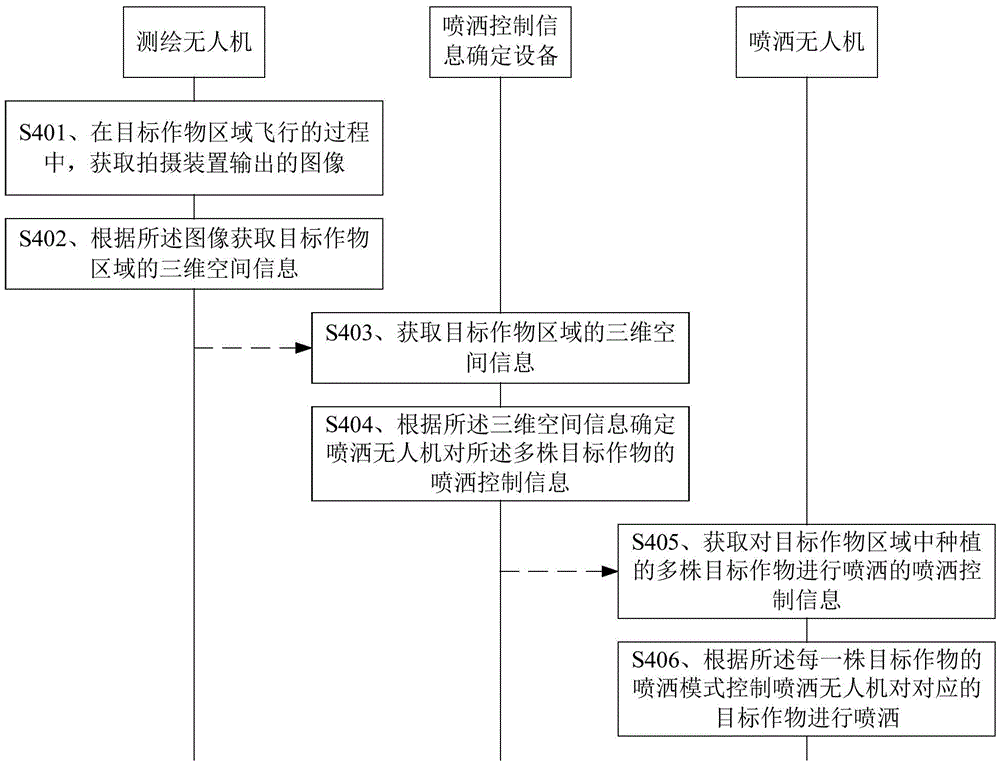
图4为本发明一实施例提供的控制方法的流程图,如图4所示,本实施例的方法可以包括:FIG. 4 is a flowchart of a control method provided by an embodiment of the present invention. As shown in FIG. 4 , the method of this embodiment may include:
S401、测绘无人机在目标作物区域飞行的过程中,获取拍摄装置输出的图像。S401 , during the flight of the surveying and mapping drone in the target crop area, acquire an image output by the photographing device.
本实施例中,测绘无人机上配置有拍摄装置,测绘无人机在目标作物区域飞行的过程中,测绘无人机上配置的拍摄装置可以对目标作物区域进行拍摄,从而获得拍摄装置输出的图像。其中,测绘无人机可以按照预先规划的航线在目标作物区域内飞行。其中,该拍摄装置可以是在测绘无人机飞行时,等间距拍摄或者等时间拍摄。In this embodiment, a photographing device is configured on the surveying and mapping drone. During the flight of the surveying and mapping drone in the target crop area, the photographing device configured on the surveying and mapping drone can photograph the target crop area, so as to obtain the image output by the photographing device. . Among them, the surveying and mapping drone can fly in the target crop area according to the pre-planned route. Wherein, the photographing device may be equidistant photographing or equidistant photographing when the surveying and mapping drone is flying.
该目标作物区域中种植多株目标作物。可选地,该目标作物例如为树木,可选地,该树木例如为果树。本实施例的目标作物并不限于此。Plant multiple target crops in the target crop area. Optionally, the target crop is, for example, a tree, optionally, the tree is, for example, a fruit tree. The target crop of this embodiment is not limited to this.
S402、测绘无人机根据所述图像获取目标作物区域的三维空间信息。S402, the surveying and mapping drone acquires three-dimensional spatial information of the target crop area according to the image.
本实施例中,测绘无人机可以根据拍摄装置输出的图像获取该目标作物区域的三维空间信息。该目标作物区域的三维空间信息用于确定喷洒无人机对所述多株目标作物进行喷洒的喷洒控制信息。In this embodiment, the surveying and mapping drone can acquire the three-dimensional space information of the target crop area according to the image output by the photographing device. The three-dimensional space information of the target crop area is used to determine spraying control information for spraying the multiple target crops by the spraying drone.
在一些实施例中,在喷洒无人机在目标作物区域飞行的过程中,还获取测绘无人机的位置信息和拍摄装置的姿态。相应地,上述S402的一种可能的实现方式为:喷洒无人机根据所述图像、所述位置信息和所述姿态获取目标作物区域的三维空间信息。其中,在某些情况中,所述位置信息是由测绘无人机上的实时动态(Real-time kinematic,RTK)定位设备提供的,因此,据此获得的三维空间信息更加准确。In some embodiments, during the flying of the spraying drone in the target crop area, the location information of the surveying and mapping drone and the attitude of the photographing device are also acquired. Correspondingly, a possible implementation manner of the above S402 is: the spraying drone acquires the three-dimensional space information of the target crop area according to the image, the position information and the attitude. Wherein, in some cases, the position information is provided by a real-time kinematic (RTK) positioning device on the surveying and mapping drone, so the three-dimensional space information obtained therefrom is more accurate.
在一些实施例中,所述测绘无人机还配置雷达设备,其中,所述雷达设备包括毫米波雷达或者激光雷达,测绘无人机在目标作物区域飞行的过程中,获取雷达设备输出的第一三维空间信息,其中,所述测绘无人机根据所述图像获取目标作物区域的三维空间信息包括:利用所述图像重建目标作物区域的第二三维空间信息,利用第一三维空间信息对第二三维空间信息进行校准以获取所述目标作物区域的三维空间信息。由于拍摄装置在对目标作物区域进行拍摄时,图像的质量受光照影响较大,例如,当拍摄装置逆光拍摄时,拍摄获取的图像就会不清晰,导致根据图像重建的三维空间信息会不准确,因此,可以通过第一三空间信息对第二三维空间信息进行校准,可以提高获得的目标区域的三维空间信息的准确率。In some embodiments, the surveying and mapping drone is further configured with a radar device, wherein the radar device includes a millimeter-wave radar or a lidar. During the flight of the surveying and mapping drone in the target crop area, the first output of the radar device is obtained. A three-dimensional space information, wherein obtaining the three-dimensional space information of the target crop area by the surveying and mapping drone according to the image includes: reconstructing the second three-dimensional space information of the target crop area by using the image, and using the first three-dimensional space information to reconstruct the first three-dimensional space information. The two- and three-dimensional spatial information is calibrated to obtain the three-dimensional spatial information of the target crop area. When the photographing device shoots the target crop area, the quality of the image is greatly affected by the illumination. For example, when the photographing device shoots against the light, the captured image will be unclear, resulting in inaccurate three-dimensional spatial information reconstructed from the image. , therefore, the second three-dimensional space information can be calibrated by the first three-dimensional space information, and the accuracy of the obtained three-dimensional space information of the target area can be improved.
S403、喷洒控制信息确定设备获取目标作物区域的三维空间信息。S403 , the spraying control information determining device acquires three-dimensional spatial information of the target crop area.
本实施例中,喷洒控制信息确定设备可以获取目标作物区域的三维空间信息。可选地,所述三维空间信息是测绘无人机在目标作物区域内飞行时根据拍摄装置输出的图像确定的,具体可以参见上述S401-S402所述,此处不再赘述。在某些情况下,所述目标作物区域的三维空间信息可以从除测绘无人机以外的其他方式获取,在此不做具体的限定。In this embodiment, the spraying control information determining device can acquire the three-dimensional space information of the target crop area. Optionally, the three-dimensional space information is determined according to the image output by the photographing device when the surveying and mapping drone flies in the target crop area. For details, refer to the descriptions in the above S401-S402, which will not be repeated here. In some cases, the three-dimensional space information of the target crop area may be obtained from other means than the surveying and mapping drone, which is not specifically limited here.
在一些实施例中,测绘无人机与喷洒控制信息确定设备可以通过有线通信连接或无线通信连接通信。测绘无人机在执行上述S402之后,还将目标作物区域的三维空间信息通过无线通信连接或者有线通信连接发送给喷洒控制信息确定设备。相应地,S403的一种可能的实现方式为:喷洒控制信息确定设备通过无线通信连接或者有线通信连接接收所述测绘无人机发送的上述三维空间信息。其中,所述有线通信连接或无线通信连接通信可以为直接地通信,即点对点的通信,也可以为间接通信,即通过中间设备(例如测绘无人机的地面控制端)来进行通信。In some embodiments, the mapping drone and the spray control information determination device may communicate through a wired communication connection or a wireless communication connection. After performing the above S402, the surveying and mapping drone also sends the three-dimensional space information of the target crop area to the spraying control information determining device through a wireless communication connection or a wired communication connection. Correspondingly, a possible implementation manner of S403 is: the spraying control information determination device receives the above-mentioned three-dimensional space information sent by the surveying and mapping drone through a wireless communication connection or a wired communication connection. The wired communication connection or wireless communication connection communication may be direct communication, that is, point-to-point communication, or indirect communication, that is, communication through an intermediate device (eg, the ground control terminal of a surveying and mapping drone).
在另一些实施例中,测绘无人机在执行上述S402之后,将所述三维空间信息存储到存储设备中。相应地,S403的一种可能的实现方式为:喷洒控制信息确定从存储设备中获取所述三维空间信息。该存储设备例如为安全数码卡(Secure Digital Memory Card,SD卡),本实施例并不限于此,测绘无人机可以将获得的三维空间信息存储在SD卡中,然后用户将SD卡从测绘无人机上拔出并插入至喷洒控制信息确定设备中,喷洒控制信息确定设备从插入其中的SD卡中获取三维空间信息。In other embodiments, after performing the above S402, the surveying and mapping drone stores the three-dimensional space information in a storage device. Correspondingly, a possible implementation manner of S403 is: determining the spray control information to obtain the three-dimensional space information from a storage device. The storage device is, for example, a Secure Digital Memory Card (SD card). This embodiment is not limited to this. The surveying and mapping drone can store the acquired three-dimensional space information in the SD card. The drone is pulled out and inserted into the spraying control information determining device, and the spraying control information determining device obtains three-dimensional space information from the SD card inserted into it.
S404、喷洒控制信息确定设备根据所述三维空间信息确定喷洒无人机对所述多株目标作物的喷洒控制信息。S404. The spraying control information determining device determines spraying control information of the multiple target crops by the spraying drone according to the three-dimensional space information.
本实施例中,喷洒控制信息确定设备在获取到目标作物区域的三维空间信息后,根据该三维空间信息确定喷洒无人机对该目标作物区域内种植的多株目标作物的喷洒控制信息,其中,所述喷洒控制信息用于控制喷洒无人机对所述多株目标作物的喷洒。所述喷洒控制信息包括喷洒无人机在对多株目标作物中每一株目标作物喷洒时的喷洒模式,所述喷洒模式还包括飞行模式。In this embodiment, after obtaining the three-dimensional space information of the target crop area, the spraying control information determining device determines the spraying control information of the spraying drone for multiple target crops planted in the target crop area according to the three-dimensional space information, wherein , the spraying control information is used to control the spraying of the multiple target crops by the spraying drone. The spraying control information includes a spraying mode of the spraying drone when spraying each target crop among the multiple target crops, and the spraying mode further includes a flight mode.
可选地,所述三维空间信息包括三维点云信息或者三维地图信息。该三维点云信息可以包括三维坐标,在某些情况中,所述三维点云信息还包括颜色信息。其中,三维坐标中的高度值可以用于区分果树,颜色信息可以用于区分果树,以苹果树为例,包含红色信息的果树为苹果树,而且包含红色信息越多的果树说明树上的苹果越多。Optionally, the three-dimensional space information includes three-dimensional point cloud information or three-dimensional map information. The three-dimensional point cloud information may include three-dimensional coordinates, and in some cases, the three-dimensional point cloud information further includes color information. Among them, the height value in the three-dimensional coordinates can be used to distinguish fruit trees, and the color information can be used to distinguish fruit trees. Taking apple trees as an example, the fruit trees that contain red information are apple trees, and the fruit trees that contain more red information indicate the apples on the tree. more.
可选地,所述喷洒控制信息还包括喷洒无人机在目标作物区域种植的多株目标作物之间的飞行路径。Optionally, the spraying control information further includes a flight path between multiple target crops planted by the spraying drone in the target crop area.
可选地,所述喷洒模式还包括喷洒幅度、喷洒密度中的一种或多种。Optionally, the spraying mode further includes one or more of spraying amplitude and spraying density.
在一些实施例中,上述S404的一种可能的实现方式可以包括S4041和S4042。In some embodiments, a possible implementation manner of the above S404 may include S4041 and S4042.
S4041、喷洒控制信息确定设备根据所述三维空间信息确定所述目标作物区域内目标作物的状态信息。S4041. The spraying control information determining device determines the state information of the target crop in the target crop area according to the three-dimensional space information.
其中,所述目标作物的状态信息包括:多株目标作物的位置信息、多株目标作物的数量、多株目标作物的生长信息中的至少一种。Wherein, the state information of the target crops includes at least one of the location information of the multiple target crops, the number of the multiple target crops, and the growth information of the multiple target crops.
其中,喷洒控制信息确定设备可以将所述三维空间信息输入预设神经网络模型以获取预设神经网络模型输出的所述目标作物区域内目标作物的状态信息。其中,所述预设神经网络可以为已经训练好的卷积神经网络。Wherein, the spraying control information determination device may input the three-dimensional space information into a preset neural network model to obtain the state information of the target crop in the target crop area output by the preset neural network model. Wherein, the preset neural network may be a trained convolutional neural network.
S4042、喷洒控制信息确定设备根据所述目标作物的状态信息确定喷洒无人机对所述多株目标作物的喷洒控制信息。S4042. The spraying control information determining device determines spraying control information of the multiple target crops by the spraying drone according to the state information of the target crops.
本实施例中,目标作物的喷洒控制信息与该目标作物的状态信息有关。目标作物的状态信息不同,对应的喷洒控制信息可能不同。这样使得喷洒无人机是根据目标作物的不同状态信息对其进行不同的喷洒,使得喷洒更具有针对性。In this embodiment, the spraying control information of the target crop is related to the state information of the target crop. Depending on the status information of the target crops, the corresponding spraying control information may be different. In this way, the spraying drone is sprayed differently according to the different status information of the target crop, which makes the spraying more targeted.
在一些实施例中,以所述目标作物的状态信息包括多株目标作物的位置信息和多株目标作物的数量,所述喷洒控制信息包括喷洒无人机在所述多株目标作物之间的飞行路径为例,上述S4042的一种可能的实现方式为:喷洒控制信息确定设备根据所述多株目标作物的位置信息和多株目标作物的数量确定喷洒无人机在所述多株目标作物之间的飞行路径。In some embodiments, the state information of the target crops includes position information of multiple target crops and the number of the multiple target crops, and the spraying control information includes spraying drones among the multiple target crops. Taking the flight path as an example, a possible implementation manner of the above S4042 is: the spraying control information determination device determines, according to the position information of the multiple target crops and the number of the multiple target crops, to spray the drone on the multiple target crops. between the flight paths.
可选地,若目标作物之间的高度存在较大差异,则喷洒控制信息确定设备根据以较高的安全飞行高度飞行至目标位置,生成飞行路径。生成的飞行路径对于喷洒无人机而言是耗时最短的路径或者耗电量最小的路径,较大的提高了喷洒无人机的喷洒效率。Optionally, if there is a large difference in height between the target crops, the spraying control information determination device generates a flight path according to flying to the target position at a higher safe flight height. The generated flight path is the shortest time-consuming path or the path with the least power consumption for the spraying drone, which greatly improves the spraying efficiency of the spraying drone.
在一些实施例中,所述目标作物的状态信息包括多株目标作物的生长信息,所述喷洒控制信息包括喷洒无人机在对多株目标作物中每一株目标作物喷洒时的喷洒模式为例,上述S4042的一种可能的实现方式为:喷洒控制信息确定设备根据所述多株目标作物的生长信息中的每一株目标作物的生长信息确定喷洒无人机对对应的目标作物喷洒时的喷洒模式。因此,针对生长信息不同的目标作物可以定制不同的喷洒模式,从而可以保证针对不同生长信息的目标作物都具有很好的喷洒效果。In some embodiments, the state information of the target crops includes growth information of multiple target crops, and the spraying control information includes that the spraying mode of the spraying drone when spraying each of the multiple target crops is: For example, a possible implementation of the above S4042 is: the spraying control information determination device determines, according to the growth information of each target crop in the growth information of the multiple target crops, when the spraying drone sprays the corresponding target crop. spray pattern. Therefore, different spraying modes can be customized for target crops with different growth information, thereby ensuring good spraying effects for target crops with different growth information.
可选地,所述生长信息包括目标作物的作物类型、枝叶的稀疏程度系数、受虫害的程度系数、枝叶的水平范围、枝叶的高度信息中的至少一种;所述喷洒模式包括飞行模式、喷洒幅度、喷洒密度中的一种或多种。Optionally, the growth information includes at least one of the crop type of the target crop, the sparse degree coefficient of branches and leaves, the degree of insect damage, the horizontal range of branches and leaves, and the height information of branches and leaves; the spraying mode includes flight mode, One or more of spraying range and spraying density.
可选地,本实施例的喷洒控制信息确定设备可以根据枝叶的高度信息、枝叶的水平范围、枝叶的稀疏程度系数中的一种或多种确定喷洒无人机的飞行模式。Optionally, the spraying control information determining device in this embodiment may determine the flight mode of the spraying drone according to one or more of the height information of the branches and leaves, the horizontal range of the branches and leaves, and the sparse degree coefficient of the branches and leaves.
可选地,所述飞行模式包括喷洒无人机旋转机身飞行、喷洒无人机螺旋式飞行、喷洒无人机上下往复飞行和喷洒无人机水平环绕飞行中的至少一种。Optionally, the flight mode includes at least one of the spraying drone flying in a rotating body, the spraying drone flying in a spiral manner, the spraying drone flying up and down reciprocatingly, and the spraying drone flying horizontally around.
例如:若果树的枝叶的水平范围较小且枝叶的稀疏程度系数指示比较稀疏,则飞行模式为喷洒无人机旋转机身飞行(如图5所示)。例如:喷洒无人机在该果树上方并旋转机身飞行地喷洒,通过旋转的风场,吹开稀疏树叶,使得果树叶面正反面均可以受药。For example: if the horizontal range of the branches and leaves of the fruit tree is small and the sparseness coefficient of the branches and leaves indicates that the degree of sparseness is relatively sparse, the flight mode is the rotating body of the spraying drone (as shown in Figure 5). For example, the spraying drone sprays on the top of the fruit tree and rotates the body to fly. Through the rotating wind field, the sparse leaves are blown away, so that the front and back of the fruit leaves can be treated with medicine.
若果树的枝叶的水平范围较小但枝叶的稀疏程度系数指示比较密集时,则飞行模式为喷洒无人机旋转机身飞行(如图5所示)并且上下往复飞行(如图6所示)中。例如:喷洒无人机在果树上方,上下往复飞行并旋转机身飞行进行喷洒,通过上下变化并旋转的风场,吹开密集树叶,使得果树叶面正反面均可以受药。If the horizontal range of the branches and leaves of the fruit tree is small, but the sparse degree coefficient of the branches and leaves indicates that the coefficient is relatively dense, the flight mode is to spray the drone to rotate the body and fly (as shown in Figure 5) and fly up and down (as shown in Figure 6) middle. For example, the spraying drone is above the fruit tree, flying up and down and rotating the body to spray. Through the wind field that changes up and down and rotates, it blows away the dense leaves, so that the front and back of the fruit leaves can be treated with medicine.
若果树的枝叶的水平范围较大且枝叶的稀疏程度系数指示比较稀疏时,则飞行模式为喷洒无人机螺旋式飞行(如图7所示)。例如:喷洒无人机沿着果树树冠的表面,螺旋式飞行进行喷洒,使得整个果树都可以受药。If the horizontal range of the branches and leaves of the fruit tree is large and the sparse degree coefficient of the branches and leaves indicates that the branches and leaves are relatively sparse, the flight mode is the spraying drone spiral flight (as shown in Figure 7). For example, the spraying drones spray along the surface of the canopy of the fruit tree in a spiral flight, so that the entire fruit tree can be sprayed.
若果树的枝叶的水平范围较大但枝叶的稀疏程度系数指示比较密集时,则飞行模式为喷洒无人机螺旋式飞行(如图7所示)且上下往复飞行(如图6所示)。例如:喷洒无人机沿着果树树冠的表面,螺旋向上飞行并且上下往复飞行进行喷洒,使得整个果树都可以受药。If the horizontal range of the branches and leaves of the fruit tree is large, but the sparseness coefficient of the branches and leaves indicates that the coefficient is relatively dense, the flight mode is the spraying drone spiral flight (as shown in Figure 7) and the up and down reciprocating flight (as shown in Figure 6). For example, the spraying drone flies upwards and reciprocates along the surface of the canopy of the fruit tree, so that the entire fruit tree can be sprayed.
若枝叶的高度信息指示树叶比较平整时,则飞行模式为喷洒无人机水平环绕飞行(如图8所示),使整个果树都能均匀受药。If the height information of the branches and leaves indicates that the leaves are relatively flat, the flight mode is to spray the drone to fly around horizontally (as shown in Figure 8), so that the entire fruit tree can be evenly sprayed.
在一些实施例中,本实施例的喷洒控制信息确定设备可以根据目标作物的作物类型和/或受虫害的程度系数确定喷洒无人机的喷洒幅度、喷洒密度中的至少一项。其中,喷洒无人机的喷洒幅度、喷洒密度可以决定喷洒用药量,这样可以保证既不会由于用药过多而影响目标作物生长,也不会由于用药过少而达不到去除病虫害的目的。In some embodiments, the device for determining spraying control information in this embodiment may determine at least one of the spraying range and spraying density of the spraying drone according to the crop type of the target crop and/or the degree of insect damage. Among them, the spraying range and spraying density of the spraying drone can determine the amount of spraying, which can ensure that neither the growth of the target crop will be affected by the excessive use of the drug, nor the purpose of removing diseases and insect pests will be achieved due to the use of too little.
在一些实施例中,喷洒控制信息确定设备在确定喷洒控制信息之后,还可以将该喷洒控制信息上传至云端服务器中,以便再次需要对该目标作物区域进行喷洒时,喷洒无人机或者喷洒无人机的地面控制终端可以从该云端服务器下载该喷洒控制信息。从而实现一次对目标作物区域的测绘获得的三维空间信息而生成的喷洒控制信息,可以用于对该目标作物区域的多次喷洒,而且不局限于同一喷洒无人机对该目标作物区域的喷洒。In some embodiments, after determining the spraying control information, the spraying control information determining device may also upload the spraying control information to the cloud server, so that when the target crop area needs to be sprayed again, the spraying drone or spraying without The man-machine ground control terminal can download the spraying control information from the cloud server. Thereby, the spraying control information generated by the three-dimensional space information obtained by the mapping of the target crop area can be used for multiple spraying of the target crop area, and is not limited to the spraying of the target crop area by the same spraying drone. .
在另一些实施例中,上述S404的一种可能的实现方式可以包括S4041’-S4043’。In other embodiments, a possible implementation of the above S404 may include S4041'-S4043'.
S4041’、喷洒控制信息确定设备将所述三维空间信息发送给服务器,以使所述服务器根据所述三维空间信息确定所述目标作物区域内目标作物的状态信息。S4041': The spraying control information determining device sends the three-dimensional space information to the server, so that the server determines the state information of the target crop in the target crop area according to the three-dimensional space information.
S4042’、喷洒控制信息确定设备接收所述服务器发送的所述目标作物区域内目标作物的状态信息。S4042': The spraying control information determining device receives the state information of the target crop in the target crop area sent by the server.
本实施例中,喷洒控制信息确定设备将获取到的三维空间信息发送给服务器。服务器接收喷洒控制信息发送的三维空间信息,并根据该三维空间信息确定目标作物区域内目标作物的状态信息,再将该目标作物的状态信息发送给喷洒控制信息确定设备。喷洒控制信息确定设备接收服务器发送的目标作物的状态信息。In this embodiment, the spraying control information determining device sends the acquired three-dimensional space information to the server. The server receives the three-dimensional space information sent by the spraying control information, determines the state information of the target crop in the target crop area according to the three-dimensional space information, and then sends the state information of the target crop to the spraying control information determining device. The spraying control information determination device receives the state information of the target crop sent by the server.
其中,服务器根据该三维空间信息确定目标作物区域内目标作物的状态信息,可以参见喷洒控制信息确定设备根据该三维空间信息确定目标作物区域内目标作物的状态信息的相关描述,此处不再赘述。Wherein, the server determines the state information of the target crop in the target crop area according to the three-dimensional space information, and you can refer to the relevant description of the spraying control information determination device determining the state information of the target crop in the target crop area according to the three-dimensional space information, which will not be repeated here. .
S4043’、喷洒控制信息确定设备根据所述目标作物的状态信息确定喷洒无人机对所述多株目标作物的喷洒控制信息。S4043', the spraying control information determining device determines the spraying control information of the multiple target crops by the spraying drone according to the state information of the target crops.
在另一些实施例中,上述S404的一种可能的实现方式可以包括S4041”-S4042”。In other embodiments, a possible implementation of the above S404 may include S4041"-S4042".
S4041”、喷洒控制信息确定设备将所述三维空间信息发送给服务器,以使所述服务器根据所述三维空间信息确定所述目标作物区域内目标作物的状态信息,并根据所述目标作物的状态信息确定喷洒无人机对所述多株目标作物的喷洒控制信息。S4041". The spraying control information determining device sends the three-dimensional space information to the server, so that the server determines the state information of the target crop in the target crop area according to the three-dimensional space information, and according to the state of the target crop The information determines the spraying control information of the spraying drone on the multiple target crops.
其中,所述服务器根据所述三维空间信息确定所述目标作物区域内目标作物的状态信息,可以参见喷洒控制信息确定设备根据所述三维空间信息确定所述目标作物区域内目标作物的状态信息的相关描述,此处不再赘述。Wherein, the server determines the state information of the target crop in the target crop area according to the three-dimensional space information, and can refer to the description of the state information of the target crop in the target crop area determined by the spraying control information determination device according to the three-dimensional space information. Relevant descriptions are not repeated here.
所述服务器根据所述目标作物的状态信息确定喷洒无人机对所述多株目标作物的喷洒控制信息,可以参见喷洒控制信息确定设备根据所述目标作物的状态信息确定喷洒无人机对所述多株目标作物的喷洒控制信息的相关描述,此处不再赘述。The server determines the spraying control information of the multiple target crops by the spraying drone according to the status information of the target crop. It can be seen that the spraying control information determination device determines the spraying drone on the target crops according to the status information of the target crop. The relevant description of the spraying control information of multiple target crops is described, and will not be repeated here.
S4042”、喷洒控制信息确定设备接收所述服务器发送的喷洒控制信息。S4042". The spraying control information determining device receives the spraying control information sent by the server.
本实施例中,S4043’的具体实现过程可以参见上述实施例中的相关描述,此处不再赘述。In this embodiment, for the specific implementation process of S4043', reference may be made to the relevant descriptions in the foregoing embodiments, which will not be repeated here.
在另一些实施例中,上述S404的一种可能的实现方式可以包括S4041”’-S4043”’。In other embodiments, a possible implementation of the above S404 may include S4041"'-S4043"'.
S4041”’、喷洒控制信息确定设备根据所述三维空间信息确定所述目标作物区域内目标作物的状态信息。S4041"', the spraying control information determining device determines the state information of the target crop in the target crop area according to the three-dimensional space information.
S4042”’、喷洒控制信息确定设备向服务器发送所述目标作物区域内目标作物的状态信息,以使服务器根据目标作物的状态信息确定喷洒无人机对所述多株目标作物的喷洒控制信息。S4042"', the spraying control information determining device sends the state information of the target crops in the target crop area to the server, so that the server determines the spraying control information of the multiple target crops by the spraying drone according to the state information of the target crops.
其中,服务器根据目标作物的状态信息确定喷洒无人机对所述多株目标作物的喷洒控制信息,可以参见喷洒控制信息确定设备根据所述目标作物的状态信息确定喷洒无人机对所述多株目标作物的喷洒控制信息的相关描述,此处不再赘述。Wherein, the server determines the spraying control information of the spraying drone on the multiple target crops according to the state information of the target crops, and can refer to the spraying control information determination device determines the spraying drone on the multiple target crops according to the state information of the target crops. The relevant description of the spraying control information of the target crop will not be repeated here.
S4043”’、喷洒控制信息确定设备接收服务器发送的所述喷洒控制信息。S4043"', the spraying control information determining device receives the spraying control information sent by the server.
S405、喷洒无人机获取对目标作物区域中种植的多株目标作物进行喷洒的喷洒控制信息。S405, the spraying drone obtains spraying control information for spraying multiple target crops planted in the target crop area.
本实施例中,喷洒无人机可以获取对目标作物区域中种植的多株目标作物进行喷洒的喷洒控制信息。所述喷洒控制信息是根据所述目标作物区域的三维空间信息确定的,具体可以参见上述S403-S404所述,此处不再赘述。可选地,所述三维空间信息是测绘无人机在目标作物区域内飞行时根据拍摄装置输出的图像确定的,具体可以参见上述S401-S402所述,此处不再赘述。In this embodiment, the spraying drone can obtain spraying control information for spraying multiple target crops planted in the target crop area. The spraying control information is determined according to the three-dimensional space information of the target crop area. For details, refer to the descriptions in S403-S404, which will not be repeated here. Optionally, the three-dimensional space information is determined according to the image output by the photographing device when the surveying and mapping drone flies in the target crop area. For details, refer to the descriptions in the above S401-S402, which will not be repeated here.
在一些实施例中,喷洒无人机与喷洒控制信息确定设备可以通过有线通信连接或无线通信连接通信。喷洒控制信息确定设备在执行上述S404之后,还将所述喷洒控制信息通过无线通信连接或者有线通信连接发送给喷洒无人机。相应地,S405的一种可能的实现方式为:喷洒无人机通过无线通信连接或者有线通信连接接收所述喷洒控制信息确定设备发送的上述喷洒控制信息。In some embodiments, the spray drone and the spray control information determination device may communicate through a wired communication connection or a wireless communication connection. After performing the above S404, the spraying control information determining device also sends the spraying control information to the spraying drone through a wireless communication connection or a wired communication connection. Correspondingly, a possible implementation manner of S405 is: the spraying drone receives the spraying control information sent by the spraying control information determination device through a wireless communication connection or a wired communication connection.
在另一些实施例中,喷洒控制信息确定设备在执行上述S404之后,将所述喷洒控制信息存储到存储设备中。相应地,S405的一种可能的实现方式为:喷洒无人机从存储设备中获取所述喷洒控制信息。该存储设备例如为SD卡,喷洒控制信息确定设备可以将获得的喷洒控制信息存储在SD卡中,然后用户将SD卡从喷洒控制信息确定设备中拔出并插入至喷洒无人机中,喷洒无人机从插入其中的SD卡中获取喷洒控制信息。In other embodiments, the spraying control information determining device stores the spraying control information in a storage device after performing the above S404. Correspondingly, a possible implementation manner of S405 is: the spraying drone acquires the spraying control information from a storage device. The storage device is, for example, an SD card. The spraying control information determining device can store the obtained spraying control information in the SD card. Then the user pulls out the SD card from the spraying control information determining device and inserts it into the spraying drone. The drone gets spray control information from an SD card inserted into it.
S406、喷洒无人机根据所述每一株目标作物的喷洒模式控制喷洒无人机对对应的目标作物进行喷洒。S406, the spraying drone controls the spraying drone to spray the corresponding target crop according to the spraying mode of each target crop.
本实施例中,喷洒无人机在获取喷洒控制信息之后,根据所述每一株目标作物的喷洒模式控制喷洒无人机对目标作物区域中种植对应的目标作物进行喷洒。In this embodiment, after acquiring the spraying control information, the spraying drone controls the spraying drone to spray the corresponding target crops planted in the target crop area according to the spraying mode of each target crop.
在一些实施例中,所述喷洒控制信息还包括喷洒无人机在所述多株目标作物之间的飞行路径。相应地,喷洒无人机还可以根据所述飞行路径控制所述喷洒无人机在所述多株目标作物之间飞行。In some embodiments, the spraying control information further includes a flight path of the spraying drone between the plurality of target crops. Correspondingly, the spraying drone can also control the spraying drone to fly among the multiple target crops according to the flight path.
可选地,在所述喷洒无人机在所述多株目标作物之间飞行的过程中,喷洒无人机还可以控制所述喷洒无人机关闭喷洒功能。Optionally, during the flying of the spraying drone among the multiple target crops, the spraying drone may also control the spraying drone to turn off the spraying function.
其中,所述喷洒无人机在所述多株目标作物之间飞行的飞行速度可以大于所述喷洒无人机的对每株目标作物进行喷洒时的飞行速度。因此,本实施例中的喷洒无人机可以调整飞行速度,以节省对目标作物区域的总喷洒作业时长,提高作业效率。Wherein, the flying speed of the spraying drone flying among the multiple target crops may be greater than the flying speed of the spraying drone when spraying each target crop. Therefore, the spraying drone in this embodiment can adjust the flight speed, so as to save the total spraying operation time on the target crop area and improve the operation efficiency.
可选地,喷洒无人机在喷洒过程中,喷洒无人机可以实时监控电池剩余电量、药箱剩余药量等相关信息。当出现电量不足、药量不足或者其他相关情况,导致喷洒无人机需要终止喷洒任务时,喷洒无人机会自动记录此次喷洒任务的终止点位置,以及相应的喷洒模式。当喷洒无人机恢复喷洒时,喷洒无人机会提示用户调用上次中断的任务,用户确认后,喷洒无人机即可飞回上次任务的终止点,继续喷洒任务。通过这种方式,喷洒无人机可以保证在喷洒过程中,即不会漏掉某些航线或某些果树,也不会重复某些航线或重复喷洒,保证整个喷洒任务的准确性与高效性。Optionally, during the spraying process of the spraying drone, the spraying drone can monitor the remaining power of the battery, the remaining amount of medicine in the medicine box and other related information in real time. When the spraying drone needs to terminate the spraying task due to insufficient power, insufficient dose or other related conditions, the spraying drone will automatically record the position of the termination point of the spraying task and the corresponding spraying mode. When the spraying drone resumes spraying, the spraying drone will prompt the user to call the last interrupted task. After the user confirms, the spraying drone can fly back to the termination point of the last task and continue the spraying task. In this way, the spraying drone can ensure that during the spraying process, certain routes or fruit trees will not be missed, and certain routes or repeated spraying will not be repeated, ensuring the accuracy and efficiency of the entire spraying task. .
可选地,在一种可替换的方案中,上述S405和S406的执行主体可以为喷洒无人机的控制设备。Optionally, in an alternative solution, the execution subject of the above S405 and S406 may be a control device of the spraying drone.
综上所述,通过测绘无人机在目标作物区域飞行的过程中,获取拍摄装置输出的图像,其中,所述目标作物区域中种植多株目标作物,然后根据所述图像获取目标作物区域的三维空间信息。再由喷洒控制信息确定设备获取所述三维空间信息,并根据所述三维空间信息确定喷洒无人机对所述多株目标作物的喷洒控制信息,所述喷洒控制信息包括喷洒无人机在对多株目标作物中每一株目标作物喷洒时的喷洒模式;所述喷洒模式包括飞行模式。喷洒无人机获取所述喷洒控制信息,然后根据所述每一株目标作物的喷洒模式控制喷洒无人机对对应的目标作物进行喷洒。由于喷洒控制信息是根据目标作物区域的三维空间信息确定的,可以减少喷洒无人机的喷洒时间,保证时间成本,提高喷洒效率;同时,可以保证针对不同目标作物具有很好的喷洒效果,提高了喷洒无人机喷洒作业的智能化程度和便利性。To sum up, during the flight of the UAV in the target crop area, the image output by the photographing device is obtained, wherein multiple target crops are planted in the target crop area, and then the image of the target crop area is obtained according to the image. 3D space information. Then, the three-dimensional space information is obtained by the spraying control information determination device, and the spraying control information of the spraying drone on the multiple target crops is determined according to the three-dimensional space information, and the spraying control information includes the spraying drone is on the target crops. The spraying mode when each target crop of the multiple target crops is sprayed; the spraying mode includes a flight mode. The spraying drone obtains the spraying control information, and then controls the spraying drone to spray the corresponding target crops according to the spraying mode of each target crop. Since the spraying control information is determined according to the three-dimensional space information of the target crop area, the spraying time of the spraying drone can be reduced, the time cost can be guaranteed, and the spraying efficiency can be improved; It improves the intelligence and convenience of the spraying drone spraying operation.
本发明实施例中还提供了一种计算机存储介质,该计算机存储介质中存储有程序指令,所述程序执行时可包括如图4及其对应实施例中的控制方法的部分或全部步骤。Embodiments of the present invention also provide a computer storage medium, where program instructions are stored in the computer storage medium, and when the program is executed, the program may include some or all of the steps of the control method in FIG. 4 and its corresponding embodiments.
图9为本发明实施例提供的测绘无人机的一种结构示意图,如图9所示,本实施例的测绘无人机900可以包括:拍摄装置901和处理器902;上述拍摄装置901和处理器902通过总线连接。可选地,测绘无人机900还可以包括:通信装置903,通信装置903与处理器902可以通过总线连接。FIG. 9 is a schematic structural diagram of a surveying and mapping drone provided by an embodiment of the present invention. As shown in FIG. 9 , the surveying and
所述拍摄装置901,用于采集图像。The photographing
所述处理器902,用于在所述测绘无人机在目标作物区域飞行的过程中,获取所述拍摄装置901输出的图像,其中,所述目标作物区域中种植多株目标作物;并根据所述图像获取目标作物区域的三维空间信息,其中,所述目标作物区域的三维空间信息用于确定喷洒无人机对所述多株目标作物进行喷洒的喷洒控制信息;The processor 902 is configured to acquire the image output by the photographing
所述喷洒控制信息包括喷洒无人机在对多株目标作物中每一株目标作物喷洒时的喷洒模式;所述喷洒模式包括飞行模式。The spraying control information includes a spraying mode when the spraying drone sprays each target crop among the multiple target crops; the spraying mode includes a flight mode.
在一些实施例中,所述通信装置903,用于将所述三维空间信息通过无线或者有线通信连接发送给喷洒控制信息确定设备,以使所述喷洒控制信息确定设备根据所述三维空间信息确定所述喷洒控制信息;或者,In some embodiments, the
所述处理器902,还用于将所述三维空间信息存储到存储设备中以使所述喷洒控制信息确定设备从所述存储设备中获取三维空间信息并根据所述三维空间信息确定所述喷洒控制信息。The processor 902 is further configured to store the three-dimensional space information in a storage device, so that the spraying control information determining device obtains three-dimensional space information from the storage device and determines the spraying according to the three-dimensional space information control information.
在一些实施例中,所述处理器902,还用于:在喷洒无人机在目标作物区域飞行的过程中,获取测绘无人机的位置信息和拍摄装置的姿态;In some embodiments, the processor 902 is further configured to: acquire the position information of the surveying and mapping drone and the attitude of the photographing device during the flying of the spraying drone in the target crop area;
所述处理器902在根据所述图像获取目标作物区域的三维空间信息时,具体用于:根据所述图像、所述位置信息和所述姿态获取目标作物区域的三维空间信息。When acquiring the three-dimensional space information of the target crop area according to the image, the processor 902 is specifically configured to: acquire the three-dimensional space information of the target crop area according to the image, the position information and the posture.
在一些实施例中,所述三维空间信息包括三维点云信息或者三维地图信息。In some embodiments, the three-dimensional space information includes three-dimensional point cloud information or three-dimensional map information.
在一些实施例中,所述喷洒控制信息还包括喷洒无人机在目标作物区域种植的多株目标作物之间的飞行路径。In some embodiments, the spraying control information further includes a flight path between the multiple target crops planted by the spraying drone in the target crop area.
在一些实施例中,所述喷洒模式还包括喷洒幅度、喷洒密度中的一种或多种。In some embodiments, the spray pattern further includes one or more of spray amplitude and spray density.
在一些实施例中,所述飞行模式包括喷洒无人机旋转机身飞行、喷洒无人机螺旋式飞行、喷洒无人机上下往复飞行和喷洒无人机水平环绕飞行中的至少一种。In some embodiments, the flight mode includes at least one of rotating the spraying drone, flying the spraying drone spirally, flying the spraying drone up and down, and flying horizontally around the spraying drone.
在一些实施例中,所述目标作物为树木。In some embodiments, the target crops are trees.
在一些实施例中,所述树木为果树。In some embodiments, the tree is a fruit tree.
可选地,本实施例的测绘无人机900还可以包括:存储器(图中未示出),存储器用于存储程序代码,当程序代码被执行时,所述测绘无人机900可以实现上述的技术方案。Optionally, the surveying and
本实施例的测绘无人机,可以用于执行本发明上述各方法实施例中测绘无人机的技术方案,其实现原理和技术效果类似,此处不再赘述。The surveying and mapping unmanned aerial vehicle of this embodiment can be used to implement the technical solutions of the surveying and mapping unmanned aerial vehicle in the above-mentioned method embodiments of the present invention, and its implementation principle and technical effect are similar, and will not be repeated here.
图10为本发明实施例提供的喷洒控制信息确定设备的一种结构示意图,如图10所示,本实施例的喷洒控制信息确定设备1000可以包括:存储器1001和处理器1002。存储器1001和处理器1002可以通过总线连接。可选地,本实施例的喷洒控制信息确定设备1000还可以包括:通信装置1003,通信装置1003与处理器1002可以通过总线连接。FIG. 10 is a schematic structural diagram of a device for determining spraying control information provided by an embodiment of the present invention. As shown in FIG. 10 , the
所述存储器1001,用于存储程序代码。The
所述处理器1002,调用所述程序代码,当程序代码被执行时,用于:The processor 1002 calls the program code, and when the program code is executed, is used for:
获取目标作物区域的三维空间信息,其中,所述目标作物区域中种植多株目标作物;obtaining three-dimensional space information of a target crop area, wherein multiple target crops are planted in the target crop area;
根据所述三维空间信息确定喷洒控制信息,其中,所述喷洒控制信息用于控制喷洒无人机对所述多株目标作物的喷洒;Determine spraying control information according to the three-dimensional space information, wherein the spraying control information is used to control the spraying of the multiple target crops by the spraying drone;
所述喷洒控制信息包括喷洒无人机在对多株目标作物中每一株目标作物喷洒时的喷洒模式;所述喷洒模式包括飞行模式。The spraying control information includes a spraying mode when the spraying drone sprays each target crop among the multiple target crops; the spraying mode includes a flight mode.
在一些实施例中,所述处理器1002在根据所述三维空间信息确定喷洒控制信息时,具体用于:In some embodiments, when the processor 1002 determines spraying control information according to the three-dimensional space information, it is specifically configured to:
根据所述三维空间信息确定所述目标作物区域内目标作物的状态信息;Determine the state information of the target crop in the target crop area according to the three-dimensional space information;
根据所述目标作物的状态信息确定喷洒无人机对所述多株目标作物的喷洒控制信息。The spraying control information on the multiple target crops by the spraying drone is determined according to the state information of the target crops.
在一些实施例中,通信装置1003,用于将三维空间信息发送给服务器,以及接收所述服务器发送的所述喷洒控制信息;In some embodiments, the
所述处理器1002在根据所述三维空间信息确定喷洒控制信息时,具体用于:When determining spraying control information according to the three-dimensional space information, the processor 1002 is specifically configured to:
控制通信装置1003将所述三维空间信息发送给服务器,以使所述服务器根据所述三维空间信息确定所述喷洒控制信息;The
控制所述通信装置1003接收所述服务器发送的所述喷洒控制信息。Control the
在一些实施例中,所述处理器1002在根据所述三维空间信息确定所述目标作物区域内目标作物的状态信息时,具体用于:In some embodiments, when the processor 1002 determines the state information of the target crop in the target crop area according to the three-dimensional space information, the processor 1002 is specifically configured to:
将所述三维空间信息输入预设神经网络模型以获取预设神经网络模型输出的所述目标作物区域内目标作物的状态信息。Inputting the three-dimensional space information into a preset neural network model to obtain state information of the target crop in the target crop area output by the preset neural network model.
在一些实施例中,所述目标作物的状态信息包括多株目标作物的位置信息和多株目标作物的数量,所述喷洒控制信息还包括喷洒无人机在所述多株目标作物之间的飞行路径,其中,In some embodiments, the status information of the target crops includes location information of multiple target crops and the number of multiple target crops, and the spraying control information further includes the spraying drone between the multiple target crops. flight path, where,
所述处理器1002在根据所述目标作物的状态信息确定喷洒无人机对所述多株目标作物的喷洒控制信息时,具体用于:When the processor 1002 determines the spraying control information of the multiple target crops by the spraying drone according to the state information of the target crops, the processor 1002 is specifically used for:
根据所述多株目标作物的位置信息和多株目标作物的数量确定喷洒无人机在所述多株目标作物之间的飞行路径。The flight path of the spraying drone between the multiple target crops is determined according to the position information of the multiple target crops and the number of the multiple target crops.
在一些实施例中,所述目标作物的状态信息包括多株目标作物的生长信息;In some embodiments, the state information of the target crop includes growth information of multiple target crops;
所述处理器1002在根据所述多株目标作物的状态信息确定喷洒无人机对所述多株目标作物的喷洒控制信息时,具体用于:When the processor 1002 determines the spraying control information of the multiple target crops by the spraying drone according to the state information of the multiple target crops, the processor 1002 is specifically used for:
根据所述多株目标作物的生长信息中的每一株目标作物的生长信息确定喷洒无人机对对应的目标作物喷洒时的喷洒模式。According to the growth information of each target crop in the growth information of the multiple target crops, the spraying mode when the spraying drone sprays the corresponding target crop is determined.
在一些实施例中,所述生长信息包括目标作物的作物类型、枝叶的稀疏程度系数、受虫害的程度系数、枝叶的水平范围、枝叶的高度信息中的至少一种。In some embodiments, the growth information includes at least one of the crop type of the target crop, the sparse degree coefficient of branches and leaves, the degree of pest damage coefficient, the horizontal range of branches and leaves, and the height information of branches and leaves.
在一些实施例中,所述喷洒模式还包括喷洒幅度、喷洒密度中的一种或多种。In some embodiments, the spray pattern further includes one or more of spray amplitude and spray density.
在一些实施例中,所述处理器1002在根据所述多株目标作物的生长信息中的每一株目标作物的生长信息确定喷洒无人机对对应的目标作物喷洒时的喷洒模式时,具体用于:In some embodiments, when the processor 1002 determines, according to the growth information of each target crop in the growth information of the multiple target crops, the spraying mode when the spraying drone sprays the corresponding target crop, the specific Used for:
根据枝叶的高度信息、枝叶的水平范围、枝叶的稀疏程度系数中的一种或多种确定喷洒无人机的飞行模式。The flight mode of the spraying drone is determined according to one or more of the height information of the branches and leaves, the horizontal range of the branches and leaves, and the coefficient of the sparse degree of the branches and leaves.
在一些实施例中,所述飞行模式包括喷洒无人机旋转机身飞行、喷洒无人机螺旋式飞行、喷洒无人机上下往复飞行和喷洒无人机水平环绕飞行中的至少一种。In some embodiments, the flight mode includes at least one of rotating the spraying drone, flying the spraying drone spirally, flying the spraying drone up and down, and flying horizontally around the spraying drone.
在一些实施例中,通信装置1003,用于将所述喷洒控制信息发送给喷洒无人机;In some embodiments, a
所述处理器1002,还用于控制通信装置1003将所述喷洒控制信息发送给喷洒无人机;或者,The processor 1002 is further configured to control the
将所述喷洒控制信息存在存储设备中以使喷洒无人机从所述存储设备中获取所述喷洒控制信息。The spraying control information is stored in a storage device so that the spraying drone obtains the spraying control information from the storage device.
在一些实施例中,所述三维空间信息包括三维点云信息或者三维地图信息。In some embodiments, the three-dimensional space information includes three-dimensional point cloud information or three-dimensional map information.
在一些实施例中,所述目标作物为树木。In some embodiments, the target crops are trees.
在一些实施例中,所述树木为果树。In some embodiments, the tree is a fruit tree.
在一些实施例中,所述三维空间信息是测绘无人机在目标作物区域内飞行时根据所述测绘无人机配置的拍摄装置输出的图像确定的。In some embodiments, the three-dimensional space information is determined according to an image output by a photographing device configured by the surveying and mapping drone when the surveying and mapping drone flies within the target crop area.
在一些实施例中,通信装置1003,用于通过无线或者有线通信连接接收所述测绘无人机发送的所述三维空间信息;In some embodiments, the
所述处理器1002在获取目标作物区域的三维空间信息时,具体用于:When acquiring the three-dimensional space information of the target crop area, the processor 1002 is specifically used for:
控制通信装置1003通过无线或者有线通信连接接收所述测绘无人机发送的所述三维空间信息,或者,The
从存储设备中获取所述三维空间信息,所述三维空间信息是所述测绘无人机存储到所述存储设备中。The three-dimensional space information is acquired from a storage device, and the three-dimensional space information is stored in the storage device by the surveying and mapping drone.
本实施例的喷洒控制信息确定设备,可以用于执行本发明上述各方法实施例中喷洒控制信息确定设备的技术方案,其实现原理和技术效果类似,此处不再赘述。The spraying control information determining device in this embodiment can be used to implement the technical solutions of the spraying control information determining device in the above method embodiments of the present invention, and its implementation principles and technical effects are similar, and will not be repeated here.
图11为本发明实施例提供的喷洒无人机的一种结构示意图,如图11所示,本实施例的喷洒无人机1100可以包括:存储器1101和处理器1102。存储器1101和处理器1102可以通过总线连接。FIG. 11 is a schematic structural diagram of a spraying drone provided by an embodiment of the present invention. As shown in FIG. 11 , the spraying drone 1100 in this embodiment may include: a memory 1101 and a processor 1102 . The memory 1101 and the processor 1102 may be connected through a bus.
所述存储器1101,用于存储程序代码;The memory 1101 is used to store program codes;
所述处理器1102,调用所述程序代码,当程序代码被执行时,用于:The processor 1102 calls the program code, and when the program code is executed, is used for:
获取对目标作物区域中种植的多株目标作物进行喷洒的喷洒控制信息,其中,所述目标作物区域中种植多株目标作物,所述喷洒控制信息是根据所述目标作物区域的三维空间信息确定的;所述喷洒控制信息包括喷洒无人机1100在对多株目标作物中每一株目标作物喷洒时的喷洒模式;所述喷洒模式包括飞行模式;Obtain spraying control information for spraying multiple target crops planted in the target crop area, wherein multiple target crops are planted in the target crop area, and the spraying control information is determined according to the three-dimensional space information of the target crop area ; the spraying control information includes the spraying mode of the spraying drone 1100 when spraying each target crop among the multiple target crops; the spraying mode includes the flight mode;
根据所述每一株目标作物的喷洒模式控制喷洒无人机1100对对应的目标作物进行喷洒。The spraying drone 1100 is controlled to spray the corresponding target crops according to the spraying mode of each target crop.
在一些实施例中,所述喷洒控制信息还包括喷洒无人机1100在所述多株目标作物之间的飞行路径,其中,In some embodiments, the spraying control information further includes a flight path of the spraying drone 1100 between the multiple target crops, wherein,
所述处理器1102,还用于:根据所述飞行路径控制所述喷洒无人机1100在所述多株目标作物之间飞行。The processor 1102 is further configured to: control the spraying drone 1100 to fly among the multiple target crops according to the flight path.
在一些实施例中,所述喷洒模式还包括喷洒幅度、喷洒密度中的一种或多种。In some embodiments, the spray pattern further includes one or more of spray amplitude and spray density.
在一些实施例中,所述飞行模式包括喷洒无人机旋转机身飞行、喷洒无人机螺旋式飞行、喷洒无人机上下往复飞行和喷洒无人机水平环绕飞行中的至少一种。In some embodiments, the flight mode includes at least one of rotating the spraying drone, flying the spraying drone spirally, flying the spraying drone up and down, and flying horizontally around the spraying drone.
在一些实施例中,所述三维空间信息包括三维点云信息或者三维地图信息。In some embodiments, the three-dimensional space information includes three-dimensional point cloud information or three-dimensional map information.
在一些实施例中,所述目标作物为树木。In some embodiments, the target crops are trees.
在一些实施例中,所述树木为果树。In some embodiments, the tree is a fruit tree.
本实施例的喷洒无人机,可以用于执行本发明上述各方法实施例中喷洒无人机的技术方案,其实现原理和技术效果类似,此处不再赘述。The spraying drone in this embodiment can be used to implement the technical solutions for spraying the drone in the above method embodiments of the present invention, and its implementation principle and technical effect are similar, and will not be repeated here.
图12为本发明实施例提供的控制系统的一种结构示意图,如图12所示,本实施例的控制系统1200包括:测绘无人机1201、喷洒控制信息确定设备1202和喷洒无人机1203。FIG. 12 is a schematic structural diagram of a control system provided by an embodiment of the present invention. As shown in FIG. 12 , the
其中,测绘无人机1201可以采用图9所示实施例的结构,其对应地,可以执行上述各方法实施例中测绘无人机的技术方案,其实现原理和技术效果类似,此处不再赘述。Among them, the surveying and
其中,喷洒控制信息确定设备1202可以采用图10所示实施例的结构,其对应地,可以执行上述各方法实施例中喷洒控制信息确定设备的技术方案,其实现原理和技术效果类似,此处不再赘述。The spraying control
其中,喷洒无人机1203可以采用图11所示实施例的结构,其对应地,可以执行上述各方法实施例中喷洒无人机的技术方案,其实现原理和技术效果类似,此处不再赘述。Among them, the spraying
本领域普通技术人员可以理解:实现上述方法实施例的全部或部分步骤可以通过程序指令相关的硬件来完成,前述的程序可以存储于一计算机可读取存储介质中,该程序在执行时,执行包括上述方法实施例的步骤;而前述的存储介质包括:只读内存(Read-OnlyMemory,ROM)、随机存取存储器(Random Access Memory,RAM)、磁碟或者光盘等各种可以存储程序代码的介质。Those of ordinary skill in the art can understand that all or part of the steps of implementing the above method embodiments can be completed by program instructions related to hardware, the aforementioned program can be stored in a computer-readable storage medium, and when the program is executed, execute Including the steps of the above method embodiment; and the aforementioned storage medium includes: read-only memory (Read-OnlyMemory, ROM), random access memory (Random Access Memory, RAM), magnetic disks or optical disks and other various storage media that can store program codes medium.
最后应说明的是:以上各实施例仅用以说明本发明的技术方案,而非对其限制;尽管参照前述各实施例对本发明进行了详细的说明,本领域的普通技术人员应当理解:其依然可以对前述各实施例所记载的技术方案进行修改,或者对其中部分或者全部技术特征进行等同替换;而这些修改或者替换,并不使相应技术方案的本质脱离本发明各实施例技术方案的范围。Finally, it should be noted that the above embodiments are only used to illustrate the technical solutions of the present invention, but not to limit them; although the present invention has been described in detail with reference to the foregoing embodiments, those of ordinary skill in the art should understand that: The technical solutions described in the foregoing embodiments can still be modified, or some or all of the technical features thereof can be equivalently replaced; and these modifications or replacements do not make the essence of the corresponding technical solutions deviate from the technical solutions of the embodiments of the present invention. scope.
Claims (64)
Priority Applications (1)
| Application Number | Priority Date | Filing Date | Title |
|---|---|---|---|
| CN202111137943.5A CN113848973A (en) | 2018-10-31 | 2018-10-31 | Control method and device, surveying and mapping unmanned aerial vehicle and spraying unmanned aerial vehicle |
Applications Claiming Priority (1)
| Application Number | Priority Date | Filing Date | Title |
|---|---|---|---|
| PCT/CN2018/113163 WO2020087384A1 (en) | 2018-10-31 | 2018-10-31 | Control method, apparatus, surveying and mapping unmanned aerial vehicle, and spraying unmanned aerial vehicle |
Related Child Applications (1)
| Application Number | Title | Priority Date | Filing Date |
|---|---|---|---|
| CN202111137943.5A Division CN113848973A (en) | 2018-10-31 | 2018-10-31 | Control method and device, surveying and mapping unmanned aerial vehicle and spraying unmanned aerial vehicle |
Publications (2)
| Publication Number | Publication Date |
|---|---|
| CN110832425A CN110832425A (en) | 2020-02-21 |
| CN110832425B true CN110832425B (en) | 2021-10-01 |
Family
ID=69547506
Family Applications (2)
| Application Number | Title | Priority Date | Filing Date |
|---|---|---|---|
| CN201880041489.3A Expired - Fee Related CN110832425B (en) | 2018-10-31 | 2018-10-31 | Control methods, equipment, surveying and mapping drones and spraying drones |
| CN202111137943.5A Pending CN113848973A (en) | 2018-10-31 | 2018-10-31 | Control method and device, surveying and mapping unmanned aerial vehicle and spraying unmanned aerial vehicle |
Family Applications After (1)
| Application Number | Title | Priority Date | Filing Date |
|---|---|---|---|
| CN202111137943.5A Pending CN113848973A (en) | 2018-10-31 | 2018-10-31 | Control method and device, surveying and mapping unmanned aerial vehicle and spraying unmanned aerial vehicle |
Country Status (3)
| Country | Link |
|---|---|
| US (1) | US20210245880A1 (en) |
| CN (2) | CN110832425B (en) |
| WO (1) | WO2020087384A1 (en) |
Cited By (1)
| Publication number | Priority date | Publication date | Assignee | Title |
|---|---|---|---|---|
| TWI826873B (en) | 2021-12-07 | 2023-12-21 | 國立成功大學 | Pesticide spraying planning method and pesticide spraying system |
Families Citing this family (11)
| Publication number | Priority date | Publication date | Assignee | Title |
|---|---|---|---|---|
| EP3804514A1 (en) * | 2019-10-10 | 2021-04-14 | Bayer AG | An aerial vehicle |
| CN111459183B (en) * | 2020-04-10 | 2021-07-20 | 广州极飞科技股份有限公司 | Recommended method, device, unmanned equipment and storage medium for operating parameters |
| CN111543413B (en) * | 2020-05-28 | 2021-05-04 | 中国农业大学 | An agricultural robot precise pesticide application method based on open space coordination |
| BR102020011062A2 (en) * | 2020-06-02 | 2021-12-07 | Xmobots Aeroespacial E Defesa Ltda | REMOTELY PILOTTED AIRCRAFT INTENDED FOR AIR-LIFT AND SPRAY ACTIVITIES AND AIR-LIFT AND SPRAY SYSTEM |
| WO2022087841A1 (en) * | 2020-10-27 | 2022-05-05 | 深圳市大疆创新科技有限公司 | Method for ground-imitating operation of agricultural unmanned aerial vehicle, and agricultural unmanned aerial vehicle |
| CN113749078B (en) * | 2021-08-16 | 2023-04-21 | 北京农业智能装备技术研究中心 | Independent control method and system for multi-path spray heads |
| CN114638047B (en) * | 2022-05-17 | 2022-08-02 | 广东省农业科学院植物保护研究所 | Intelligent agricultural facility layout method, system and medium |
| CN115857417B (en) * | 2023-02-24 | 2023-04-28 | 中国烟草总公司四川省公司 | Unmanned aerial vehicle pesticide spraying control system and method based on intelligent remote sensing image recognition |
| CN116513459B (en) * | 2023-04-25 | 2025-06-03 | 昆明理工大学 | A plant protection UAV intelligent spraying method and system based on radar detection information |
| US11931610B1 (en) * | 2023-08-16 | 2024-03-19 | Owen Charles Wengreen | Drones that use early detection systems to prevent wildfires |
| CN120871976A (en) * | 2025-09-24 | 2025-10-31 | 天目山实验室 | Forest pest control system and method based on unmanned aerial vehicle cooperation |
Citations (5)
| Publication number | Priority date | Publication date | Assignee | Title |
|---|---|---|---|---|
| WO2017185359A1 (en) * | 2016-04-29 | 2017-11-02 | 深圳市大疆创新科技有限公司 | Spraying control method of unmanned aerial vehicle and unmanned aerial vehicle |
| CN107526367A (en) * | 2017-09-05 | 2017-12-29 | 烟台云都海鹰无人机应用技术有限公司 | A kind of fruit tree plant protection unmanned plane operating system based on geography information integration technology |
| CN107933921A (en) * | 2017-10-30 | 2018-04-20 | 广州极飞科技有限公司 | Aircraft and its sprinkling Route Generation and execution method, apparatus, control terminal |
| CN207476760U (en) * | 2017-11-28 | 2018-06-12 | 安阳全丰航空植保科技股份有限公司 | Unmanned plane plant protection intelligence vector sprinkling system |
| CN108536203A (en) * | 2018-05-11 | 2018-09-14 | 北京农业智能装备技术研究中心 | A kind of unmanned plane dispenser control method and system |
Family Cites Families (7)
| Publication number | Priority date | Publication date | Assignee | Title |
|---|---|---|---|---|
| CN105159319B (en) * | 2015-09-29 | 2017-10-31 | 广州极飞科技有限公司 | The spray method and unmanned plane of a kind of unmanned plane |
| CN106020233B (en) * | 2016-07-08 | 2023-11-28 | 聂浩然 | UAV plant protection operation system, UAV for plant protection operation and control method |
| CN107264806B (en) * | 2017-06-28 | 2020-05-12 | 苏州极目机器人科技有限公司 | Plant protection spraying method of unmanned aerial vehicle |
| CN107632618A (en) * | 2017-09-30 | 2018-01-26 | 广州天翔航空科技有限公司 | The control method and device sprayed insecticide |
| CN108519775B (en) * | 2017-10-30 | 2021-04-06 | 北京博鹰通航科技有限公司 | An unmanned aerial vehicle system for precise spraying and its control method |
| CN108196580A (en) * | 2018-01-31 | 2018-06-22 | 佛山市神风航空科技有限公司 | The spray method and unmanned plane of a kind of unmanned plane |
| CN108541683A (en) * | 2018-04-18 | 2018-09-18 | 济南浪潮高新科技投资发展有限公司 | A kind of unmanned plane pesticide spraying system based on convolutional neural networks chip |
-
2018
- 2018-10-31 CN CN201880041489.3A patent/CN110832425B/en not_active Expired - Fee Related
- 2018-10-31 WO PCT/CN2018/113163 patent/WO2020087384A1/en not_active Ceased
- 2018-10-31 CN CN202111137943.5A patent/CN113848973A/en active Pending
-
2021
- 2021-04-29 US US17/244,448 patent/US20210245880A1/en not_active Abandoned
Patent Citations (5)
| Publication number | Priority date | Publication date | Assignee | Title |
|---|---|---|---|---|
| WO2017185359A1 (en) * | 2016-04-29 | 2017-11-02 | 深圳市大疆创新科技有限公司 | Spraying control method of unmanned aerial vehicle and unmanned aerial vehicle |
| CN107526367A (en) * | 2017-09-05 | 2017-12-29 | 烟台云都海鹰无人机应用技术有限公司 | A kind of fruit tree plant protection unmanned plane operating system based on geography information integration technology |
| CN107933921A (en) * | 2017-10-30 | 2018-04-20 | 广州极飞科技有限公司 | Aircraft and its sprinkling Route Generation and execution method, apparatus, control terminal |
| CN207476760U (en) * | 2017-11-28 | 2018-06-12 | 安阳全丰航空植保科技股份有限公司 | Unmanned plane plant protection intelligence vector sprinkling system |
| CN108536203A (en) * | 2018-05-11 | 2018-09-14 | 北京农业智能装备技术研究中心 | A kind of unmanned plane dispenser control method and system |
Cited By (1)
| Publication number | Priority date | Publication date | Assignee | Title |
|---|---|---|---|---|
| TWI826873B (en) | 2021-12-07 | 2023-12-21 | 國立成功大學 | Pesticide spraying planning method and pesticide spraying system |
Also Published As
| Publication number | Publication date |
|---|---|
| CN110832425A (en) | 2020-02-21 |
| WO2020087384A1 (en) | 2020-05-07 |
| CN113848973A (en) | 2021-12-28 |
| US20210245880A1 (en) | 2021-08-12 |
Similar Documents
| Publication | Publication Date | Title |
|---|---|---|
| CN113848973A (en) | Control method and device, surveying and mapping unmanned aerial vehicle and spraying unmanned aerial vehicle | |
| Andújar et al. | Aerial imagery or on-ground detection? An economic analysis for vineyard crops | |
| JP2022533756A (en) | Cultivation treatment method based on image recognition | |
| US11285612B2 (en) | Coordinating agricultural robots | |
| US10212876B2 (en) | Aerial deployment planting methods and systems | |
| CN111712843A (en) | Personalized and customized plant management using autonomous swarm drones and artificial intelligence | |
| CN108846325A (en) | Planing method, device, storage medium and the processor of target area operation | |
| BR112020022875B1 (en) | SEMANTIC SEGMENTATION TO IDENTIFY AND TREAT PLANTS IN THE FIELD AND VERIFY PLANT TREATMENTS | |
| US11941879B2 (en) | Edge-based processing of agricultural data | |
| CN107926887B (en) | Accurate identification and intelligent control system of crop diseases and insect pests | |
| CN112407283B (en) | Method and device for unmanned aerial vehicle spraying operation based on multi-level coordination | |
| CN107933921A (en) | Aircraft and its sprinkling Route Generation and execution method, apparatus, control terminal | |
| CN111741897A (en) | Control method, equipment, spraying system, unmanned aerial vehicle and storage medium of unmanned aerial vehicle | |
| KR20200065696A (en) | system for monitoring agricultural produce using drone | |
| JP6765109B2 (en) | Agricultural system | |
| Abutalipov et al. | Flowering plants pollination robotic system for greenhouses by means of nano copter (drone aircraft) | |
| CN112418473A (en) | Crop information processing method, device, equipment and computer storage medium | |
| CN111557290A (en) | Agricultural deinsectization device and method based on unmanned aerial vehicle | |
| CN104796591A (en) | Pest amount collecting and processing system and method | |
| EP3796770A1 (en) | Aerial deployment planting methods and systems | |
| CN113439726B (en) | Plant protection unmanned aerial vehicle accurate target-aiming spraying method and device based on 5G network | |
| Kiktev et al. | Smart solutions in agricultural robotics | |
| CN112565726B (en) | Method for determining job prescription chart, job control method and related device | |
| Zhang et al. | Research Progress of Assisted Pollination Technology | |
| CN115500334A (en) | A sprayer, a method for identifying plant diseases and insect pests, and an identification device |
Legal Events
| Date | Code | Title | Description |
|---|---|---|---|
| PB01 | Publication | ||
| PB01 | Publication | ||
| SE01 | Entry into force of request for substantive examination | ||
| SE01 | Entry into force of request for substantive examination | ||
| GR01 | Patent grant | ||
| GR01 | Patent grant | ||
| CF01 | Termination of patent right due to non-payment of annual fee |
Granted publication date: 20211001 |
|
| CF01 | Termination of patent right due to non-payment of annual fee |