CN112722013B - Train positioning track distinguishing method - Google Patents
Train positioning track distinguishing method Download PDFInfo
- Publication number
- CN112722013B CN112722013B CN202110089291.6A CN202110089291A CN112722013B CN 112722013 B CN112722013 B CN 112722013B CN 202110089291 A CN202110089291 A CN 202110089291A CN 112722013 B CN112722013 B CN 112722013B
- Authority
- CN
- China
- Prior art keywords
- track
- train
- ins
- gnss
- turnout
- Prior art date
- Legal status (The legal status is an assumption and is not a legal conclusion. Google has not performed a legal analysis and makes no representation as to the accuracy of the status listed.)
- Active
Links
Images


Classifications
-
- B—PERFORMING OPERATIONS; TRANSPORTING
- B61—RAILWAYS
- B61L—GUIDING RAILWAY TRAFFIC; ENSURING THE SAFETY OF RAILWAY TRAFFIC
- B61L25/00—Recording or indicating positions or identities of vehicles or trains or setting of track apparatus
- B61L25/02—Indicating or recording positions or identities of vehicles or trains
- B61L25/025—Absolute localisation, e.g. providing geodetic coordinates
Landscapes
- Engineering & Computer Science (AREA)
- Mechanical Engineering (AREA)
- Train Traffic Observation, Control, And Security (AREA)
Abstract
本发明提供了一种列车定位股道判别方法,属于轨道交通运行控制技术领域,首先,提取列车定位信息;分别提取卫星接收机GNSS与惯性导航系统INS的列车运行信息,采用卡尔曼滤波算法融合GNSS和INS观测量,获取列车融合定位信息;然后,提取线路拓扑模型数据;对电子轨道地图进行格式定义,获取道岔的逻辑特征以及线路的关联特征;最后,结合列车定位信息及线路拓扑模型进行股道占用判别;包括,平行股道占用判别和岔区股道占用判别。本发明在无轨旁设备情景下,利用车载的定位接收机、惯性器件以及地图数据库列车可实现自主定位并作股道占用判别,可实时准确的获取轨道占用结果,保障了列车运行安全、提高了运营效率。
The invention provides a method for discriminating a train positioning track, which belongs to the technical field of rail transit operation control. First, the train positioning information is extracted; the train operation information of the satellite receiver GNSS and the inertial navigation system INS are respectively extracted, and the Kalman filter algorithm is used to fuse GNSS and INS observations are used to obtain train fusion positioning information; then, the line topology model data is extracted; the format of the electronic track map is defined to obtain the logical characteristics of the switch and the associated characteristics of the line; finally, combined with the train positioning information and the line topology model. Track occupation identification; including, parallel track occupation identification and branch track occupation identification. In the case of no trackside equipment, the present invention utilizes on-board positioning receivers, inertial devices and map database trains to realize autonomous positioning and make track occupancy discrimination, obtain track occupancy results accurately in real time, ensure train operation safety, and improve the performance of trains. Operational efficiency.
Description
技术领域technical field
本发明涉及轨道交通运行控制技术领域,具体涉及一种基于线路拓扑特征的多传感器的、可实时获取准确的轨道占用结果的列车定位股道判别方法。The invention relates to the technical field of rail traffic operation control, in particular to a multi-sensor train positioning track discrimination method based on line topology characteristics, which can obtain accurate track occupancy results in real time.
背景技术Background technique
列车定位技术是列控系统中的关键技术之一,实时精确的列车定位对于列车防撞、发车间隔控制、保障列车安全等方面而言具有重要的作用。Train positioning technology is one of the key technologies in the train control system. Real-time and accurate train positioning plays an important role in train collision avoidance, departure interval control, and train safety assurance.
现有的列车定位技术主要可分为两类:(1)地面设备定位,地面设备主要指轨道电路和应答器。列车在区间行驶时通过轨道电路获取轨道占用情况。列车在车站内运行时利用地面联锁实现列车站内定位,可以通过轨道中间轨枕上铺设的应答器获取精确位置信息。(2)车载设备定位,车载设备主要指的是里程计等轮轴速度传感器。The existing train positioning technology can be mainly divided into two categories: (1) Ground equipment positioning, ground equipment mainly refers to track circuits and transponders. The track occupancy status is obtained through the track circuit when the train travels in the section. When the train is running in the station, the ground interlock is used to realize the positioning in the train station, and the precise position information can be obtained through the transponder laid on the sleeper in the middle of the track. (2) On-board equipment positioning, on-board equipment mainly refers to axle speed sensors such as odometers.
目前基于卫星定位的列车定位系统已成为国内外下一代列控系统的发展目标之一,利用卫星定位技术进行列车定位可以有效地提高运输效率,实现移动闭塞;减少轨旁设备,降低日常维护和管理成本。At present, the train positioning system based on satellite positioning has become one of the development goals of the next-generation train control system at home and abroad. Using satellite positioning technology for train positioning can effectively improve transportation efficiency and achieve mobile blocking; reduce trackside equipment, reduce daily maintenance and maintenance costs. management costs.
在列车运行控制过程中,占用轨道的精确识别是列车运行控制的重要前提,但仅依靠卫星定位系统难以实现列车的实时连续定位,因此,需要多种传感器实现信息采集与融合,实现多种运行场景下更高精度的列车定位,进一步得到准确的轨道占用情况。In the process of train operation control, accurate identification of occupied tracks is an important prerequisite for train operation control, but it is difficult to realize real-time continuous positioning of trains only by satellite positioning systems. The higher-precision train positioning in the scene can further obtain accurate track occupancy.
发明内容SUMMARY OF THE INVENTION
本发明的目的在于提供一种可实时获取准确的轨道占用结果以保障列车运行安全、提高运营效率的列车定位股道判别方法,以解决上述背景技术中存在的至少一项技术问题。The purpose of the present invention is to provide a train positioning track identification method that can obtain accurate track occupancy results in real time to ensure train operation safety and improve operating efficiency, so as to solve at least one technical problem existing in the above background technology.
为了实现上述目的,本发明采取了如下技术方案:In order to achieve the above object, the present invention has adopted the following technical solutions:
本发明提供一种列车定位股道判别方法,包括如下流程步骤:The present invention provides a method for judging a train positioning track, comprising the following process steps:
步骤S110:提取列车定位信息;分别提取卫星接收机GNSS与惯性导航系统INS的列车运行信息,采用卡尔曼滤波算法融合GNSS和INS观测量,获取列车融合定位信息;Step S110: extracting the train positioning information; extracting the train operation information of the satellite receiver GNSS and the inertial navigation system INS respectively, and using the Kalman filter algorithm to fuse the GNSS and INS observations to obtain the train fusion positioning information;
步骤S120:提取线路拓扑模型数据;对电子轨道地图进行格式定义,获取道岔的逻辑特征以及线路的关联特征;Step S120: extract line topology model data; define the format of the electronic track map, and obtain the logical features of the switch and the associated features of the line;
步骤S130:结合列车定位信息及线路拓扑模型进行股道占用判别;Step S130: Determine the occupation of the track by combining the train positioning information and the line topology model;
包括,include,
平行股道占用判别:构建平行股道占用概率模型,应用多假设-检验方法,对列车自主定位结果进行地图匹配,确定列车当前占用的平行股道;Parallel track occupancy discrimination: Build a parallel track occupancy probability model, apply the multi-hypothesis-testing method, perform map matching on the results of the train's autonomous positioning, and determine the parallel track currently occupied by the train;
岔区股道占用判别:构建岔区股道占用概率模型,应用多假设-检验方法,对列车岔区定位结果进行地图匹配,确定列车当前占用的道岔股道。Turnout track occupancy discrimination: build a probability model of turnout track occupancy, apply the multiple hypothesis-testing method, map-match the train turnout location results, and determine the turnout track currently occupied by the train.
优选的,步骤S110具体包括:Preferably, step S110 specifically includes:
分别对卫星接收机和惯性导航系统的输出进行信息提取,采用卡尔曼滤波算法实现GNSS/INS融合计算,输出信息融合前的列车运行信息及信息融合后的列车定位信息;其中,The output of the satellite receiver and the inertial navigation system are respectively extracted, and the Kalman filter algorithm is used to realize the GNSS/INS fusion calculation, and the train operation information before information fusion and the train positioning information after information fusion are output; among them,
信息融合前的列车运行信息包括:The train operation information before information fusion includes:
卫星接收机GNSS输出的列车位置信息、时间信息及运行方向;Train position information, time information and running direction output by satellite receiver GNSS;
惯性导航系统INS输出的列车位置信息、时间信息、运行方向及航向角;Train position information, time information, running direction and heading angle output by inertial navigation system INS;
融合后的列车定位信息,包括融合后的列车位置信息、时间信息、运行方向及航向角。The fused train positioning information includes the fused train position information, time information, running direction and heading angle.
优选的,所述步骤S120具体包括:Preferably, the step S120 specifically includes:
依据轨道线路的偏转角度大小,对轨道线路进行片段分割;Segment the track line according to the deflection angle of the track line;
完成片段分割后,将所有轨道片段归纳为两类:无岔区段片段以及道岔区段片段;After segment segmentation is completed, all track segments are classified into two categories: non-switch segment segments and switch segment segments;
无岔区段的拓扑特征为片段的前后连接关系;The topological feature of the unforked segment is the connection relationship between segments;
道岔区段的扑特征包括片段的逻辑特征和前后连接关系;其中,逻辑特征为顺向或对向通过道岔时产生占用片段序列集是否唯一。The flapping feature of the turnout segment includes the logical feature and the connection relationship between segments; wherein, the logical feature is whether the sequence set of occupied segments is unique when passing the turnout in a forward or opposite direction.
优选的,所述步骤S130中,平行股道占用判别时,应用基于距离方向与线路拓扑关系的地图匹配算法进行地图匹配,确定平行股道情景下股道占用情况,包括:Preferably, in the step S130, when judging the occupancy of parallel tracks, a map matching algorithm based on the distance direction and the line topology relationship is applied to perform map matching to determine the occupancy of the tracks under the scenario of parallel tracks, including:
基于当前定位点坐标PGNSS/INS(XGNSS/INS\t,YGNSS/INS\t,ZGNSS/INS\t)确定占用股道假设集H平t,其中,XGNSS/INS\t、YGNSS/INS\t、ZGNSS/INS\t分别是坐标点在三维坐标系WGS-84中三个方向的值,t表示当前定位时刻;利用垂直投影法计算当前定位点至各假设占用股道的点线距离
连接当前定位点与前一时刻定位点,计算连线与正北方向夹角θpoint、候选股道与正北方向夹角θpiece之差,Δθ=|θpoint-θpiece|;Connect the current positioning point and the positioning point at the previous moment, and calculate the difference between the angle θ point between the connection line and the true north direction, and the angle θ piece between the candidate track and the true north direction, Δθ=|θ point -θ piece |;
利用


对初步匹配结果对应假设进行检验,为无岔区段片段;The corresponding hypothesis of the preliminary matching result is tested, and it is a segment without fork;
由电子轨道地图,提取上一时刻地图匹配结果对应的拓扑关系,对初步匹配结果进行检验,获取最终平行股道占用结果。From the electronic track map, the topological relationship corresponding to the map matching result at the previous moment is extracted, the preliminary matching result is checked, and the final parallel track occupation result is obtained.
优选的,所述步骤S130中,岔区股道占用判别时,利用道岔逻辑特征及列车运行航向角信息构建时空及方向约束关系,建立道岔股道占用概率模型,应用多假设-检验方法,对列车岔区定位结果进行地图匹配,确定平行股道情景下股道占用情况,包括:Preferably, in the step S130, when judging the occupancy of the track in the turnout area, use the logic feature of the turnout and the information of the running heading angle of the train to construct a space-time and direction constraint relationship, establish a probability model of the track occupancy of the turnout, and apply the multi-hypothesis-testing method. Map matching is performed on the location results of the train fork area to determine the track occupancy in the parallel track scenario, including:
基于当前定位点坐标PGNSS/INS(XGNSS/INS\t,YGNSS/INS\t,ZGNSS/INS\t)确定占用股道假设集H岔t,其中,XGNSS/INS\t、YGNSS/INS\t、ZGNSS/INS\t分别是坐标点在三维坐标系WGS-84中三个方向的值,t表示当前定位时刻;利用垂直投影法计算定位点至各假设占用股道的点线距离
连接当前定位点与前一时刻定位点,计算连线与正北方向夹角θpoint、候选股道与正北方向夹角θpiece之差,Δθ=|θpoint-θpiece|;Connect the current positioning point and the positioning point at the previous moment, and calculate the difference between the angle θ point between the connection line and the true north direction, and the angle θ piece between the candidate track and the true north direction, Δθ=|θ point -θ piece |;
利用


对初步匹配结果对应假设进行检验,为道岔区段片段;The corresponding hypothesis of the preliminary matching result is tested, and it is a segment of the switch segment;
判断列车运行方向与道岔的相对方向;当列车顺向通过道岔时,依据航向角速度信息判断运动方向,即正向经过道岔或侧向经过道岔;当列车对向通过道岔时,依据线路关联关系对初步匹配结果进行检验;Determine the relative direction of the train running direction and the turnout; when the train passes the turnout in the forward direction, the movement direction is judged according to the heading angular velocity information, that is, the train passes the turnout in the forward direction or the turnout in the lateral direction; when the train passes through the turnout in the opposite direction, according to the line relationship The preliminary matching results are checked;
由电子轨道地图,提取上一时刻地图匹配结果对应的拓扑关系,依据线路关联关系对初步匹配结果进行检验,得到最终道岔股道占用结果。From the electronic track map, the topological relationship corresponding to the map matching result at the previous moment is extracted, and the preliminary matching result is checked according to the line correlation relationship, and the final turnout track occupation result is obtained.
本发明有益效果:在无轨旁设备情景下,利用车载的定位接收机、惯性器件以及地图数据库列车可实现自主定位并作股道占用判别,可实时准确的获取轨道占用结果,保障了列车运行安全、提高了运营效率。Beneficial effects of the present invention: in the scenario of no trackside equipment, the use of on-board positioning receivers, inertial devices and map database trains can realize autonomous positioning and make track occupancy discrimination, obtain track occupancy results in real time and accurately, and ensure train running safety , Improve operational efficiency.
本发明附加的方面和优点将在下面的描述中部分给出,这些将从下面的描述中变得明显,或通过本发明的实践了解到。Additional aspects and advantages of the present invention will be set forth in part in the following description, which will be apparent from the following description, or may be learned by practice of the present invention.
附图说明Description of drawings
为了更清楚地说明本发明实施例的技术方案,下面将对实施例描述中所需要使用的附图作简单地介绍,显而易见地,下面描述中的附图仅仅是本发明的一些实施例,对于本领域普通技术人员来讲,在不付出创造性劳动的前提下,还可以根据这些附图获得其他的附图。In order to illustrate the technical solutions of the embodiments of the present invention more clearly, the following briefly introduces the accompanying drawings used in the description of the embodiments. Obviously, the drawings in the following description are only some embodiments of the present invention. For those of ordinary skill in the art, other drawings can also be obtained from these drawings without any creative effort.
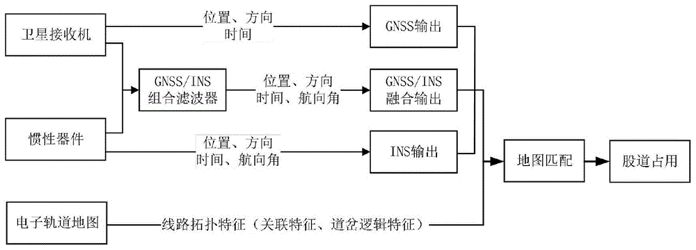
图1为本发明实施例所述的列车定位股道判别原理框图。FIG. 1 is a block diagram of the principle of discriminating a train positioning track according to an embodiment of the present invention.
图2为本发明实施例所述的列车定位股道判别方法流程图。FIG. 2 is a flowchart of a method for discriminating a train positioning track according to an embodiment of the present invention.
图3为本发明实施例所述的轨道线路拓扑关系示意图。FIG. 3 is a schematic diagram of a topological relationship of a track line according to an embodiment of the present invention.
图4为本发明实施例所述的对应图3中顺向通过道岔区域时,经过的轨道片段示意图。FIG. 4 is a schematic diagram of a track segment passing through the turnout area in the forward direction corresponding to FIG. 3 according to an embodiment of the present invention.
图5为本发明实施例所述的对应图3中对向通过道岔区域时,经过的轨道片段示意图。FIG. 5 is a schematic diagram of a track segment passing through when passing through the switch area in opposite directions in FIG. 3 according to an embodiment of the present invention.
具体实施方式Detailed ways
下面通过参考附图描述的实施方式是示例性的,仅用于解释本发明,而不能解释为对本发明的限制。The embodiments described below with reference to the accompanying drawings are exemplary and are only used to explain the present invention, but not to be construed as a limitation of the present invention.
本技术领域技术人员可以理解,除非特意声明,这里使用的单数形式“一”、“一个”、“所述”和“该”也可包括复数形式。应该进一步理解的是,本发明的说明书中使用的措辞“包括”是指存在所述特征、整数、步骤、操作、元件和/或模块,但是并不排除存在或添加一个或多个其他特征、整数、步骤、操作、元件、模块和/或它们的组。It will be understood by those skilled in the art that the singular forms "a", "an", "the" and "the" as used herein can include the plural forms as well, unless expressly stated otherwise. It should be further understood that the word "comprising" used in the description of the present invention refers to the presence of stated features, integers, steps, operations, elements and/or modules, but does not exclude the presence or addition of one or more other features, Integers, steps, operations, elements, modules and/or groups thereof.
本技术领域技术人员可以理解,除非另外定义,这里使用的所有术语(包括技术术语和科学术语)具有与本发明所属领域中的普通技术人员的一般理解相同的意义。还应该理解的是,诸如通用字典中定义的那些术语应该被理解为具有与现有技术的上下文中的意义一致的意义,并且除非像这里一样定义,不会用理想化或过于正式的含义来解释。It will be understood by those skilled in the art that, unless otherwise defined, all terms (including technical and scientific terms) used herein have the same meaning as commonly understood by one of ordinary skill in the art to which this invention belongs. It should also be understood that terms such as those defined in general dictionaries should be understood to have meanings consistent with their meanings in the context of the prior art and, unless defined as herein, are not to be taken in an idealized or overly formal sense. explain.
为便于对本发明实施例的理解,下面将结合附图以具体实施例为例做进一步的解释说明,且实施例并不构成对本发明实施例的限定。In order to facilitate the understanding of the embodiments of the present invention, the following will take specific embodiments as examples for further explanation and description in conjunction with the accompanying drawings, and the embodiments do not constitute limitations to the embodiments of the present invention.
本领域普通技术人员应当理解的是,附图只是一个实施例的示意图,附图中的部件或装置并不一定是实施本发明所必须的。It should be understood by those of ordinary skill in the art that the accompanying drawings are only schematic diagrams of one embodiment, and the components or devices in the accompanying drawings are not necessarily necessary for implementing the present invention.
实施例Example
本发明实施例提供一种在无轨旁设备情景下,利用车载的定位接收机、惯性器件以及地图数据库等多种传感器实现列车自主定位并作股道占用判别的方法。包括如下步骤:Embodiments of the present invention provide a method for autonomously locating a train and judging track occupancy by using a vehicle-mounted positioning receiver, an inertial device, a map database, and other sensors in a scenario without trackside equipment. It includes the following steps:
S1:提取定位信息,对卫星接收机与惯性导航系统解算得到的位置、航向角速度、方向等进行提取融合,得到位置、航向角、方向、时间等定位信息。S1: Extract positioning information, extract and fuse the position, heading angular velocity, direction, etc. calculated by the satellite receiver and the inertial navigation system to obtain positioning information such as position, heading angle, direction, and time.
在本发明实施例中,这里方向指的是列车的上下行方向,其决定了列车在经过道岔时为顺向或对向方向;航向角指的是以天向为轴,列车左右偏转的角度,也称偏航角。In the embodiment of the present invention, the direction here refers to the up and down direction of the train, which determines whether the train is in the forward or opposite direction when it passes the switch; the heading angle refers to the angle of the left and right deflection of the train with the sky direction as the axis , also known as the yaw angle.
如图1中所示,分别对卫星接收机和惯性导航系统的输出进行信息提取、分析与融合处理,采用卡尔曼滤波算法实现GNSS/INS组合定位算法,可输出信息融合前后的定位结果,包括位置(X、Y、Z)、时间(t)、方向(d)、航向角θ),其中GNSS、INS以及GNSS/INS融合的输出信息分别表示为:As shown in Figure 1, the output of the satellite receiver and the inertial navigation system are respectively subjected to information extraction, analysis and fusion processing, and the Kalman filter algorithm is used to realize the GNSS/INS combined positioning algorithm, and the positioning results before and after information fusion can be output, including Position (X, Y, Z), time (t), direction (d), heading angle θ), where the output information of GNSS, INS and GNSS/INS fusion is expressed as:
GNSS:(XGNSS,YGNSS,ZGNSS,tGNSS,dGNSS)、GNSS: (X GNSS ,Y GNSS ,Z GNSS ,t GNSS ,d GNSS ),
INS:(XINS,YINS,ZINS,tINS,dINS,θINS)、INS: (X INS , Y INS , Z INS , t INS , d INS , θ INS ),
GNSS/INS:(XGNSS/INS,YGNSS/INS,ZGNSS/INS,tGNSS/INS,dGNSS/INS,θGNSS/INS)。GNSS/INS: (X GNSS/INS , Y GNSS/INS , Z GNSS/INS , t GNSS/INS , d GNSS/INS , θ GNSS/INS ).
S2:进行电子轨道地图格式定义。提取线路拓扑特征,对道岔的逻辑特征以及线路的关联特征进行抽象表示。S2: Define the format of the electronic track map. Extract the line topology features, and abstractly represent the logical features of the switch and the associated features of the line.
由于地形等复杂因素,因此在对铁路线路进行线路拓扑特征提取时首先需要进行片段分割。依据线路的偏转角度大小,对轨道进行片段分割。Due to complex factors such as terrain, segment segmentation is required first when extracting topological features of railway lines. Segment the track according to the deflection angle of the line.
完成片段分割后,将所有轨道片段归纳为两类,无岔区段片段以及道岔区段片段。After segment segmentation is completed, all track segments are classified into two categories, non-switch segment segments and switch segment segments.
无岔区段拓扑特征主要指的是关联特征,即片段的前后连接关系。如图3中示意的轨道片段之间的线路拓扑关系,不妨设列车对向经过道岔区域,即图3中从右至左方向,t时刻列车股道占用结果为TPi+2,由关联特征,与TPi+2关联的轨道片段为TPi+1,TPi+3,同时列车运行方向确定(从右至左),那么t+1时刻列车股道占用结果只可能为TPi+2或TPi+1。Topological features of unforked segments mainly refer to association features, that is, the connection relationship between segments. For the line topology relationship between track segments shown in Figure 3, it may be assumed that the trains pass through the switch area in opposite directions, that is, from right to left in Figure 3, the result of the train track occupation at time t is TPi+2. The track segments associated with TPi+2 are TPi+1, TPi+3, and the train running direction is determined (from right to left), then the result of the train track occupation at time t+1 is only TPi+2 or
道岔区段与无岔区段不同,其拓扑特征指的是逻辑特征和关联特征。图4、图5分别为对应图3中顺向、对向通过道岔区域时经过的轨道片段示意图,顺向经过道岔区域时由于道岔分支,直向或侧向通过道岔产生了不同的占用轨道片段序列集;对向通过道岔区域时,无论直向或侧向通过道岔,占用轨道片段序列集均唯一。这里将顺向或对向通过道岔区域时产生占用片段序列集是否唯一这一特征总结为道岔的逻辑特征。The switch section is different from the non-switch section, and its topological features refer to logical features and associated features. Figures 4 and 5 are schematic diagrams of the track segments passing through the turnout area corresponding to the forward and opposite directions in Figure 3, respectively. When passing the turnout area in the forward direction, different occupied track segments are generated due to the branching of the turnout and the vertical or lateral passage of the turnout. Sequence set; when passing through the turnout area in opposite directions, the sequence set of the occupied track segment is unique regardless of whether it passes through the turnout vertically or laterally. Here, the feature of whether the occupied segment sequence set is unique when passing the turnout area in the forward or opposite direction is summarized as the logical feature of the turnout.
在对线路的关联特征以及道岔的逻辑特征进行抽象表示后,合理定义电子轨道地图格式以使电子轨道地图包含线路拓扑特征,如表1所示,电子轨道地图的相关定义,描述了电子轨道地图中每一轨道片段的结构。After abstracting the associated features of the line and the logical features of the switch, the electronic track map format is reasonably defined so that the electronic track map contains the line topology features. As shown in Table 1, the relevant definitions of the electronic track map describe the electronic track map. The structure of each track segment in .
表1Table 1

S3:进行平行股道占用判别,利用线路关联特征及先验信息构建时空约束关系,建立相应概率模型,应用多假设-检验方法,对列车自主定位结果进行地图匹配,准确判别列车当前占用股道。S3: Perform parallel track occupancy discrimination, use line correlation features and prior information to construct spatiotemporal constraints, establish a corresponding probability model, and apply multiple hypothesis-testing methods to map the results of autonomous train positioning to accurately determine the track currently occupied by the train. .
列车运行在平行股道时,平行股道情景下无道岔,应用基于距离方向与线路拓扑关系的地图匹配算法进行地图匹配,确定平行股道情景下股道占用情况。When the train runs on the parallel track, there is no turnout in the parallel track scenario. The map matching algorithm based on the distance direction and the line topology is used to perform map matching to determine the track occupancy in the parallel track scenario.
首先由当前定位点坐标PGNSS/INS(XGNSS/INS|t,YGNSS/INS|t,ZGNSS/INS|t)确定占用股道假设集Ht,利用垂直投影法计算定位点至各假设占用股道的点线距离dpoint2piece(i);First, determine the occupied track hypothesis set H t from the coordinates of the current positioning point P GNSS/INS (X GNSS/INS|t , Y GNSS/INS|t , Z GNSS/INS|t ), and use the vertical projection method to calculate the positioning point to each Assume that the point-line distance d point2piece(i) occupies the track;
连接当前定位点PGNSS/INS(XGNSS/INS|t,YGNSS/INS|t,ZGNSS/INS|t)与前一时刻定位点PGNSS/INS(XGNSS/INS|t-1,YGNSS/INS|t-1,ZGNSS/INS|t-1),计算连线与正北方向夹角θpoint、候选股道与正北方向夹角θpiece之差,Δθ=|θpoint-θpiece|Connect the current fix point P GNSS/INS (X GNSS/INS|t , Y GNSS/INS|t , Z GNSS/INS|t ) with the previous time fix point P GNSS/INS (X GNSS/INS|t-1 , Y GNSS/INS|t-1 , Z GNSS/INS|t-1 ), calculate the difference between the angle θ point between the connection line and the true north direction, and the angle θ piece between the candidate track and the true north direction, Δθ=|θ point -θ piece |
利用dpoint2piece(i)与Δθ=|θpoint-θpiece|构建概率模型(即判别模型,该模型为现有技术中通用的最优估计算法,在此不再赘述),计算匹配至各候选股道的概率Ppoint2piece(i),由匹配概率得到初步匹配结果,
对初步匹配结果对应假设进行检验,为非道岔区段;The corresponding hypothesis of the preliminary matching result is tested, and it is a non-turnout section;
由电子轨道地图,提取上一时刻地图匹配结果Match(t-1)对应的拓扑关系,进一步检验初步匹配结果,得到最终股道占用结果Match(t)。From the electronic track map, the topological relationship corresponding to the map matching result Match(t-1) at the previous moment is extracted, and the preliminary matching result is further checked to obtain the final track occupation result Match(t).
S4:进行岔区股道占用判别,利用道岔逻辑特征及列车运行航向角信息构建时空及方向约束关系,建立相应概率模型,应用多假设-检验方法,对列车岔区定位结果进行地图匹配,准确判别列车当前占用道岔股道。S4: Determine the occupancy of the track in the turnout area, use the logic feature of the turnout and the information of the heading angle of the train to construct the space-time and direction constraint relationship, establish the corresponding probability model, and apply the multi-hypothesis-testing method to map the location results of the train turnout area. It is judged that the train currently occupies the turnout track.
与进行平行股道占用判别相同,提取距离、方向信息并建立对应概率模型,得到初步匹配结果
对初步匹配结果对应假设进行检验,为道岔区段;Test the corresponding hypothesis of the preliminary matching result, which is the turnout section;
判断列车运行方向与道岔的相对方向,以单开道岔为例:To judge the running direction of the train and the relative direction of the turnout, take a single turnout as an example:
列车顺向通过道岔时,依据计算处理得到的航向角速度Vyaw(t)信息判断运动方向,即正向经过道岔或侧向经过道岔;When the train passes the turnout in the forward direction, the movement direction is judged according to the information of the heading angular velocity V yaw (t) obtained by the calculation process, that is, the train passes the turnout in the forward direction or the turnout in the lateral direction;
列车对向通过道岔时,进行下一步,依据线路关联关系对初步匹配结果进行检验。When the train passes the turnout in the opposite direction, proceed to the next step, and check the preliminary matching results according to the line relationship.
由电子轨道地图,提取上一时刻地图匹配结果Match(t-1)对应的拓扑关系,依据线路关联关系对初步匹配结果进行检验,得到最终股道占用结果Match(t)。From the electronic track map, the topological relationship corresponding to the map matching result Match(t-1) at the previous moment is extracted, and the preliminary matching results are checked according to the line association relationship, and the final track occupation result Match(t) is obtained.
以上所述,仅为本发明较佳的具体实施方式,但本发明的保护范围并不局限于此,任何熟悉本技术领域的技术人员在本发明揭露的技术范围内,可轻易想到的变化或替换,都应涵盖在本发明的保护范围之内。因此,本发明的保护范围应该以权利要求的保护范围为准。The above description is only a preferred embodiment of the present invention, but the protection scope of the present invention is not limited to this. Substitutions should be covered within the protection scope of the present invention. Therefore, the protection scope of the present invention should be subject to the protection scope of the claims.
Claims (3)


Priority Applications (1)
| Application Number | Priority Date | Filing Date | Title |
|---|---|---|---|
| CN202110089291.6A CN112722013B (en) | 2021-01-22 | 2021-01-22 | Train positioning track distinguishing method |
Applications Claiming Priority (1)
| Application Number | Priority Date | Filing Date | Title |
|---|---|---|---|
| CN202110089291.6A CN112722013B (en) | 2021-01-22 | 2021-01-22 | Train positioning track distinguishing method |
Publications (2)
| Publication Number | Publication Date |
|---|---|
| CN112722013A CN112722013A (en) | 2021-04-30 |
| CN112722013B true CN112722013B (en) | 2022-03-25 |
Family
ID=75593797
Family Applications (1)
| Application Number | Title | Priority Date | Filing Date |
|---|---|---|---|
| CN202110089291.6A Active CN112722013B (en) | 2021-01-22 | 2021-01-22 | Train positioning track distinguishing method |
Country Status (1)
| Country | Link |
|---|---|
| CN (1) | CN112722013B (en) |
Families Citing this family (7)
| Publication number | Priority date | Publication date | Assignee | Title |
|---|---|---|---|---|
| CN113815683A (en) * | 2021-08-25 | 2021-12-21 | 通号城市轨道交通技术有限公司 | Train positioning method and device, electronic equipment and storage medium |
| CN113706617B (en) * | 2021-08-30 | 2024-08-02 | 卡斯柯信号有限公司 | Multi-track train positioning method, system, background server and readable storage medium |
| CN113928381B (en) * | 2021-11-15 | 2024-10-11 | 交控科技股份有限公司 | Train departure method and device |
| CN114044027B (en) * | 2021-12-24 | 2024-03-26 | 卡斯柯信号有限公司 | Method for realizing train positioning on two-dimensional electronic map |
| CN114954580B (en) * | 2022-05-17 | 2024-04-26 | 交控科技股份有限公司 | Mobile occlusion column control method, device, equipment and medium based on Beidou positioning |
| CN115906572B (en) * | 2022-11-29 | 2025-12-12 | 中铁第四勘察设计院集团有限公司 | A Topology Optimization Design Method for Concrete-Concrete Composite Steel Tube Railway Sleeper Based on APDL |
| CN119618238A (en) * | 2024-09-04 | 2025-03-14 | 武汉钢铁有限公司 | A fusion positioning method and related equipment for a molten iron tank car |
Citations (9)
| Publication number | Priority date | Publication date | Assignee | Title |
|---|---|---|---|---|
| ES2297653T3 (en) * | 2005-03-21 | 2008-05-01 | Sener, Ingenieria Y Sistemas, S.A. | SYSTEM AND METHOD OF LOCKING WITH INTRINSECA SECURITY, FOR RAILWAY LINES OF LOW TRAFFIC DENSITY. |
| CN103770808A (en) * | 2014-01-26 | 2014-05-07 | 北京交通大学 | Auxiliary train protection system and method based on Beidou navigation |
| CN107402006A (en) * | 2017-07-24 | 2017-11-28 | 武汉大学 | Train precision positioning method and system based on the matching of track geometry characteristic information |
| CN107976697A (en) * | 2017-11-30 | 2018-05-01 | 中国铁路总公司 | Train safe positioning method and system of the one kind based on the Big Dipper/GPS combinations |
| CN109085631A (en) * | 2018-08-01 | 2018-12-25 | 北京交通大学 | Trouble area train track based on satellite positioning weights recognition methods |
| CN109471143A (en) * | 2018-12-11 | 2019-03-15 | 北京交通大学 | Adaptive Fault Tolerant Train Combination Localization Method |
| CN109471144A (en) * | 2018-12-13 | 2019-03-15 | 北京交通大学 | Combined localization method of multi-sensor compact train based on pseudorange/pseudorange rate |
| CN109484435A (en) * | 2018-11-28 | 2019-03-19 | 交控科技股份有限公司 | A kind of train locating method and device suitable for intelligent track-traffic detection system |
| CN110567456A (en) * | 2019-09-03 | 2019-12-13 | 兰州交通大学 | BDS/INS Combined Train Location Method Based on Robust Kalman Filter |
Family Cites Families (1)
| Publication number | Priority date | Publication date | Assignee | Title |
|---|---|---|---|---|
| CN108196289B (en) * | 2017-12-25 | 2019-11-26 | 北京交通大学 | A kind of train combined positioning method under satellite-signal confined condition |
-
2021
- 2021-01-22 CN CN202110089291.6A patent/CN112722013B/en active Active
Patent Citations (9)
| Publication number | Priority date | Publication date | Assignee | Title |
|---|---|---|---|---|
| ES2297653T3 (en) * | 2005-03-21 | 2008-05-01 | Sener, Ingenieria Y Sistemas, S.A. | SYSTEM AND METHOD OF LOCKING WITH INTRINSECA SECURITY, FOR RAILWAY LINES OF LOW TRAFFIC DENSITY. |
| CN103770808A (en) * | 2014-01-26 | 2014-05-07 | 北京交通大学 | Auxiliary train protection system and method based on Beidou navigation |
| CN107402006A (en) * | 2017-07-24 | 2017-11-28 | 武汉大学 | Train precision positioning method and system based on the matching of track geometry characteristic information |
| CN107976697A (en) * | 2017-11-30 | 2018-05-01 | 中国铁路总公司 | Train safe positioning method and system of the one kind based on the Big Dipper/GPS combinations |
| CN109085631A (en) * | 2018-08-01 | 2018-12-25 | 北京交通大学 | Trouble area train track based on satellite positioning weights recognition methods |
| CN109484435A (en) * | 2018-11-28 | 2019-03-19 | 交控科技股份有限公司 | A kind of train locating method and device suitable for intelligent track-traffic detection system |
| CN109471143A (en) * | 2018-12-11 | 2019-03-15 | 北京交通大学 | Adaptive Fault Tolerant Train Combination Localization Method |
| CN109471144A (en) * | 2018-12-13 | 2019-03-15 | 北京交通大学 | Combined localization method of multi-sensor compact train based on pseudorange/pseudorange rate |
| CN110567456A (en) * | 2019-09-03 | 2019-12-13 | 兰州交通大学 | BDS/INS Combined Train Location Method Based on Robust Kalman Filter |
Non-Patent Citations (3)
| Title |
|---|
| 基于GNSS/INS的列车定位风险评估方法;吴波前等;《西南交通大学学报》;20201231;第55卷(第6期);引言,第1章,第2章 * |
| 基于GNSS的股道占用识别方法研究;徐佳佳;《中国优秀博硕士学位论文全文数据库(硕士)工程科技Ⅱ辑》;20160616(第7期);第2章,第3章 * |
| 基于贝叶斯估计的轨道占用识别方法;胡永兴等;《铁道通信信号》;20160630;第52卷(第6期);全文 * |
Also Published As
| Publication number | Publication date |
|---|---|
| CN112722013A (en) | 2021-04-30 |
Similar Documents
| Publication | Publication Date | Title |
|---|---|---|
| CN112722013B (en) | Train positioning track distinguishing method | |
| CN108725520B (en) | Train operation control system suitable for low-density railway | |
| CN109774748B (en) | Train overspeed protection method, on-board controller and train based on train-to-train communication | |
| EP3473522B1 (en) | Vehicle on-board controller centered train operation control system | |
| CN107533630A (en) | For the real time machine vision of remote sense and wagon control and put cloud analysis | |
| CN107976697A (en) | Train safe positioning method and system of the one kind based on the Big Dipper/GPS combinations | |
| CN102923167A (en) | Train tracking and approaching pre-warning system | |
| CN107323484A (en) | Train control system based on Big Dipper short message and truck traffic | |
| CN104269048A (en) | Dynamic Scheduling And Time Control For Intelligent Bus System | |
| US20200189633A1 (en) | Rail vehicle obstacle avoidance and vehicle localization | |
| CN106991725A (en) | Region freeway net vehicle running path analytical equipment and analysis method | |
| CN105857349A (en) | Precise train positioning system based on comprehensive positioning | |
| CN108773393B (en) | BTM for storing messages | |
| CN107861142A (en) | A kind of positioning combined based on the Big Dipper and multi information and air navigation aid | |
| CN107336723A (en) | Train integrity monitoring system based on radio communication, satellite navigation and inertial navigation | |
| CN109147323A (en) | A kind of vehicle GPS data processing method for highway passenger and freight transportation indicator-specific statistics | |
| CN112406965B (en) | Method and system for improving train positioning safety | |
| CN118298626A (en) | Auxiliary positioning method for tunnel vehicles based on roadside video stream trajectory tracking | |
| CN111776021A (en) | Method and system for realizing positioning verification of rail vehicle | |
| CN207015356U (en) | Train control system based on Big Dipper short message and truck traffic | |
| CN105667543A (en) | Method for discriminating presence of railway vehicle on block, method for calculating safety interval and associated device | |
| Su et al. | Enhanced Safety Messages (ESM): A Practical Alternative to V2X Basic Safety Messages | |
| CN100362363C (en) | Method for reliably determining the position of an object, especially a vehicle moving along a known route | |
| CN120422905A (en) | Train traveling track autonomous verification system based on space-time feature fusion | |
| CN112622987A (en) | Train autonomous positioning speed measurement and integrity check system and method |
Legal Events
| Date | Code | Title | Description |
|---|---|---|---|
| PB01 | Publication | ||
| PB01 | Publication | ||
| SE01 | Entry into force of request for substantive examination | ||
| SE01 | Entry into force of request for substantive examination | ||
| GR01 | Patent grant | ||
| GR01 | Patent grant | ||
| TR01 | Transfer of patent right | ||
| TR01 | Transfer of patent right |
Effective date of registration: 20240206 Address after: 13B-128, 13th Floor, Building 89, Zone 1, No. 44 Gaoliangqiao Xiejie Street, Haidian District, Beijing, 100044 Patentee after: Jiaotong University Zhiyuan (Beijing) Technology Co.,Ltd. Country or region after: China Address before: 100044 Beijing city Haidian District Xizhimen Shangyuan Village No. 3 Patentee before: Beijing Jiaotong University Country or region before: China |