CN112896231B - Railway track sand burying degree monitoring device and method - Google Patents
Railway track sand burying degree monitoring device and method Download PDFInfo
- Publication number
- CN112896231B CN112896231B CN202110226072.8A CN202110226072A CN112896231B CN 112896231 B CN112896231 B CN 112896231B CN 202110226072 A CN202110226072 A CN 202110226072A CN 112896231 B CN112896231 B CN 112896231B
- Authority
- CN
- China
- Prior art keywords
- image
- sand
- train
- rail
- delta
- Prior art date
- Legal status (The legal status is an assumption and is not a legal conclusion. Google has not performed a legal analysis and makes no representation as to the accuracy of the status listed.)
- Active
Links
Images



Classifications
-
- B—PERFORMING OPERATIONS; TRANSPORTING
- B61—RAILWAYS
- B61K—AUXILIARY EQUIPMENT SPECIALLY ADAPTED FOR RAILWAYS, NOT OTHERWISE PROVIDED FOR
- B61K9/00—Railway vehicle profile gauges; Detecting or indicating overheating of components; Apparatus on locomotives or cars to indicate bad track sections; General design of track recording vehicles
- B61K9/08—Measuring installations for surveying permanent way
-
- H—ELECTRICITY
- H04—ELECTRIC COMMUNICATION TECHNIQUE
- H04N—PICTORIAL COMMUNICATION, e.g. TELEVISION
- H04N23/00—Cameras or camera modules comprising electronic image sensors; Control thereof
- H04N23/56—Cameras or camera modules comprising electronic image sensors; Control thereof provided with illuminating means
-
- H—ELECTRICITY
- H04—ELECTRIC COMMUNICATION TECHNIQUE
- H04N—PICTORIAL COMMUNICATION, e.g. TELEVISION
- H04N23/00—Cameras or camera modules comprising electronic image sensors; Control thereof
- H04N23/57—Mechanical or electrical details of cameras or camera modules specially adapted for being embedded in other devices
-
- H—ELECTRICITY
- H04—ELECTRIC COMMUNICATION TECHNIQUE
- H04N—PICTORIAL COMMUNICATION, e.g. TELEVISION
- H04N23/00—Cameras or camera modules comprising electronic image sensors; Control thereof
- H04N23/80—Camera processing pipelines; Components thereof
-
- H—ELECTRICITY
- H04—ELECTRIC COMMUNICATION TECHNIQUE
- H04N—PICTORIAL COMMUNICATION, e.g. TELEVISION
- H04N23/00—Cameras or camera modules comprising electronic image sensors; Control thereof
- H04N23/90—Arrangement of cameras or camera modules, e.g. multiple cameras in TV studios or sports stadiums
Landscapes
- Engineering & Computer Science (AREA)
- Multimedia (AREA)
- Signal Processing (AREA)
- Mechanical Engineering (AREA)
- Train Traffic Observation, Control, And Security (AREA)
Abstract
Description
技术领域technical field
本发明涉及到一种铁路维护技术,特别涉及一种铁路轨道埋沙程度监测装置及方法。The invention relates to a railway maintenance technology, in particular to a device and method for monitoring the sand burial degree of a railway track.
背景技术Background technique
随着西北地区轨道交通网络的完善,途经荒漠化地区的铁路应对黄沙侵袭的措施的研发就显得尤其必要。目前主要是在风沙危害严重的地区建设防护林或固沙带,其成本极为昂贵,难以实现对全线路的保护。也有部分线路在沙埋危害严重的路段利用图像监控系统进行监测,并将视频或图像信息传回控制中心进行处理后进行道路的人工维护决策。由于建造成本过高,很多路段没有监控设备,无法及时获取沙埋状况的信息,给车辆运行带来一定风险。另外,对于一些新的活化沙源地导致的铁轨掩埋问题如何及时识别,并及时进行预警和处理,目前暂缺乏相应的技术手段。。With the improvement of the rail transit network in the northwest region, the research and development of measures for the railways passing through desertified areas to deal with the invasion of yellow sand is particularly necessary. At present, shelter forests or sand-fixing belts are mainly built in areas with severe sand damage, which are extremely expensive and difficult to protect the entire line. There are also some lines that use image monitoring systems to monitor the road sections with serious sand burial hazards, and send video or image information back to the control center for processing to make manual maintenance decisions. Due to the high construction cost, many road sections do not have monitoring equipment, and it is impossible to obtain information on the sand burial condition in time, which brings certain risks to vehicle operation. In addition, there is currently a lack of corresponding technical means for how to identify the railway track burial problems caused by some new activated sand sources, and to carry out early warning and treatment in a timely manner. .
现有铁路沙埋危害的防护主要是在相关路段建设防护林,或设置高立式沙障、土工网格、挖截沙沟、筑挡沙墙、栽种树枝沙障、铺设砂夹石等等固沙技术进行防护。不过,由于沙漠中风沙大、日照强,防沙网格经常被风撕裂,必须定期进行修理和维护,导致的经济损失非常严重。同时铁路线过长,全部建造防护带经济成本过高,不具实施性。另外也有学者尝试采用化学材料喷涂方式固沙,但因为材料耐用用、环境健康性等问题而被放弃大范围应用。对于沙埋的监测,铁路部门尝试在一些沙埋危害严重区域安装图像监控系统,通过采集图像-图像处理-人工判断-人工决策的方式来实施铁路沙埋危害的监测。由于是定点监测,监测点很有限,监控范围越大建造成本越高,因此并未大范围采纳。另外,对新的沙源活化路段无法给出必要信息,从而无法根本上保障车辆运行安全。目前这方面主要靠人工巡检发现。所以需要一种能采集铁轨的图像同时附带地理信息,同时图像采集效果好的监测装置。The protection of existing railway sand burial hazards is mainly to build shelter forests on relevant road sections, or set up high vertical sand barriers, geogrids, dig and intercept sand trenches, build sand retaining walls, plant tree branches sand barriers, lay sand and stones, etc. to fix sand. technology for protection. However, due to the strong sandstorm and strong sunshine in the desert, the sand control grid is often torn by the wind and must be repaired and maintained regularly, resulting in very serious economic losses. At the same time, the railway line is too long, and the economic cost of building all the protective belts is too high, which is not practical. In addition, some scholars have tried to use chemical material spraying to fix sand, but they have been abandoned for large-scale applications due to problems such as material durability and environmental health. For the monitoring of sand burial, the railway department tries to install image monitoring systems in some areas with serious sand burial hazards, and implements the monitoring of railway sand burial hazards by collecting images - image processing - manual judgment - manual decision-making. Because it is fixed-point monitoring, the monitoring points are very limited, and the larger the monitoring scope, the higher the construction cost, so it is not widely adopted. In addition, necessary information cannot be given to the new sand source activation road section, so that the safety of vehicle operation cannot be fundamentally guaranteed. At present, this aspect is mainly detected by manual inspection. Therefore, there is a need for a monitoring device that can collect images of railroad tracks with geographic information and has a good image collection effect.
发明内容SUMMARY OF THE INVENTION
发明的目的在于提供一种铁路轨道埋沙程度监测装置及方法,该发明具有能实时采集铁轨的图像同时附带地理信息,图像采集效果好,能大大减少铁轨的维护成本的优点,以解决上述背景技术中提出的问题。The purpose of the invention is to provide a monitoring device and method for the degree of sand burial of a railway track. The invention has the advantages of being able to collect the image of the railway track in real time and accompanied by geographic information, the image collection effect is good, and the maintenance cost of the railway track can be greatly reduced, so as to solve the above-mentioned background. Issues raised in technology.
为实现上述目的,本发明提供如下技术方案:To achieve the above object, the present invention provides the following technical solutions:
一种铁路轨道埋沙程度监测装置,包括安装架和图像采集设备,所述安装架通过螺栓固定在火车上,所述图像采集设备安装在安装架的侧壁上,安装架包括第一横板、第二横板、竖板、挡板和盖板,盖板的底端通过合页与第二横板活动连接,盖板的顶端与第一横板边缘接触,第一横板和第二横板均固定在竖板的侧壁上,竖板和第一横板均通过螺栓固定连接火车,第二横板上安装图像采集设备,图像采集设备包括采集摄像头、补光灯和GPS定位器,GPS定位器安装在第二横板的上方,第二横板的下表面安装有采集摄像头和补光灯,GPS定位器通过导线连接采集摄像头,补光灯位于采集摄像头的一侧,竖板的底端安装有挡板。A device for monitoring the sand burial degree of railway tracks, comprising an installation frame and an image acquisition device, the installation frame is fixed on a train by bolts, the image capture device is installed on the side wall of the installation frame, and the installation frame includes a first horizontal plate , the second horizontal plate, the vertical plate, the baffle plate and the cover plate, the bottom end of the cover plate is movably connected with the second horizontal plate through hinges, the top of the cover plate is in contact with the edge of the first horizontal plate, the first horizontal plate and the second horizontal plate are in contact with each other. The horizontal plates are fixed on the side walls of the vertical plates, the vertical plates and the first horizontal plate are connected to the train by bolts, and the image acquisition equipment is installed on the second horizontal plate. The image acquisition equipment includes acquisition cameras, fill lights and GPS locators , the GPS locator is installed above the second horizontal plate, the lower surface of the second horizontal plate is equipped with a collection camera and a fill light, the GPS locator is connected to the collection camera through a wire, the fill light is located on one side of the collection camera, and the vertical plate A baffle is installed at the bottom of the .
优选的,所述采集摄像头共设有四个,四个采集摄像头分为两对,两对采集摄像头分别布置在铁轨的两侧斜上方。Preferably, there are four acquisition cameras in total, the four acquisition cameras are divided into two pairs, and the two pairs of acquisition cameras are respectively arranged obliquely above both sides of the rail.
优选的,所述补光灯和采集摄像头的镜头均朝向铁轨内外壁。Preferably, both the fill light and the lens of the capturing camera face toward the inner and outer walls of the rail.
优选的,所述挡板为一种透明亚克力板。Preferably, the baffle is a transparent acrylic plate.
优选的,所述盖板的顶端安装有卡扣和把手,盖板通过卡扣连接第一横板。Preferably, a buckle and a handle are installed on the top of the cover plate, and the cover plate is connected to the first horizontal plate through the buckle.
本发明要解决的另一技术问题是提供一种铁路轨道埋沙程度监测装置的实施方法,包括如下步骤:Another technical problem to be solved by the present invention is to provide an implementation method of a railway track sand burial degree monitoring device, comprising the following steps:
S1:设备安装,先将图像采集设备安装在安装架上,其中GPS定位器安装后需要封上盖板,图像采集设备中的采集摄像头和补光灯安装在挡板的后侧,避免其直接迎风,同时采集摄像头的镜头朝向铁轨内外侧;S1: Equipment installation, first install the image acquisition equipment on the mounting frame, and the cover plate needs to be closed after the GPS locator is installed. The acquisition camera and fill light in the image acquisition equipment are installed on the back side of the baffle to avoid direct Facing the wind, at the same time, the lens of the acquisition camera faces the inside and outside of the rail;
S2:运行取相,在火车的带动下,图像采集设备2对铁轨及枕木进行连续拍照取相,同时在GPS定位器23的配合下,可以获得带有经纬度信息的图像,具体的来说,在火车行驶速度为v时,调整图像采集系统帧率,设置帧率为
S3:图像处理,图像处理是为了检测铁轨和枕木,在进行图像处理时,需要计算铁轨和枕木二者在单幅图像中像素数目为x1,y1,假定在铁轨间无沙时获取图像中铁轨所占像素数目x0,枕木所占像素数目y0,且

S4:重点区域后续处理,在重点区域后ti时刻采集的图像经数字图像处理,计算铁轨和枕木所占有的像素元分别记为xi,yi(i≥2),计算

S5:人员检查,当系统检测到可能出现沙尘已与铁轨高度持平的情况时,应及时派工作人员到重点区域对铁轨进行实地巡查,并清除沙尘。S5: Personnel inspection. When the system detects that the sand and dust may be equal to the height of the rails, staff should be dispatched to key areas to conduct on-site inspections of the rails and remove sand and dust.
优选的,所述S3中,图像处理数据处理后出现图像识别发现多个枕木存在不连续现象,或δ1与δ2不满足上述条件,说明该位置处已有沙尘累计,保存对应的图像和GPS信息,将其存储于指定文件中,并指令传感器在后续到达该位置处时均加密拍照,并将此处检测确定的重点监测位置分别记为A(i),此处i只表示这样的位置存在多处。Preferably, in the step S3, after the image processing data is processed, it is found that there are discontinuities in a plurality of sleepers through image recognition, or δ 1 and δ 2 do not meet the above conditions, indicating that sand and dust has accumulated at the position, and the corresponding image is saved. and GPS information, store it in the specified file, and instruct the sensor to encrypt and take pictures when it arrives at the location subsequently, and record the key monitoring locations determined by the detection here as A(i), where i only means this There are multiple locations.
优选的,所述S4中,重点区域后续处理过程中可能出现δi快速激增的情况,即获得一定的关于ti,δi,βi数据后,可对δi,βi增加固定比率所需的时长Δ进行估算,假定根据已获得的历史数据,δi由40%增加至60%需要2天,那么在检测到δi接近设定阈值后就需及时安排相关人员去进行清理,以保障列车行驶安全。Preferably, in the step S4, a rapid surge of δ i may occur during the subsequent processing of key areas, that is, after obtaining certain data about t i , δ i , and β i , it is possible to increase δ i , β i by a fixed ratio It is assumed that according to the obtained historical data, it takes 2 days for δ i to increase from 40% to 60%. Then, after detecting that δ i is close to the set threshold, it is necessary to arrange relevant personnel to clean it up in time. Ensure the safety of trains.
优选的,所述S2中,运行取相结束后不仅可以通过无线数据网络将图像信息数据实时传输给远处的控制中心,还能将图像信息数据暂存在火车上待到终点站,或有稳定信号的数据中继站时发送至控制中心。Preferably, in the S2, after the operation phase acquisition is completed, not only can the image information data be transmitted to the remote control center in real time through the wireless data network, but also the image information data can be temporarily stored on the train until it reaches the terminal, or there is a stable The data relay station of the signal is sent to the control center.
与现有技术相比,本发明的有益效果是:本发明提出的本铁路轨道埋沙程度监测装置及方法,火车行驶的过程中,图像采集设备就能对轨道进行图像采集,并将采集的图像和地理位置信息发送至数据处理中心,借助计算机设备进行图像处理,从而获得图像采集地点铁轨的沙埋情况,补光灯的安装能在昏暗情况下进行补光,挡板在不影响光照的情况下挡住沙尘;其中获得带有经纬度信息的图像后,同时基于采集到的图像信息建立数据库,进行图像处理时,需要计算铁轨和枕木二者在单幅图像中像素数目为x1,y1,当没有沙埋情况发生时,可以每隔t天采集一次数据进行检测,当出现有沙尘累计,应每次到达该位置处时均拍照1次,并将此处检测确定的重点区域,并对重点区域采集的图像再次处理,若经当δ≥60%时,可能出现沙尘已与铁轨高度持平的情况,应及时派工作人员到重点区域对铁轨进行实地巡查,并清除沙尘;在重点区域后续处理过程中可能出现δi快速激增的情况,也应进行清理,以保障列车行驶安全,通过图像采集设备和对图像的后续处理,能大大减少铁轨的维护成本。Compared with the prior art, the beneficial effects of the present invention are: the device and method for monitoring the sand burial degree of the railway track proposed by the present invention, the image acquisition device can perform image acquisition on the track during the running of the train, and the collected data can be collected. The image and geographic location information are sent to the data processing center, and image processing is carried out with the help of computer equipment to obtain the sand burial of the rails at the image collection site. In the case of blocking sand and dust; in which, after obtaining the image with latitude and longitude information, a database is established based on the collected image information at the same time. When performing image processing, it is necessary to calculate the number of pixels in a single image for both the rail and the sleeper as x 1 , y 1. When there is no sand burial, data can be collected every t days for detection. When there is accumulation of sand and dust, a photo should be taken every time you arrive at the location, and the key areas determined by the detection will be taken here. , and reprocess the images collected in the key areas. If the δ ≥ 60%, the sand and dust may be equal to the height of the rails. Staff should be dispatched to the key areas to conduct on-site inspections of the rails and remove the sand and dust. ; In the follow-up process of key areas, there may be a rapid surge of δ i , which should also be cleaned up to ensure the safety of trains. Through the image acquisition equipment and the follow-up processing of the images, the maintenance cost of the rails can be greatly reduced.
附图说明Description of drawings
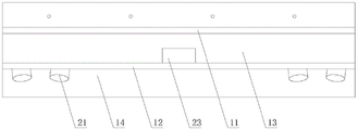
图1为本发明的整体结构侧视示意图;1 is a schematic side view of the overall structure of the present invention;
图2为本发明的整体结构正向示意图;Fig. 2 is the front schematic diagram of the overall structure of the present invention;
图3为本发明的安装架结构示意图;3 is a schematic diagram of the structure of the mounting frame of the present invention;
图4为本发明的盖板结构示意图。FIG. 4 is a schematic diagram of the structure of the cover plate of the present invention.
图中:1、安装架;11、第一横板;12、第二横板;13、竖板;14、挡板;15、盖板;151、卡扣;152、把手;2、图像采集设备;21、采集摄像头;22、补光灯;23、GPS定位器。In the figure: 1. Mounting frame; 11. The first horizontal plate; 12. The second horizontal plate; 13. Vertical plate; 14. The baffle plate; 15. The cover plate; Equipment; 21. Capture camera; 22. Fill light; 23. GPS locator.
具体实施方式Detailed ways
下面将结合本发明实施例中的附图,对本发明实施例中的技术方案进行清楚、完整地描述,显然,所描述的实施例仅仅是本发明一部分实施例,而不是全部的实施例。基于本发明中的实施例,本领域普通技术人员在没有做出创造性劳动前提下所获得的所有其他实施例,都属于本发明保护的范围。The technical solutions in the embodiments of the present invention will be clearly and completely described below with reference to the accompanying drawings in the embodiments of the present invention. Obviously, the described embodiments are only a part of the embodiments of the present invention, but not all of the embodiments. Based on the embodiments of the present invention, all other embodiments obtained by those of ordinary skill in the art without creative efforts shall fall within the protection scope of the present invention.
请参阅图1-4,一种铁路轨道埋沙程度监测装置,包括安装架1和图像采集设备2,安装架1通过螺栓固定在火车上,图像采集设备2安装在安装架1的侧壁上,即整个安装架1和图像采集设备2布置在火车头或车身或车尾,火车行驶的过程中,火车带动安装架1和图像采集设备2,图像采集设备2就能对轨道进行图像采集,并将采集的图像和地理位置信息发送至数据处理中心,借助计算机设备进行图像处理,从而获得图像采集地点铁轨的沙埋情况,安装架1包括第一横板11、第二横板12、竖板13、挡板14和盖板15,盖板15的底端通过合页与第二横板12活动连接,盖板15的顶端与第一横板11边缘接触,盖板15的顶端安装有卡扣151和把手152,盖板15通过卡扣151连接第一横板11,其中卡扣151用于盖板15与第一横板11的连接,把手152的安装便于操作盖板15,第一横板11和第二横板12均固定在竖板13的侧壁上,竖板13和第一横板11均通过螺栓固定连接火车,第二横板12上安装图像采集设备2,图像采集设备2包括采集摄像头21、补光灯22和GPS定位器23,GPS定位器23安装在第二横板12的上方,即GPS定位器23布置在第一横板11、第二横板12和盖板15构成的空腔中,盖板15的安装可避免沙尘侵入GPS定位器23,第二横板12的下表面安装有采集摄像头21和补光灯22,采集摄像头21对轨道进行图像采集,补光灯22的安装能在昏暗情况下进行补光,保证采集摄像头21能正常的进行图像采集,GPS定位器23通过导线连接采集摄像头21,这样采集摄像头21采集到的图像信息可以加入地理位置信息,补光灯22位于采集摄像头21的一侧,采集摄像头21共设有四个,四个采集摄像头21分为两对,两对采集摄像头21分别布置在铁轨的两侧斜上方,补光灯22和采集摄像头21的镜头均朝向铁轨内外壁,竖板13的底端安装有挡板14,挡板14为一种透明亚克力板,采用透明亚克力制成的挡板14不仅可以挡住沙尘,避免沙尘侵蚀采集摄像头21与补光灯22,同时透明的特性能保证光照,保证图像采集设备2能正常的进行图像采集,当然挡板14还可以采用高透光的钢化玻璃代替。Please refer to Figure 1-4, a railway track sand burial degree monitoring device, including a mounting
一种铁路轨道埋沙程度监测装置的实施方法,包括如下步骤:An implementation method of a railway track sand burial degree monitoring device, comprising the following steps:
第一步:设备安装,先将图像采集设备2安装在安装架1上,其中GPS定位器23安装后需要封上盖板15,图像采集设备2中的采集摄像头21和补光灯22安装在挡板14的后侧,避免其直接迎风,同时采集摄像头21的镜头朝向铁轨内外侧。The first step: equipment installation, first install the image capture device 2 on the mounting
第二步:运行取相,在火车的带动下,图像采集设备2对铁轨及枕木进行连续拍照取相,同时在GPS定位器23的配合下,可以获得带有经纬度信息的图像,具体的来说,在火车行驶速度为v时,调整图像采集系统帧率,设置帧率为
第三步:图像处理,图像处理是为了检测铁轨和枕木,在进行图像处理时,需要计算铁轨和枕木二者在单幅图像中像素数目为x1,y1,且

第四步:重点区域后续处理,在重点区域后ti时刻采集的图像经数字图像处理后,计算铁轨和枕木所占有的像素元分别记为xi,yi(i≥2),计算

第五步:人员检查,当系统检测到可能出现沙尘已与铁轨高度持平的情况时,应及时派工作人员到重点区域对铁轨进行实地巡查,并清除沙尘。Step 5: Personnel inspection. When the system detects that the sand and dust may be equal to the height of the rails, staff should be dispatched to key areas to conduct on-site inspections of the rails and remove sand and dust.
本铁路轨道埋沙程度监测装置,安装架1和图像采集设备2布置在火车头或车身或车尾,图像采集设备2中的采集摄像头21可以由高速相机代替,火车行驶的过程中,图像采集设备2就能对轨道进行图像采集,并将采集的图像和地理位置信息发送至数据处理中心,借助计算机设备进行图像处理,从而获得图像采集地点铁轨的沙埋情况,图像采集设备2包括采集摄像头21、补光灯22和GPS定位器23,盖板15的安装可避免沙尘侵入GPS定位器23,采集摄像头21对轨道进行图像采集,补光灯22的安装能在昏暗情况下进行补光,保证采集摄像头21能正常的进行图像采集,这样采集摄像头21采集到的图像信息可以加入地理位置信息,采集摄像头21共设有四个,四个采集摄像头21分为两对,两对采集摄像头21分别布置在铁轨的两侧斜上方,补光灯22和采集摄像头21的镜头均朝向铁轨内外壁,采用透明材料制成的挡板不仅可以挡住沙尘,避免沙尘侵蚀采集摄像头21与补光灯22,同时透明的特性能保证光照,保证图像采集设备2能正常的进行图像采集。In this device for monitoring the sand burial degree of railway tracks, the
本铁路轨道埋沙程度监测装置的实施方法,先进行设备安装,将图像采集设备2安装在火车上,其中采集摄像头21的镜头朝向铁轨内外侧,接着随着火车运行对铁轨取相,图像采集设备2对铁轨及枕木进行连续拍照取相,同时在GPS定位器23的配合下,可以获得带有经纬度信息的图像,每行驶n米成像一次,同时基于采集到的图像信息建立数据库,存储格式为地理位置N,S、图像中铁轨所占像素数目x0、枕木所占像素数目y0;运行取相不仅可以通过无线数据网络将图像信息数据实时传输给远处的控制中心,还能将图像信息数据暂存在火车上,然后进行图像处理,图像处理是为了检测铁轨和枕木,在进行图像处理时,需要计算铁轨和枕木二者在单幅图像中像素数目为x1,y1,且

在重点区域后ti时刻采集的图像经数字图像处理后,计算铁轨和枕木所占有的像素元分别记为xi,yi(i≥2),计算

在重点区域后续处理过程中可能出现δi快速激增的情况,即获得一定的关于ti,δi,βi数据后,可对δi,βi增加固定比率所需的时长Δ进行估算,假定根据已获得的历史数据,δi由40%增加至60%需要2天,那么在检测到δi接近设定阈值后就需及时安排相关人员去进行清理,以保障列车行驶安全。In the follow-up processing of key areas, there may be a rapid surge of δ i , that is, after obtaining certain data about t i , δ i , β i , the time duration Δ required for δ i , β i to increase by a fixed ratio can be estimated, Assuming that according to the obtained historical data, it takes 2 days for δ i to increase from 40% to 60%, then after detecting that δ i is close to the set threshold, it is necessary to arrange relevant personnel to clean it up in time to ensure the safety of the train.
不仅于此,还可以在火车上安装安装激光雷达等传感器来代替采集摄像头21,通过激光雷达等传感器采集相应的信号,并与历史信号对比,以此确定沙尘掩埋程度,这一方法应也属于本案例的一种应用,也在本发明保护范围之类,同时摄像头和GPS传感器的安装数目、安装位置和角度只会影响成像的质量和图像结果,不影响发明的主要保护特征。Not only that, sensors such as lidar can also be installed on the train to replace the
综上所述,本发明提出的本铁路轨道埋沙程度监测装置及方法,火车行驶的过程中,图像采集设备2就能对轨道进行图像采集,并将采集的图像和地理位置信息发送至数据处理中心,借助计算机设备进行图像处理,从而获得图像采集地点铁轨的沙埋情况,补光灯22的安装能在昏暗情况下进行补光,挡板14在不影响光照的情况下挡住沙尘;其中获得带有经纬度信息的图像后,同时基于采集到的图像信息建立数据库,进行图像处理时,需要计算铁轨和枕木二者在单幅图像中像素数目为x1,y1,当没有沙埋情况发生时,可以每隔t天采集一次数据进行检测,当出现有沙尘累计,应每次到达该位置处时均拍照1次,并将此处检测确定的重点区域,并对重点区域采集的图像再次处理,若经当δ≥60%时,可能出现沙尘已与铁轨高度持平的情况,应及时派工作人员到重点区域对铁轨进行实地巡查,并清除沙尘;在重点区域后续处理过程中可能出现δi快速激增的情况,也应进行清理,以保障列车行驶安全,通过图像采集设备2和对图像的后续处理,能大大减少铁轨的维护成本。To sum up, according to the device and method for monitoring the sand burial degree of the railway track proposed by the present invention, the image acquisition device 2 can collect the image of the track during the running of the train, and send the collected image and geographic location information to the data. The processing center performs image processing with the help of computer equipment, thereby obtaining the sand burial situation of the rails at the image collection site. The installation of the
需要说明的是,在本文中,诸如第一和第二等之类的关系术语仅仅用来将一个实体或者操作与另一个实体或操作区分开来,而不一定要求或者暗示这些实体或操作之间存在任何这种实际的关系或者顺序。而且,术语“包括”、“包含”或者其任何其他变体意在涵盖非排他性的包含,从而使得包括一系列要素的过程、方法、物品或者设备不仅包括那些要素,而且还包括没有明确列出的其他要素,或者是还包括为这种过程、方法、物品或者设备所固有的要素。It should be noted that, in this document, relational terms such as first and second are only used to distinguish one entity or operation from another entity or operation, and do not necessarily require or imply any relationship between these entities or operations. any such actual relationship or sequence exists. Moreover, the terms "comprising", "comprising" or any other variation thereof are intended to encompass a non-exclusive inclusion such that a process, method, article or device that includes a list of elements includes not only those elements, but also includes not explicitly listed or other elements inherent to such a process, method, article or apparatus.
以上所述,仅为本发明较佳的具体实施方式,但本发明的保护范围并不局限于此,任何熟悉本技术领域的技术人员在本发明披露的技术范围内,根据本发明的技术方案及其发明构思加以等同替换或改变,都应涵盖在本发明的保护范围之内。The above is only a preferred embodiment of the present invention, but the protection scope of the present invention is not limited to this. The equivalent replacement or change of the inventive concept thereof shall be included within the protection scope of the present invention.
Claims (8)


Priority Applications (1)
| Application Number | Priority Date | Filing Date | Title |
|---|---|---|---|
| CN202110226072.8A CN112896231B (en) | 2021-03-01 | 2021-03-01 | Railway track sand burying degree monitoring device and method |
Applications Claiming Priority (1)
| Application Number | Priority Date | Filing Date | Title |
|---|---|---|---|
| CN202110226072.8A CN112896231B (en) | 2021-03-01 | 2021-03-01 | Railway track sand burying degree monitoring device and method |
Publications (2)
| Publication Number | Publication Date |
|---|---|
| CN112896231A CN112896231A (en) | 2021-06-04 |
| CN112896231B true CN112896231B (en) | 2022-08-30 |
Family
ID=76106817
Family Applications (1)
| Application Number | Title | Priority Date | Filing Date |
|---|---|---|---|
| CN202110226072.8A Active CN112896231B (en) | 2021-03-01 | 2021-03-01 | Railway track sand burying degree monitoring device and method |
Country Status (1)
| Country | Link |
|---|---|
| CN (1) | CN112896231B (en) |
Families Citing this family (1)
| Publication number | Priority date | Publication date | Assignee | Title |
|---|---|---|---|---|
| CN116499521A (en) * | 2023-03-31 | 2023-07-28 | 内蒙古农业大学 | A Railway Sand and Dust Prevention Monitoring System |
Family Cites Families (12)
| Publication number | Priority date | Publication date | Assignee | Title |
|---|---|---|---|---|
| RU2385446C2 (en) * | 2004-06-30 | 2010-03-27 | Джорджтаун Рэйл Эквипмент Компани | System and method of monitoring railway track |
| US20120192756A1 (en) * | 2011-01-31 | 2012-08-02 | Harsco Corporation | Rail vision system |
| CN205311629U (en) * | 2013-08-14 | 2016-06-15 | 中国神华能源股份有限公司 | Railroad locomotive |
| CN203537492U (en) * | 2013-10-23 | 2014-04-09 | 苏州华兴致远电子科技有限公司 | Non-shape-transformation train image acquisition apparatus |
| CN104202560B (en) * | 2014-08-14 | 2017-09-12 | 胡月明 | A kind of video monitoring system and method based on image recognition |
| CN104410820B (en) * | 2014-11-24 | 2017-11-03 | 中国铁道科学研究院 | A kind of vehicle-mounted trackside equipment chamber and cable outward appearance detecting system |
| CN205262989U (en) * | 2015-12-16 | 2016-05-25 | 深圳大学 | Rail connector defect detecting device |
| CN106778569A (en) * | 2016-12-05 | 2017-05-31 | 河海大学 | Train preceding object object detecting method based on video image |
| CN111121941A (en) * | 2019-12-18 | 2020-05-08 | 沈阳风驰软件股份有限公司 | Sand burying detection device for railway sand damage road section |
| CN112288717A (en) * | 2020-10-29 | 2021-01-29 | 哈尔滨市科佳通用机电股份有限公司 | Method for detecting foreign matters on side part of motor train unit train |
| CN112308847A (en) * | 2020-11-05 | 2021-02-02 | 成都运达科技股份有限公司 | Rail inspection vehicle inspection device and inspection method thereof |
| CN214492932U (en) * | 2021-03-01 | 2021-10-26 | 宁夏大学 | Railway track sand burying degree monitoring device |
-
2021
- 2021-03-01 CN CN202110226072.8A patent/CN112896231B/en active Active
Also Published As
| Publication number | Publication date |
|---|---|
| CN112896231A (en) | 2021-06-04 |
Similar Documents
| Publication | Publication Date | Title |
|---|---|---|
| CN109878552B (en) | Foreign object monitoring device between rail transit platform door and train based on machine vision | |
| Lin et al. | Railway track fasteners fault detection using deep learning | |
| CN110133669B (en) | Three-dimensional laser foreign matter intrusion monitoring method and system | |
| JP2008502538A (en) | Railway track scanning system and method | |
| US20210078622A1 (en) | Rail buckle detection and risk prediction | |
| CN108491758A (en) | A kind of track detection method and robot | |
| CN103640595B (en) | A kind of railway protective hurdle net automatic detection system and failure evaluation method | |
| CN101430383B (en) | Monitoring method and system for obstacles | |
| CN111999298A (en) | Unmanned aerial vehicle bridge system of patrolling and examining fast based on 5G technique | |
| CN109905667A (en) | A video surveillance system suitable for large-span special structure bridges | |
| CN109208468B (en) | An automatic bridge inspection system based on video analysis | |
| CN108919681A (en) | A kind of analysis system of freeway bridge tunnel dynamical health information | |
| CN108008472A (en) | A kind of railway disaster preventive system and its integrated approach | |
| CN114401387A (en) | System and method for monitoring foreign matter invasion of rail transit line | |
| CN115410114A (en) | Urban rail flood prevention early warning method and system based on multiple characteristics | |
| CN112896231B (en) | Railway track sand burying degree monitoring device and method | |
| CN115342883A (en) | Water level monitoring method, water level monitoring device, electronic equipment and storage medium | |
| CN102700572A (en) | Method for monitoring and early warning visualization relay in block section for railway safe traveling | |
| CN116519703A (en) | System and method for detecting carbon slide plate image of collector shoe based on line scanning 3D image | |
| CN113362284B (en) | Method for measuring difference of road well frame | |
| CN214492932U (en) | Railway track sand burying degree monitoring device | |
| CN115830916B (en) | Intelligent long-endurance unmanned aerial vehicle routing inspection method in railway tunnel | |
| CN115743195A (en) | Mining intelligent flatbed | |
| CN118672298A (en) | Automatic unmanned aerial vehicle inspection and data processing method for dam diseases | |
| CN115782969A (en) | Data acquisition system applied to environmental monitoring of railway system |
Legal Events
| Date | Code | Title | Description |
|---|---|---|---|
| PB01 | Publication | ||
| PB01 | Publication | ||
| SE01 | Entry into force of request for substantive examination | ||
| SE01 | Entry into force of request for substantive examination | ||
| GR01 | Patent grant | ||
| GR01 | Patent grant |