Disclosure of Invention
The invention aims to provide a method and a system for optimizing the coverage rate of a wireless sensor network, which can improve the global search capability of an algorithm and improve the network coverage rate.
In order to achieve the purpose, the invention provides the following scheme:
a wireless sensor network coverage optimization method comprises the following steps:
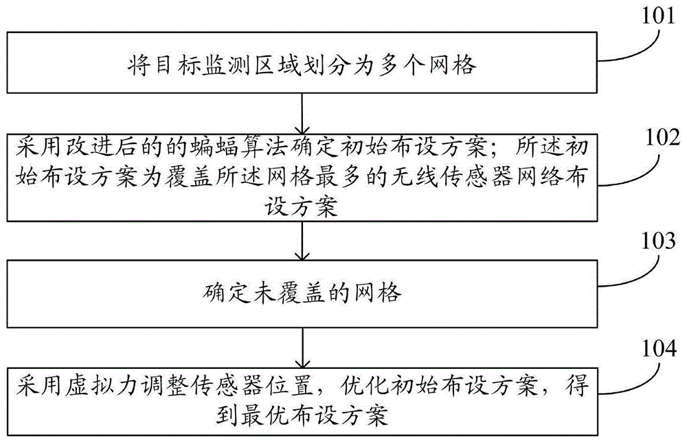
dividing a target monitoring area into a plurality of grids;
determining an initial layout scheme by adopting an improved bat algorithm; the initial layout scheme is a wireless sensor network layout scheme which covers the grids most;
determining an uncovered grid;
and adjusting the position of the sensor by adopting the virtual force, and optimizing the initial layout scheme to obtain an optimal layout scheme.
Further, the determining the initial layout scheme by using the improved bat algorithm specifically includes:
calculating the fitness value of each bat; each bat represents the layout scheme of the wireless sensor network, and the fitness value represents the coverage rate of the wireless sensor network;
selecting the bat corresponding to the maximum fitness value as the optimal bat;
updating the positions and speeds of all bats based on the optimal bats and the Levy flight disturbances;
calculating the fitness value of the bat after the position and speed are updated;
and selecting the corresponding bat as an initial laying scheme when the updated fitness value is maximum.
Further, the determining the uncovered grid specifically includes:
calculating the distance between each sensor and the grid;
and if the distance is larger than the monitoring radius of the sensor, determining that the current grid is an uncovered grid.
Further, the adjusting the position of the sensor by using the virtual force to optimize the initial layout scheme specifically includes:
calculating a virtual repulsive force between the ith sensor and an adjacent sensor;
calculating a virtual attraction between the ith sensor and the uncovered grid;
calculating a virtual force resultant force according to the virtual repulsive force and the virtual attractive force;
and adjusting the position of the ith sensor according to the virtual force resultant force.
Further, still include:
judging whether the coverage rate in the optimal layout scheme meets a preset condition or not;
if yes, outputting an optimal layout scheme;
if not, judging whether the iteration times of the improved bat algorithm reach the maximum reaching times or not;
if yes, outputting an optimal layout scheme;
the invention also provides a wireless sensor network coverage rate optimization system, which comprises:
the dividing module is used for dividing the target monitoring area into a plurality of grids;
the initial layout scheme determining module is used for determining an initial layout scheme by adopting an improved bat algorithm; the initial layout scheme is a wireless sensor network layout scheme which covers the grids most;
an uncovered grid determining module for determining uncovered grids;
and the adjusting module is used for adjusting the position of the sensor by adopting the virtual force, optimizing the initial layout scheme and obtaining an optimal layout scheme.
Further, the initial layout scheme determining module specifically includes:
the first fitness value calculating unit is used for calculating the fitness value of each bat; each bat represents the layout scheme of the wireless sensor network, and the fitness value represents the coverage rate of the wireless sensor network;
the first selection unit is used for selecting the corresponding bat as the optimal bat when the fitness value is maximum;
an updating unit for updating the positions and speeds of all bats based on the optimal bats and the Levy flight disturbances;
a second fitness value calculating unit for calculating a fitness value of the bat after position and speed updating;
and the second selection unit is used for selecting the corresponding bat as an initial laying scheme when the updated fitness value is maximum.
Further, the uncovered grid determining module specifically includes:
a distance calculation unit for calculating the distance between each sensor and the grid;
and the uncovered grid determining unit is used for determining that the current grid is an uncovered grid when the distance is greater than the monitoring radius of the sensor.
Further, the adjusting module specifically includes:
the virtual repulsion calculation unit is used for calculating the virtual repulsion between the ith sensor and the adjacent sensor;
a virtual gravity calculation unit for calculating a virtual gravity between the i-th sensor and the uncovered grid;
the virtual force resultant force calculation unit is used for calculating a virtual force resultant force according to the virtual repulsive force and the virtual attractive force;
and the adjusting unit is used for adjusting the position of the ith sensor according to the virtual force resultant force.
According to the specific embodiment provided by the invention, the invention discloses the following technical effects:
in the invention, a monitoring area is discretized into grid points, the coverage rate is used as an objective function value, the position of a sensor node is updated by using an improved bat algorithm, the wireless sensor coverage problem is converted into an objective function optimization problem by using the bat algorithm, and finally, the wireless sensor is secondarily deployed by using a virtual force algorithm on the basis of the improved bat algorithm, so that the network node is uniformly deployed, and the node coverage rate is increased. According to the method, the bat algorithm is improved by introducing inertia weight and Levy flight, and a virtual force algorithm is added, so that the global search capability of the algorithm is improved, and the network coverage rate is improved.
Detailed Description
The technical solutions in the embodiments of the present invention will be clearly and completely described below with reference to the drawings in the embodiments of the present invention, and it is obvious that the described embodiments are only a part of the embodiments of the present invention, and not all of the embodiments. All other embodiments, which can be derived by a person skilled in the art from the embodiments given herein without making any creative effort, shall fall within the protection scope of the present invention.
The invention aims to provide a method and a system for optimizing the coverage rate of a wireless sensor network, which can improve the global search capability of an algorithm and improve the network coverage rate.
In order to make the aforementioned objects, features and advantages of the present invention comprehensible, embodiments accompanied with figures are described in further detail below.
As shown in fig. 1-2, a method for optimizing coverage of a wireless sensor network includes the following steps:
step 101: the target monitoring area is divided into a plurality of grids.
Step 102: determining an initial layout scheme by adopting an improved bat algorithm; the initial layout scheme is a wireless sensor network layout scheme which covers the grids most. Specifically, the method comprises the following steps: calculating the fitness value of each bat; each bat represents the layout scheme of the wireless sensor network, and the fitness value represents the coverage rate of the wireless sensor network; selecting the bat corresponding to the maximum fitness value as the optimal bat; updating the positions and speeds of all bats based on the optimal bats and the Levy flight disturbances; calculating the fitness value of the bat after the position and speed are updated; and selecting the corresponding bat as an initial laying scheme when the updated fitness value is maximum.
Step 103: an uncovered grid is determined. Specifically, the method comprises the following steps: calculating the distance between each sensor and the grid; and if the distance is larger than the monitoring radius of the sensor, determining that the current grid is an uncovered grid.
Step 104: and adjusting the position of the sensor by adopting the virtual force, and optimizing the initial layout scheme to obtain an optimal layout scheme. Specifically, the method comprises the following steps: calculating a virtual repulsive force between the ith sensor and an adjacent sensor; calculating a virtual attraction between the ith sensor and the uncovered grid; calculating a virtual force resultant force according to the virtual repulsive force and the virtual attractive force; and adjusting the position of the ith sensor according to the virtual force resultant force.
After step 104, further comprising: judging whether the coverage rate in the optimal layout scheme meets a preset condition or not; if yes, outputting an optimal layout scheme; if not, judging whether the iteration times of the improved bat algorithm reach the maximum reaching times or not; if yes, outputting an optimal layout scheme;
the working principle of the method is described in detail as follows:
step one, establishing a model and initializing network parameters.
(1) And establishing a network model.
Assuming that the monitoring area is square, and the side length of the monitoring area is divided into m equal parts, the layout area is divided into m2Then the square monitoring area is discretized into K ═ m +1)2A grid of points. The coordinates of the K grid points are noted as the grid coordinate matrix SpotK×2As shown in equation 1. Where the Spotk,1、Spotk,2Respectively, as x, y coordinates of the kth grid point.
(2) Network parameters are initialized.
The monitoring radius of the initialized sensor is R, and the node type is a Boolean sensing model. The quantity of bat populations is set to be n, each bat represents a layout scheme containing D sensors, and the dimension is D. Setting a maximum number of iterations tmaxThe minimum and maximum values of the frequency of the search pulse are set to fmin,fmaxInitial loudness AiAnd a pulse frequency ri. Initializing the positions of D sensors, and recording the positions of D sensor nodes as positionsD×2As shown in equation 2. Wherein the Positioni,1、Positioni,2Respectively representing the x and y coordinates of the ith sensor node.
And step two, calculating the objective function value of each bat and outputting the uncovered point coordinates.
(1) The distance of each sensor from the grid point is calculated.
The distances of the respective sensors from the divided grid points are calculated according to formula 3. Then dikRepresenting the euclidean distance of the ith sensor to the kth grid point.
(2) And calculating the objective function value of each bat, and outputting uncovered point coordinates.
According to the steps 1-6, solving the network coverage Rate at the corresponding position of each bat, and setting the target function (namely the fitness value) of the bat as f ═ Rate. Specifically, the method comprises the following steps:
step 1, resetting a counter.
The counter is reset according to equation 4.
sum is 0 formula 4
And 2, calculating the distance.
Traversing K grid points, and for the grid point K, calculating the distance between the jth grid point and the ith sensor node according to formula 3, di,kRepresenting the euclidean distance of the ith sensor node to the kth grid point.
And 3, judging the coverage condition.
If d isi,k≤RiIf yes, then the kth grid point is covered, the counter is updated according to formula 5, and step 5 is performed;
sum +1 formula 5
If d isi,k>RiIf so, it is indicated that the kth grid point is uncovered, outputting uncovered grid point coordinates, and the counter is not updated, otherwise, performing step 4.
And 4, judging whether the N sensor nodes are traversed or not.
If all the N sensor nodes traverse, performing step 5; and if the N sensor nodes are not traversed completely, performing the step 2.
And 5: and judging whether the traversal of the K grid points is completed.
If the K grid points are traversed, performing step 6; and if the K grid points are not traversed, performing the step 2.
Step 6: and calculating the network coverage rate.
The network coverage of the current monitoring area is calculated according to equation 6.
It should be noted that for m equal division of the length and width of the monitoring area as described in the network model establishment, the following conclusions can be drawn:
the larger the value of m, the more dense the mesh division, the more the mesh points, the more accurate the network coverage efficiency calculated according to equation 6, but the worse the time complexity, generally, the m is 100.
And step three, updating the bat speed, the position, the pulse frequency and the sound intensity.
(1) And updating the bat position and speed.
Calculating and comparing the fitness value of each bat to obtain the optimal bat x*(t) and updating the positions and speeds of all bats by the optimal bats, wherein the updating formula is as follows:
fi(t)=fmin+(fmax-fmin) Beta equation 7
vi(t+1)=ω*vi(t)+(xi(t)-x*(t))fi(t) formula 8
In formula 7, fi(t) is the emitting frequency of the ith bat in the t wheel, fminAnd fmaxRespectively, the minimum and maximum of the emission frequency, beta ∈ [0,1 ]]I.e. beta is a random value subject to uniform distribution, vi(t) is the flight speed of the ith bat in t wheel, xi(t) is the position of the ith bat at t rounds, x*Is the optimal bat position.
The bat algorithm is a special particle swarm algorithm, and in order to strengthen the global search capability and accelerate the convergence speed, the invention introduces a weight coefficient omega in a bat speed updating formula, specifically see formula 9.
T in equation 9maxIs the maximum number of iterations, ωiniIs the initial weight value, ωfinIs the final weight value.
xi(t+1)=xi(t)+vi(t) equation 10
While updating the bat global position according to equation 10.
(2) Updating the loudness and pulse frequency of the bat.
For the optimal bat, the invention introduces a Levy flight disturbance updating mode to update the bat position and update the bat loudness and pulse frequency. The update strategy is as follows:
1) generating a random number rand
1If r is
i<rand
1(r
iPulse frequency of ith bat), then
To find a new optimal solution
The location is updated according to
equation 11, and vice versa (2) is performed.
2) Generating a random number rand
2If A is
i(t)>rand
2(A
i(t) is the pulse intensity of the ith bat), and
and moving to the updated position, and otherwise, performing the step four.
3) When the condition of the step 2) is met, updating the transmitting pulse frequency and the sound intensity A:
wherein t is the iteration number, gamma is the pulse frequency increasing coefficient, and alpha is the pulse sound intensity attenuation coefficient.
(3) And updating the bat fitness value.
Calculating the fitness value after updating the bat position and speed, obtaining the Euclidean distance between the sensor node and the grid point according to a formula 3, comparing the Euclidean distance with the monitoring radius of the sensor node, and outputting the uncovered grid point coordinate No _ cover if the Euclidean distance is larger than the monitoring radius. (according to formula 3, the Euclidean distance between the sensor nodes and the grid points is obtained and compared with the monitoring radius of the sensor nodes, specifically, in the step 1 to the step 3 in the step two, the coordinates of all the sensor nodes and the coordinates of the grid points are input, the coordinates of uncovered grid points are output, and the more uncovered grid points, the lower the adaptability value, namely the coverage rate is.)
And step four, performing secondary deployment by using the virtual force.
After the position is updated by using the bat algorithm, initial layout is formed, secondary deployment is carried out by continuously adopting virtual force between the nodes and uncovered grid points and virtual force between the nodes, and the coverage rate is further improved.
The method comprises the following specific steps:
step 1: uncovered grid point coordinates No cover in input 2.
Step 2: any two sensor nodes skAnd slThe virtual repulsive force experienced may be expressed as:
in formula 14,. omegailIs the virtual repulsion coefficient from node to node. dilAs distance from node to node,dthIs a set distance threshold; thetailDenoted as node siTo slThe azimuth of (d); riIs the sensing radius of the sensor.
Sensor node siVirtual gravity on uncovered grid:
in formula 15,. omegaikThe virtual gravitation coefficients of the nodes and the uncovered grids; dikIs the distance between the node and the uncovered grid; riTo set the distance threshold, thetaklDenoted as node siTo uncovered grid points spotkIs measured.
Then node siThe resultant virtual forces generated by the adjacent node and the uncovered grid are as follows:
Fi=F(si,sl)+F(si,spotk) Equation 16
And step 3: suppose that the ith sensor node is subjected to the total force of
Resultant forces in the horizontal direction and the vertical direction are respectively
Moving sensor node i according to equation 17 (moving sensor node according to
equation 17, where position is the coordinates of the sensor, better coverage is obtained with the moving sensor node.)
And step five, judging whether the condition 1 of algorithm termination is met.
If the network coverage Rate satisfies that the Rate is more than or equal to Q (Q represents a preset condition), the coverage task is completed, and the algorithm is ended; otherwise, go to step six.
And step six, judging whether the condition 2 of algorithm termination is met.
Judging the current iteration round t and the maximum iteration number tmaxIf t > t is satisfiedmaxIf yes, the covering task is completed, and the algorithm is ended; otherwise, performing the third step in step 4.
The following describes the boolean sensing model of the sensor nodes in detail:
the boolean sensing model is a circular sensing area with a node i as the center and R as the radius, the sensing radius also becomes a sensing circle and can be covered by the node only when the sensing area falls within, and the model is also called a 0-1 model, and the mathematical expression of the model is shown in formula 18.
Wherein d (i, j) is the Euclidean distance between the node i and the target point j, and R is the node perception radius. Grid point MjMay be sensed by multiple sensors, so grid point MjThe joint probability perceived by the set of sensor nodes S ═ S1, S2
The network coverage is described in detail below:
the network model in the second step can obtain that the monitoring area is discretized into K ═ m +1)2One grid point, an arbitrary grid point MjQuilt node siThe perception probability can be calculated by formula (18), target point MjThe joint probability perceived by the set of sensor nodes S { S1, S2., sN } may be calculated by equation (19). The network coverage efficiency of the monitoring area is the ratio of the number of target points covered by all sensor nodes to the number of coverable grid points of the sensors in a state of not generating redundancy. The side length of the grid point is 1, so the number of the points covered by the sensor can be regarded as the area value of the sensor. The network coverage efficiency of the whole network is shown as formula 20As shown.
The virtual force algorithm vfa (virtual forcealgorithm) is described in detail below:
the virtual force algorithm originates from a virtual potential field, is used for avoiding obstacles in the moving process of the robot at first and is introduced into a WSN node deployment strategy at later time to optimize network coverage. By virtualizing the moving sensor node as a charged particle and assuming that there is a distance threshold DthWhen the distance between the two particles is larger than the threshold value, the acting force between the particles is the attractive force; when the distance between the particles is smaller than the threshold value, the acting force between the particles is a repulsive force, which is specifically shown in formula 21. Through the guidance of virtual acting force, the network can realize the effective coverage of the area through the distance adjustment between the nodes, and the coverage effect meeting the deployment requirement is achieved through reasonable threshold setting.
Wherein, ω is
α,ω
γRespectively are virtual force attraction force and repulsion force parameters; d
thIs a set distance threshold; alpha is alpha
ijIs the direction included angle between the two nodes,
representing the force of sensing node j against sensing node i.
Levy flight is described in detail below:
many animals in nature find their food in uncertain environments, the most desirable way being to use the "Levy flight" search strategy, which involves both exploratory short-distance bounces and occasional long-distance walks. Short-range jumping can ensure small-range careful search, and occasional long-distance walking can ensure that the robot enters another area to explore in a wider area. Therefore, many scholars introduce Levy flight into the evolutionary algorithm to obtain better effect.
When calculating the search path of the Levy flight, Levy (λ) usually adopts a calculation formula proposed by Mantegna to simulate the Levy flight path:
Levy(λ)=μ/|v|1/β equation 22
In equation 22: the value range of the parameter beta is more than 0 and less than 2, generally 1.5 is taken, and the parameters mu and v are normal distribution random numbers and obey normal distribution shown in a formula 23; the standard deviation σ of the normal distribution corresponding to the formula (23)μ、σvSatisfies formula 24.
The method provided by the invention has the following advantages:
(1) improves the global search capability of the bat algorithm, and avoids premature trapping into local optimum
The speed and position of the bat algorithm are updated, a weight strategy is introduced during global position updating, the global searching capability of the bat algorithm is enhanced, Levy flight is introduced during local position updating, the problem that the algorithm falls into a local optimal solution too early is avoided, and the problem that the bat algorithm in a similar paper is poor in global searching capability and falls into the local optimal solution too early due to position updating, so that the coverage rate cannot be further improved. Fig. 3 is a coverage map of two algorithms applied to a wireless sensor network, (a) is the algorithm of the present invention, and (b) is the original bat algorithm. The node distribution of the improved bat algorithm is more uniform, the coverage rate is larger, and the improvement is about 11.8%.
(2) Compared with the original virtual force algorithm, the coverage rate is improved
The virtual force is utilized for secondary deployment, the improved bat algorithm is used as initial coverage, on the basis of the improved bat algorithm, the improved virtual force is used, and the original virtual force algorithm is optimized. As shown in FIG. 4, (a) is the algorithm of the invention, and (b) is the algorithm of the original virtual force, the virtual attraction which does not cover the grid points and the virtual repulsion between the sensor nodes are introduced, compared with the algorithm of the original virtual force, the final coverage rate of the network of the invention scheme of the invention is higher, and is improved by about 6.2%.
The algorithm is obviously improved by the mode of experimental simulation, and as can be seen from fig. 5, the final coverage rate of the invention can reach about 91.5%, the improved virtual force algorithm can reach about 83.4%, the traditional bat algorithm can reach about 77.6%, and the improved bat algorithm can reach about 80.3%, because compared with the above algorithm, the algorithm is divided into two stages, the first stage uses the improved bat algorithm, and then introduces the virtual attraction of uncovered grid points and the repulsion between sensors, and carries out secondary deployment, so that the coverage rate is improved by about 11.2% compared with the improved bat algorithm, is improved by about 13.9% compared with the traditional bat algorithm, and is improved by about 8.1% compared with the improved virtual force algorithm.
The invention also provides a wireless sensor network coverage rate optimization system, which comprises:
the dividing module is used for dividing the target monitoring area into a plurality of grids;
the initial layout scheme determining module is used for determining an initial layout scheme by adopting an improved bat algorithm; the initial layout scheme is a wireless sensor network layout scheme which covers the grids most;
an uncovered grid determining module for determining uncovered grids;
and the adjusting module is used for adjusting the position of the sensor by adopting the virtual force, optimizing the initial layout scheme and obtaining an optimal layout scheme.
The initial layout scheme determining module specifically includes:
the first fitness value calculating unit is used for calculating the fitness value of each bat; each bat represents the layout scheme of the wireless sensor network, and the fitness value represents the coverage rate of the wireless sensor network;
the first selection unit is used for selecting the corresponding bat as the optimal bat when the fitness value is maximum;
an updating unit for updating the positions and speeds of all bats based on the optimal bats and the Levy flight disturbances;
a second fitness value calculating unit for calculating a fitness value of the bat after position and speed updating;
and the second selection unit is used for selecting the corresponding bat as an initial laying scheme when the updated fitness value is maximum.
Wherein the uncovered grid determining module specifically includes:
a distance calculation unit for calculating the distance between each sensor and the grid;
and the uncovered grid determining unit is used for determining that the current grid is an uncovered grid when the distance is greater than the monitoring radius of the sensor.
Wherein, the adjusting module specifically comprises:
the virtual repulsion calculation unit is used for calculating the virtual repulsion between the ith sensor and the adjacent sensor;
a virtual gravity calculation unit for calculating a virtual gravity between the i-th sensor and the uncovered grid;
the virtual force resultant force calculation unit is used for calculating a virtual force resultant force according to the virtual repulsive force and the virtual attractive force;
and the adjusting unit is used for adjusting the position of the ith sensor according to the virtual force resultant force.
The embodiments in the present description are described in a progressive manner, each embodiment focuses on differences from other embodiments, and the same and similar parts among the embodiments are referred to each other. For the system disclosed by the embodiment, the description is relatively simple because the system corresponds to the method disclosed by the embodiment, and the relevant points can be referred to the method part for description.
The principle and the implementation mode of the invention are explained by applying a specific example, and the description of the embodiment is only used for helping to understand the method and the core idea of the invention; meanwhile, for a person skilled in the art, according to the idea of the present invention, the specific embodiments and the application range may be changed. In view of the above, the present disclosure should not be construed as limiting the invention.