CN115683092A - DME/DME/SINS tightly-combined navigation system relocation method - Google Patents
DME/DME/SINS tightly-combined navigation system relocation method Download PDFInfo
- Publication number
- CN115683092A CN115683092A CN202110877439.2A CN202110877439A CN115683092A CN 115683092 A CN115683092 A CN 115683092A CN 202110877439 A CN202110877439 A CN 202110877439A CN 115683092 A CN115683092 A CN 115683092A
- Authority
- CN
- China
- Prior art keywords
- dme
- sins
- navigation
- attitude
- error
- Prior art date
- Legal status (The legal status is an assumption and is not a legal conclusion. Google has not performed a legal analysis and makes no representation as to the accuracy of the status listed.)
- Granted
Links
Images


Landscapes
- Navigation (AREA)
Abstract
Description
技术领域technical field
本发明涉及一种在高动态、弱信号等工作环境下,载体在飞行过程中DME/DME/SINS紧组合导航系统的快速重定位技术。The invention relates to a rapid relocation technology of a DME/DME/SINS tight integrated navigation system during the flight of a carrier under high dynamic, weak signal and other working environments.
背景技术Background technique
随着导航技术的不断发展,对导航系统精度、稳定性等方面的要求越来越高。现代航空事业涉及到的技术越来越多,也越来越复杂,飞机不再是简单的交通工具,而是多项技术的集合体,单一导航系统的性能存在一定的局限性,其往往无法满足特殊环境下的定位要求。组合导航系统可以充分发挥各个系统的优势,使各导航系统优势互补,从而在保证整个系统的精度的同时提高系统的稳定性,鉴于这种优势,组合导航系统得到了快速发展。其中,捷联惯性导航系统(SINS)和GNSS组合导航系统的应用最为广泛。由于GNSS存在动态响应能力较差,易受电子干扰,信号易被遮挡以及完好性较差的缺点,GNSS信号在某些特殊环境下质量较差,在这种情况下,GNSS/SINS组合导航无法正常工作,系统进入纯SINS解算工作模式,由于惯性器件测量误差等误差源的存在,其导航定位误差随时间积累,依靠SINS独立工作无法满足长时间导航的需求。因而亟需设计GNSS/SINS组合导航系统的备份导航系统,以满足在GNSS拒止条件下飞机航路导航的需求。With the continuous development of navigation technology, the requirements for the accuracy and stability of the navigation system are getting higher and higher. Modern aviation industry involves more and more technologies, and they are becoming more and more complex. Aircraft is no longer a simple means of transportation, but a collection of multiple technologies. There are certain limitations in the performance of a single navigation system, which often cannot Meet the positioning requirements in special environments. The integrated navigation system can give full play to the advantages of each system and make the advantages of each navigation system complement each other, so as to ensure the accuracy of the whole system and improve the stability of the system. In view of this advantage, the integrated navigation system has been developed rapidly. Among them, strapdown inertial navigation system (SINS) and GNSS integrated navigation system are the most widely used. Due to the shortcomings of GNSS, such as poor dynamic response capability, susceptibility to electronic interference, signal occlusion and poor integrity, the quality of GNSS signals is poor in some special environments. In this case, GNSS/SINS integrated navigation cannot Normal operation, the system enters the pure SINS calculation mode. Due to the existence of error sources such as inertial device measurement errors, its navigation and positioning errors accumulate over time, and relying on SINS to work independently cannot meet the needs of long-term navigation. Therefore, it is urgent to design a backup navigation system of the GNSS/SINS integrated navigation system to meet the needs of aircraft route navigation under GNSS denial conditions.
陆基无线电导航系统是国际通用的民航导航系统,是民航组织与实施飞行,进行安全生产和经营管理的基础系统。陆基无线电导航系统定位精度比较差,但其信号发射功率大,具有不易受干扰、数据更新率较高等卫星导航系统所不具备的优点。测距机(DME)是一种高精度的非自主式时间测距近程导航系统,是民用航空重要的陆基测距导航系统,可为飞机提供到DME台的斜距。DME测距仪采用的是询问—应答式测距法,其为全世界民航的通用测距引导设备,它既可用作航线导航设备,也可用作机场导航设备。DME通过测量电波在空间的传播时间来获取距离信息,测距过程分为搜索、跟踪和记忆阶段。DME系统由机载询问器和地面应答器两部分组成,通过准确测量收发信号总时间以及地面应答部分的固定延时,计算飞机至地面DME台的距离信息。在基于性能的导航应用中DME/DME导航被广泛应用于航路导航阶段。DME/DME导航属于定位方式,基于DME测量斜距的有界性,DME/DME的定位误差也是有界的。惯导系统是以装配的三轴陀螺仪和加速度计为敏感器件的导航参数解算系统,该系统根据陀螺的输出建立起导航坐标系,根据加速度计的输出解算出运载体的速度和位置。根据构建导航坐标系方法的不同可将惯导系统分为平台式和捷联式两种,其中采用数学算法确定出导航坐标系的系统称为捷联惯导系统,即SINS。当GNSS信号在特殊环境受到干扰质量下降时,GNSS/SINS组合导航系统导航精度下降,无法满足航路导航的需求。The ground-based radio navigation system is an international civil aviation navigation system, and it is the basic system for civil aviation organization and implementation of flight, safety production and operation management. The positioning accuracy of the land-based radio navigation system is relatively poor, but its signal transmission power is large, and it has the advantages that the satellite navigation system does not have, such as being less susceptible to interference and having a higher data update rate. The distance measuring machine (DME) is a high-precision non-autonomous time-ranging short-range navigation system. It is an important ground-based ranging navigation system for civil aviation. It can provide aircraft with a slant distance to the DME station. The DME rangefinder adopts the query-response distance measurement method, which is a general ranging guidance equipment for civil aviation all over the world. It can be used as both route navigation equipment and airport navigation equipment. DME obtains distance information by measuring the propagation time of radio waves in space. The ranging process is divided into search, tracking and memory stages. The DME system consists of two parts: the airborne interrogator and the ground transponder. By accurately measuring the total time of sending and receiving signals and the fixed delay of the ground response part, the distance information from the aircraft to the ground DME station is calculated. DME/DME navigation is widely used in the en-route navigation stage in performance-based navigation applications. DME/DME navigation is a positioning method. Based on the boundedness of the slant distance measured by DME, the positioning error of DME/DME is also bounded. The inertial navigation system is a navigation parameter calculation system based on the assembled three-axis gyroscope and accelerometer as sensitive devices. The system establishes a navigation coordinate system based on the output of the gyroscope, and calculates the velocity and position of the carrier based on the output of the accelerometer. According to the different methods of constructing the navigation coordinate system, the inertial navigation system can be divided into two types: platform type and strapdown type. Among them, the system that uses mathematical algorithms to determine the navigation coordinate system is called strapdown inertial navigation system, or SINS. When the GNSS signal is interfered in a special environment and the quality decreases, the navigation accuracy of the GNSS/SINS integrated navigation system decreases, which cannot meet the needs of route navigation.
当前国内民航客机大部分装配国外生产的飞行管理系统,其中部分型号的飞行管理系统已经具备DME/DME/SINS组合导航功能,但其具体技术细节无法得知,亦很难查找到相关的技术资料。国内针对DME/DME/SINS组合导航系统开展的研究较少,仅有一篇文献对其展开了研究。在有高度参考的条件下,将组合导航问题简化为二维平面组合导航。显然由于将地球局部简化为平面,在状态空间模型的建模层面上带来了原理性误差,该原理性误差将直接影响导航精度,因而该研究实际应用价值不大。综上所述,有必要对这一具备广阔应用前景的组合导航系统开展更为深入的研究。研究DME/DME/SINS组合导航系统,最简单直接的方式是将DME/DME定位的位置结果与SINS解算的位置作差形成量测信息,以SINS误差传播方程为基础建立卡尔曼滤波状态空间模型,进而通过卡尔曼滤波器对系统的导航误差进行估计和补偿以实现组合导航。这种组合方式通常称为松组合导航模式,该模式与GNSS/SINS松组合模式完全一致,其优点在于实现方式简单,存在的问题是算法导航精度不够高且在有突变量测噪声干扰的条件下其导航精度损失严重,甚至在一定时间内无法满足导航需求,因此松组合导航模式并不是DME/DME/SINS组合导航理想的工作模式。为解决松组合存在的问题,大量研究者针对组合导航信息融合的滤波算法开展了大量的研究,然而所提出的相关滤波算法虽然可在理论层面上一定程度改进组合导航系统的性能,但却带来了其他的问题:其一,为保证滤波算法的效果,滤波初始参数的设置极为严苛;其二,改进的滤波算法大幅度增加了运算量,这对于算法运行的实时性提出了新的挑战。因而通过改进滤波算法优化松组合导航系统性能的策略在实际应用中的可行性仍需进行大量的验证。除滤波算法的研究外,部分研究者将故障诊断与隔离的有关方法应用到松组合导航系统中,如小波变换、M估计等,这类方法在算法运行的实时性上同样存在问题。At present, most domestic civil aviation aircraft are equipped with foreign-made flight management systems, and some models of flight management systems already have DME/DME/SINS integrated navigation functions, but the specific technical details are unknown, and it is difficult to find relevant technical information . There are few researches on DME/DME/SINS integrated navigation system in China, and there is only one literature on it. Under the condition of height reference, the integrated navigation problem is reduced to two-dimensional planar integrated navigation. Apparently, the partial simplification of the earth into a plane brings a principle error at the modeling level of the state space model, which will directly affect the navigation accuracy, so the practical application value of this research is not great. To sum up, it is necessary to carry out more in-depth research on this integrated navigation system with broad application prospects. The simplest and direct way to study DME/DME/SINS integrated navigation system is to make the difference between the position result of DME/DME positioning and the position calculated by SINS to form measurement information, and establish the Kalman filter state space based on the SINS error propagation equation The model is used to estimate and compensate the navigation error of the system through the Kalman filter to realize integrated navigation. This combination method is usually called the loose combination navigation mode, which is completely consistent with the GNSS/SINS loose combination mode. Its advantage is that the implementation method is simple, but the existing problems are that the algorithm navigation accuracy is not high enough and there is a mutation measurement noise interference condition However, the navigation accuracy is seriously lost, and even the navigation requirements cannot be met within a certain period of time. Therefore, the loose integrated navigation mode is not an ideal working mode for DME/DME/SINS integrated navigation. In order to solve the problems of loose combination, a large number of researchers have carried out a lot of research on the filtering algorithm of integrated navigation information fusion. There are other problems: first, in order to ensure the effect of the filtering algorithm, the setting of the initial filtering parameters is extremely strict; second, the improved filtering algorithm greatly increases the amount of computation, which poses new challenges for the real-time performance of the algorithm. challenge. Therefore, the feasibility of the strategy of optimizing the performance of the loosely integrated navigation system by improving the filtering algorithm in practical applications still needs a lot of verification. In addition to the research on filtering algorithms, some researchers have applied related methods of fault diagnosis and isolation to loosely integrated navigation systems, such as wavelet transform, M estimation, etc. These methods also have problems in the real-time performance of the algorithm.
紧组合导航模式是GNSS/SINS组合导航系统在实际中应用最多的工作模式,亦可采用紧组合模式设计DME/DME/SINS组合导航系统。相对于采用外部位置或速度辅助的松组合模式,紧组合采用更深层次的观测量形成量测信息,如伪距和伪距率等。由于采用更深层次的观测量进行组合,紧组合工作模式下的组合导航系统的抗干扰能力更强,在实际应用中的导航精度更高。然而,直接借鉴GNSS/SINS紧组合导航模式无法设计DME/DME/SINS紧组合导航系统,原因在于前者的组合方式往往还需要利用伪距率这一外部观测信息,而对于后者而言,在组合过程中没有伪距率这类量测信息。针对DME/DME/SINS紧组合导航系统,仅依靠两个伪距观测信息无法实现组合导航,结合实际机载导航设备,大气数据机提供的机载高度信息可作为额外的观测信息,将其与双伪距观测信息一道可以辅助SINS实现紧组合导航。DME/DME/SINS组合导航系统主要通过建立卡尔曼滤波状态方程和量测方程、卡尔曼滤波状态估计和导航参数误差校正模式等三个方面来抑制SINS随时间积累的导航误差。The tight integrated navigation mode is the most widely used working mode of the GNSS/SINS integrated navigation system, and the tight integrated mode can also be used to design the DME/DME/SINS integrated navigation system. Compared with the loose combination mode that uses external position or velocity assistance, the tight combination uses deeper observations to form measurement information, such as pseudorange and pseudorange rate. Due to the combination of deeper observations, the integrated navigation system in the tight combination mode has stronger anti-interference ability and higher navigation accuracy in practical applications. However, it is impossible to design a DME/DME/SINS tight integrated navigation system by directly referring to the GNSS/SINS tight integrated navigation mode. There is no measurement information such as pseudorange rate during the combination process. For the DME/DME/SINS tight integrated navigation system, integrated navigation cannot be realized only by relying on two pseudo-range observation information. Combined with the actual airborne navigation equipment, the airborne altitude information provided by the air data machine can be used as additional observation information, which can be combined with The dual pseudo-range observation information together can assist SINS to realize tight integrated navigation. The DME/DME/SINS integrated navigation system suppresses the navigation error accumulated by SINS over time by establishing Kalman filter state equation and measurement equation, Kalman filter state estimation and navigation parameter error correction mode.
综上所述,鉴于国内针对DME/DME/SINS组合导航系统开展的研究较少,同时考虑到DME/DME/SINS作为GNSS/SINS组合导航系统的备份具有重要的应用前景,有必要对其展开系统的研究。在实现过程中,考虑到系统的工程实现难度以及组合导航系统的抗干扰能力和导航精度,应针对DME/DME/SINS组合导航系统的紧组合导航模式开展深入研究。To sum up, in view of the lack of research on DME/DME/SINS integrated navigation system in China, and considering that DME/DME/SINS has important application prospects as the backup of GNSS/SINS integrated navigation system, it is necessary to carry out research on it. Systematic research. In the process of realization, considering the difficulty of engineering realization of the system and the anti-interference ability and navigation accuracy of the integrated navigation system, in-depth research should be carried out on the tight integrated navigation mode of the DME/DME/SINS integrated navigation system.
发明内容Contents of the invention
为了保证GNSS拒止条件下机载导航系统的导航精度,本发明提供一种具备抗干扰能力、能够满足导航实时性和可靠性要求的DME/DME/SINS紧组合导航方案,旨在保证GNSS拒止条件下,为GNSS/SINS组合导航系统提供可靠的备份导航系统,确保飞机航路飞行阶段的飞航安全。In order to ensure the navigation accuracy of the airborne navigation system under GNSS denial conditions, the present invention provides a DME/DME/SINS tight integrated navigation solution with anti-jamming capability and capable of meeting navigation real-time and reliability requirements, aiming at ensuring GNSS denial Provide a reliable backup navigation system for the GNSS/SINS integrated navigation system to ensure the flight safety of the aircraft during flight.
本发明的上述目的可以通过以下措施来得到,一种DME/DME/SINS紧组合导航系统重定位方法,其特征在于包括如下步骤:以指北方位SINS姿态误差方程、速度误差方程和位置误差方程为基础,基于三轴姿态误差、东北天方向的速度误差、位置误差、陀螺常值漂移和加速度计常值零偏为状态变量,建立卡尔曼滤波的状态方程;根据捷联惯性导航系统SINS解算的位置,计算飞机至测距机DME双台站的伪斜距,将DME机载测量设备测量的斜距与伪斜距作差形成斜距量测信息,将大气数据机测量的高度与SINS输出的高度作差形成高度量测信息;推导量测信息与状态变量间的转换关系,建立卡尔曼滤波量测方程;根据惯性器件输出的测量值进行SINS导航解算,输出导航参数;在DME输出的斜距和大气数据机高度两类导航信息的辅助下,通过卡尔曼滤波器实现对系统状态变量的实时估计,卡尔曼滤波器采用反馈校正的策略,反馈校正姿态误差、速度误差和位置误差,对SINS导航误差进行实时校正,确定飞机最终的位置、速度和姿态,将卡尔曼滤波状态方程和量测方程的建立、量测信息的计算、以及卡尔曼滤波状态估计和反馈校正进行综合,得到DME/DME/SINS紧组合导航系统导航传感器数据采集、数据处理、信息融合和重定位的结果,利用估计得到的姿态、速度和位置误差反馈校正SINS姿态、速度和位置,以此抑制SINS导航误差,输出更高精度的导航信息,并显示。The above-mentioned purpose of the present invention can be obtained by the following measures, a kind of DME/DME/SINS tightly integrated navigation system relocation method is characterized in that comprising the steps: to point to the north position SINS attitude error equation, speed error equation and position error equation Based on the three-axis attitude error, the speed error in the northeast sky direction, the position error, the gyro constant drift and the accelerometer constant zero bias as state variables, the state equation of the Kalman filter is established; according to the SINS solution of the strapdown inertial navigation system calculate the pseudo-slant distance from the aircraft to the DME dual stations of the rangefinder, make a difference between the slant distance measured by the DME airborne measuring equipment and the pseudo-slant distance to form the slant distance measurement information, and compare the height measured by the air data machine with the pseudo-slant distance The altitude output by SINS is made to form altitude measurement information; the conversion relationship between measurement information and state variables is deduced, and the Kalman filter measurement equation is established; SINS navigation calculation is performed according to the measurement value output by the inertial device, and the navigation parameters are output; With the assistance of two types of navigation information, the slant distance output by the DME and the altitude of the air data machine, the real-time estimation of the system state variables is realized through the Kalman filter. The Kalman filter uses a feedback correction strategy to feedback and correct the attitude error, velocity error and Position error, real-time correction of SINS navigation error, determination of the final position, speed and attitude of the aircraft, establishment of Kalman filter state equation and measurement equation, calculation of measurement information, and Kalman filter state estimation and feedback correction. Synthesis, get the results of DME/DME/SINS tight integrated navigation system navigation sensor data acquisition, data processing, information fusion and relocation, use the estimated attitude, velocity and position error feedback to correct the SINS attitude, velocity and position, so as to suppress SINS navigation error, output higher precision navigation information, and display.
本发明具有如下有益效果:The present invention has following beneficial effects:
本发明针对DME/DME/SINS紧组合导航系统,暂无完备的可在实际应用中实施的方案,采用DME/DME代替GNSS,利用SINS较好的误差平滑特性,有效地平滑了DME/DME定位误差。The present invention is aimed at the DME/DME/SINS tight combination navigation system, and there is no complete solution that can be implemented in practical applications. DME/DME is used instead of GNSS, and the better error smoothing characteristics of SINS are used to effectively smooth the DME/DME positioning error.
本发明以DME+DME+SINS紧组合导航方案,理论框架完备、算法内容简单可靠,改善了GNSS拒止条件下机载导航系统性能,为后续DME/DME/SINS组合导航方案的进一步研究奠定了基础。The present invention uses the DME+DME+SINS combined navigation scheme with a complete theoretical framework and simple and reliable algorithm content, which improves the performance of the airborne navigation system under GNSS denial conditions and lays the foundation for further research on the subsequent DME/DME/SINS combined navigation scheme. Base.
系统具备较强的抗干扰能力和较高的导航精度。本发明所设计的DME/DME/SINS组合导航方案采用紧组合导航模式。相较于采用DME/DME通过定位方式得到飞机位置,再将该位置与SINS解算的位置作差形成量测信息的松组合导航模式,本发明由于采用更深层次的斜距和伪斜距作差形成量测信息的紧组合模式,在实际应用中具备更强的抗干扰能力和更高的导航精度。The system has strong anti-interference ability and high navigation accuracy. The DME/DME/SINS integrated navigation scheme designed by the present invention adopts a tight integrated navigation mode. Compared with using DME/DME to obtain the position of the aircraft through positioning, and then making a difference between the position and the position calculated by SINS to form the loose combination navigation mode of measurement information, the present invention uses deeper slant distance and pseudo-slope distance as The difference forms a tight combination mode of measurement information, which has stronger anti-interference ability and higher navigation accuracy in practical applications.
为GNSS/SINS组合导航系统提供了重要备份。本发明所提出的DME/DME/SINS组合导航方案的执行与GNSS/SINS组合导航系统完全独立,在GNSS信号良好的条件下,可参考GNSS/SINS组合导航系统给出的导航结果,在GNSS信号拒止的条件下,DME/DME/SINS组合导航系统可为GNSS/SINS组合导航系统提供重要备份,满足GNSS拒止条件下飞机航路飞行阶段的飞航安全。Provides an important backup for the GNSS/SINS integrated navigation system. The execution of the DME/DME/SINS integrated navigation scheme proposed by the present invention is completely independent of the GNSS/SINS integrated navigation system. Under the condition that the GNSS signal is good, the navigation result provided by the GNSS/SINS integrated navigation system can be referred to. Under the condition of denial, the DME/DME/SINS integrated navigation system can provide an important backup for the GNSS/SINS integrated navigation system, and meet the flight safety of the aircraft route flight stage under the condition of GNSS denial.
利用本发明可以实现SINS与DME输出导航数据的信息融合,提高组合导航系统的抗干扰能力和导航精度,为GNSS信号拒止条件下的GNSS/SINS组合导航系统提供重要的备份。The invention can realize information fusion of navigation data output by SINS and DME, improve the anti-jamming ability and navigation precision of the integrated navigation system, and provide important backup for the GNSS/SINS integrated navigation system under the condition of GNSS signal rejection.
本发明适用于飞航过程中飞机应用DME双台、大气数据机和惯性器件输出的原始数据进行导航信息融合,可以有效地实现DME/DME/SINS组合导航,所设计的方案对外依赖度低、抗干扰能力强。具备较强的抗干扰能力和较高的导航精度,可作为GNSS拒止条件下GNSS/SINS组合导航系统的重要备份,为航路飞行阶段提供可靠的导航信息。The present invention is suitable for the navigation information fusion of the original data output by DME dual sets, atmospheric data machine and inertial device, which can effectively realize DME/DME/SINS combined navigation, and the designed scheme has low external dependence and Strong anti-interference ability. With strong anti-interference ability and high navigation accuracy, it can be used as an important backup of GNSS/SINS integrated navigation system under GNSS denial conditions, providing reliable navigation information for the en route flight phase.
附图说明Description of drawings
下面结合附图和实施例对本发明作进一步说明。The present invention will be further described below in conjunction with drawings and embodiments.
图1是本发明DME/DME/SINS紧组合导航方案的原理示意图;Fig. 1 is the schematic diagram of the principles of the DME/DME/SINS tight combined navigation scheme of the present invention;
图2是本发明执行DME/DME/SINS紧组合导航方案的场景示意图。Fig. 2 is a schematic diagram of a scenario in which the DME/DME/SINS tight integrated navigation solution is implemented in the present invention.
具体实施方式Detailed ways
参阅图1、图2。根据本发明,以指北方位SINS姿态误差方程、速度误差方程和位置误差方程为基础,基于三轴姿态误差、东北天方向的速度误差、位置误差、陀螺常值漂移和加速度计常值零偏为状态变量,建立卡尔曼滤波的状态方程;根据捷联惯性导航系统SINS解算的位置,计算飞机至测距机DME双台站的伪斜距,将DME机载测量设备测量的斜距与伪斜距作差形成斜距量测信息,将大气数据机测量的高度与SINS输出的高度作差形成高度量测信息;推导量测信息与状态变量间的转换关系,建立卡尔曼滤波量测方程;根据惯性器件输出的测量值进行SINS导航解算,输出导航参数;在DME输出的斜距和大气数据机高度两类导航信息的辅助下,通过卡尔曼滤波器实现对系统状态变量的实时估计,卡尔曼滤波器采用反馈校正的策略,反馈校正姿态误差、速度误差和位置误差,对SINS导航误差进行实时校正,确定飞机最终的位置、速度和姿态,将卡尔曼滤波状态方程和量测方程的建立、量测信息的计算、以及卡尔曼滤波状态估计和反馈校正进行综合,得到DME/DME/SINS紧组合导航系统导航传感器数据采集、数据处理、信息融合和重定位的结果,利用估计得到的姿态、速度和位置误差反馈校正SINS姿态、速度和位置,以此抑制SINS导航误差,输出更高精度的导航信息,并显示。Refer to Figure 1 and Figure 2. According to the present invention, based on the north position SINS attitude error equation, speed error equation and position error equation, based on the three-axis attitude error, the speed error in the northeast sky direction, the position error, the gyro constant value drift and the accelerometer constant value zero offset As the state variable, the state equation of the Kalman filter is established; according to the position solved by the strapdown inertial navigation system SINS, the pseudo-slant distance from the aircraft to the DME dual station of the rangefinder is calculated, and the slope distance measured by the DME airborne measuring equipment is compared with the The pseudo slant distance difference forms the slant distance measurement information, and the height measured by the air data machine and the height output by the SINS are compared to form the height measurement information; the conversion relationship between the measurement information and the state variable is derived, and the Kalman filter measurement is established Equation; SINS navigation calculation is performed according to the measurement value output by the inertial device, and the navigation parameters are output; with the assistance of the two types of navigation information output by the DME, the slant distance and the altitude of the air data machine, the real-time control of the system state variables is realized through the Kalman filter. Estimation, the Kalman filter adopts the strategy of feedback correction, feedback corrects the attitude error, velocity error and position error, corrects the SINS navigation error in real time, determines the final position, velocity and attitude of the aircraft, and combines the Kalman filter state equation and measurement The establishment of equations, the calculation of measurement information, and the Kalman filter state estimation and feedback correction are combined to obtain the results of data acquisition, data processing, information fusion and relocation of navigation sensors in the DME/DME/SINS compact integrated navigation system. The obtained attitude, velocity and position error feedback corrects the SINS attitude, velocity and position, thereby suppressing the SINS navigation error, outputting higher-precision navigation information, and displaying it.
正常工作状态下,飞机机载GNSS接收机接收最低4颗卫星导航信号,在完成定位的情况下,与捷联惯性导航系统SINS通过松组合导航的方式输出飞机的位置、速度和姿态。当出现图中所示情况,即卫星2和卫星4的导航信号拒止时(卫星被攻击或信号被人为干扰),此时无法继续通过GNSS/SINS组合导航的方式输出飞机导航参数,仅可依靠SINS自身导航解算输出系统导航参数。随着时间的延长,由于惯性器件测量误差等误差源的存在,SINS导航误差随时间积累严重,直至无法满足飞机航路飞行导航的需求。若在卫星导航信号拒止时DME机载设备发送询问信号后可以收到DME台站1和DME台站2(至少两个DME台站)的应答信号,此时可以通过DME/DME/SINS组合导航的方式输出飞机的位置、速度和姿态,以此为GNSS信号拒止条件下的飞机航路导航提供备份。Under normal working conditions, the onboard GNSS receiver of the aircraft receives at least 4 satellite navigation signals, and when the positioning is completed, it outputs the position, speed and attitude of the aircraft through loosely integrated navigation with the strapdown inertial navigation system SINS. When the situation shown in the figure occurs, that is, when the navigation signals of satellite 2 and satellite 4 are rejected (satellites are attacked or signals are artificially interfered), it is impossible to continue outputting aircraft navigation parameters through GNSS/SINS integrated navigation at this time, only Rely on SINS itself to calculate and output system navigation parameters. With the extension of time, due to the existence of error sources such as inertial device measurement errors, SINS navigation errors accumulate seriously over time, until it cannot meet the needs of aircraft flight navigation. If the DME airborne equipment can receive the response signals from DME station 1 and DME station 2 (at least two DME stations) after sending the inquiry signal when the satellite navigation signal is rejected, you can use the combination of DME/DME/SINS The navigation method outputs the position, speed and attitude of the aircraft, so as to provide a backup for the aircraft route navigation under the condition of GNSS signal rejection.
惯性器件包含陀螺仪和加速度计,其中,陀螺仪输出角速度
DME机载测量设备包括:进行双向询问应答交互的DME地面应答器和DMEDME机载询问器。SINS输出的纬度、经度和高度分别为

若在GNSS信号拒止时DME机载询问器发送询问信号后可以收到至少两个DME台站DME地面应答器应答信号。假设DME机载询问器可接收到DME台站1和DME台站2的两个地面DME台DME地面应答器的应答信号,则根据SINS输出的位置信息,按上式伪斜距计算公式可计算得到飞机至两个地面DME台站的伪斜距ls1和ls2,并进入卡尔曼滤波器。If the DME airborne interrogator sends an interrogation signal when the GNSS signal is denied, it can receive response signals from at least two DME station DME ground transponders. Assuming that the DME airborne interrogator can receive the response signals from the DME ground transponders of the two ground DME stations of DME station 1 and DME station 2, then according to the position information output by SINS, it can be calculated according to the above pseudo-slant distance calculation formula Get the pseudo-slant distances l s1 and l s2 from the aircraft to the two ground DME stations, and enter the Kalman filter.
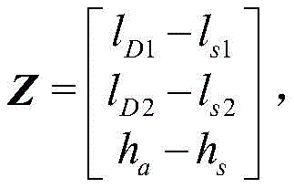
卡尔曼滤波器根据大气数据机输出的高度为ha和两个斜距值,构建出卡尔曼滤波器状态空间模型,计算出进入卡尔曼滤波器的量测值Z为:


根据SINS姿态误差方程、速度误差方程和位置误差方程建立如下式所示卡尔曼滤波的状态矩阵:According to the SINS attitude error equation, velocity error equation and position error equation, the state matrix of the Kalman filter is established as shown in the following formula:

式中:In the formula:


Map=M1+M2 M ap =M 1 +M 2
Mva=fn×M va =f n ×

Mvp=(vn×)(2M1+M2)M vp =(v n ×)(2M 1 +M 2 )


式中:


在可选的实施例中,选取地理坐标系为导航坐标系,得到如下式所示的系统噪声驱动阵G:In an optional embodiment, the geographic coordinate system is selected as the navigation coordinate system, and the system noise driving matrix G shown in the following formula is obtained:

经过一系列数学推导,可得到具有如下形式的量测矩阵H:After a series of mathematical derivations, the measurement matrix H with the following form can be obtained:

式中矩阵N=PM,其中:矩阵P和矩阵M按如下方式进行计算:In the formula, matrix N=PM, wherein: matrix P and matrix M are calculated as follows:


式中:xD1、yD1和zD1为地面DME台站1的位置;xD2、yD2和zD2为地面DME台站2的位置;e为椭圆偏心率。Where: x D1 , y D1 and z D1 are the positions of ground DME station 1; x D2 , y D2 and z D2 are the positions of ground DME station 2; e is the eccentricity of the ellipse.
在每个滤波时刻可得到15维状态变量的估计值,根据可观测性分析得到的结果,仅有姿态误差、速度误差和位置误差能得到准确估计,因而在滤波估计时刻仅利用估计得到的姿态误差、速度误差和位置误差反馈校正SINS的姿态、速度和位置,以此来抑制SINS随时间积累的导航误差。The estimated value of the 15-dimensional state variable can be obtained at each filtering moment. According to the results of the observability analysis, only the attitude error, velocity error and position error can be accurately estimated, so only the estimated attitude is used at the filtering estimation moment Error, velocity error and position error feedback correct the attitude, velocity and position of SINS to suppress the navigation error accumulated by SINS over time.
以上对本发明实施例进行了详细介绍,本文中应用了具体实施方式对本发明进行了阐述,以上实施例的说明只是用于帮助理解本发明的方法及设备;同时,对于本领域的一般技术人员,依据本发明的思想,在具体实施方式及应用范围上均会有改变之处,综上所述,本说明书内容不应理解为对本发明的限制。The embodiments of the present invention have been described in detail above, and the present invention has been described using specific implementation methods herein. The descriptions of the above embodiments are only used to help understand the method and equipment of the present invention; meanwhile, for those of ordinary skill in the art, According to the idea of the present invention, there will be changes in the specific implementation and scope of application. To sum up, the contents of this specification should not be construed as limiting the present invention.
Claims (10)


Priority Applications (1)
| Application Number | Priority Date | Filing Date | Title |
|---|---|---|---|
| CN202110877439.2A CN115683092B (en) | 2021-07-31 | 2021-07-31 | Repositioning method for DME/DME/SINS (symmetric multi-user navigation system/strapdown inertial navigation system) |
Applications Claiming Priority (1)
| Application Number | Priority Date | Filing Date | Title |
|---|---|---|---|
| CN202110877439.2A CN115683092B (en) | 2021-07-31 | 2021-07-31 | Repositioning method for DME/DME/SINS (symmetric multi-user navigation system/strapdown inertial navigation system) |
Publications (2)
| Publication Number | Publication Date |
|---|---|
| CN115683092A true CN115683092A (en) | 2023-02-03 |
| CN115683092B CN115683092B (en) | 2024-06-28 |
Family
ID=85059688
Family Applications (1)
| Application Number | Title | Priority Date | Filing Date |
|---|---|---|---|
| CN202110877439.2A Active CN115683092B (en) | 2021-07-31 | 2021-07-31 | Repositioning method for DME/DME/SINS (symmetric multi-user navigation system/strapdown inertial navigation system) |
Country Status (1)
| Country | Link |
|---|---|
| CN (1) | CN115683092B (en) |
Cited By (5)
| Publication number | Priority date | Publication date | Assignee | Title |
|---|---|---|---|---|
| CN118857300A (en) * | 2024-07-17 | 2024-10-29 | 哈尔滨工程大学 | Navigation information optimization method of ROV in high dam and large reservoir environment |
| CN119255192A (en) * | 2024-10-10 | 2025-01-03 | 中国人民解放军空军工程大学 | A multi-station positioning method and system based on time-sharing inquiry |
| CN119642816A (en) * | 2024-11-27 | 2025-03-18 | 中国民用航空飞行学院 | SINS/DME/DME combined navigation robust method based on chi-square test |
| CN119666018A (en) * | 2024-11-26 | 2025-03-21 | 中国民用航空飞行学院 | Performance evaluation method of SINS/DME/DME integrated navigation system |
| CN119860782A (en) * | 2025-03-25 | 2025-04-22 | 中国电子科技集团公司第十研究所 | Data link relative navigation information fusion method and device |
Citations (3)
| Publication number | Priority date | Publication date | Assignee | Title |
|---|---|---|---|---|
| CN108344415A (en) * | 2018-01-30 | 2018-07-31 | 北京大学 | A kind of integrated navigation information fusion method |
| AU2020103939A4 (en) * | 2020-12-08 | 2021-02-11 | Xi'an University Of Architecture And Technology | Polar Integrated Navigation Algorithm of SINS / GPS Based on Grid Framework |
| CN112525188A (en) * | 2020-12-15 | 2021-03-19 | 上海交通大学 | Combined navigation method based on federal filtering |
-
2021
- 2021-07-31 CN CN202110877439.2A patent/CN115683092B/en active Active
Patent Citations (3)
| Publication number | Priority date | Publication date | Assignee | Title |
|---|---|---|---|---|
| CN108344415A (en) * | 2018-01-30 | 2018-07-31 | 北京大学 | A kind of integrated navigation information fusion method |
| AU2020103939A4 (en) * | 2020-12-08 | 2021-02-11 | Xi'an University Of Architecture And Technology | Polar Integrated Navigation Algorithm of SINS / GPS Based on Grid Framework |
| CN112525188A (en) * | 2020-12-15 | 2021-03-19 | 上海交通大学 | Combined navigation method based on federal filtering |
Non-Patent Citations (2)
| Title |
|---|
| 周懿;汪小飞;田永锋;郑永梅;: "捷联惯导/北斗高精度组合导航方法研究", 计算机测量与控制, no. 04, 25 April 2016 (2016-04-25) * |
| 方涛: "考虑磁差的鲁棒DME/VOR/SINS组合导航算法", 电讯技术, vol. 62, no. 08, 15 July 2022 (2022-07-15) * |
Cited By (9)
| Publication number | Priority date | Publication date | Assignee | Title |
|---|---|---|---|---|
| CN118857300A (en) * | 2024-07-17 | 2024-10-29 | 哈尔滨工程大学 | Navigation information optimization method of ROV in high dam and large reservoir environment |
| CN119255192A (en) * | 2024-10-10 | 2025-01-03 | 中国人民解放军空军工程大学 | A multi-station positioning method and system based on time-sharing inquiry |
| CN119255192B (en) * | 2024-10-10 | 2025-10-03 | 中国人民解放军空军工程大学 | A multi-positioning method and system based on time-sharing query |
| CN119666018A (en) * | 2024-11-26 | 2025-03-21 | 中国民用航空飞行学院 | Performance evaluation method of SINS/DME/DME integrated navigation system |
| CN119666018B (en) * | 2024-11-26 | 2025-09-19 | 中国民用航空飞行学院 | Performance evaluation method of SINS/DME/DME integrated navigation system |
| CN119642816A (en) * | 2024-11-27 | 2025-03-18 | 中国民用航空飞行学院 | SINS/DME/DME combined navigation robust method based on chi-square test |
| CN119642816B (en) * | 2024-11-27 | 2025-09-19 | 中国民用航空飞行学院 | SINS/DME/DME combined navigation robust method based on chi-square test |
| CN119860782A (en) * | 2025-03-25 | 2025-04-22 | 中国电子科技集团公司第十研究所 | Data link relative navigation information fusion method and device |
| CN119860782B (en) * | 2025-03-25 | 2025-06-17 | 中国电子科技集团公司第十研究所 | Data link relative navigation information fusion method and device |
Also Published As
| Publication number | Publication date |
|---|---|
| CN115683092B (en) | 2024-06-28 |
Similar Documents
| Publication | Publication Date | Title |
|---|---|---|
| CN115683092A (en) | DME/DME/SINS tightly-combined navigation system relocation method | |
| CN102636149B (en) | Combined measurement device and method for dynamic deformation of flexible bodies | |
| CN101858748B (en) | Fault-tolerance autonomous navigation method of multi-sensor of high-altitude long-endurance unmanned plane | |
| CN103217157B (en) | A kind of inertial navigation/odometer independent combined navigation method | |
| CN110487301A (en) | A radar-assisted airborne strapdown inertial navigation system initial alignment method | |
| CN115096303B (en) | A GNSS multi-antenna and INS tightly combined positioning and attitude determination method and device | |
| Georgy et al. | Vehicle navigator using a mixture particle filter for inertial sensors/odometer/map data/GPS integration | |
| CN110057356B (en) | Method and device for locating vehicle in tunnel | |
| CN106767787A (en) | A kind of close coupling GNSS/INS combined navigation devices | |
| CN114459476B (en) | DVL/SINS integrated navigation method for underwater unmanned underwater vehicle flow measurement based on virtual speed measurement | |
| CN106405592B (en) | Vehicle-mounted Beidou carrier phase cycle slips detection and restorative procedure and system | |
| CN102508275A (en) | Multiple-antenna GPS(Global Positioning System)/GF-INS (Gyroscope-Free-Inertial Navigation System) depth combination attitude determining method | |
| CN108594272A (en) | A kind of anti-deceptive interference Combinated navigation method based on Robust Kalman Filter | |
| CN103149580A (en) | Global position system (GPS)/inertial navigation system (INS) combined navigation method based on strong tracking kalman filter (STKF) and wavelet neural network (WNN) | |
| CN103744096A (en) | Multi-information fusion positioning method and apparatus | |
| Zuo et al. | A GNSS/IMU/vision ultra-tightly integrated navigation system for low altitude aircraft | |
| Lyu et al. | Optimal time difference-based TDCP-GPS/IMU navigation using graph optimization | |
| CN113534227B (en) | Multi-sensor fusion absolute positioning method suitable for complex non-cooperative scene | |
| CN108594271A (en) | A kind of Combinated navigation method of the anti-deceptive interference based on composite layered filtering | |
| CN107015259A (en) | The tight integration method of pseudorange/pseudorange rates is calculated using Doppler anemometer | |
| CN114018242A (en) | An autonomous attitude determination method based on intelligent matching of polarization/sun/inertial information | |
| CN110207698B (en) | Polar region grid inertial navigation/ultra-short baseline tight combination navigation method | |
| CN103454664A (en) | GNSS carrier phase ambiguity solving method based on gyro measurement information constraint | |
| CN115356754A (en) | Combined navigation positioning method based on GNSS and low-orbit satellite | |
| Cahyadi et al. | Unscented Kalman filter for a low-cost GNSS/IMU-based mobile mapping application under demanding conditions |
Legal Events
| Date | Code | Title | Description |
|---|---|---|---|
| PB01 | Publication | ||
| PB01 | Publication | ||
| SE01 | Entry into force of request for substantive examination | ||
| SE01 | Entry into force of request for substantive examination | ||
| GR01 | Patent grant | ||
| GR01 | Patent grant |