CN116299542A - High-precision map construction method, device, storage medium and equipment - Google Patents
High-precision map construction method, device, storage medium and equipment Download PDFInfo
- Publication number
- CN116299542A CN116299542A CN202310179410.6A CN202310179410A CN116299542A CN 116299542 A CN116299542 A CN 116299542A CN 202310179410 A CN202310179410 A CN 202310179410A CN 116299542 A CN116299542 A CN 116299542A
- Authority
- CN
- China
- Prior art keywords
- point cloud
- frame
- distance
- point
- axis
- Prior art date
- Legal status (The legal status is an assumption and is not a legal conclusion. Google has not performed a legal analysis and makes no representation as to the accuracy of the status listed.)
- Pending
Links
Images


Classifications
-
- G—PHYSICS
- G01—MEASURING; TESTING
- G01S—RADIO DIRECTION-FINDING; RADIO NAVIGATION; DETERMINING DISTANCE OR VELOCITY BY USE OF RADIO WAVES; LOCATING OR PRESENCE-DETECTING BY USE OF THE REFLECTION OR RERADIATION OF RADIO WAVES; ANALOGOUS ARRANGEMENTS USING OTHER WAVES
- G01S17/00—Systems using the reflection or reradiation of electromagnetic waves other than radio waves, e.g. lidar systems
- G01S17/88—Lidar systems specially adapted for specific applications
- G01S17/89—Lidar systems specially adapted for specific applications for mapping or imaging
-
- G—PHYSICS
- G01—MEASURING; TESTING
- G01S—RADIO DIRECTION-FINDING; RADIO NAVIGATION; DETERMINING DISTANCE OR VELOCITY BY USE OF RADIO WAVES; LOCATING OR PRESENCE-DETECTING BY USE OF THE REFLECTION OR RERADIATION OF RADIO WAVES; ANALOGOUS ARRANGEMENTS USING OTHER WAVES
- G01S7/00—Details of systems according to groups G01S13/00, G01S15/00, G01S17/00
- G01S7/48—Details of systems according to groups G01S13/00, G01S15/00, G01S17/00 of systems according to group G01S17/00
- G01S7/4808—Evaluating distance, position or velocity data
-
- Y—GENERAL TAGGING OF NEW TECHNOLOGICAL DEVELOPMENTS; GENERAL TAGGING OF CROSS-SECTIONAL TECHNOLOGIES SPANNING OVER SEVERAL SECTIONS OF THE IPC; TECHNICAL SUBJECTS COVERED BY FORMER USPC CROSS-REFERENCE ART COLLECTIONS [XRACs] AND DIGESTS
- Y02—TECHNOLOGIES OR APPLICATIONS FOR MITIGATION OR ADAPTATION AGAINST CLIMATE CHANGE
- Y02A—TECHNOLOGIES FOR ADAPTATION TO CLIMATE CHANGE
- Y02A90/00—Technologies having an indirect contribution to adaptation to climate change
- Y02A90/10—Information and communication technologies [ICT] supporting adaptation to climate change, e.g. for weather forecasting or climate simulation
Landscapes
- Engineering & Computer Science (AREA)
- Physics & Mathematics (AREA)
- Computer Networks & Wireless Communication (AREA)
- General Physics & Mathematics (AREA)
- Radar, Positioning & Navigation (AREA)
- Remote Sensing (AREA)
- Electromagnetism (AREA)
- Optical Radar Systems And Details Thereof (AREA)
Abstract
Description
技术领域technical field
本申请涉及图像处理技术领域,特别涉及一种高精度地图的构建方法、装置、存储介质及设备。The present application relates to the technical field of image processing, and in particular to a method, device, storage medium and equipment for constructing a high-precision map.
背景技术Background technique
在依托高精度地图的自动驾驶方案中,高精度地图为定位、感知、PnC(Planningand Control,规划与控制)提供精确的先验环境信息,其具有高精度、多元素、高“新鲜”度等优势,是车辆进行安全决策和判断的重要前提,也是无人车能够安全、高效的完成各项任务的重要保障,因此,构建高精度地图是自动驾驶方案的重要基础和重要环节。In the automatic driving solution relying on high-precision maps, high-precision maps provide accurate prior environmental information for positioning, perception, and PnC (Planning and Control, planning and control), which have high precision, multiple elements, and high "freshness" Advantages are an important prerequisite for vehicles to make safe decisions and judgments, and are also an important guarantee for unmanned vehicles to complete various tasks safely and efficiently. Therefore, building high-precision maps is an important foundation and an important link for autonomous driving solutions.
高精度地图的构建方法一般有两种:一种是通过传统的测绘方法创建高精度地图,具体通过高精度的惯导设备对车辆的位姿进行采集,并将车载的激光雷达数据进行投影生成高精度地图。另外一种是通过SLAM(Simultaneous Localization and Mapping,同时定位与地图构建)技术创建高精度地图,具体是采用配准的方法估计车载的每帧激光雷达数据对应的位姿,通过回环检测和全局优化对误差进行消除,最终生成高精度地图。There are generally two methods for constructing high-precision maps: one is to create high-precision maps through traditional surveying and mapping methods, specifically to collect the pose of the vehicle through high-precision inertial navigation equipment, and project the vehicle-mounted lidar data to generate High-resolution maps. The other is to create a high-precision map through SLAM (Simultaneous Localization and Mapping, simultaneous positioning and map construction) technology. Specifically, the registration method is used to estimate the pose corresponding to each frame of lidar data on the vehicle, and the loop detection and global optimization Eliminate the error and finally generate a high-precision map.
传统的测绘方法虽然可以快速地测量车载的位姿,但是其易受到环境的干扰,特别是在楼宇之间和茂密的树下,其位姿的误差往往过大而无法满足高精度地图的需求。在无法通过高精度的惯导设备采集位姿的情况,我们可以采用SLAM技术对位姿进行精确的估计。其中,SLAM技术包括前端里程计。前端里程计可以采用ICP(Iterative Closest Point,迭代最近点)、GICP(Generalized Iterative Closest Point,广义迭代最近点)、NDT(Normal Distribution Transform,正态分布变换)等方法,但是其计算量比较大,且随着地图的范围增加,计算效率大大降低;因而,采用基于特征的方法逐渐成为了前端里程计的主流方法,例如LOAM(Lidar Odometry and Mapping,激光里程计与制图),但是其只提取了环境中的角点和面点作为特征进行位姿的估计,在z轴的约束比较少,累计误差会随着移动的距离越远而越大,导致在z轴上迅速发散。Although the traditional surveying and mapping method can quickly measure the pose of the vehicle, it is susceptible to environmental interference, especially between buildings and under dense trees. The error of the pose is often too large to meet the needs of high-precision maps. . In the case where the pose cannot be collected by high-precision inertial navigation equipment, we can use SLAM technology to accurately estimate the pose. Among them, SLAM technology includes front-end odometer. The front-end odometer can use ICP (Iterative Closest Point, iterative closest point), GICP (Generalized Iterative Closest Point, generalized iterative closest point), NDT (Normal Distribution Transform, normal distribution transformation) and other methods, but the calculation amount is relatively large, And as the scope of the map increases, the calculation efficiency is greatly reduced; therefore, the feature-based method has gradually become the mainstream method of the front-end odometer, such as LOAM (Lidar Odometry and Mapping, laser odometer and mapping), but it only extracts Corner points and surface points in the environment are used as features to estimate the pose. There are fewer constraints on the z-axis, and the cumulative error will increase with the distance moved, resulting in rapid divergence on the z-axis.
发明内容Contents of the invention
本申请提供了一种高精度地图的构建方法、装置、存储介质及设备,用于解决在高精度建图过程中,z轴发散过快的问题。所述技术方案如下:The present application provides a high-precision map construction method, device, storage medium and equipment, which are used to solve the problem of excessive z-axis divergence in the process of high-precision map construction. Described technical scheme is as follows:
一方面,提供了一种高精度地图的构建方法,所述方法包括:On the one hand, a method for constructing a high-precision map is provided, and the method includes:
获取当前帧和前一帧激光雷达数据的点云集合,所述点云集合包括地面点、角点和面点;Obtain the point cloud collection of the current frame and the previous frame lidar data, the point cloud collection includes ground points, corner points and surface points;
获取点云距离模型,根据所述点云距离模型计算所述当前帧与所述前一帧中同类点云之间的距离;Obtain a point cloud distance model, and calculate the distance between the current frame and the similar point cloud in the previous frame according to the point cloud distance model;
根据所述距离创建误差函数,根据所述误差函数计算所述当前帧相对于所述前一帧的位姿;creating an error function according to the distance, and calculating the pose of the current frame relative to the previous frame according to the error function;
根据所述位姿创建高精度地图。Create a high-resolution map from the pose.
在一种可能的实现方式中,所述获取点云距离模型,根据所述点云距离模型计算所述当前帧与所述前一帧中同类点云之间的距离,包括:In a possible implementation manner, the acquiring a point cloud distance model, and calculating the distance between the current frame and the same type of point cloud in the previous frame according to the point cloud distance model includes:
当所述点云距离模型为地面点距离模型时,计算所述当前帧的点云集合中的每个地面点到所述前一帧中地面的平面距离,所述地面由所述前一帧的点云集合中的地面点构成。When the point cloud distance model is a ground point distance model, calculate the plane distance from each ground point in the point cloud set of the current frame to the ground in the previous frame, and the ground is determined by the previous frame The ground points in the point cloud collection of .
在一种可能的实现方式中,所述获取点云距离模型,根据所述点云距离模型计算所述当前帧与所述前一帧中同类点云之间的距离,包括:In a possible implementation manner, the acquiring a point cloud distance model, and calculating the distance between the current frame and the same type of point cloud in the previous frame according to the point cloud distance model includes:
当所述点云距离模型为角点距离模型时,计算所述当前帧的点云集合中的每个角点到所述前一帧的角点的角线距离。When the point cloud distance model is a corner point distance model, calculate the angular line distance from each corner point in the point cloud set of the current frame to the corner point in the previous frame.
在一种可能的实现方式中,所述获取点云距离模型,根据所述点云距离模型计算所述当前帧与所述前一帧中同类点云之间的距离,包括:In a possible implementation manner, the acquiring a point cloud distance model, and calculating the distance between the current frame and the same type of point cloud in the previous frame according to the point cloud distance model includes:
当所述点云距离模型为面点距离模型时,计算所述当前帧的点云集合中的每个面点到所述前一帧中平面的平面距离,所述平面由所述前一帧的点云集合中的面点构成。When the point cloud distance model is a surface point distance model, calculate the plane distance from each surface point in the point cloud collection of the current frame to the plane in the previous frame, and the plane is determined by the previous frame The surface points in the point cloud collection of .
在一种可能的实现方式中,所述方法还包括:In a possible implementation, the method further includes:
对各帧激光雷达数据的点云集合进行回环检测;Perform loopback detection on the point cloud collection of each frame of lidar data;
若检测到第m个点云集合和第n个点云集合之间存在回环,则对所述第m个点云集合和所述第n个点云集合中的地面点进行匹配,得到第m帧和第n帧激光雷达数据之间的z轴、横滚角和俯仰角的变换值;If it is detected that there is a loop between the m-th point cloud set and the n-th point cloud set, then the m-th point cloud set is matched with the ground points in the n-th point cloud set to obtain the m-th point cloud set Transformation values of the z-axis, roll angle, and pitch angle between the frame and the nth frame of lidar data;
将z轴、横滚角和俯仰角的变换值作为初始值,计算第m帧和第n帧激光雷达数据之间的x轴、y轴和偏航角的变换值;Using the transformation values of z-axis, roll angle and pitch angle as initial values, calculate the transformation values of x-axis, y-axis and yaw angle between the mth frame and the nth frame of lidar data;
将x轴、y轴、z轴、偏航角、横滚角和俯仰角的变换值作为初始值,利用ICP算法计算第m帧和第n帧激光雷达数据之间的最终变换值。The transformation values of x-axis, y-axis, z-axis, yaw angle, roll angle and pitch angle are taken as initial values, and the final transformation value between the mth frame and the nth frame of lidar data is calculated using the ICP algorithm.
在一种可能的实现方式中,所述将z轴、横滚角和俯仰角的变换值作为初始值,计算第m帧和第n帧激光雷达数据之间的x轴、y轴和偏航角的变换值,包括:In a possible implementation, the transformation values of the z-axis, roll angle, and pitch angle are used as initial values to calculate the x-axis, y-axis, and yaw between the mth frame and the nth frame of lidar data Transformation values for angles, including:
将z轴、横滚角和俯仰角的变换值作为初始值,将所述第m个点云集合和所述第n个点云集合中的角点和面点压缩成二维地图;Using the transformation values of the z-axis, roll angle and pitch angle as initial values, compressing the corner points and surface points in the m point cloud collection and the n point cloud collection into a two-dimensional map;
利用CSM扫描匹配算法对所述二维地图进行匹配,得到所述第m帧和所述第n帧激光雷达数据之间的x轴、y轴和偏航角的变换值。The two-dimensional map is matched using a CSM scanning matching algorithm to obtain transformation values of the x-axis, y-axis and yaw angle between the mth frame and the nth frame of lidar data.
在一种可能的实现方式中,所述根据所述位姿创建高精度地图,包括:In a possible implementation, the creating a high-precision map according to the pose includes:
根据所述位姿和所述最终变换值创建所述高精度地图。The high-precision map is created based on the pose and the final transformation value.
一方面,提供了一种高精度地图的构建装置,所述装置包括:On the one hand, a device for constructing a high-precision map is provided, and the device includes:
获取模块,用于获取当前帧和前一帧激光雷达数据的点云集合,所述点云集合包括地面点、角点和面点;The obtaining module is used to obtain the point cloud collection of the current frame and the previous frame lidar data, and the point cloud collection includes ground points, corner points and surface points;
所述获取模块,还用于获取点云距离模型,根据所述点云距离模型计算所述当前帧与所述前一帧中同类点云之间的距离;The obtaining module is also used to obtain a point cloud distance model, and calculate the distance between the current frame and the similar point cloud in the previous frame according to the point cloud distance model;
计算模块,用于根据所述距离创建误差函数,根据所述误差函数计算所述当前帧相对于所述前一帧的位姿;A calculation module, configured to create an error function according to the distance, and calculate the pose of the current frame relative to the previous frame according to the error function;
创建模块,用于根据所述位姿创建高精度地图。Create a module for creating a high-resolution map from the pose.
一方面,提供了一种计算机可读存储介质,所述存储介质中存储有至少一条指令,所述至少一条指令由处理器加载并执行以实现如上所述的高精度地图的构建方法。In one aspect, a computer-readable storage medium is provided, wherein at least one instruction is stored in the storage medium, and the at least one instruction is loaded and executed by a processor to implement the method for constructing a high-precision map as described above.
一方面,提供了一种计算机设备,所述计算机设备包括处理器和存储器,所述存储器中存储有至少一条指令,所述指令由所述处理器加载并执行以实现如上所述的高精度地图的构建方法。In one aspect, a computer device is provided, the computer device includes a processor and a memory, at least one instruction is stored in the memory, and the instruction is loaded and executed by the processor to realize the high-precision map as described above The construction method.
本申请提供的技术方案的有益效果至少包括:The beneficial effects of the technical solution provided by the application at least include:
通过将点云集合中的点云划分为地面点、角点和面点这三个类别,再进行高精度地图的创建,这样,既可以增加特征的多样性,也可以通过对地面点的单独处理来增加z轴的约束,缓解z轴发散过快的问题。By dividing the point cloud in the point cloud collection into three categories: ground point, corner point and surface point, and then creating a high-precision map, this can not only increase the diversity of features, but also through the individual ground points Processing to increase the constraints of the z-axis to alleviate the problem of too fast divergence of the z-axis.
通过将地面点引入回环匹配的环节中,能够解耦6自由度位姿的估计,实现在较大累计误差下的匹配成功率和精度,并缩短了计算的时间。By introducing the ground point into the loop-back matching process, the estimation of the 6-DOF pose can be decoupled, the matching success rate and accuracy can be achieved under a large cumulative error, and the calculation time can be shortened.
附图说明Description of drawings
为了更清楚地说明本申请实施例中的技术方案,下面将对实施例描述中所需要使用的附图作简单地介绍,显而易见地,下面描述中的附图仅仅是本申请的一些实施例,对于本领域普通技术人员来讲,在不付出创造性劳动的前提下,还可以根据这些附图获得其他的附图。In order to more clearly illustrate the technical solutions in the embodiments of the present application, the drawings that need to be used in the description of the embodiments will be briefly introduced below. Obviously, the drawings in the following description are only some embodiments of the present application. For those skilled in the art, other drawings can also be obtained based on these drawings without creative effort.
图1是本申请一个实施例提供的高精度地图的构建方法的方法流程图;Fig. 1 is a method flowchart of a method for constructing a high-precision map provided by an embodiment of the present application;
图2是本申请一个实施例提供的高精度地图的构建方法的方法流程图;Fig. 2 is a method flowchart of a method for constructing a high-precision map provided by an embodiment of the present application;
图3是本申请再一实施例提供的高精度地图的构建装置的结构框图;Fig. 3 is a structural block diagram of a high-precision map construction device provided by another embodiment of the present application;
图4是本申请再一实施例提供的高精度地图的构建装置的结构框图。Fig. 4 is a structural block diagram of an apparatus for constructing a high-precision map provided by yet another embodiment of the present application.
具体实施方式Detailed ways
为使本申请实施例的目的、技术方案和优点更加清楚,下面将结合附图对本申请实施方式作进一步地详细描述。In order to make the purpose, technical solutions and advantages of the embodiments of the present application clearer, the following will further describe the embodiments of the present application in detail in conjunction with the accompanying drawings.
请参考图1,其示出了本申请一个实施例提供的高精度地图的构建方法的方法流程图,该高精度地图的构建方法可以应用于计算机设备中。该高精度地图的构建方法,可以包括:Please refer to FIG. 1 , which shows a flow chart of a method for constructing a high-precision map provided by an embodiment of the present application. The method for constructing a high-precision map can be applied to a computer device. The method for constructing the high-precision map may include:
步骤101,获取当前帧和前一帧激光雷达数据的点云集合,该点云集合包括地面点、角点和面点。In
自动驾驶的车辆中装载有激光雷达,激光雷达能够周期性对周围环境进行采集,得到激光雷达数据,根据每帧激光雷达数据生成一个点云集合。The self-driving vehicle is equipped with lidar, which can periodically collect the surrounding environment, obtain lidar data, and generate a point cloud set based on each frame of lidar data.
计算机设备在获取到点云集合后,对点云进行预处理,将点云划分为地面点(ground)和非地面点(non-ground)。其中,从点云中提取地面点的方法有很多种,本实施例中不作限定。对于非地面点,计算机设备可以根据曲率将非地面点划分为角点和面点。因此,一个点云集合中包括地面点、角点和面点。After the computer device obtains the point cloud set, it preprocesses the point cloud, and divides the point cloud into ground points (ground) and non-ground points (non-ground). There are many methods for extracting ground points from the point cloud, which are not limited in this embodiment. For non-ground points, the computer device can divide the non-ground points into corner points and surface points according to the curvature. Therefore, a point cloud set includes ground points, corner points and surface points.
步骤102,获取点云距离模型,根据点云距离模型计算当前帧与前一帧中同类点云之间的距离。
计算机设备可以根据每个类别的点云的特征进行建模,得到点云距离模型,并利用点云距离模型计算当前帧与前一帧中同类点云之间的距离。本实施例中,将针对地面点创建的点云距离模型称为地面点距离模型,将针对角点创建的点云距离模型称为角点距离模型,将针对面点创建的点云距离模型称为面点距离模型。下面分别对三种点云距离模型的计算方式进行说明。The computer device can perform modeling according to the characteristics of each category of point clouds to obtain a point cloud distance model, and use the point cloud distance model to calculate the distance between the current frame and the same type of point cloud in the previous frame. In this embodiment, the point cloud distance model created for ground points is called ground point distance model, the point cloud distance model created for corner points is called corner point distance model, and the point cloud distance model created for surface points is called is the surface point distance model. The calculation methods of the three point cloud distance models are described below.
(1)点云距离模型为地面点距离模型;(1) The point cloud distance model is the ground point distance model;
具体的,获取点云距离模型,根据点云距离模型计算当前帧与前一帧中同类点云之间的距离,可以包括:当点云距离模型为地面点距离模型时,计算当前帧的点云集合中的每个地面点到前一帧中地面的平面距离,该地面由前一帧的点云集合中的地面点构成。其中,地面点距离模型用于估计当前地面点到目标点云集合中的地面点构成的平面距离。Specifically, obtain the point cloud distance model, and calculate the distance between the current frame and the same point cloud in the previous frame according to the point cloud distance model, which may include: when the point cloud distance model is a ground point distance model, calculate the point of the current frame The planar distance from each ground point in the cloud set to the ground in the previous frame, which is formed by the ground points in the point cloud set in the previous frame. Among them, the ground point distance model is used to estimate the plane distance between the current ground point and the ground points in the target point cloud set.
假设当前帧为第k+1帧,其对应的点云集合为Xk+1,前一帧为第k帧,其对应的点云集合为Xk,对于地面点i,其中i∈Xk+1,通过最近邻搜索出Xk中相近的三个地面点j、l和p,且这三个地面点j、l和p可以构成一个地面,因此,当前地面点i到该地面的平面距离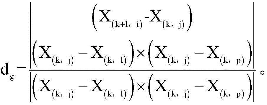
(2)点云距离模型为角点距离模型;(2) The point cloud distance model is a corner point distance model;
具体的,获取点云距离模型,根据点云距离模型计算当前帧与前一帧中同类点云之间的距离,可以包括:当点云距离模型为角点距离模型时,计算当前帧的点云集合中的每个角点到前一帧的角点的角线距离。其中,角点距离模型用于估计当前角点到目标点云的角线距离。Specifically, obtain the point cloud distance model, and calculate the distance between the current frame and the same point cloud in the previous frame according to the point cloud distance model, which may include: when the point cloud distance model is a corner point distance model, calculate the point of the current frame The angular distance from each corner point in the cloud collection to the corner point in the previous frame. Among them, the corner distance model is used to estimate the corner distance from the current corner to the target point cloud.
假设当前帧为第k+1帧,其对应的点云集合为Xk+1,前一帧为第k帧,其对应的点云集合为Xk,对于角点i,其中i∈Xk+1,通过最近邻搜索出Xk中相近的两个角点j和l,且这两个角点j和l可以构成一条直线,因此,当前角点i到连线的角线距离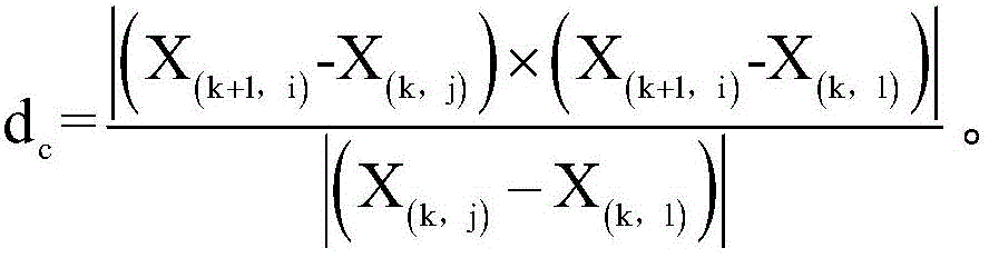
(3)点云距离模型为面点距离模型;(3) The point cloud distance model is a surface point distance model;
具体的,获取点云距离模型,根据点云距离模型计算当前帧与前一帧中同类点云之间的距离,可以包括:当点云距离模型为面点距离模型时,计算当前帧的点云集合中的每个面点到前一帧中平面的平面距离,平面由前一帧的点云集合中的面点构成。其中,面点距离模型用于估计当前面点到目标点云集合中的面点构成的平面距离。Specifically, obtain the point cloud distance model, and calculate the distance between the current frame and the same point cloud in the previous frame according to the point cloud distance model, which may include: when the point cloud distance model is a surface point distance model, calculate the point of the current frame The plane distance from each surface point in the cloud collection to the plane in the previous frame, and the plane is composed of the surface points in the point cloud collection in the previous frame. Among them, the surface point distance model is used to estimate the plane distance between the current surface point and the surface points in the target point cloud set.
假设当前帧为第k+1帧,其对应的点云集合为Xk+1,前一帧为第k帧,其对应的点云集合为Xk,对于面点i,其中i∈Xk+1,通过最近邻搜索出Xk中相近的三个面点j、l和p,且这三个面点j、l和p可以构成一个平面,因此,当前面点i到该平面的平面距离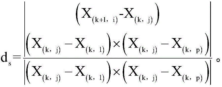
步骤103,根据距离创建误差函数,根据误差函数计算当前帧相对于前一帧的位姿。
计算当前帧与前一帧中同类点云之间的距离也可以称为运动估计,其目的是计算变换的位姿。Calculating the distance between the current frame and the same point cloud in the previous frame can also be called motion estimation, the purpose of which is to calculate the transformed pose.
计算机设备对不同特征的点云构建变换关系f(*),使得:The computer equipment constructs the transformation relationship f(*) for the point cloud of different features, so that:
fc(X(k+1,i),Tk+1)=dc,i∈εk+1 f c (X (k+1, i) , T k+1 )=d c , i∈ε k+1

fg(X(k+1,i),Tk+1)=dg,i∈δk+1 f g (X (k+1, i) , T k+1 )=d g , i∈δ k+1
其中,εk+1表示当前帧的点云集合中的角点集合,
计算机设备可以构建出误差函数f(Tk+1)=d,通过LM(列文伯格-马夸尔特)方法最小化d到0,以求解到最优的位姿变换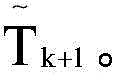
步骤104,根据位姿创建高精度地图。
在得到位姿后,计算机设备可以通过回环检测和全局优化对误差进行消除,最终生成高精度地图。After obtaining the pose, the computer equipment can eliminate errors through loop closure detection and global optimization, and finally generate a high-precision map.
综上所述,本申请实施例提供的高精度地图的构建方法,通过将点云集合中的点云划分为地面点、角点和面点这三个类别,再进行高精度地图的创建,这样,既可以增加特征的多样性,也可以通过对地面点的单独处理来增加z轴的约束,缓解z轴发散过快的问题。In summary, the high-precision map construction method provided by the embodiment of the present application divides the point cloud in the point cloud collection into three categories: ground points, corner points, and surface points, and then creates a high-precision map. In this way, the diversity of features can be increased, and the constraint of the z-axis can be increased by separately processing the ground points, so as to alleviate the problem of too fast divergence of the z-axis.
SLAM技术除了包括前端里程计,还包括后端优化。后端优化往往通过添加回环来消除累计的误差,回环往往采用了ICP等匹配方法,然而,若两帧激光雷达数据之间的累计误差过大,其很难计算出正确的回环位姿。为此,我们也可以采用全局的匹配方法进行位姿的估计,例如Cartographer,其采用CSM(Correlation Scan Match,相关扫描匹配)进行位姿估计,但是在6自由度的估计上其耗时会大大增加,降低了建图的整体计算效率。为了解决回环匹配资源消耗过大的问题,本实施例提供了一种回环检测方法,具体流程请参考图2:In addition to front-end odometer, SLAM technology also includes back-end optimization. Back-end optimization often eliminates accumulated errors by adding loopbacks. Matching methods such as ICP are often used for loopbacks. However, if the cumulative error between two frames of lidar data is too large, it is difficult to calculate the correct loopback pose. For this reason, we can also use a global matching method to estimate the pose, such as Cartographer, which uses CSM (Correlation Scan Match, Correlation Scan Match) for pose estimation, but it takes a lot of time to estimate the 6 degrees of freedom increases, reducing the overall computational efficiency of mapping. In order to solve the problem of excessive consumption of loopback matching resources, this embodiment provides a loopback detection method, please refer to Figure 2 for the specific process:
步骤201,对各帧激光雷达数据的点云集合进行回环检测。
计算机设备可以通过很多方法对点云集合进行回环检测,本实施例中不作限定。The computer device can perform loopback detection on the point cloud set through many methods, which are not limited in this embodiment.
若检测到存在回环,则计算机设备会得到两帧激光雷达数据的点云集合,下面需要计算这两个点云集合之间的变换。If a loop is detected, the computer device will obtain a point cloud set of two frames of lidar data, and the transformation between the two point cloud sets needs to be calculated below.
步骤202,若检测到第m个点云集合和第n个点云集合之间存在回环,则对第m个点云集合和第n个点云集合中的地面点进行匹配,得到第m帧和第n帧激光雷达数据之间的z轴、横滚角和俯仰角的变换值。
假设检测到的两帧激光雷达数据为第m帧和第n帧激光雷达数据,则对应的是第m个和第n个点云集合。计算机设备可以将一个点云集合固定为目标点云集合,计算另外一个点云集合相对于目标点云集合的变换。其中,计算过程分为两个部分,第一部分是对第m个和第n个点云集合中的地面点进行匹配,第二部分是对第m个和第n个点云集合中的角点和面点进行匹配。Assuming that the detected two frames of lidar data are the m-th frame and the n-th frame of lidar data, the corresponding points are the m-th and n-th point cloud sets. The computer device can fix one point cloud set as the target point cloud set, and calculate the transformation of another point cloud set relative to the target point cloud set. Among them, the calculation process is divided into two parts, the first part is to match the ground points in the mth and nth point cloud sets, and the second part is to match the corner points in the mth and nth point cloud sets Match with pasta.
在求解第一部分时,计算机设备利用Normal-Icp的方法来处理地面点,优先估计[z,roll,pitch]这三个自由度的变换值。其中,z表示z轴、roll表示横滚角,pitch表示俯仰角。When solving the first part, the computer equipment uses the Normal-Icp method to process the ground points, and preferentially estimates the transformation values of the three degrees of freedom [z, roll, pitch]. Among them, z represents the z-axis, roll represents the roll angle, and pitch represents the pitch angle.
步骤203,将z轴、横滚角和俯仰角的变换值作为初始值,计算第m帧和第n帧激光雷达数据之间的x轴、y轴和偏航角的变换值。
具体的,计算机设备可以将z轴、横滚角和俯仰角的变换值作为初始值,将第m个点云集合和第n个点云集合中的角点和面点压缩成二维地图;利用CSM扫描匹配算法对二维地图进行匹配,得到第m帧和第n帧激光雷达数据之间的x轴、y轴和偏航角的变换值。Specifically, the computer device can use the transformation values of the z-axis, roll angle, and pitch angle as initial values, and compress the corner points and surface points in the m-th point cloud set and the n-th point cloud set into a two-dimensional map; The CSM scan matching algorithm is used to match the two-dimensional map, and the transformation values of the x-axis, y-axis and yaw angle between the m-th frame and the n-th frame of lidar data are obtained.
其中,计算机设备可以将z轴、横滚角和俯仰角的变换值作为初始值进行固定,进一步处理角点和面点。在将角点和面点压缩成二维地图后,计算机设备可以采用CSM的方法进行匹配以计算[x,y,yaw]这三个自由度的变换值。其中,x表示x轴、y表示y轴,yaw表示偏航角。Wherein, the computer device can fix the transformation values of the z-axis, roll angle and pitch angle as initial values, and further process the corner points and surface points. After compressing the corner points and surface points into a two-dimensional map, the computer device can use the CSM method to perform matching to calculate the transformation values of the three degrees of freedom [x, y, yaw]. Among them, x represents the x-axis, y represents the y-axis, and yaw represents the yaw angle.
步骤204,将x轴、y轴、z轴、偏航角、横滚角和俯仰角的变换值作为初始值,利用ICP算法计算第m帧和第n帧激光雷达数据之间的最终变换值。
计算机设备将两次计算得到的变换值进行组合,最终得到[x,y,z,roll,pitch,yaw]这6个自由度的变换值。由于计算过程中会存在离散化的误差,所以,计算机设备还需要将6自由度的变换值作为初值,再对第m帧和第n帧激光雷达数据做一个ICP匹配,就可以求得最终的精确的两帧激光雷达数据的变换。这种回环的匹配方法一方面可以提高在较大累计误差下的匹配成功率和精度;另一方面也大大的缩短了计算的时间,提高了效率。The computer equipment combines the transformation values obtained from the two calculations to finally obtain the transformation values of the 6 degrees of freedom [x, y, z, roll, pitch, yaw]. Since there will be discretization errors in the calculation process, the computer equipment also needs to use the transformation value of 6 degrees of freedom as the initial value, and then perform an ICP match on the mth and nth frames of lidar data to obtain the final The exact two-frame transformation of lidar data. On the one hand, this loopback matching method can improve the matching success rate and accuracy under a large cumulative error; on the other hand, it also greatly shortens the calculation time and improves the efficiency.
若引入了回环匹配,则步骤104可以替换为:根据位姿和最终变换值创建高精度地图。If loop-closing matching is introduced,
本实施例中,通过将地面点引入回环匹配的环节中,能够解耦6自由度位姿的估计,实现在较大累计误差下的匹配成功率和精度,并缩短了计算的时间。In this embodiment, by introducing the ground point into the loop-back matching link, the estimation of the 6-DOF pose can be decoupled, the matching success rate and accuracy can be achieved under a large cumulative error, and the calculation time can be shortened.
请参考图3,其示出了本申请一个实施例提供的高精度地图的构建装置的结构框图,该高精度地图的构建装置可以应用于计算机设备中。该高精度地图的构建装置,可以包括:Please refer to FIG. 3 , which shows a structural block diagram of an apparatus for constructing a high-precision map provided by an embodiment of the present application. The apparatus for constructing a high-precision map can be applied to a computer device. The device for constructing the high-precision map may include:
获取模块310,用于获取当前帧和前一帧激光雷达数据的点云集合,点云集合包括地面点、角点和面点;Obtaining
获取模块310,还用于获取点云距离模型,根据点云距离模型计算当前帧与前一帧中同类点云之间的距离;The obtaining
计算模块320,用于根据距离创建误差函数,根据误差函数计算当前帧相对于前一帧的位姿;
创建模块330,用于根据位姿创建高精度地图。The
在一个可选的实施例中,计算模块320,还用于:In an optional embodiment, the calculating
当点云距离模型为地面点距离模型时,计算当前帧的点云集合中的每个地面点到前一帧中地面的平面距离,地面由前一帧的点云集合中的地面点构成。When the point cloud distance model is the ground point distance model, calculate the plane distance from each ground point in the point cloud set of the current frame to the ground in the previous frame, and the ground is composed of the ground points in the point cloud set of the previous frame.
在一个可选的实施例中,计算模块320,还用于:In an optional embodiment, the calculating
当点云距离模型为角点距离模型时,计算当前帧的点云集合中的每个角点到前一帧的角点的角线距离。When the point cloud distance model is a corner point distance model, calculate the angular line distance from each corner point in the point cloud collection of the current frame to the corner point of the previous frame.
在一个可选的实施例中,计算模块320,还用于:In an optional embodiment, the calculating
当点云距离模型为面点距离模型时,计算当前帧的点云集合中的每个面点到前一帧中平面的平面距离,平面由前一帧的点云集合中的面点构成。When the point cloud distance model is the surface point distance model, calculate the plane distance from each surface point in the point cloud collection of the current frame to the plane in the previous frame, and the plane is formed by the surface points in the point cloud collection of the previous frame.
请参考图4,在一个可选的实施例中,该装置还包括:Please refer to Figure 4, in an optional embodiment, the device also includes:
检测模块340,用于对各帧激光雷达数据的点云集合进行回环检测;The
匹配模块350,用于若检测到第m个点云集合和第n个点云集合之间存在回环,则对第m个点云集合和第n个点云集合中的地面点进行匹配,得到第m帧和第n帧激光雷达数据之间的z轴、横滚角和俯仰角的变换值;The
计算模块320,还用于将z轴、横滚角和俯仰角的变换值作为初始值,计算第m帧和第n帧激光雷达数据之间的x轴、y轴和偏航角的变换值;The
计算模块320,还用于将x轴、y轴、z轴、偏航角、横滚角和俯仰角的变换值作为初始值,利用ICP算法计算第m帧和第n帧激光雷达数据之间的最终变换值。The
在一个可选的实施例中,计算模块320,还用于:In an optional embodiment, the calculating
将z轴、横滚角和俯仰角的变换值作为初始值,将第m个点云集合和第n个点云集合中的角点和面点压缩成二维地图;Using the transformation values of the z-axis, roll angle, and pitch angle as initial values, compress the corner points and surface points in the m-th point cloud collection and the n-th point cloud collection into a two-dimensional map;
利用CSM扫描匹配算法对二维地图进行匹配,得到第m帧和第n帧激光雷达数据之间的x轴、y轴和偏航角的变换值。The CSM scan matching algorithm is used to match the two-dimensional map, and the transformation values of the x-axis, y-axis and yaw angle between the m-th frame and the n-th frame of lidar data are obtained.
在一个可选的实施例中,创建模块330,还用于:In an optional embodiment, the
根据位姿和最终变换值创建高精度地图。Create a high-resolution map from the pose and final transformation values.
综上所述,本申请实施例提供的高精度地图的构建装置,通过将点云集合中的点云划分为地面点、角点和面点这三个类别,再进行高精度地图的创建,这样,既可以增加特征的多样性,也可以通过对地面点的单独处理来增加z轴的约束,缓解z轴发散过快的问题。In summary, the high-precision map construction device provided by the embodiment of the present application divides the point cloud in the point cloud collection into three categories: ground points, corner points, and surface points, and then creates a high-precision map. In this way, the diversity of features can be increased, and the constraint of the z-axis can be increased by separately processing the ground points, so as to alleviate the problem of too fast divergence of the z-axis.
通过将地面点引入回环匹配的环节中,能够解耦6自由度位姿的估计,实现在较大累计误差下的匹配成功率和精度,并缩短了计算的时间。By introducing the ground point into the loop-back matching process, the estimation of the 6-DOF pose can be decoupled, the matching success rate and accuracy can be achieved under a large cumulative error, and the calculation time can be shortened.
本申请一个实施例提供了一种计算机可读存储介质,所述存储介质中存储有至少一条指令,所述至少一条指令由处理器加载并执行以实现如上所述的高精度地图的构建方法。An embodiment of the present application provides a computer-readable storage medium, at least one instruction is stored in the storage medium, and the at least one instruction is loaded and executed by a processor to implement the above-mentioned method for constructing a high-precision map.
本申请一个实施例提供了一种计算机设备,所述计算机设备包括处理器和存储器,所述存储器中存储有至少一条指令,所述指令由所述处理器加载并执行以实现如上所述的高精度地图的构建方法。An embodiment of the present application provides a computer device, the computer device includes a processor and a memory, at least one instruction is stored in the memory, and the instruction is loaded and executed by the processor to realize the above-mentioned high-level The construction method of the precision map.
需要说明的是:上述实施例提供的高精度地图的构建装置在进行高精度地图的构建时,仅以上述各功能模块的划分进行举例说明,实际应用中,可以根据需要而将上述功能分配由不同的功能模块完成,即将高精度地图的构建装置的内部结构划分成不同的功能模块,以完成以上描述的全部或者部分功能。另外,上述实施例提供的高精度地图的构建装置与高精度地图的构建方法实施例属于同一构思,其具体实现过程详见方法实施例,这里不再赘述。It should be noted that: when the device for constructing a high-precision map provided by the above-mentioned embodiment constructs a high-precision map, the division of the above-mentioned functional modules is used as an example for illustration. In practical applications, the above-mentioned functions can be allocated by Different functional modules are completed, that is, the internal structure of the high-precision map construction device is divided into different functional modules to complete all or part of the functions described above. In addition, the high-precision map construction device and the high-precision map construction method embodiment provided by the above-mentioned embodiments belong to the same concept, and its specific implementation process is detailed in the method embodiment, and will not be repeated here.
本领域普通技术人员可以理解实现上述实施例的全部或部分步骤可以通过硬件来完成,也可以通过程序来指令相关的硬件完成,所述的程序可以存储于一种计算机可读存储介质中,上述提到的存储介质可以是只读存储器,磁盘或光盘等。Those of ordinary skill in the art can understand that all or part of the steps for implementing the above embodiments can be completed by hardware, and can also be completed by instructing related hardware through a program. The program can be stored in a computer-readable storage medium. The above-mentioned The storage medium mentioned may be a read-only memory, a magnetic disk or an optical disk, and the like.
以上所述并不用以限制本申请实施例,凡在本申请实施例的精神和原则之内,所作的任何修改、等同替换、改进等,均应包含在本申请实施例的保护范围之内。The above description is not intended to limit the embodiments of the present application, and any modifications, equivalent replacements, improvements, etc. made within the spirit and principles of the embodiments of the present application shall be included within the scope of protection of the embodiments of the present application.
Claims (10)
Priority Applications (1)
| Application Number | Priority Date | Filing Date | Title |
|---|---|---|---|
| CN202310179410.6A CN116299542A (en) | 2023-02-28 | 2023-02-28 | High-precision map construction method, device, storage medium and equipment |
Applications Claiming Priority (1)
| Application Number | Priority Date | Filing Date | Title |
|---|---|---|---|
| CN202310179410.6A CN116299542A (en) | 2023-02-28 | 2023-02-28 | High-precision map construction method, device, storage medium and equipment |
Publications (1)
| Publication Number | Publication Date |
|---|---|
| CN116299542A true CN116299542A (en) | 2023-06-23 |
Family
ID=86833511
Family Applications (1)
| Application Number | Title | Priority Date | Filing Date |
|---|---|---|---|
| CN202310179410.6A Pending CN116299542A (en) | 2023-02-28 | 2023-02-28 | High-precision map construction method, device, storage medium and equipment |
Country Status (1)
| Country | Link |
|---|---|
| CN (1) | CN116299542A (en) |
Citations (7)
| Publication number | Priority date | Publication date | Assignee | Title |
|---|---|---|---|---|
| CN109507677A (en) * | 2018-11-05 | 2019-03-22 | 浙江工业大学 | A kind of SLAM method of combination GPS and radar odometer |
| CN111275763A (en) * | 2020-01-20 | 2020-06-12 | 深圳市普渡科技有限公司 | Closed-loop detection system, multi-sensor fusion SLAM system and robot |
| CN111612829A (en) * | 2020-06-03 | 2020-09-01 | 纵目科技(上海)股份有限公司 | Method, system, terminal and storage medium for constructing high-precision map |
| CN112907610A (en) * | 2021-03-25 | 2021-06-04 | 东南大学 | LeGO-LOAM-based step-by-step interframe pose estimation algorithm |
| CN113487631A (en) * | 2021-07-21 | 2021-10-08 | 智能移动机器人(中山)研究院 | Adjustable large-angle detection sensing and control method based on LEGO-LOAM |
| CN113781582A (en) * | 2021-09-18 | 2021-12-10 | 四川大学 | Synchronous positioning and map creating method based on laser radar and inertial navigation combined calibration |
| CN115079202A (en) * | 2022-06-16 | 2022-09-20 | 智道网联科技(北京)有限公司 | Lidar mapping method, device and electronic device, storage medium |
-
2023
- 2023-02-28 CN CN202310179410.6A patent/CN116299542A/en active Pending
Patent Citations (7)
| Publication number | Priority date | Publication date | Assignee | Title |
|---|---|---|---|---|
| CN109507677A (en) * | 2018-11-05 | 2019-03-22 | 浙江工业大学 | A kind of SLAM method of combination GPS and radar odometer |
| CN111275763A (en) * | 2020-01-20 | 2020-06-12 | 深圳市普渡科技有限公司 | Closed-loop detection system, multi-sensor fusion SLAM system and robot |
| CN111612829A (en) * | 2020-06-03 | 2020-09-01 | 纵目科技(上海)股份有限公司 | Method, system, terminal and storage medium for constructing high-precision map |
| CN112907610A (en) * | 2021-03-25 | 2021-06-04 | 东南大学 | LeGO-LOAM-based step-by-step interframe pose estimation algorithm |
| CN113487631A (en) * | 2021-07-21 | 2021-10-08 | 智能移动机器人(中山)研究院 | Adjustable large-angle detection sensing and control method based on LEGO-LOAM |
| CN113781582A (en) * | 2021-09-18 | 2021-12-10 | 四川大学 | Synchronous positioning and map creating method based on laser radar and inertial navigation combined calibration |
| CN115079202A (en) * | 2022-06-16 | 2022-09-20 | 智道网联科技(北京)有限公司 | Lidar mapping method, device and electronic device, storage medium |
Similar Documents
| Publication | Publication Date | Title |
|---|---|---|
| CN114526745B (en) | Drawing construction method and system for tightly coupled laser radar and inertial odometer | |
| CN109709801B (en) | An indoor drone positioning system and method based on lidar | |
| CN114964212B (en) | Multi-machine collaborative fusion positioning and mapping method oriented to unknown space exploration | |
| CN110930495A (en) | Multi-unmanned aerial vehicle cooperation-based ICP point cloud map fusion method, system, device and storage medium | |
| CN108759833A (en) | A kind of intelligent vehicle localization method based on priori map | |
| CN117169942B (en) | Unmanned vehicle repositioning method based on LiDAR/GPS/IMU fusion | |
| CN113110455A (en) | Multi-robot collaborative exploration method, device and system for unknown initial state | |
| CN119022955B (en) | Plane combination strategy-based laser inertial odometer method and computer device | |
| Zhao et al. | Review of slam techniques for autonomous underwater vehicles | |
| CN114001733A (en) | Map-based consistency efficient visual inertial positioning algorithm | |
| CN114815899B (en) | Three-dimensional space path planning method for UAV based on 3D lidar sensor | |
| CN116429116A (en) | Method and device for positioning a robot | |
| CN118310531A (en) | Cross-scene positioning method and system for robot with coarse-to-fine point cloud registration | |
| CN114419118B (en) | Three-dimensional point cloud registration method, mobile device and storage medium | |
| CN120800360A (en) | Tightly coupled laser inertial vision fusion method based on merging probability voxel map | |
| CN112747752A (en) | Vehicle positioning method, device, equipment and storage medium based on laser odometer | |
| CN118549939A (en) | Method for global positioning of vehicle based on laser radar | |
| CN116299542A (en) | High-precision map construction method, device, storage medium and equipment | |
| CN119002538A (en) | Laser radar line-imitating flight method and device based on ICP | |
| CN118424256A (en) | A distributed multi-resolution map fusion mapping and positioning method and device | |
| CN115239899B (en) | Pose map generation method, high-precision map generation method and device | |
| CN117570979A (en) | A SLAM and path planning method based on multi-sensor fusion | |
| Chen et al. | A 3D LiDAR SLAM algorithm based on graph optimization in indoor scene | |
| CN114663605A (en) | Instant positioning map construction method, unmanned mobile equipment and computer program product | |
| CN119228996B (en) | A LiDAR point, line, and surface feature uncertainty adaptive modeling method and device |
Legal Events
| Date | Code | Title | Description |
|---|---|---|---|
| PB01 | Publication | ||
| PB01 | Publication | ||
| SE01 | Entry into force of request for substantive examination | ||
| SE01 | Entry into force of request for substantive examination |