CN1780285A - Hierarchical topological network geographic information displaying method - Google Patents
Hierarchical topological network geographic information displaying method Download PDFInfo
- Publication number
- CN1780285A CN1780285A CN 200410065401 CN200410065401A CN1780285A CN 1780285 A CN1780285 A CN 1780285A CN 200410065401 CN200410065401 CN 200410065401 CN 200410065401 A CN200410065401 A CN 200410065401A CN 1780285 A CN1780285 A CN 1780285A
- Authority
- CN
- China
- Prior art keywords
- latitude
- longitude
- delta
- topological
- map
- Prior art date
- Legal status (The legal status is an assumption and is not a legal conclusion. Google has not performed a legal analysis and makes no representation as to the accuracy of the status listed.)
- Pending
Links
Images


Landscapes
- Information Retrieval, Db Structures And Fs Structures Therefor (AREA)
Abstract
一种层次化拓扑网络地理信息展示方法,根据拓扑对象在物理空间的分布状况,构造拓扑网络的层次结构;对于层次结构中的每一个拓扑层,包括一个背景地图层和拓扑信息的节点、链路的拓扑对象层;构造一个经纬度坐标系,使各拓扑层都采用这个经纬度坐标系;构造各个拓扑层的自身的笛卡尔坐标系和背景地图的范围;构造每个拓扑层中包含的各个节点的坐标点;最后在计算机上展示各个拓扑层。本发明不仅给出了在一个拓扑层内的坐标表示,还给出了节点从一个拓扑层移动到另外一个拓扑层时,保持其位置不变的计算方法。

A method for displaying hierarchical topological network geographic information, constructing a hierarchical structure of a topological network according to the distribution of topological objects in physical space; for each topological layer in the hierarchical structure, including a background map layer and nodes and links of topological information The topological object layer of the road; construct a longitude-latitude coordinate system, so that each topological layer adopts this longitude-latitude coordinate system; construct each topological layer's own Cartesian coordinate system and the scope of the background map; construct each node contained in each topological layer Coordinate points; Finally, each topological layer is displayed on the computer. The invention not only provides the coordinate representation in a topological layer, but also provides a calculation method for keeping the position of the node when it moves from one topological layer to another topological layer.
Description
技术领域:Technical field:
本发明属于网络管理技术同地理信息技术结合的技术领域,特别是涉及了一种拓扑网络地理信息展示方法,尤其是在层次化的拓扑网络结构下地理信息的展示方法。The invention belongs to the technical field of combining network management technology with geographic information technology, and in particular relates to a method for displaying topological network geographic information, especially a method for displaying geographic information under a hierarchical topological network structure.
背景技术:Background technique:
电信网络管理技术是复杂的分布式系统,ITU-T提出了网络管理系统化的解决方案,包括故障管理、安全管理、性能管理、配置管理等功能。网络拓扑管理是网管系统的重要组成部分,它提供了一个虚拟的拓扑空间,直观地展现了所管理的网络和设备物理的或逻辑的层次关系,并对网络资源的运行状况的监控提供了方便的手段。但是传统的网络拓扑的实现并不完善,特别是对地理位置信息的支持能力非常有限,例如仅仅给用户呈现无价值的屏幕坐标信息,或者并没有将地理信息纳入到管理系统中。这越来越不适应于用户提出的需求。将网络拓扑管理同地理信息技术结合,需要提供新的表示方法,并解决层次结构下层与层之间的地理信息的转换关系。Telecommunications network management technology is a complex distributed system. ITU-T has proposed a systematic solution for network management, including functions such as fault management, security management, performance management, and configuration management. Network topology management is an important part of the network management system. It provides a virtual topology space, visually shows the physical or logical hierarchical relationship between the managed network and equipment, and provides convenience for monitoring the operating status of network resources. s method. However, the implementation of the traditional network topology is not perfect, especially the ability to support geographic location information is very limited, for example, only presenting worthless screen coordinate information to users, or not incorporating geographic information into the management system. This is more and more incompatible with the demands put forward by users. Combining network topology management with geographic information technology needs to provide a new representation method and solve the conversion relationship of geographic information between the lower layers of the hierarchy.
发明内容:Invention content:
本发明的目的是为了在网络、拓扑管理中提供一种地理信息的展示方法,提供一种比较精确的方法,方便地表示和计算网络节点坐标位置,以及拓扑网络层次之间的位置转换。The purpose of the present invention is to provide a display method of geographic information in network and topology management, provide a more accurate method, conveniently represent and calculate the coordinate positions of network nodes, and position conversion between topological network levels.
为实现该目的,本发明实现了一种拓扑网络地理信息展示方法,该方法包括以下步骤:To achieve this purpose, the present invention implements a method for displaying topological network geographic information, which includes the following steps:
步骤1:根据拓扑对象在物理空间的分布状况,构造拓扑网络的层次结构;Step 1: According to the distribution of topological objects in physical space, construct the hierarchical structure of topological network;
步骤2:对于层次结构中的每一个拓扑层,包括一个背景地图层和拓扑信息的节点、链路的拓扑对象层;Step 2: For each topology layer in the hierarchy, include a background map layer and a node and link topology object layer for topology information;
步骤3:构造一个经纬度坐标系,使各拓扑层都采用这个经纬度坐标系;Step 3: Construct a latitude-longitude coordinate system, so that each topological layer adopts this latitude-longitude coordinate system;
步骤4:构造各个拓扑层的自身的笛卡尔坐标系和背景地图的范围;Step 4: Construct the range of its own Cartesian coordinate system and background map of each topological layer;
步骤5:构造每个拓扑层中包含的各个节点的坐标点;Step 5: Construct the coordinate points of each node contained in each topology layer;
步骤6:在计算机上展示各个拓扑层。Step 6: Display each topology layer on the computer.
本发明与现有技术比较有何优点:在一般的网络拓扑实现技术中,重点往往是链路的汇聚与解汇聚,并没有涉及到拓扑层中节点位置的表示方法,特别是层与层之间的位置关系。本发明不仅给出了在一个拓扑层内的坐标表示,还给出了节点从一个拓扑层移动到另外一个拓扑层时,保持其位置不变的计算方法。What is the advantage of the present invention compared with the prior art: In general network topology implementation technologies, the focus is often on the aggregation and de-aggregation of links, and does not involve the representation method of node positions in the topology layer, especially the layer-to-layer relationship. positional relationship between them. The invention not only provides the coordinate representation in one topological layer, but also provides a calculation method for keeping the position of the node when it moves from one topological layer to another topological layer.
附图说明:Description of drawings:
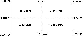
图1是本发明全经纬度范围的说明图;Fig. 1 is the explanatory figure of the whole longitude and latitude scope of the present invention;
图2是本发明一个拓扑层的坐标关系构造方法的说明图;Fig. 2 is an explanatory diagram of the coordinate relationship construction method of a topological layer of the present invention;
图3是本发明任意一个点P的坐标表示和比例关系说明图;Fig. 3 is the coordinate representation of any point P of the present invention and the explanatory diagram of proportional relationship;
图4是本发明任意一个点P在任意两个拓扑层之间的坐标关系说明图。Fig. 4 is an explanatory diagram of the coordinate relationship between any point P between any two topological layers in the present invention.
具体实施方式:Detailed ways:
本发明按下述步骤完成层次化拓扑网络地理信息展示:The present invention completes the display of hierarchical topological network geographic information according to the following steps:
步骤1:根据拓扑对象在物理空间的分布状况,构造拓扑网络的层次结构;Step 1: According to the distribution of topological objects in physical space, construct the hierarchical structure of topological network;
步骤2:对于层次结构中的每一个拓扑层,包括一个背景地图层和拓扑信息的节点、链路的拓扑对象层;Step 2: For each topology layer in the hierarchy, include a background map layer and a node and link topology object layer for topology information;
步骤3:构造一个经纬度坐标系,使各拓扑层都采用这个经纬度坐标系;Step 3: Construct a latitude-longitude coordinate system, so that each topological layer adopts this latitude-longitude coordinate system;
步骤4:构造各个拓扑层的自身的笛卡尔坐标系和背景地图的范围;Step 4: Construct the range of its own Cartesian coordinate system and background map of each topological layer;
步骤5:构造每个拓扑层中包含的各个节点的坐标点;Step 5: Construct the coordinate points of each node contained in each topology layer;
步骤6:在计算机上展示各个拓扑层。Step 6: Display each topology layer on the computer.
下面进行详细说明:The details are as follows:
首先给出地理信息的有关概念的定义,以方便描述本发明所阐述的拓扑网络地理信息展示方法。Firstly, the definitions of related concepts of geographic information are given to facilitate the description of the method for displaying topological network geographic information in the present invention.
定义1 经度、纬度的数值表示:Definition 1 Numerical representation of longitude and latitude:
一个经纬度通常使用度、分、秒来表示的,这种方式由于不是数值化的,给计算带来不便。这里给出经度或者纬度数值化表示的方法:A latitude and longitude is usually represented by degrees, minutes, and seconds. This method brings inconvenience to calculations because it is not numerical. Here is the method of numerical representation of longitude or latitude:
全经度范围是[-180,180]的区间,任何一个经度值都在这个区间内,即J={Jx|Jx∈[-180,180]},其子集区间[-180,0]表示西经,子集区间[0,180]表示东经。特别地,经度值为0表示格林尼治本初子午线。经度值-180同180在经度上实际上是重合的。The full longitude range is the interval [-180, 180], any longitude value is in this interval, that is, J={Jx|Jx∈[-180, 180]}, and its subset interval [-180, 0] means West longitude, the subset interval [0, 180] represents east longitude. In particular, a longitude value of 0 represents the Greenwich prime meridian. Longitude values -180 and 180 are actually coincident in longitude.
全纬度范围是[90,-90]的区间,任何一个纬度值都在这个区间内,即W={Wy|Wy∈[90,-90]},其子集区间[90,0]表示北纬,子集区间[0,-90]表示南纬。特别地,纬度值为0表示赤道线,纬度值为90表示北极,纬度值为-90表示南极。The full latitude range is the interval of [90, -90], and any latitude value is within this interval, that is, W={Wy|Wy∈[90, -90]}, and its subset interval [90, 0] represents the northern latitude , the subset interval [0, -90] represents the southern latitude. In particular, a latitude value of 0 represents the equator, a latitude value of 90 represents the North Pole, and a latitude value of -90 represents the South Pole.
在这种表示下,任何一个位置点P可以使用经纬度的二元组:<Jx,Wy>表示。例如<-150,50>表示西经为150度、北纬为50度的点。Under this representation, any position point P can be represented by a two-tuple of latitude and longitude: <Jx, Wy>. For example, <-150, 50> means the point where the west longitude is 150 degrees and the north latitude is 50 degrees.
举例说明全经纬度范围的表示,附图1的矩形区域表示全经纬度范围,它分成四个区域:西经北纬区域、东经北纬区域,西经南纬区域、东经南纬区域。把经纬度进行数值化后,就可以方便地计算点与点之间的位置关系了。To illustrate the representation of the full range of longitude and latitude, the rectangular area of Figure 1 represents the full range of longitude and latitude, which is divided into four areas: the west longitude and north latitude area, the east longitude and north latitude area, the west longitude and south latitude area, and the east longitude and south latitude area. After numericalizing the latitude and longitude, the positional relationship between points can be easily calculated.
定义2 背景地图的范围,地图经度偏移量,地图纬度偏移量:Definition 2 The range of the background map, the longitude offset of the map, and the latitude offset of the map:
背景地图的范围是一个六元组:<Js,Je,Ws,We,w,h>,其中Js表示背景地图起始经度,Je表示结束经度,Ws表示起始纬度,We表示结束纬度,w和h是背景地图的宽度和高度,-180<=Js<=180,-180<=Je<=180,Js≠Je,90>=Ws>We>=-90。背景地图的起始经纬度的位置点表示<Js,Ws>,结束经纬度的位置点表示为<Je,We>;The range of the background map is a six-tuple: <Js, Je, Ws, We, w, h>, where Js represents the starting longitude of the background map, Je represents the ending longitude, Ws represents the starting latitude, We represents the ending latitude, w and h are the width and height of the background map, -180<=Js<=180, -180<=Je<=180, Js≠Je, 90>=Ws>We>=-90. The position point of the starting latitude and longitude of the background map is expressed as <Js, Ws>, and the position point of the ending latitude and longitude is expressed as <Je, We>;
地图经度偏移量用|ΔJ|表示,如果Je-Js>0,则取|ΔJ|=Je-Js,否则取|ΔJ|=(Je-Js)+360;The map longitude offset is represented by |ΔJ|, if Je-Js>0, take |ΔJ|=Je-Js, otherwise take |ΔJ|=(Je-Js)+360;
地图纬度偏移量用|ΔW|表示,且|ΔW|=Ws-We;The map latitude offset is represented by |ΔW|, and |ΔW|=Ws-We;
当背景地图携带地图时,Js,Je,Ws,We可以指派,例如Js取30,Je取60,Ws取60,We取20,而宽度w和高度h则直接取地图本身的宽度和高度即可。When the background map carries a map, Js, Je, Ws, We can be assigned, for example, Js takes 30, Je takes 60, Ws takes 60, We takes 20, and the width w and height h directly take the width and height of the map itself, that is Can.
当背景地图只是一个空的背景时,则需要指派六元组的各个值。When the background map is just an empty background, each value of the six-tuple needs to be assigned.
定义3 一个拓扑层的笛卡儿坐标系的表示:Definition 3 The representation of the Cartesian coordinate system of a topological layer:
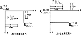
背景地图的起始经纬度的位置点<Js,Ws>对应于该拓扑层自身笛卡尔坐标系的原点O(O,O),结束经纬度的位置点<Je,We>对应于笛卡尔坐标系的点B(w,h)。由这两点,可以确定整个笛卡儿坐标系。附图2直观地表达了由地图范围六元组:<Js,Je,Ws,We,w,h>来构造一个拓扑层的笛卡儿坐标系。The position point <Js, Ws> of the starting latitude and longitude of the background map corresponds to the origin O(O, O) of the Cartesian coordinate system of the topology layer itself, and the position point <Je, We> of the ending latitude and longitude corresponds to the Cartesian coordinate system Point B(w,h). From these two points, the entire Cartesian coordinate system can be determined. Attached Figure 2 intuitively expresses the Cartesian coordinate system of a topological layer constructed by the six-tuple of map range: <Js, Je, Ws, We, w, h>.
根据定义3,它确定了一个拓扑层下笛卡儿坐标系同经纬度坐标系之间的关系,这个笛卡儿坐标系是该拓扑层自身的,而这个经纬度坐标系则是各个拓扑层都共同采用的。According to definition 3, it determines the relationship between the Cartesian coordinate system and the latitude and longitude coordinate system under a topology layer. The Cartesian coordinate system is the topology layer itself, and the latitude and longitude coordinate system is the common adopted.
在上面经纬度坐标表示、地图范围、拓扑图层笛卡儿坐标系表示的定义下,下面给出从经纬度数值计算其度分秒的换算方法、经纬度坐标与笛卡儿坐标之间的换算方法、以及不同拓扑层之间坐标的换算方法。Under the above definition of latitude and longitude coordinate representation, map range, and topological layer Cartesian coordinate system representation, the conversion method for calculating degrees, minutes and seconds from latitude and longitude values, the conversion method between latitude and longitude coordinates and Cartesian coordinates, And the conversion method of coordinates between different topological layers.
首先是一个坐标点相对地图的比例关系:The first is the proportional relationship of a coordinate point relative to the map:
1、一个坐标点相对地图的比例关系:1. The proportional relationship of a coordinate point relative to the map:
一个点P的笛卡儿坐标点为(x,y),其经纬度坐标点为<Jx,Wy>,如附图3,不管点P在地图内部还是外部,其在X方向上的笛卡儿坐标偏移为x,经度偏移为ΔJxs,在Y方向上笛卡儿坐标偏移为y,纬度偏移为ΔWys。这些偏移是有方向的,因此可能是正数值,也可能为负数值,或者0。因此偏移x同地图宽度w的比值必然等同于经度偏移ΔJxs同地图经度偏移量|ΔJ|的比值,偏移y同地图高度h的比值必然等同于纬度偏移ΔWys同地图纬度偏移量|ΔW|的比值,即有如下两式:The Cartesian coordinate point of a point P is (x, y), and its latitude and longitude coordinate point is <Jx, Wy>, as shown in Figure 3, regardless of whether point P is inside or outside the map, its Cartesian coordinate point in the X direction The coordinate offset is x, the longitude offset is ΔJxs, the Cartesian coordinate offset in the Y direction is y, and the latitude offset is ΔWys. These offsets are directional, so may be positive or negative, or 0. Therefore, the ratio of offset x to map width w must be equal to the ratio of longitude offset ΔJxs to map longitude offset |ΔJ|, and the ratio of offset y to map height h must be equal to latitude offset ΔWys to map latitude offset The ratio of the quantity |ΔW| has the following two formulas:
(1)x/w=ΔJxs/|ΔJ|(1) x/w=ΔJxs/|ΔJ|
(2)y/h=ΔWys/|ΔW|(2) y/h=ΔWys/|ΔW|
其中经度偏移ΔJxs由点P的经度值Jx和地图起始经度值Js决定:The longitude offset ΔJxs is determined by the longitude value Jx of point P and the starting longitude value Js of the map:
ΔJxs=Jx-Js;ΔJxs=Jx-Js;
其中纬度偏移ΔWys由点P的纬度值Wy和地图起始纬度值Ws决定:The latitude offset ΔWys is determined by the latitude value Wy of point P and the starting latitude value Ws of the map:
ΔWys=Wy-Ws;ΔWys=Wy-Ws;
下面是在一个拓扑层内一个点的笛卡儿坐标同其经纬度坐标之间的对应关系,这些方法都用到了上述1中给出的比例关系,取笛卡尔坐标系任意一点(x,y),对应在经纬度系下的坐标<Jx,Wy>:The following is the correspondence between the Cartesian coordinates of a point in a topological layer and its latitude and longitude coordinates. These methods all use the proportional relationship given in 1 above, and take any point in the Cartesian coordinate system (x, y) , corresponding to the coordinates <Jx, Wy> in the latitude-longitude system:
2、x坐标与经度Jx坐标的对应关系:2. Correspondence between x coordinates and longitude Jx coordinates:
步骤1:根据比例关系,x/w=(Jx-Js)/|ΔJ|,得Jx=Js+|ΔJ|×x/w;Step 1: According to the proportional relationship, x/w=(Jx-Js)/|ΔJ|, get Jx=Js+|ΔJ|×x/w;
步骤2:如果Jx<-180,使Jx=Jx+360;一直重复这个步骤直到Jx在[-180,180]的范围内;Step 2: If Jx<-180, make Jx=Jx+360; repeat this step until Jx is in the range of [-180, 180];
步骤3:如果Jx>180,使Jx=Jx-360;一直重复这个步骤直到Jx在[-180,180]的范围内;Step 3: If Jx>180, make Jx=Jx-360; Repeat this step until Jx is in the range of [-180,180];
3、经度坐标Jx与x坐标的对应关系:3. Correspondence between longitude coordinate Jx and x coordinate:
步骤1:经度坐标的偏移ΔJxs=Jx-Js;Step 1: Offset of longitude coordinates ΔJxs=Jx-Js;
步骤2:如果ΔJxs<0,使ΔJxs=ΔJxs+360;此时ΔJxs>=0;Step 2: If ΔJxs<0, make ΔJxs=ΔJxs+360; at this time ΔJxs>=0;
步骤3:根据比例关系,x/w=ΔJxs/|ΔJ|,得x=w×ΔJxs/|ΔJ|;Step 3: According to the proportional relationship, x/w=ΔJxs/|ΔJ|, get x=w×ΔJxs/|ΔJ|;
4、y坐标与纬度Wy坐标的对应关系:4. Correspondence between y coordinates and latitude Wy coordinates:
步骤1:根据比例关系,y/h=(Wy-Ws)/|ΔW|,得Wy=Ws+|ΔW|×y/h;Step 1: According to the proportional relationship, y/h=(Wy-Ws)/|ΔW|, get Wy=Ws+|ΔW|×y/h;
步骤2:如果Wy<-90,使Wy=Wy+180;一直重复这个步骤直到Wy在[90,-90]的范围内:Step 2: If Wy<-90, make Wy=Wy+180; repeat this step until Wy is in the range of [90,-90]:
步骤3:如果Wy>90,使Wy=Wy-180;一直重复这个步骤直到Wy在[90,-90]的范围内;Step 3: if Wy>90, make Wy=Wy-180; repeat this step until Wy is in the range of [90,-90];
5、纬度Wy与y坐标的对应关系:5. Correspondence between latitude Wy and y coordinates:
步骤1:计算纬度坐标的偏移ΔWys=Ws-Wy;Step 1: Calculate the offset ΔWys=Ws-Wy of the latitude coordinates;
步骤2:根据比例关系,y/h=ΔWys/|ΔW|,得y=h×ΔWys/|ΔW|;Step 2: According to the proportional relationship, y/h=ΔWys/|ΔW|, get y=h×ΔWys/|ΔW|;
上述2和4中将一个点的笛卡儿坐标(x,y)与其经纬度坐标<Jx,Wy>对应,3和5则把经纬度坐标<Jx,Wy>与笛卡儿坐标(x,y)对应。注意,上述2和3并不是可逆的,这是因为笛卡儿坐标在x方向上是单向延伸的,而经度的范围总是固定在[-180,180]的范围内,因此有无穷多个不同的x坐标都对应同一个经度值。同样地,4和5也不是可逆的,也有无穷多个不同的y坐标都对应同一个纬度值。3和5总是把固定的经纬度坐标对应成固定的笛卡儿坐标(x’,y’),这样的笛卡儿坐标点称为正则笛卡儿坐标点。In the above 2 and 4, the Cartesian coordinates (x, y) of a point correspond to its latitude and longitude coordinates <Jx, Wy>, and in 3 and 5, the latitude and longitude coordinates <Jx, Wy> are compared with the Cartesian coordinates (x, y) correspond. Note that the above 2 and 3 are not reversible, this is because Cartesian coordinates extend in one direction in the x direction, and the range of longitude is always fixed in the range of [-180, 180], so there are infinitely many different x-coordinates all correspond to the same longitude value. Similarly, 4 and 5 are not reversible, and there are infinitely many different y coordinates corresponding to the same latitude value. 3 and 5 always correspond fixed latitude and longitude coordinates to fixed Cartesian coordinates (x', y'), and such Cartesian coordinate points are called regular Cartesian coordinate points.
在实际应用中,不可能把笛卡儿坐标做成无限大,应该给一定限定范围,例如只允许正则笛卡儿坐标点所组成的集合。In practical applications, it is impossible to make the Cartesian coordinates infinite, and a certain limit should be given, for example, only a set of regular Cartesian coordinate points is allowed.
在一个拓扑层内的的各个节点(如网元、子网或其它设备资源)的坐标既可以采用笛卡儿坐标表示其位置属性,也可以用经纬度坐标表示其位置属性,两者按照上面的对应关系实际是等价的,可以从一个坐标系得到得到另外一个坐标系下的坐标。The coordinates of each node (such as a network element, subnet or other equipment resources) in a topology layer can use Cartesian coordinates to represent its location attributes, or use latitude and longitude coordinates to represent its location attributes, both according to the above The corresponding relationship is actually equivalent, and the coordinates in another coordinate system can be obtained from one coordinate system.
在实际应用中,经常把一个节点从一个拓扑层移动到另外一个拓扑层,为了保持其物理位置不变,需要定义不同的拓扑层之间的坐标对应关系。In practical applications, a node is often moved from one topological layer to another. In order to keep its physical location unchanged, it is necessary to define the coordinate correspondence between different topological layers.
6、任意两个拓扑层A和B,从A的笛卡儿坐标得到B的笛卡儿坐标:6. For any two topological layers A and B, get the Cartesian coordinates of B from the Cartesian coordinates of A:
步骤1:拓扑层A中任何一点(x,y)根据上述2和4,得到该位置点的经纬度坐标<Jx,Wy>;Step 1: Any point (x, y) in topological layer A obtains the longitude and latitude coordinates <Jx, Wy> of the point according to the above 2 and 4;
步骤2:再根据上述3和5,从该经纬度坐标<Jx,Wy>得到拓扑层B中对应的笛卡尔坐标点(x’,y’)。Step 2: According to the above 3 and 5, obtain the corresponding Cartesian coordinate point (x', y') in the topology layer B from the latitude and longitude coordinate <Jx, Wy>.
不同的拓扑层之间坐标的对应关系有实际的用途,意义在于当一个拓扑层内的一个节点移动到另外一个拓扑层内时,根据上述6就可以得到该节点从原来所属的拓扑层的笛卡儿坐标得到新的拓扑层的笛卡儿坐标。附图4以图形的方式表现了把一个拓扑节点a从拓扑层A移动到拓扑层B,只要保持它的经纬度不变,那么把它移动到拓扑层B后该节点的位置就可以确定下来,并在层B中显示该节点。The corresponding relationship of coordinates between different topological layers has practical uses. The meaning is that when a node in one topological layer moves to another topological layer, according to the above 6, the node can be obtained from the original topological layer. Cartesian coordinates Get the Cartesian coordinates of the new topology layer. Figure 4 graphically represents the movement of a topological node a from topological layer A to topological layer B. As long as its latitude and longitude remain unchanged, the position of the node can be determined after it is moved to topological layer B. and display the node in layer B.
前面是在经纬度坐标进行数值化的方式下的坐标对应关系,但在最终展现给用户时,数值化的经纬度不容易理解,因此需要提供它们与度、分、秒的对应关系。The above is the coordinate correspondence in the way of numericalizing the latitude and longitude coordinates, but when it is finally displayed to the user, the numerical latitude and longitude are not easy to understand, so it is necessary to provide their correspondence with degrees, minutes, and seconds.
7、任意一个经度得到它的度、分、秒:7. Obtain its degrees, minutes, and seconds for any longitude:
步骤1:度数取经度的整数部分,如果小于0表示西经,大于0表示东经;Step 1: Take the integer part of the longitude in degrees, if it is less than 0, it means west longitude, and if it is greater than 0, it means east longitude;
步骤2:分数取经度的小数部分,再剩以60,得到的数值r取整数部分;Step 2: Take the fractional part of the longitude as the score, and then divide it with 60, and take the integer part of the obtained value r;
步骤3:秒数取步骤2中所得数值r取小数部分,再剩以60,得到的数值s,取整数部分;也可以取数值s对整数的四舍五入。二者取其一都可以。Step 3: Take the value r obtained in step 2 for the number of seconds, take the fractional part, and then divide it by 60, and take the integer part of the obtained value s; you can also use the rounding of the value s to the integer. Either of the two is fine.
举一个经度为-150.836294为例:Take a longitude of -150.836294 as an example:
按照步骤1,得到度数为-150,因此是西经150度;According to step 1, the obtained degree is -150, so it is 150 degrees west longitude;
按照步骤2,分数取小数部分0.836294,再×60=50.17746,再取整数部分50,即分数为50分;According to step 2, the fractional part of the score is 0.836294, then × 60 = 50.17746, and then the integer part is 50, that is, the score is 50 points;
按照步骤3,秒数取步骤2中小数部分0.17746,再×60=10.6476,再取整数部分10,即秒数为10秒;或者取对整数的四舍五入的值11,二者取其一都可以。According to step 3, the fractional part of the second is 0.17746 in step 2, then ×60=10.6476, and then the integer part is 10, that is, the second is 10 seconds; or the rounded value of the integer is 11, either of which can be used .
8、任意一个纬度得到它的度、分、秒:8. Obtain its degrees, minutes, and seconds for any latitude:
步骤1:度数取纬度的整数部分,如果小于0表示南纬,大于0表示北纬;Step 1: The degree takes the integer part of latitude, if it is less than 0, it means south latitude, and if it is greater than 0, it means north latitude;
步骤2:分数取经度的小数部分,再剩以60,得到的数值r取整数部分;Step 2: Take the fractional part of the longitude as the score, and then divide it with 60, and take the integer part of the obtained value r;
步骤3:秒数取步骤2中所得数值r取小数部分,再剩以60,得到的数值s,取整数部分;也可以取数值s对整数的四舍五入。二者取其一都可以。Step 3: Take the value r obtained in step 2 for the number of seconds, take the fractional part, and then divide it by 60, and take the integer part of the obtained value s; you can also use the rounding of the value s to the integer. Either of the two is fine.
举一个经度为-57.836294为例:Take a longitude of -57.836294 as an example:
按照步骤1,得到度数为-57,因此是南纬57度;According to step 1, the obtained degree is -57, so it is 57 degrees south latitude;
按照步骤2,分数取小数部分0.836294,再×60=50.17746,再取整数部分50,即分数为50分;According to step 2, the fractional part of the score is 0.836294, then × 60 = 50.17746, and then the integer part is 50, that is, the score is 50 points;
按照步骤3,秒数取步骤2中小数部分0.17746,再×60=10.6476,再取整数部分10,即秒数为10秒;或者取对整数的四舍五入的值11,二者取其一都可以。According to step 3, the fractional part of the second is 0.17746 in step 2, then ×60=10.6476, and then the integer part is 10, that is, the second is 10 seconds; or the rounded value of the integer is 11, either of which can be used .
在实际应用中,数据的输入可能是以度、分、秒的方式提供的,因此还需要提供度、分、秒与经纬度的数值的对应关系。In practical applications, data input may be provided in degrees, minutes, and seconds, so it is also necessary to provide the corresponding relationship between degrees, minutes, seconds and latitude and longitude values.
9、从任意经度(或者纬度)的度、分、秒得其数值:9. Obtain the value from the degrees, minutes, and seconds of any longitude (or latitude):
步骤1:从秒数计算度数值,度数值为分数除以60再除以100;Step 1: Calculate the degree value from the seconds, the degree value is the fraction divided by 60 and then divided by 100;
步骤2:从分数计算度数值,度数值为分数除以60;Step 2: Calculate the degree value from the fraction, the degree value is the fraction divided by 60;
步骤3:从度数计算度数值,则度数值就是该度数;Step 3: Calculate the degree value from the degree, then the degree value is the degree;
步骤4:经度值(纬度值)取上面三个步骤的和,即度分秒分别换算的度数值想加得到的值,如果为西经(南纬),则取值为负数,如果为东经(北纬),则为正数。Step 4: The longitude value (latitude value) takes the sum of the above three steps, that is, the value you want to add to the degree value converted from degrees, minutes and seconds. If it is west longitude (south latitude), the value is negative, and if it is east longitude (northern latitude), it is a positive number.
Claims (9)


Priority Applications (1)
| Application Number | Priority Date | Filing Date | Title |
|---|---|---|---|
| CN 200410065401 CN1780285A (en) | 2004-11-28 | 2004-11-28 | Hierarchical topological network geographic information displaying method |
Applications Claiming Priority (1)
| Application Number | Priority Date | Filing Date | Title |
|---|---|---|---|
| CN 200410065401 CN1780285A (en) | 2004-11-28 | 2004-11-28 | Hierarchical topological network geographic information displaying method |
Publications (1)
| Publication Number | Publication Date |
|---|---|
| CN1780285A true CN1780285A (en) | 2006-05-31 |
Family
ID=36770395
Family Applications (1)
| Application Number | Title | Priority Date | Filing Date |
|---|---|---|---|
| CN 200410065401 Pending CN1780285A (en) | 2004-11-28 | 2004-11-28 | Hierarchical topological network geographic information displaying method |
Country Status (1)
| Country | Link |
|---|---|
| CN (1) | CN1780285A (en) |
Cited By (9)
| Publication number | Priority date | Publication date | Assignee | Title |
|---|---|---|---|---|
| CN100454848C (en) * | 2007-03-07 | 2009-01-21 | 华为技术有限公司 | A method for topology layout of network structure and network management equipment |
| CN1921410B (en) * | 2006-09-06 | 2010-05-12 | 华为技术有限公司 | Device and method for displaying network element location and method for monitoring network status |
| CN101217410B (en) * | 2008-01-07 | 2010-08-25 | 杭州华三通信技术有限公司 | Method and device for displaying network topology |
| CN101202670B (en) * | 2007-12-21 | 2011-04-06 | 中兴通讯股份有限公司 | Method and system for processing network management topology |
| CN102111875A (en) * | 2011-01-10 | 2011-06-29 | 浙江大学 | Parallel positioning method for numerous discrete nodes |
| CN101631047B (en) * | 2009-07-20 | 2012-01-11 | 南京联创科技集团股份有限公司 | Network topology structure showing method based on plane mode |
| CN102932201A (en) * | 2012-09-26 | 2013-02-13 | 迈普通信技术股份有限公司 | Display control system and method for network monitoring data |
| US9210047B2 (en) | 2012-01-11 | 2015-12-08 | Huawei Technologies Co., Ltd. | Method and apparatus for presenting network path |
| CN113032507A (en) * | 2021-03-22 | 2021-06-25 | 湖南汽车工程职业学院 | Geographic information cloud storage system based on plop structure |
-
2004
- 2004-11-28 CN CN 200410065401 patent/CN1780285A/en active Pending
Cited By (10)
| Publication number | Priority date | Publication date | Assignee | Title |
|---|---|---|---|---|
| CN1921410B (en) * | 2006-09-06 | 2010-05-12 | 华为技术有限公司 | Device and method for displaying network element location and method for monitoring network status |
| CN100454848C (en) * | 2007-03-07 | 2009-01-21 | 华为技术有限公司 | A method for topology layout of network structure and network management equipment |
| CN101202670B (en) * | 2007-12-21 | 2011-04-06 | 中兴通讯股份有限公司 | Method and system for processing network management topology |
| CN101217410B (en) * | 2008-01-07 | 2010-08-25 | 杭州华三通信技术有限公司 | Method and device for displaying network topology |
| CN101631047B (en) * | 2009-07-20 | 2012-01-11 | 南京联创科技集团股份有限公司 | Network topology structure showing method based on plane mode |
| CN102111875A (en) * | 2011-01-10 | 2011-06-29 | 浙江大学 | Parallel positioning method for numerous discrete nodes |
| CN102111875B (en) * | 2011-01-10 | 2013-10-16 | 浙江大学 | Parallel positioning method for numerous discrete nodes |
| US9210047B2 (en) | 2012-01-11 | 2015-12-08 | Huawei Technologies Co., Ltd. | Method and apparatus for presenting network path |
| CN102932201A (en) * | 2012-09-26 | 2013-02-13 | 迈普通信技术股份有限公司 | Display control system and method for network monitoring data |
| CN113032507A (en) * | 2021-03-22 | 2021-06-25 | 湖南汽车工程职业学院 | Geographic information cloud storage system based on plop structure |
Similar Documents
| Publication | Publication Date | Title |
|---|---|---|
| Dietzel et al. | Spatio‐temporal dynamics in California's Central Valley: Empirical links to urban theory | |
| CN102609525B (en) | Method for dissecting and unifying geographic grid based on longitude and latitude | |
| CN101963996B (en) | Global raster data storing method | |
| CN101075248A (en) | System and method for providing geographical information system interface service | |
| US20100042938A1 (en) | Interactive Navigation of a Dataflow Process Image | |
| JP2010504560A (en) | Method and system for displaying graphic objects on a digital map | |
| CN1780285A (en) | Hierarchical topological network geographic information displaying method | |
| CN103886032A (en) | Geographic information model and building information model integrated associated index component method | |
| CN116011322B (en) | Urban information display method, device, equipment and medium based on digital twin | |
| CN115935060A (en) | Screening method, device and computer equipment for dot layout position | |
| CN113077181A (en) | Parking station setting method, device, medium and electronic equipment | |
| CN1570910A (en) | A universal object modeling method and universal object management system | |
| CN116414930A (en) | Place name category vector slicing-free visualization method, device, equipment and medium | |
| Bast et al. | Metro maps on flexible base grids | |
| CN1658190A (en) | Method and system for acquiring traffic information | |
| CN100336062C (en) | Information presentation system | |
| CN105138724A (en) | Universal extendable open simulation scenario editing method and apparatus | |
| CN117827996A (en) | Tile image map processing method, device and equipment | |
| CN112604283A (en) | Data rendering method and device | |
| CN1921410A (en) | Device and method for exhibiting network element position and method for monitoring state of network | |
| CN101763659B (en) | Method for automatically generating large-scale digitization altitude data model based on image set | |
| CN1929393A (en) | A three-state tree presentation and positioning method for network element objects in a network optimization system | |
| CN118967948B (en) | Three-dimensional scene programming modeling method and device | |
| CN101359341B (en) | A Scale Setting Method Based on Vector Data Information Amount | |
| CN118898671A (en) | Method and system for realizing seamless roaming of all scenic spots based on street view map |
Legal Events
| Date | Code | Title | Description |
|---|---|---|---|
| C06 | Publication | ||
| PB01 | Publication | ||
| C10 | Entry into substantive examination | ||
| SE01 | Entry into force of request for substantive examination | ||
| C12 | Rejection of a patent application after its publication | ||
| RJ01 | Rejection of invention patent application after publication |
Open date: 20060531 |