EP0093767B1 - Procede de determination des perturbations atmospheriques au niveau de la source et du recepteur dans le domaine de l'exploration sismique marine - Google Patents
Procede de determination des perturbations atmospheriques au niveau de la source et du recepteur dans le domaine de l'exploration sismique marine Download PDFInfo
- Publication number
- EP0093767B1 EP0093767B1 EP83900096A EP83900096A EP0093767B1 EP 0093767 B1 EP0093767 B1 EP 0093767B1 EP 83900096 A EP83900096 A EP 83900096A EP 83900096 A EP83900096 A EP 83900096A EP 0093767 B1 EP0093767 B1 EP 0093767B1
- Authority
- EP
- European Patent Office
- Prior art keywords
- seismic
- detector cable
- low velocity
- near surface
- velocity layer
- Prior art date
- Legal status (The legal status is an assumption and is not a legal conclusion. Google has not performed a legal analysis and makes no representation as to the accuracy of the status listed.)
- Expired
Links
- 230000003068 static effect Effects 0.000 title claims description 34
- 238000000034 method Methods 0.000 title claims description 14
- 230000002547 anomalous effect Effects 0.000 claims abstract description 4
- XLYOFNOQVPJJNP-UHFFFAOYSA-N water Substances O XLYOFNOQVPJJNP-UHFFFAOYSA-N 0.000 claims description 6
- 239000013049 sediment Substances 0.000 description 12
- 230000015572 biosynthetic process Effects 0.000 description 5
- 238000005755 formation reaction Methods 0.000 description 5
- 238000012937 correction Methods 0.000 description 4
- 230000001934 delay Effects 0.000 description 2
- 230000000694 effects Effects 0.000 description 1
- 230000008030 elimination Effects 0.000 description 1
- 238000003379 elimination reaction Methods 0.000 description 1
- 238000005259 measurement Methods 0.000 description 1
- 230000003252 repetitive effect Effects 0.000 description 1
Images

Classifications
-
- G—PHYSICS
- G01—MEASURING; TESTING
- G01V—GEOPHYSICS; GRAVITATIONAL MEASUREMENTS; DETECTING MASSES OR OBJECTS; TAGS
- G01V13/00—Manufacturing, calibrating, cleaning, or repairing instruments or devices covered by groups G01V1/00 – G01V11/00
-
- G—PHYSICS
- G01—MEASURING; TESTING
- G01V—GEOPHYSICS; GRAVITATIONAL MEASUREMENTS; DETECTING MASSES OR OBJECTS; TAGS
- G01V1/00—Seismology; Seismic or acoustic prospecting or detecting
- G01V1/28—Processing seismic data, e.g. for interpretation or for event detection
- G01V1/36—Effecting static or dynamic corrections on records, e.g. correcting spread; Correlating seismic signals; Eliminating effects of unwanted energy
- G01V1/362—Effecting static or dynamic corrections; Stacking
-
- G—PHYSICS
- G01—MEASURING; TESTING
- G01V—GEOPHYSICS; GRAVITATIONAL MEASUREMENTS; DETECTING MASSES OR OBJECTS; TAGS
- G01V1/00—Seismology; Seismic or acoustic prospecting or detecting
- G01V1/38—Seismology; Seismic or acoustic prospecting or detecting specially adapted for water-covered areas
- G01V1/3808—Seismic data acquisition, e.g. survey design
-
- G—PHYSICS
- G01—MEASURING; TESTING
- G01V—GEOPHYSICS; GRAVITATIONAL MEASUREMENTS; DETECTING MASSES OR OBJECTS; TAGS
- G01V2210/00—Details of seismic processing or analysis
- G01V2210/50—Corrections or adjustments related to wave propagation
- G01V2210/53—Statics correction, e.g. weathering layer or transformation to a datum
Definitions
- This invention relates to a method for determining source and receiver statics in marine seismic exploration.
- Some marine exploration areas are characterized by severe statics problems caused by the existence of a variety of subaqueous features and other sea floor irregularities. Such anomalies generally lie immediately below the water bottom and contain sediments having abnormally low velocities relative to normal sediments at shallow depths. They characteristically resemble channels ranging in depth up to a few hundred meters (feet) and lateral extent from a few hundred meters (feet) to thousands of meters (feet). Velocities in these sediments are commonly less than half that of normal sediments. This decrease in velocity is due to gas bubbles in the sediment, causing a time delay in seismic energy waves traveling through the sediment relative to seismic energy waves traveling the same distance through normal sediments.
- One such marine exploration area is near the modern Mississippi River delta.
- the present invention resides in a method for determining source and receiver statics at a marine exploration site having an anomalous near surface low velocity layer below the water bottom, comprising the steps of:
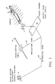
- exploration is carried out with a seismic detector cable 14 fixed in position on the water bottom and extending along a seismic exploration line.
- Seismic energy is generated in the water by a source 11 towed by a marine vessel 10 and reflections of the energy from subsurface formations are detected by hydrophones located along the cable 14. The detected signals are then transferred to the marine vessel through the cable wiring for recording and processing. If a hydrophone overlies an anomalous layer of low velocity sediments, an undesirable receiver statics effect will be imposed on the seismic reflection signals. Also, if the seismic energy source is energized over such a low velocity sediment, undesirable source statics will be recorded in the seismic reflection signals.
- FIG. 1 which illustrates determination of source statics
- seismic energy waves from the source 11 are shown as travelling downward through the water and passing into a subsurface formation through a low velocity sediment in a buried channel 12. Reflections of the seismic energy from the subsurface formation travel upward by way of path 13 and are received by the on-bottom seismic detector cable 14.
- the seismic energy waves are also refracted along a path 16 and received and recorded by the remote monitor 15 simultaneously with the recording of the seismic reflection signals by the detector cable 14.
- a suitable source-to-remote monitor offset will be in the order of 5000-8333 m (15,000-25,000 feet).
- the recorded refraction data may then be compared with the recorded reflection data to determine the low velocity layer statics for each source location during the exploration operation.
- the vessel 10 locates the seismic energy source at an offset from the detector cable 14 so that the seismic energy waves from the source travel through refraction paths in the subsurface formations upward through the channel 12 and then intersect the cable 14 from a generally broadside or orthogonal direction.
- the first refraction arrivals recorded by the hydrophones in the cable 14 are compared to conventionally recorded refraction data from non-low velocity layer areas to determine the receiver statics for the selected exploration site.
- Corrections to the recorded seismic reflection data are then carried out by removing the distortions caused by such source and receiver statics introduced by the low velocity sediments in the buried channel at the selected exploration site.
- the seismic exploration system may be of the type described in U.S. Patent No. 2,590,531 wherein the seismic detector cable is deployed on the ocean bottom from a first marine vessel while the seismic energy source is deployed from a second marine vessel.
- a suitable seismic energy source produces repetitive pulses of seismic energy from an air gun and is described in U.S. Patent No. 3,687,218.
- An on-bottom seismic receiver system that is particularly suitable for use as the remote seismic monitor 15 for refraction measurements is disclosed in U.S. Patent application Serial No. 163,757, filed June 27,1980, to Bowden et al.
Landscapes
- Life Sciences & Earth Sciences (AREA)
- Physics & Mathematics (AREA)
- Engineering & Computer Science (AREA)
- Geophysics (AREA)
- General Life Sciences & Earth Sciences (AREA)
- General Physics & Mathematics (AREA)
- Remote Sensing (AREA)
- Acoustics & Sound (AREA)
- Environmental & Geological Engineering (AREA)
- Geology (AREA)
- Manufacturing & Machinery (AREA)
- Oceanography (AREA)
- Geophysics And Detection Of Objects (AREA)
- Measurement Of Velocity Or Position Using Acoustic Or Ultrasonic Waves (AREA)
Claims (3)
Applications Claiming Priority (2)
| Application Number | Priority Date | Filing Date | Title |
|---|---|---|---|
| US06/320,286 US4415997A (en) | 1981-11-12 | 1981-11-12 | Method for determining source and receiver statics in marine seismic exploration |
| US320286 | 1994-10-11 |
Publications (3)
| Publication Number | Publication Date |
|---|---|
| EP0093767A1 EP0093767A1 (fr) | 1983-11-16 |
| EP0093767A4 EP0093767A4 (fr) | 1985-06-26 |
| EP0093767B1 true EP0093767B1 (fr) | 1988-03-30 |
Family
ID=23245719
Family Applications (1)
| Application Number | Title | Priority Date | Filing Date |
|---|---|---|---|
| EP83900096A Expired EP0093767B1 (fr) | 1981-11-12 | 1982-10-28 | Procede de determination des perturbations atmospheriques au niveau de la source et du recepteur dans le domaine de l'exploration sismique marine |
Country Status (5)
| Country | Link |
|---|---|
| US (1) | US4415997A (fr) |
| EP (1) | EP0093767B1 (fr) |
| CA (1) | CA1181159A (fr) |
| NO (1) | NO832294L (fr) |
| WO (1) | WO1983001839A1 (fr) |
Cited By (1)
| Publication number | Priority date | Publication date | Assignee | Title |
|---|---|---|---|---|
| WO2017024536A1 (fr) * | 2015-08-11 | 2017-02-16 | 深圳朝伟达科技有限公司 | Procédé d'élimination automatique d'arrivée d'onde d'onde sismique |
Families Citing this family (11)
| Publication number | Priority date | Publication date | Assignee | Title |
|---|---|---|---|---|
| JPS57109786A (en) * | 1980-12-26 | 1982-07-08 | Takeda Chem Ind Ltd | Antibiotic c-19393e5 and its preparation |
| US4581724A (en) * | 1983-12-12 | 1986-04-08 | Mobil Oil Corporation | Method for determining source and receiver statics in marine seismic exploration |
| US4780863A (en) * | 1984-01-04 | 1988-10-25 | Mobil Oil Corporation | Removable power supply for an ocean bottom seismometer |
| US4935903A (en) * | 1989-05-30 | 1990-06-19 | Halliburton Geophysical Services, Inc. | Reinforcement of surface seismic wavefields |
| US4937793A (en) * | 1989-05-30 | 1990-06-26 | Halliburton Geophysical Services, Inc. | Processing method for marine seismic surveying utilizing dual streamers |
| EG19158A (en) * | 1989-08-25 | 1996-02-29 | Halliburton Geophys Service | System for attenuation of water-column reverberation |
| GB2338064B (en) * | 1995-10-06 | 2000-01-26 | Pgs Ocean Bottom Seismic Inc | Improved method for ocean bottom surveys |
| US5682357A (en) * | 1995-10-06 | 1997-10-28 | Rigsby; Timothy B. | Method for ocean bottom surveys |
| JP3662921B1 (ja) * | 2004-10-22 | 2005-06-22 | 千春 青山 | 海底資源探査システム及び海底資源探査方法 |
| CN100456045C (zh) * | 2005-07-01 | 2009-01-28 | 中国科学院声学研究所 | 一种浅地层剖面仪测量海底沉积物特性的方法及系统 |
| US8228208B2 (en) * | 2008-07-28 | 2012-07-24 | Westerngeco L.L.C. | Communication system for survey source and receiver |
Family Cites Families (8)
| Publication number | Priority date | Publication date | Assignee | Title |
|---|---|---|---|---|
| US2087120A (en) * | 1936-06-15 | 1937-07-13 | Western Geophysical Company | Method of making weathering corrections in seismic surveying |
| US2590531A (en) * | 1948-03-10 | 1952-03-25 | Socony Vacuum Oil Co Inc | Selector arrangement for seismic prospecting system |
| US4079353A (en) * | 1976-02-12 | 1978-03-14 | Texaco Inc. | Offshore seismic surveying technique |
| US4101867A (en) * | 1976-03-12 | 1978-07-18 | Geophysical Systems Corporation | Method of determining weathering corrections in seismic operations |
| US4069471A (en) * | 1976-03-12 | 1978-01-17 | Geophysical Systems Corporation | Method of determining weathering corrections in seismic record processing |
| FR2353866A1 (fr) * | 1976-06-04 | 1977-12-30 | Nal Expl Des Oceans Centre | Capteur de signaux, tel qu'un sismographe, utilisable au fond de la mer |
| US4232378A (en) * | 1978-09-20 | 1980-11-04 | Standard Oil Company (Indiana) | Formation absorption seismic method |
| GB2055202B (en) * | 1979-07-25 | 1983-06-22 | Alam M S | Seismic reflection data collection |
-
1981
- 1981-11-12 US US06/320,286 patent/US4415997A/en not_active Expired - Fee Related
-
1982
- 1982-10-28 EP EP83900096A patent/EP0093767B1/fr not_active Expired
- 1982-10-28 WO PCT/US1982/001532 patent/WO1983001839A1/fr not_active Ceased
- 1982-11-04 CA CA000414926A patent/CA1181159A/fr not_active Expired
-
1983
- 1983-06-23 NO NO832294A patent/NO832294L/no unknown
Cited By (1)
| Publication number | Priority date | Publication date | Assignee | Title |
|---|---|---|---|---|
| WO2017024536A1 (fr) * | 2015-08-11 | 2017-02-16 | 深圳朝伟达科技有限公司 | Procédé d'élimination automatique d'arrivée d'onde d'onde sismique |
Also Published As
| Publication number | Publication date |
|---|---|
| CA1181159A (fr) | 1985-01-15 |
| US4415997A (en) | 1983-11-15 |
| EP0093767A4 (fr) | 1985-06-26 |
| EP0093767A1 (fr) | 1983-11-16 |
| WO1983001839A1 (fr) | 1983-05-26 |
| NO832294L (no) | 1983-06-23 |
Similar Documents
| Publication | Publication Date | Title |
|---|---|---|
| US7616523B1 (en) | Method for combining pressure and motion seismic signals from streamers where sensors are not at a common depth | |
| Grion et al. | Mirror imaging of OBS data | |
| US8559267B2 (en) | Methods and apparatus of borehole seismic surveys | |
| EP0347019B1 (fr) | Procédé d'acquisition des données sismiques verticale et de surface simultanées | |
| US8531912B2 (en) | Method and device to acquire marine seismic data | |
| RU2282877C2 (ru) | Способ корректировки сейсмических данных при морской сейсмической разведке | |
| CN102124375B (zh) | 使用双传感器记录系统衰减地震干扰噪声 | |
| EA005228B1 (ru) | Способ обработки сейсмических данных | |
| US5461594A (en) | Method of acquiring and processing seismic data recorded on receivers disposed vertically in the earth to monitor the displacement of fluids in a reservoir | |
| KR102003466B1 (ko) | 다중채널 3차원 지층탐사자료의 너울 영향 보정방법, 이를 이용한 해양 3d 탄성파 탐사방법 | |
| US7336560B2 (en) | Method for determination of sufficient acquisition coverage for a marine seismic streamer survey | |
| US20100124148A1 (en) | Method for optimum combination of pressure and particle motion sensors for a 3-D spread of dual-sensor marine seismic streamers | |
| EP0093767B1 (fr) | Procede de determination des perturbations atmospheriques au niveau de la source et du recepteur dans le domaine de l'exploration sismique marine | |
| US20060262645A1 (en) | Seismic surveying arrangement | |
| US4581724A (en) | Method for determining source and receiver statics in marine seismic exploration | |
| AU2010219278A1 (en) | Method for combining signals of pressure and particle motion sensors in marine seismic streamers | |
| Stoffa et al. | Deepwater high‐resolution expanding spread and split spread seismic profiles in the Nankai Trough | |
| Walia et al. | Source and receiver geometry corrections for deep towed multichannel seismic data | |
| Flood | Side echoes from a sinuous fan channel obscure the structure of submarine fan channel/levee systems, Amazon Fan | |
| Cochrane et al. | Consolidation and deformation of sediments at the toe of the central Oregon accretionary prism from multichannel seismic data | |
| Gutowski et al. | Fast static correction methods for high-frequency multichannel marine seismic reflection data: A high-resolution seismic study of channel-levee systems on the Bengal Fan | |
| Birt et al. | Delivering a step-change in imaging from Indonesia’s first ocean bottom node 3D seismic survey at Tangguh | |
| WO2001077488A1 (fr) | Etude sismique | |
| Hanssen | The influence of basalt layers on seismic wave propagation | |
| Grion et al. | OBS illumination: primary problems and mirror solutions |
Legal Events
| Date | Code | Title | Description |
|---|---|---|---|
| PUAI | Public reference made under article 153(3) epc to a published international application that has entered the european phase |
Free format text: ORIGINAL CODE: 0009012 |
|
| 17P | Request for examination filed |
Effective date: 19830603 |
|
| AK | Designated contracting states |
Designated state(s): FR GB |
|
| 17Q | First examination report despatched |
Effective date: 19860827 |
|
| GRAA | (expected) grant |
Free format text: ORIGINAL CODE: 0009210 |
|
| AK | Designated contracting states |
Kind code of ref document: B1 Designated state(s): FR GB |
|
| ET | Fr: translation filed | ||
| PLBE | No opposition filed within time limit |
Free format text: ORIGINAL CODE: 0009261 |
|
| STAA | Information on the status of an ep patent application or granted ep patent |
Free format text: STATUS: NO OPPOSITION FILED WITHIN TIME LIMIT |
|
| PGFP | Annual fee paid to national office [announced via postgrant information from national office to epo] |
Ref country code: GB Payment date: 19890131 Year of fee payment: 7 |
|
| PGFP | Annual fee paid to national office [announced via postgrant information from national office to epo] |
Ref country code: FR Payment date: 19890313 Year of fee payment: 7 |
|
| 26N | No opposition filed | ||
| PG25 | Lapsed in a contracting state [announced via postgrant information from national office to epo] |
Ref country code: GB Effective date: 19891028 |
|
| GBPC | Gb: european patent ceased through non-payment of renewal fee | ||
| PG25 | Lapsed in a contracting state [announced via postgrant information from national office to epo] |
Ref country code: FR Effective date: 19900629 |
|
| REG | Reference to a national code |
Ref country code: FR Ref legal event code: ST |