EP0288068B1 - Système de guidage pour le transport et le trafic - Google Patents
Système de guidage pour le transport et le trafic Download PDFInfo
- Publication number
- EP0288068B1 EP0288068B1 EP88106427A EP88106427A EP0288068B1 EP 0288068 B1 EP0288068 B1 EP 0288068B1 EP 88106427 A EP88106427 A EP 88106427A EP 88106427 A EP88106427 A EP 88106427A EP 0288068 B1 EP0288068 B1 EP 0288068B1
- Authority
- EP
- European Patent Office
- Prior art keywords
- computer
- guidance
- transport
- route
- traffic
- Prior art date
- Legal status (The legal status is an assumption and is not a legal conclusion. Google has not performed a legal analysis and makes no representation as to the accuracy of the status listed.)
- Expired - Lifetime
Links
- 238000012384 transportation and delivery Methods 0.000 claims abstract description 38
- 238000013439 planning Methods 0.000 claims abstract description 11
- 230000005540 biological transmission Effects 0.000 claims abstract description 8
- 238000005259 measurement Methods 0.000 claims description 8
- 230000001419 dependent effect Effects 0.000 claims description 7
- 101150072109 trr1 gene Proteins 0.000 claims description 2
- 101100154580 Saccharomyces cerevisiae (strain ATCC 204508 / S288c) TRR2 gene Proteins 0.000 claims 1
- 238000007726 management method Methods 0.000 description 10
- 238000005457 optimization Methods 0.000 description 9
- 238000010586 diagram Methods 0.000 description 3
- 238000000034 method Methods 0.000 description 3
- 238000001514 detection method Methods 0.000 description 1
- 238000005265 energy consumption Methods 0.000 description 1
- 238000003825 pressing Methods 0.000 description 1
- 239000000523 sample Substances 0.000 description 1
- 230000011664 signaling Effects 0.000 description 1
Images


Classifications
-
- G—PHYSICS
- G08—SIGNALLING
- G08G—TRAFFIC CONTROL SYSTEMS
- G08G1/00—Traffic control systems for road vehicles
- G08G1/09—Arrangements for giving variable traffic instructions
- G08G1/0962—Arrangements for giving variable traffic instructions having an indicator mounted inside the vehicle, e.g. giving voice messages
- G08G1/0968—Systems involving transmission of navigation instructions to the vehicle
- G08G1/0969—Systems involving transmission of navigation instructions to the vehicle having a display in the form of a map
Definitions
- the invention relates to a transport and traffic management system with a route computer for route planning optimization for hauliers and with delivery vehicles that are equipped with a guidance and information device, and with a traffic control computer of a municipality for a guidance and information system for individual traffic.
- a known system for fleet management e.g. TRAFIC-X allows for the optimization of the transport of a fleet by means of a tour computer to include all circumstances of customers, fleet, warehouse and routes in the tour planning.
- route optimization is only based on air line distances between the distribution centers and the customers.
- route network-dependent and situation-dependent or traffic-dependent route planning cannot be carried out.
- a traffic management and information system is also known, in which the individual vehicles can be guided individually from a respective starting point to destinations that can be entered.
- a corresponding infrastructure is required in addition to a traffic and information control center.
- Methods for traffic detection and control are described, for example, in European patents EP-A-021 060, EP-A-025 193 and EP-A-029 201 and are known under the name ALI-SCOUT.
- the object of the invention is to propose an integrated transport and traffic control system which allows the two systems to be connected to one another and to specify facilities and measures therefor.
- a route optimization system of one or more hauliers is connected via data lines to the traffic control computer of a traffic control and information system which is expanded by a transport route computer.
- Road network data and traffic data such as are recorded, for example, by daily route lines of travel times for respective sections of the road network, are called up at certain time intervals via the data lines.
- this data is processed with the tour plan optimization data and tour sequences are determined from this, which, together with guide vector chains, are transmitted to the outgoing delivery vehicles via loading station beacons installed at the exit of the loading station and connected to the tour computer.
- the estimated travel times between the loading stations and the customers can be supplied or the travel times from one customer to the next calculated by the central transport route computer and to transfer these travel times to the tour computer for the haulier.
- the latter can then determine the optimal tour sequences based on the expected travel and loading times.
- the transport vehicles receive the addresses and coordinates of the customers to be supplied in an order, as they have resulted from the tour sequence optimization, together with guidance vector chains through their guidance and information device and process them during the further journey with the location and navigation values determined in the vehicle and with the via other beacons installed on the roadside and traffic guidance data received from there. In this way, it is possible to deliver to customers in the shortest possible time with the help of route guidance.
- the control and information device installed in the delivery vehicle, which has a location and navigation computer and a travel time measuring device, measure and store the respective travel time and the respective downtime for the individual customers.
- the transport route computer in the control and information center has a transport route computer which determines the expected travel times for the delivery vehicles and transmits them to the tour computer.
- the central transport route computer calculates the expected travel times between its loading station and the customers to be supplied or between the customers by means of one or more route computers at the request of a tour computer from a haulier.
- the estimated travel times already determined are transferred to the tour computers.
- the latter then only have to calculate the optimal tour sequences by minimizing the sum of all travel and loading times for a tour.
- the data of the customer name and address coordinates are expediently each provided with an identification number which designates the delivery vehicle in question, which has loaded the loads for these customers.
- the functional principle of the control and information system LIS is shown schematically in FIG.
- the vehicle FZ there is a guidance and information device LIE, which has a locating device O with a magnetic field probe MS and a wheel pulse generator RIG, and a navigation device N with an operating device BG, with a travel time measuring device RZM and with an infrared transmitter SF and an infrared receiver EF.
- the operating device BG has an input keyboard ET, a target memory ZSp and, for example, a direction indicator ANZ.
- Traffic and guidance data are transmitted to the beacon LB, which is mounted on the roadside, for example, on a mast SM of a light signaling system LSA, via the transmitting and receiving devices SF and EF of the vehicle FZ.
- beacon LB is connected to the beacon electronics BE, which can be accommodated in the VSG traffic switching device.
- the traffic switching device VSG is connected to the traffic control computer VLR, which is located in a traffic control and information center VLZ (DL).
- DL traffic control and information center
- the integrated transport and traffic control system is shown schematically in FIG.
- the traffic control and information center VLZ or LIZ has a traffic control computer VLR, which is connected on the one hand to operating and viewing devices and on the other hand to traffic switching devices VSG in the city area.
- the beacons LB are connected to each traffic control device VSG in addition to the traffic light system LSA.
- the individual hauliers FU1 to FU3 are connected to the traffic control and information center VLZ or LIZ via data lines DL1. Every haulier has a trip computer TR1 to TR3, which is used to optimize the trip plan.
- the example of the haulage contractor FU3 shows a loading yard A, the exit of which has loading yard beacons LHB, which are connected to the trip computer TR3 via a data line DL2.
- FIG. 2 Two delivery vehicles LFZ are shown in FIG. 2, which have a guidance and information device LIE are equipped according to Fig.1.
- the right delivery vehicle LFZa leaves the loading yard A and receives the route data from the loading yard beacon LHB.
- the trip computer TR3 transmits the names, addresses and coordinates of the customers to be supplied (B) in the order in which the vehicles LFZa leave the loading yard and which the trip computer TR3 has calculated as time-optimal.
- guide vector chains are also transferred to the departing vehicles, which all describe the travel routes issued by their location, as described in European Patent 025 193, as well as a list of all possible destination fields with information on which routes to choose are.
- the service life measurement begins at a customer when the driver of the delivery vehicle stops near the position specified by the target coordinates.
- the service life measurement ends when the vehicle is started after pressing a dedicated start button on the control unit BG of the control and information system LIE of the delivery vehicle LFZ.
- the position is determined by the location and navigation computer ONR. Together with the customer names, the travel times to these as well as the downtimes are added This is stored in the location and navigation computer and transferred to the tour computer TR3 when the vehicles LFZr return to loading yard A via the loading yard beacon LHB. The next tours are optimized on the basis of this data.
- FIG. 3 shows daily trend lines TGL for the travel time tR1, tR2, tR3 etc. for three route sections S1 to S3 depending on the time of day t.
- the expected travel times for routes are calculated from this in the traffic control and information center by adding the travel times of the individual route sections.
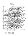
- FIG. 4 shows the situation-dependent routing for the transport and traffic management system according to the invention as a three-dimensional problem.
- the road network description SNB which is stored in digitized form in the xy plane in the traffic control computer, the time is superimposed as a third dimension:
- the "time levels" t1, t2, t3 ... correspond to the time intervals t1, t2, t3,. .. in Fig.3.
- the small “clocks” in Fig.4 symbolize the travel times for each route section S1, S2, S3, ... within the time intervals t1, t2, t3 .... These travel times are taken from the travel time curve (Fig.3).
- a route section S1, S2, S3, ... extends from a node K1, K2, K3, ... in the road network description SNB to the next.
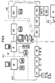
- the traffic control and information center is divided into the traffic control center of the police VLZP and the control and information center LIZ.
- the traffic control computer VLR as shown in FIGS. 1 and 2, consists of several computers which are connected to one another by a ring bus system.
- a control computer BR is in the traffic control center of the police VLZP.
- the guidance and information computer is formed by a supply computer VR, which is used for entering and updating the road network, a gangway computer GLR, which processes the travel and traffic jam times, and a plurality of route computers RR1 to RR3, which are used to calculate the optimal routes .
- the individual beacons are connected to these via nodes.
- the transport and traffic control system according to the invention is used for optimal route and destination guidance of delivery vehicles, ie trucks.
- delivery vehicles ie trucks.
- trucks are often to be led via other routes because, for example, certain roads are blocked for them.
- Vehicles with dangerous loads are also not allowed to use tunnel routes.
- bridges or underpasses for which there are weight, height, length or width restrictions for the vehicles.
- the road network is therefore prepared for the delivery vehicles.
- the travel times of the trucks are different from the travel times for cars. Therefore, in the control and information center LIZ there are more computers mentioned above Assigned computers that are connected to the other computers via a ring bus line.
- a chart computer TGLR for calculating the travel time of the delivery vehicles and three route computers TRR1 to TRR3 for calculating the delivery vehicle routes are combined as one computer, which is referred to as the transport route calculator TRR.
- This transport route computer TRR can be connected to the tour computers TR of the hauliers FU via a transmission device MODST, MOD. This is shown on the right in Fig. 5.
- the transmission device here consists of a modem control MODST and a dialing modem MOD, which connects the transport route computer TRR to the tour computer TR via the public telephone network ⁇ N or the data line DL1.
- FIG. 6 shows how the trip computer TR at the haulage contractor FU is supplemented with further facilities for the transport and traffic management system.
- a modem for the telephone dialing network MODFU is connected to the trip computer TR.
- loading beacons LHB are connected to the tour computer TR via a beacon connection device BAE and a beacon electronics BEFU, as has already been explained with reference to FIG.
Landscapes
- Engineering & Computer Science (AREA)
- Radar, Positioning & Navigation (AREA)
- Remote Sensing (AREA)
- Physics & Mathematics (AREA)
- General Physics & Mathematics (AREA)
- Traffic Control Systems (AREA)
- Control Of Position, Course, Altitude, Or Attitude Of Moving Bodies (AREA)
Claims (5)
- Système de guidage pour le transport et le trafic, comportant un ordinateur (TR) de commande des trajets qui sert à optimiser le programme des trajets (tournées de livraison) dans une entreprise de transport routier (FU), comportant des véhicules de livraison (LFZ), qui sont équipés d'un dispositif de guidage et de transmission d'informations (LIE), ainsi qu'un calculateur (VLR) de guidage du trafic d'une commune pour un système de guidage et de transmission d'informations (LIS) pour le trafic individuel, caractérisé par les particularités suivantes :a) au système de guidage et de transmission d'informations (LIS) est raccordé, dans le calculateur (VLR) de guidage du trafic, un calculateur (TRR) de détermination des trajets de transport, en aval duquel est branché un dispositif de transmission de données (MOD,MODST),b) les données du réseau et les données actuelles de trafic, qui peuvent être introduites dans le système de guidage et de transmission d'informations (LIS) sous la forme de descriptions numérisées (SNB) du réseau routier, sont traitées et préparées dans le calculateur (TRR) de détermination des trajets de transport,c) au moins un calculateur (TR) de commande des trajets, peut être raccordé par l'intermédiaire d'un dispositif de transmission (MODFU) au calculateur (TR1) de commande des trajets de transport,d) des données particulières de guidage et de transmission d'informations, qui sont transmises par le calculateur (TRR) de détermination des trajets de transport, au calculateur (TR) de commande des trajets, sont combinés, dans le calculateur (TR) de commande des trajets, aux données du programme des trajets et, à partir de là, des trajets optimum de déplacement avec le nom, l'adresse, les coordonnées et la séquence des clients à livrer (B) sont calculés pour chaque véhicule de livraison (LFZ),e) au calculateur (TR) de commande des trajets sont raccordés, par l'intermédiaire d'un dispositif de raccordement de balise (BAE) et d'un système électronique de balise (BEFU), une ou plusieurs balises d'une cour de chargement (LHB),f) le calculateur (TR) de commande des trajets transmet, au moyen des balises de la cour de chargement, les données respectives des trajets ainsi que des chaînes associées de vecteurs de guidage, aux véhicules de livraison (LFZa) qui sortent de la cour de chargement (B),g) dans les véhicules de livraison (LFZ), un pilotage de destination, qui dépend de la situation, jusqu'au client est indiqué au moyen du système connu de guidage et de transmission d'information (LIS) au dispositif d'affichage (ANZ) du dispositif de guidage et de transmission d'informations (LIE).
- Système de guidage pour le transport et le trafic suivant la revendication 1, caractérisé par le fait que dans le dispositif de guidage et de transmission d'informations (LIE) du véhicule de livraison (LFZ), les temps de déplacement jusque chez les différents clients (B) et les temps d'attente chez ces derniers sont mesurés et mémorisés au moyen de leur calculateur de repérage et de navigation (ONR) et de leur dispositif de mesure de temps de déplacement (RZM), et que le temps de déplacement et le temps d'attente sont transmis à l'adresse associée du client lors du retour (a) dans la cour de chargement (A), par l'intermédiaire de la balise (LHB) de la cour de chargement, par le calculateur de repérage et de navigation (ONR) au calculateur (TR) de commande des trajets et sont mémorisés pour le calcul des nouveaux trajets optimum de déplacement.
- Système de guidage pour le transport et le trafic suivant la revendication 2, caractérisé par le fait que la mesure du temps d'arrêt est déclenchée automatiquement dans le dispositif de mesure de temps de déplacement (RZM) et que le calculateur de repérage et de navigation situé dans le véhicule établit que la position du véhicule coïncide dans une large mesure avec les coordonnées du client à livrer et que le conducteur arrête le véhicule de livraison (LFZ), que la mesure du temps d'arrêt est interrompue et que la mesure du temps de déplacement est déclenchée dès que le véhicule de livraison (LFZ) a démarré et qu'une touche de démarrage prévue en propre à cet effet sur l'appareil de commande (BG) du dispositif de guidage et de transmission d'informations (LIE) est actionné, et que de ce fait, le pilotage ultérieur jusqu'au client immédiatement suivant est indiqué sur le dispositif d'affichage (ANZ).
- Système de guidage pour le transport et le trafic suivant l'une des revendications précédentes, caractérisé par le fait que le calculateur (TRR) de détermination des trajets de transport est formé par des calculateurs individuels de détermination de trajets (TRR1, TRR2 et TRR3) et par un calculateur (TGLR), qui détermine des allures de transport et dans lequel les temps prévisibles de déplacement (RZ) pour les véhicules de livraison (LFZ) sont déterminés et transmis au calculateur (TR) de commande des trajets.
- Système de guidage pour le transport et le trafic suivant l'une des revendications précédentes, caractérisé par le fait que chaque séquence des trajets est caractérisée par un chiffre caractéristique, au moyen duquel le véhicule de livraison (LFZ), qui a chargé le chargement pour ce client, appelle, par la balise (LHB) de la cour de chargement (A), lorsqu'il quitte cette cour, les noms, adresses et coordonnées des clients selon une succession qui a été calculée comme étant optimale par le calculateur (TR) de commande des trajets.
Priority Applications (1)
| Application Number | Priority Date | Filing Date | Title |
|---|---|---|---|
| AT88106427T ATE78357T1 (de) | 1987-04-24 | 1988-04-21 | Transport- und verkehrsleitsystem. |
Applications Claiming Priority (2)
| Application Number | Priority Date | Filing Date | Title |
|---|---|---|---|
| DE3713796 | 1987-04-24 | ||
| DE3713796 | 1987-04-24 |
Publications (2)
| Publication Number | Publication Date |
|---|---|
| EP0288068A1 EP0288068A1 (fr) | 1988-10-26 |
| EP0288068B1 true EP0288068B1 (fr) | 1992-07-15 |
Family
ID=6326246
Family Applications (1)
| Application Number | Title | Priority Date | Filing Date |
|---|---|---|---|
| EP88106427A Expired - Lifetime EP0288068B1 (fr) | 1987-04-24 | 1988-04-21 | Système de guidage pour le transport et le trafic |
Country Status (3)
| Country | Link |
|---|---|
| EP (1) | EP0288068B1 (fr) |
| AT (1) | ATE78357T1 (fr) |
| DE (1) | DE3872750D1 (fr) |
Cited By (27)
| Publication number | Priority date | Publication date | Assignee | Title |
|---|---|---|---|---|
| US8031050B2 (en) | 2000-06-07 | 2011-10-04 | Apple Inc. | System and method for situational location relevant invocable speed reference |
| US8060389B2 (en) | 2000-06-07 | 2011-11-15 | Apple Inc. | System and method for anonymous location based services |
| US8073565B2 (en) | 2000-06-07 | 2011-12-06 | Apple Inc. | System and method for alerting a first mobile data processing system nearby a second mobile data processing system |
| US8108144B2 (en) | 2007-06-28 | 2012-01-31 | Apple Inc. | Location based tracking |
| US8175802B2 (en) | 2007-06-28 | 2012-05-08 | Apple Inc. | Adaptive route guidance based on preferences |
| US8204684B2 (en) | 2007-06-28 | 2012-06-19 | Apple Inc. | Adaptive mobile device navigation |
| US8260320B2 (en) | 2008-11-13 | 2012-09-04 | Apple Inc. | Location specific content |
| US8275352B2 (en) | 2007-06-28 | 2012-09-25 | Apple Inc. | Location-based emergency information |
| US8290513B2 (en) | 2007-06-28 | 2012-10-16 | Apple Inc. | Location-based services |
| US8311526B2 (en) | 2007-06-28 | 2012-11-13 | Apple Inc. | Location-based categorical information services |
| US8332402B2 (en) | 2007-06-28 | 2012-12-11 | Apple Inc. | Location based media items |
| US8355862B2 (en) | 2008-01-06 | 2013-01-15 | Apple Inc. | Graphical user interface for presenting location information |
| US8359643B2 (en) | 2008-09-18 | 2013-01-22 | Apple Inc. | Group formation using anonymous broadcast information |
| US8369867B2 (en) | 2008-06-30 | 2013-02-05 | Apple Inc. | Location sharing |
| US8644843B2 (en) | 2008-05-16 | 2014-02-04 | Apple Inc. | Location determination |
| US8660530B2 (en) | 2009-05-01 | 2014-02-25 | Apple Inc. | Remotely receiving and communicating commands to a mobile device for execution by the mobile device |
| US8666367B2 (en) | 2009-05-01 | 2014-03-04 | Apple Inc. | Remotely locating and commanding a mobile device |
| US8670748B2 (en) | 2009-05-01 | 2014-03-11 | Apple Inc. | Remotely locating and commanding a mobile device |
| US8762056B2 (en) | 2007-06-28 | 2014-06-24 | Apple Inc. | Route reference |
| US8774825B2 (en) | 2007-06-28 | 2014-07-08 | Apple Inc. | Integration of map services with user applications in a mobile device |
| CN104240053A (zh) * | 2014-07-31 | 2014-12-24 | 东莞市福欣电脑科技有限公司 | 一种规划配送车辆行程的方法 |
| CN104318794A (zh) * | 2014-10-24 | 2015-01-28 | 浙江大学 | 一种基于考虑城市交叉口时间延误的实用路径选择方法 |
| US8977294B2 (en) | 2007-10-10 | 2015-03-10 | Apple Inc. | Securely locating a device |
| US9031581B1 (en) | 2005-04-04 | 2015-05-12 | X One, Inc. | Apparatus and method for obtaining content on a cellular wireless device based on proximity to other wireless devices |
| US9066199B2 (en) | 2007-06-28 | 2015-06-23 | Apple Inc. | Location-aware mobile device |
| US9109904B2 (en) | 2007-06-28 | 2015-08-18 | Apple Inc. | Integration of map services and user applications in a mobile device |
| US9250092B2 (en) | 2008-05-12 | 2016-02-02 | Apple Inc. | Map service with network-based query for search |
Families Citing this family (8)
| Publication number | Priority date | Publication date | Assignee | Title |
|---|---|---|---|---|
| DE4214067C2 (de) * | 1992-04-29 | 1995-08-31 | Heinrich Wanko | Verfahren zur Überwachung des Transports von Gütern zu vorbestimmten Abnahmestellen |
| JPH0886662A (ja) * | 1994-07-18 | 1996-04-02 | Sumitomo Electric Ind Ltd | 車載の走行経路表示装置、道路情報送信装置、経路案内システムおよびナビゲーションシステムの表示方法 |
| JP3045013B2 (ja) * | 1994-09-16 | 2000-05-22 | 住友電気工業株式会社 | ナビゲーション装置 |
| DE19519066A1 (de) * | 1994-11-28 | 1996-05-30 | Mannesmann Ag | Verfahren und System zur Zielführung eines Fahrzeugs |
| FR2791160B1 (fr) * | 1999-03-17 | 2001-09-14 | Bouchy Holding | Dispositif pour la gestion de l'activite d'une equipe de representants commerciaux itinerants, notamment d'une equipe de visiteurs medicaux |
| AU2003902042A0 (en) * | 2003-04-30 | 2003-05-15 | Nextspace Technologies Pty Ltd | Delivery and/or collection optimization system & method |
| US8385946B2 (en) | 2007-06-28 | 2013-02-26 | Apple Inc. | Disfavored route progressions or locations |
| CN112258131B (zh) * | 2020-11-12 | 2021-08-24 | 拉扎斯网络科技(上海)有限公司 | 路径预测网络训练、订单处理方法及装置 |
Family Cites Families (3)
| Publication number | Priority date | Publication date | Assignee | Title |
|---|---|---|---|---|
| DE2923634C2 (de) * | 1979-06-11 | 1985-01-17 | Siemens AG, 1000 Berlin und 8000 München | Leitsystem für den Individualverkehr |
| DE2936062C2 (de) * | 1979-09-06 | 1985-11-07 | Siemens AG, 1000 Berlin und 8000 München | Leitsystem für den Individualverkehr und Verfahren zur Übertragung von Leitinformationen |
| DE2945852A1 (de) * | 1979-11-13 | 1981-05-21 | Siemens AG, 1000 Berlin und 8000 München | Verfahren zur verkehrserfassung in einem leit- und informationssystem fuer den individualverkehr |
-
1988
- 1988-04-21 DE DE8888106427T patent/DE3872750D1/de not_active Expired - Lifetime
- 1988-04-21 AT AT88106427T patent/ATE78357T1/de not_active IP Right Cessation
- 1988-04-21 EP EP88106427A patent/EP0288068B1/fr not_active Expired - Lifetime
Cited By (70)
| Publication number | Priority date | Publication date | Assignee | Title |
|---|---|---|---|---|
| US8489669B2 (en) | 2000-06-07 | 2013-07-16 | Apple Inc. | Mobile data processing system moving interest radius |
| US8060389B2 (en) | 2000-06-07 | 2011-11-15 | Apple Inc. | System and method for anonymous location based services |
| US8073565B2 (en) | 2000-06-07 | 2011-12-06 | Apple Inc. | System and method for alerting a first mobile data processing system nearby a second mobile data processing system |
| US9100793B2 (en) | 2000-06-07 | 2015-08-04 | Apple Inc. | System and method for alerting a first mobile data processing system nearby a second mobile data processing system |
| US8031050B2 (en) | 2000-06-07 | 2011-10-04 | Apple Inc. | System and method for situational location relevant invocable speed reference |
| US8984059B2 (en) | 2000-06-07 | 2015-03-17 | Apple Inc. | Mobile data processing system moving interest radius |
| US9317867B2 (en) | 2000-06-07 | 2016-04-19 | Apple Inc. | System and method for situational location relevant invocable speed reference |
| US8963686B2 (en) | 2000-06-07 | 2015-02-24 | Apple Inc. | System and method for situational location relevant invocable speed reference |
| US8930233B2 (en) | 2000-06-07 | 2015-01-06 | Apple Inc. | System and method for anonymous location based services |
| US8538685B2 (en) | 2000-06-07 | 2013-09-17 | Apple Inc. | System and method for internet connected service providing heterogeneous mobile systems with situational location relevant content |
| US10341808B2 (en) | 2005-04-04 | 2019-07-02 | X One, Inc. | Location sharing for commercial and proprietary content applications |
| US9736618B1 (en) | 2005-04-04 | 2017-08-15 | X One, Inc. | Techniques for sharing relative position between mobile devices |
| US10200811B1 (en) | 2005-04-04 | 2019-02-05 | X One, Inc. | Map presentation on cellular device showing positions of multiple other wireless device users |
| US10165059B2 (en) | 2005-04-04 | 2018-12-25 | X One, Inc. | Methods, systems and apparatuses for the formation and tracking of location sharing groups |
| US10313826B2 (en) | 2005-04-04 | 2019-06-04 | X One, Inc. | Location sharing and map support in connection with services request |
| US9167558B2 (en) | 2005-04-04 | 2015-10-20 | X One, Inc. | Methods and systems for sharing position data between subscribers involving multiple wireless providers |
| US9967704B1 (en) | 2005-04-04 | 2018-05-08 | X One, Inc. | Location sharing group map management |
| US9955298B1 (en) | 2005-04-04 | 2018-04-24 | X One, Inc. | Methods, systems and apparatuses for the formation and tracking of location sharing groups |
| US9942705B1 (en) | 2005-04-04 | 2018-04-10 | X One, Inc. | Location sharing group for services provision |
| US9883360B1 (en) | 2005-04-04 | 2018-01-30 | X One, Inc. | Rendez vous management using mobile phones or other mobile devices |
| US9854402B1 (en) | 2005-04-04 | 2017-12-26 | X One, Inc. | Formation of wireless device location sharing group |
| US9854394B1 (en) | 2005-04-04 | 2017-12-26 | X One, Inc. | Ad hoc location sharing group between first and second cellular wireless devices |
| US9749790B1 (en) | 2005-04-04 | 2017-08-29 | X One, Inc. | Rendez vous management using mobile phones or other mobile devices |
| US10299071B2 (en) | 2005-04-04 | 2019-05-21 | X One, Inc. | Server-implemented methods and systems for sharing location amongst web-enabled cell phones |
| US9654921B1 (en) | 2005-04-04 | 2017-05-16 | X One, Inc. | Techniques for sharing position data between first and second devices |
| US9615204B1 (en) | 2005-04-04 | 2017-04-04 | X One, Inc. | Techniques for communication within closed groups of mobile devices |
| US9584960B1 (en) | 2005-04-04 | 2017-02-28 | X One, Inc. | Rendez vous management using mobile phones or other mobile devices |
| US10750310B2 (en) | 2005-04-04 | 2020-08-18 | X One, Inc. | Temporary location sharing group with event based termination |
| US9467832B2 (en) | 2005-04-04 | 2016-10-11 | X One, Inc. | Methods and systems for temporarily sharing position data between mobile-device users |
| US10750311B2 (en) | 2005-04-04 | 2020-08-18 | X One, Inc. | Application-based tracking and mapping function in connection with vehicle-based services provision |
| US10791414B2 (en) | 2005-04-04 | 2020-09-29 | X One, Inc. | Location sharing for commercial and proprietary content applications |
| US10856099B2 (en) | 2005-04-04 | 2020-12-01 | X One, Inc. | Application-based two-way tracking and mapping function with selected individuals |
| US9031581B1 (en) | 2005-04-04 | 2015-05-12 | X One, Inc. | Apparatus and method for obtaining content on a cellular wireless device based on proximity to other wireless devices |
| US11356799B2 (en) | 2005-04-04 | 2022-06-07 | X One, Inc. | Fleet location sharing application in association with services provision |
| US11778415B2 (en) | 2005-04-04 | 2023-10-03 | Xone, Inc. | Location sharing application in association with services provision |
| US9253616B1 (en) | 2005-04-04 | 2016-02-02 | X One, Inc. | Apparatus and method for obtaining content on a cellular wireless device based on proximity |
| US9185522B1 (en) | 2005-04-04 | 2015-11-10 | X One, Inc. | Apparatus and method to transmit content to a cellular wireless device based on proximity to other wireless devices |
| US9066199B2 (en) | 2007-06-28 | 2015-06-23 | Apple Inc. | Location-aware mobile device |
| US8332402B2 (en) | 2007-06-28 | 2012-12-11 | Apple Inc. | Location based media items |
| US9109904B2 (en) | 2007-06-28 | 2015-08-18 | Apple Inc. | Integration of map services and user applications in a mobile device |
| US8108144B2 (en) | 2007-06-28 | 2012-01-31 | Apple Inc. | Location based tracking |
| US9310206B2 (en) | 2007-06-28 | 2016-04-12 | Apple Inc. | Location based tracking |
| US8175802B2 (en) | 2007-06-28 | 2012-05-08 | Apple Inc. | Adaptive route guidance based on preferences |
| US9414198B2 (en) | 2007-06-28 | 2016-08-09 | Apple Inc. | Location-aware mobile device |
| US8204684B2 (en) | 2007-06-28 | 2012-06-19 | Apple Inc. | Adaptive mobile device navigation |
| US9578621B2 (en) | 2007-06-28 | 2017-02-21 | Apple Inc. | Location aware mobile device |
| US8924144B2 (en) | 2007-06-28 | 2014-12-30 | Apple Inc. | Location based tracking |
| US8275352B2 (en) | 2007-06-28 | 2012-09-25 | Apple Inc. | Location-based emergency information |
| US8774825B2 (en) | 2007-06-28 | 2014-07-08 | Apple Inc. | Integration of map services with user applications in a mobile device |
| US8762056B2 (en) | 2007-06-28 | 2014-06-24 | Apple Inc. | Route reference |
| US8738039B2 (en) | 2007-06-28 | 2014-05-27 | Apple Inc. | Location-based categorical information services |
| US8694026B2 (en) | 2007-06-28 | 2014-04-08 | Apple Inc. | Location based services |
| US8290513B2 (en) | 2007-06-28 | 2012-10-16 | Apple Inc. | Location-based services |
| US8311526B2 (en) | 2007-06-28 | 2012-11-13 | Apple Inc. | Location-based categorical information services |
| US9131342B2 (en) | 2007-06-28 | 2015-09-08 | Apple Inc. | Location-based categorical information services |
| US10064158B2 (en) | 2007-06-28 | 2018-08-28 | Apple Inc. | Location aware mobile device |
| US8548735B2 (en) | 2007-06-28 | 2013-10-01 | Apple Inc. | Location based tracking |
| US8977294B2 (en) | 2007-10-10 | 2015-03-10 | Apple Inc. | Securely locating a device |
| US8355862B2 (en) | 2008-01-06 | 2013-01-15 | Apple Inc. | Graphical user interface for presenting location information |
| US9250092B2 (en) | 2008-05-12 | 2016-02-02 | Apple Inc. | Map service with network-based query for search |
| US8644843B2 (en) | 2008-05-16 | 2014-02-04 | Apple Inc. | Location determination |
| US8369867B2 (en) | 2008-06-30 | 2013-02-05 | Apple Inc. | Location sharing |
| US8359643B2 (en) | 2008-09-18 | 2013-01-22 | Apple Inc. | Group formation using anonymous broadcast information |
| US8260320B2 (en) | 2008-11-13 | 2012-09-04 | Apple Inc. | Location specific content |
| US8670748B2 (en) | 2009-05-01 | 2014-03-11 | Apple Inc. | Remotely locating and commanding a mobile device |
| US9979776B2 (en) | 2009-05-01 | 2018-05-22 | Apple Inc. | Remotely locating and commanding a mobile device |
| US8666367B2 (en) | 2009-05-01 | 2014-03-04 | Apple Inc. | Remotely locating and commanding a mobile device |
| US8660530B2 (en) | 2009-05-01 | 2014-02-25 | Apple Inc. | Remotely receiving and communicating commands to a mobile device for execution by the mobile device |
| CN104240053A (zh) * | 2014-07-31 | 2014-12-24 | 东莞市福欣电脑科技有限公司 | 一种规划配送车辆行程的方法 |
| CN104318794A (zh) * | 2014-10-24 | 2015-01-28 | 浙江大学 | 一种基于考虑城市交叉口时间延误的实用路径选择方法 |
Also Published As
| Publication number | Publication date |
|---|---|
| DE3872750D1 (de) | 1992-08-20 |
| EP0288068A1 (fr) | 1988-10-26 |
| ATE78357T1 (de) | 1992-08-15 |
Similar Documents
| Publication | Publication Date | Title |
|---|---|---|
| EP0288068B1 (fr) | Système de guidage pour le transport et le trafic | |
| DE60010993T2 (de) | Routenführungsvorrichtung | |
| DE69427327T2 (de) | Bordnavigationsanlage für Fahrzeuge | |
| US6754580B1 (en) | System for guiding vehicles | |
| DE69505136T2 (de) | Transportsystem | |
| DE69720188T2 (de) | Routenauswahlsystem für wandernde personen | |
| EP1006503B1 (fr) | Acquisition de places de parking | |
| EP0752692B1 (fr) | Procédé et système de mise à jour de cartes digitales routières | |
| DE60020065T2 (de) | Papierfreies betriebsdatenerfassungssystem und verfahren | |
| DE10013675B4 (de) | Fahrzeug-Navigationssystem | |
| DE69404989T2 (de) | Fahrzeugortungsanlage | |
| EP0021060B1 (fr) | Système de guidage pour la circulation individuelle | |
| DE19539641C2 (de) | Verfahren und Einrichtung zur verkehrssituationsabhängigen Fahrzeugzielführung | |
| EP0944893B2 (fr) | Procede de selection d'informations sur la circulation transmises par un central et concernant un trajet d'un vehicule equipe d'un terminal dans un reseau routier | |
| EP0567992B1 (fr) | Méthode de surveillance du transport de biens vers des lieux de déchargement prédéterminés | |
| DE4227969C2 (de) | Verfahren zur Nutzung eines Personenkraftfahrzeuges | |
| DE2829577A1 (de) | Verfahren und einrichtung zur ortung flaechengebundener fahrzeuge | |
| EP0944894B2 (fr) | Procede de navigation assistee par ordinateur d'un vehicule equipe d'un terminal, terminal et central d'informations routieres | |
| EP1512128A1 (fr) | Systeme de navigation pour vehicule | |
| DE19647461A1 (de) | Einrichtung und Verfahren für ein Fahrzeugortungs-, Auswerte- und Informationssystem | |
| EP0715289B1 (fr) | Procédé et système pour le guidage d'un véhicule | |
| AT411941B (de) | Verfahren zum erfassen von mindestens einem fahrzeug bzw. verkehrsteilnehmer auf öffentlichen verkehrsflächen | |
| DE19626114A1 (de) | Verfahren, fahrzeugseitige und stationäre Einrichtung zur individuellen Warnung vor Verkehrsstörungen | |
| DE102006017845A1 (de) | System und Verfahren zur Parkbuchtreservierung für LKWs | |
| WO2018171991A1 (fr) | Procédé de télécommande de plusieurs systèmes automoteurs sans pilotes et poste de contrôle de télécommande des systèmes automoteurs et système |
Legal Events
| Date | Code | Title | Description |
|---|---|---|---|
| PUAI | Public reference made under article 153(3) epc to a published international application that has entered the european phase |
Free format text: ORIGINAL CODE: 0009012 |
|
| AK | Designated contracting states |
Kind code of ref document: A1 Designated state(s): AT CH DE FR GB IT LI NL |
|
| 17P | Request for examination filed |
Effective date: 19890109 |
|
| 17Q | First examination report despatched |
Effective date: 19910829 |
|
| GRAA | (expected) grant |
Free format text: ORIGINAL CODE: 0009210 |
|
| AK | Designated contracting states |
Kind code of ref document: B1 Designated state(s): AT CH DE FR GB IT LI NL |
|
| REF | Corresponds to: |
Ref document number: 78357 Country of ref document: AT Date of ref document: 19920815 Kind code of ref document: T |
|
| REF | Corresponds to: |
Ref document number: 3872750 Country of ref document: DE Date of ref document: 19920820 |
|
| ET | Fr: translation filed | ||
| ITF | It: translation for a ep patent filed | ||
| GBT | Gb: translation of ep patent filed (gb section 77(6)(a)/1977) | ||
| PLBE | No opposition filed within time limit |
Free format text: ORIGINAL CODE: 0009261 |
|
| STAA | Information on the status of an ep patent application or granted ep patent |
Free format text: STATUS: NO OPPOSITION FILED WITHIN TIME LIMIT |
|
| 26N | No opposition filed | ||
| PGFP | Annual fee paid to national office [announced via postgrant information from national office to epo] |
Ref country code: CH Payment date: 19960724 Year of fee payment: 9 |
|
| PGFP | Annual fee paid to national office [announced via postgrant information from national office to epo] |
Ref country code: AT Payment date: 19970326 Year of fee payment: 10 |
|
| PG25 | Lapsed in a contracting state [announced via postgrant information from national office to epo] |
Ref country code: LI Free format text: LAPSE BECAUSE OF NON-PAYMENT OF DUE FEES Effective date: 19970430 Ref country code: CH Free format text: LAPSE BECAUSE OF NON-PAYMENT OF DUE FEES Effective date: 19970430 |
|
| REG | Reference to a national code |
Ref country code: CH Ref legal event code: PL |
|
| PG25 | Lapsed in a contracting state [announced via postgrant information from national office to epo] |
Ref country code: AT Free format text: LAPSE BECAUSE OF NON-PAYMENT OF DUE FEES Effective date: 19980421 |
|
| PGFP | Annual fee paid to national office [announced via postgrant information from national office to epo] |
Ref country code: GB Payment date: 20010409 Year of fee payment: 14 |
|
| PGFP | Annual fee paid to national office [announced via postgrant information from national office to epo] |
Ref country code: NL Payment date: 20010412 Year of fee payment: 14 |
|
| PGFP | Annual fee paid to national office [announced via postgrant information from national office to epo] |
Ref country code: FR Payment date: 20010420 Year of fee payment: 14 |
|
| PGFP | Annual fee paid to national office [announced via postgrant information from national office to epo] |
Ref country code: DE Payment date: 20010620 Year of fee payment: 14 |
|
| REG | Reference to a national code |
Ref country code: GB Ref legal event code: IF02 |
|
| PG25 | Lapsed in a contracting state [announced via postgrant information from national office to epo] |
Ref country code: GB Free format text: LAPSE BECAUSE OF NON-PAYMENT OF DUE FEES Effective date: 20020421 |
|
| PG25 | Lapsed in a contracting state [announced via postgrant information from national office to epo] |
Ref country code: NL Free format text: LAPSE BECAUSE OF NON-PAYMENT OF DUE FEES Effective date: 20021101 Ref country code: DE Free format text: LAPSE BECAUSE OF NON-PAYMENT OF DUE FEES Effective date: 20021101 |
|
| GBPC | Gb: european patent ceased through non-payment of renewal fee |
Effective date: 20020421 |
|
| PG25 | Lapsed in a contracting state [announced via postgrant information from national office to epo] |
Ref country code: FR Free format text: LAPSE BECAUSE OF NON-PAYMENT OF DUE FEES Effective date: 20021231 |
|
| NLV4 | Nl: lapsed or anulled due to non-payment of the annual fee |
Effective date: 20021101 |
|
| REG | Reference to a national code |
Ref country code: FR Ref legal event code: ST |
|
| PG25 | Lapsed in a contracting state [announced via postgrant information from national office to epo] |
Ref country code: IT Free format text: LAPSE BECAUSE OF NON-PAYMENT OF DUE FEES Effective date: 20050421 |