EP0351472A2 - Methode zur Korrektur des Distanzfehlers in einem Navigationssystem - Google Patents
Methode zur Korrektur des Distanzfehlers in einem Navigationssystem Download PDFInfo
- Publication number
- EP0351472A2 EP0351472A2 EP88312448A EP88312448A EP0351472A2 EP 0351472 A2 EP0351472 A2 EP 0351472A2 EP 88312448 A EP88312448 A EP 88312448A EP 88312448 A EP88312448 A EP 88312448A EP 0351472 A2 EP0351472 A2 EP 0351472A2
- Authority
- EP
- European Patent Office
- Prior art keywords
- intersection
- distance
- data
- distance error
- road
- Prior art date
- Legal status (The legal status is an assumption and is not a legal conclusion. Google has not performed a legal analysis and makes no representation as to the accuracy of the status listed.)
- Ceased
Links
- 238000000034 method Methods 0.000 title claims description 30
- 238000005286 illumination Methods 0.000 abstract description 2
- 238000010586 diagram Methods 0.000 description 5
- 238000006243 chemical reaction Methods 0.000 description 2
- 238000010276 construction Methods 0.000 description 2
- 238000001514 detection method Methods 0.000 description 2
- 230000005389 magnetism Effects 0.000 description 2
- 230000001133 acceleration Effects 0.000 description 1
- 238000013459 approach Methods 0.000 description 1
- 230000002950 deficient Effects 0.000 description 1
- 230000000694 effects Effects 0.000 description 1
- 230000005415 magnetization Effects 0.000 description 1
- 230000003287 optical effect Effects 0.000 description 1
Images




Classifications
-
- G—PHYSICS
- G01—MEASURING; TESTING
- G01C—MEASURING DISTANCES, LEVELS OR BEARINGS; SURVEYING; NAVIGATION; GYROSCOPIC INSTRUMENTS; PHOTOGRAMMETRY OR VIDEOGRAMMETRY
- G01C21/00—Navigation; Navigational instruments not provided for in groups G01C1/00 - G01C19/00
- G01C21/26—Navigation; Navigational instruments not provided for in groups G01C1/00 - G01C19/00 specially adapted for navigation in a road network
- G01C21/28—Navigation; Navigational instruments not provided for in groups G01C1/00 - G01C19/00 specially adapted for navigation in a road network with correlation of data from several navigational instruments
Definitions
- This invention relates to a method of correcting a distance error such as discordance between the present position and the point indicated on a map to represent the present position in a system for performing navigation along a predetermined course.
- a method of computing the present position during the operation of a vehiclenavigation system which makes use of a distance sensor for detecting the distance through which the vehicle has traveled, an orientation sensor such as an earth magnetism sensor or gyroscope for detecting the direction of traveling of the vehicle and a map memory unit having a video disk, video tape, CD-ROM or the like.
- a distance sensor for detecting the distance through which the vehicle has traveled
- an orientation sensor such as an earth magnetism sensor or gyroscope for detecting the direction of traveling of the vehicle
- a map memory unit having a video disk, video tape, CD-ROM or the like.
- the accuracy with which the present position is detected is not sufficient because there is a possibility of occurrence of an error in the detection of orientation if the the earth sensor is used to detect earth magnetism in a particular area where the degree of magnetic disturbance is high, for example, a place near a railroad crossing, a railroad or a power cable. Also, such an error may be caused by magnetization of the vehicle body.
- the above system is also defective in that the cost of the gyroscope is high and that the method of correcting the present position on the basis of comparison between the calculated positional value and the map data requires a large quantity of data, resulting in an increase in the time taken for computation.
- the present invention provides a distance error correction method for a system for performing navigation along a predetermined route having a distance sensor for detecting the present position, a route searching section for searching routes on the basis of the present position, intersection data, road data and node data, and a comparison/determination section for determining whether or not the remaining distance between the present position and a named intersection or a specific object of a route selected by searching is zero, the method including resetting the present position to correct distance error on the basis of data on the positions of nodes when the vehicle enters the distance error correction range of the named intersection or specific object and and passes therethrough.
- the navigation system has a distance sensor 1, a steeling angle sensor 3, a present point/destination input section 5, a navigation processing section 7, a curve detecting section 9, a comparison/determination section 11, a route searching section 13, a guidance processing section 15, a steeling angle-traveling direction conversion table 17, an intersection data file 19, a node series data file 21, a road data file 23, a searched route data file, a photographic data file 27, a map data file 19, a display section 31, and a speech output section 33.
- the distance sensor 1 is adapted to measure the distance through which the vehicle has traveled.
- the distance sensor 1 may be a means for detecting the number of revolutions of a wheel, a means for detecting the acceleration and integrating a detected value two times, or other measuring means.
- the steering angle sensor 3 which detects whether or not the vehicle has turned a corner may be constituted by an optical rotary sensor, a rotary variable resistor or the like attached to, for example, a rotary member of the steering wheel or may be an angle sensor attached to the steering system.
- the present point/destination input section 5 is constituted by a joy stick, a key cluster or a touch panel and is used, in combination with the screen of the display section 31, to show keys and a menu on the screen and enable input through the screen.
- the navigation processing section 7 is the center of the navigation system, and has the curve detecting section 9, the comparison / determination section 11, the route searching section and the guidance processing section 15.
- the route searching section 13 reads out later- described intersection data, node data and road data from the corresponding files to perform routesearching when supplied with a present point and a destination point from the input section 5.
- the route searching section 13 thereafter stores searched routes in the file 25.
- the curve detecting section 9 reads detection . outputs from the distance sensor 1 and the steeling angle sensor 3 and detects a change in the vehicle orientation by referring to the steering angle-traveling direction conversion table 17.
- the comparison/determination section 11 compares an angle detected by the curve detecting section 9 with an intersection angle or node angle of a route identified by searching while the vehicle travels near a guidance intersection of between guidance intersections on the course. If the difference between these angles is not larger than a predetermined value, the comparison/determination section 11 determines that the vehicle has correctly turned at the intersection or node.
- the guidance processing section effects distance correction on the basis of the intersection data or node data to calculate the present position when the comparison/determination section 11 has determined that the vehicle has correctly turned or when a correction command is issued from the route searching section 13 at a particular point, e.g., an intersection.
- the present position is calculated as the distance from the intersection passed at the preceding time.
- the guidance processing section 15 displays the present position or outputs as a speech if necessary. Also, the guidance processing section 15 successively displays photographs showing intersections of the selected route and landmarks or the like located at intermediate points on the course, as well as the distance remaining until the next intersection is reached and other items of guidance information, while making the speech output section 25 output speech guidance. If any deviation from the course is detected, the guidance processing section 15 makes a display indicating deviation from the course while outputting a corresponding speech to inform the driver of this state.
- intersection data, node data and road data used for route searching will be described below.
- intersection data includes items of information on roads crossing at intersections
- the node data includes items of information on specific points on the course such as pedestrian crossings and tunnels
- the road data includes items of information on roads with respect to starting and terminal ends thereof and so forth.
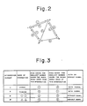
- Figs. 2 to 5 are diagrams or tables showing examples of the road system, the intersection data, road data and the node series data.
- intersection data items such as those shown in Fig. 3; road data items such as those shown in Fig. 4; and node data items such as those shown in Fig. 5 are used to detect at all times the distance between the present position of the vehicle and the destination with accuracy.
- intersection data is constituted by, in correspondence with intersection numbers I to IV, intersection names, numbers each of which is the smallest of road numbers designating roads starting from one of the intersections I to IV, numbers each of which is the smallest of road numbers designating roads terminating at one of intersections I to IV, and values each representing existence or absence of traffic signals.
- the road data is constituted by, in correspondence with road numbers
- the node data is constituted by east longitudes, north latitudes and attributes, as shown in Fig. 5.
- the unit road indicated by each road number is defined by a plurality of nodes. That is, the node data relates to -points on the roads. If something connecting a pair of nodes is called an arc, a road can be expressed by connecting, with an arc, each of adjacent pairs of nodes constituting a series of a plurality of nodes. For example, with respect to road number 0 11, the number of nodes is 15 and the top address of the corresponding node data items is 100. The road number 0 11 therefore designates a series of fifteen nodes represented by node data items with addresses 100 to 114.
- a road number 0 11 is first found from starting point information of the intersection data, and road number
- Fig. 5 shows examples of items of data prepared by route searching: intersection series data (a); and node series data (b).
- the intersection series data is constituted by various items including intersection names, intersection numbers, photograph numbers indicating photographs of specific views of intersections, turning angles and distances.
- the node series data is constituted by east longitudes and north latitudes representing the positions of nodes, intersection numbers, attributes, angles and distances. These items of data are provided only for intersections where guidance is needed except for guidance-free intersections. During navigation, therefore, it is sufficient to read out and output these items of data in correspondence with the predetermined positions.
- the vehicle is tracked with accuracy during traveling and the present position of the vehicle is ascertained with accuracy at all times on the basis of the intersection data, road data and node series data.
- Figs. 7 and 8 show an example of guidance route displayed on the screen by the display section 31.
- Fig. 7 shows symbols or illustrations relating to straight-ahead travel from a guidance intersection A to another guidance intersection B.
- the next named intersection B is displayed while the remaining distance to another named intersection C is displayed in an indicator 32.
- this window is closed and another window in which the remaining distance, the direction into which the vehicle is turned, a view of the inter section are displayed is then opened.
- Reference characters C and D designate named intersections, and a reference character E designates the present position displayed.
- a signal can be input in a touch-panel input manner through the portion of the display screen where the named intersection C is displayed.
- color of the display portion of the next named intersection C changes to, for example, red, and distance correction is performed if this portion is touched when the vehicle passes through the intersection.
- step 51 the present point tracking routine is called in step 51 to track the present position and display the position of the vehicle on the display screen.
- step 52 whether or not the vehicle is traveling on the course is determined. If it is determined that the vehicle has deviated from the course, whether or not the series of guidance nodes has been cleared is determined in step 54. If NO, the process jumps to step 57. If YES, a present position guidance route array number RGP (Fig. 13) is updated in step 55. Then, in step 56, a node series preparation routine is called. In step 57, whether or not a distance error range flag FLIMIT is 0 or whether or not the vehicle position is within the distance error correction range is determined.
- step 60 whether or not the vehicle has arrived is determined in step 60. If NO, the above process is repeated or, if YES, a desired succeeding process is started.
- Fig. 10 shows the guidance route node series preparation routine of step 56.
- step 61 of this routine whether or not the position of a designated node has been read to the node series information array is determined. If YES, node series information on the side of starting point relative to the designated point is deleted in step 62. Then, in step 63, the distance between the designated position and a terminal point node which has already been read is obtained.
- step 64 node series information is set by being read from the road data file and the intersection data file until a point beyond the terminal point node (designated node terminal-side distance - D). If NO in step 61, the position of node at the predetermined distance from the designated node on the side of the starting point is detected in step 65. In step 66, node series information from node position to (starting- point-side distance to terminal-point side distance) is set by being called form the road data file and the intersection data file.
- Fig. 11 shows the flow chart of the distance correction of step 59 shown in Fig. 9.
- a drawn guidance route array number Pg is smaller than the present position guidance route array number RGP or whether or not a name drawing completion flag f "xt is 0 is determined. In other words, determination is made as to whether or not the name of the next intersection on the road passed at the present time has previously been drawn with respect to the corresponding road number.
- step 105 whether or not the terminal point of the road indicated by the road number corresponding to Pg corresponds to the next guidance intersection (Fig. 8B) is determined. In NO, a touch panel input permission flag FTOUCH is set to 0 and the process returns. If YES, whether or not there is any intersection name for the terminal point of the road corresponding to Pg is determined in step 106. If there is no intersection name. Pg is incremented in step 110 and the above processing is repeated. If an intersection name is found in step 106, the name of the intersection (Fig.
- step 107 the name drawing completion flag f nxt t is set to 1
- an intersection name color change drawing completion flag fred is set to 0
- the touch panel input permission flag FTOUCH is set to 0. The process then returns.
- step 103 whether or not Pg and RGP are equal to each other, that is, whether or not the road for which the intersection name has been drawn is traveled is determined in step 111. Determination is also made as to whether or not the intersection error range flag FLIMIT is 1 and whether or not the intersection name color change drawing completion flag fred is 0. If YES, the name of the intersection (Fig. 7C) of the road indicated by Pg is drawn with a different color or with on-and-off illumination in step 112. In step 113, the name drawing completion flag f nx; is set to 0, the intersection name color change drawing completion flag fred is set to 1, and the touch panel input permission flag FTOUCH is set to 0. The process then returns.
- step 111 whether or not the touch panel input permission flag FTOUCH is set to 1 is determined in step 114. If NO, the process returns. If YES, whether or not the remaining guidance route node distance is 0 is determined in step 115. If the distance is 0, an intersection passage sound is output in step 116, and whether or not the driver has effected touch panel input at the intersection is determined in step 117. If No, the process returns. If YES, the present position correction routine of step 118 is called, the touch panel input permission flag FTOUCH is set to 0, and the process returns.
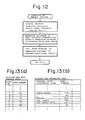
- Fig. 12 shows the present position correction routine of step 118 in the previous figure.
- Fig. 13(a) shows a guidance node road number array file prepared in the processing shown in Fig. 10 and shows the relationship between the array numbers and road numbers assigned to Pg and RGP during traveling along the guidance route.
- Fig. 13(b) shows a guidance node information array file in which data on terminal intersection names and data on node intervals are stored.
- Fig. 14 shows changes in the array numbers Pg and RGP, the name drawing completion flag f nxt , the intersection name color change drawing completion flag fred and the touch panel input permission flag FTOUCH. Numbers with circles and intersection names on the guidance route correspond to the road numbers and intersection names shown in Fig. 13.
- step 104 RGP is set to 9, and "Gyorin" is drawn.
- f nxt is set to I, fred to 0, and FTOUCH to 0.
- FLIMIT 1 is established and the process proceeds from steps 112 and 113, thereby setting f n xt to 0, fred to 1, and FTOUCH to 1.
- RGP is set to 10 by being updated by the processing of Fig. 10, and Pg is also set to 10 in step 104 by the determination of step 103.
- the present invention is not limited to the above-described embodiment and it can be modified in various ways.
- the error correction range is set within 10 % of the distance between a previously passed intersection and the next named intersection. Instead, the error correction range may be set within a predetermined distance from each named intersection. Distance correction is performed at each intersection in the described embodiment, but it can also be performed on the basis of the position of a specific object such as a river, a railroad or a building as long as the position thereof can be ascertained.
Landscapes
- Engineering & Computer Science (AREA)
- Radar, Positioning & Navigation (AREA)
- Remote Sensing (AREA)
- Automation & Control Theory (AREA)
- Physics & Mathematics (AREA)
- General Physics & Mathematics (AREA)
- Navigation (AREA)
- Traffic Control Systems (AREA)
Applications Claiming Priority (2)
| Application Number | Priority Date | Filing Date | Title |
|---|---|---|---|
| JP63178427A JPH0227218A (ja) | 1988-07-18 | 1988-07-18 | ナビゲーション装置における距離誤差修正方法 |
| JP178427/88 | 1988-07-18 |
Publications (2)
| Publication Number | Publication Date |
|---|---|
| EP0351472A2 true EP0351472A2 (de) | 1990-01-24 |
| EP0351472A3 EP0351472A3 (de) | 1991-09-25 |
Family
ID=16048318
Family Applications (1)
| Application Number | Title | Priority Date | Filing Date |
|---|---|---|---|
| EP19880312448 Ceased EP0351472A3 (de) | 1988-07-18 | 1988-12-30 | Methode zur Korrektur des Distanzfehlers in einem Navigationssystem |
Country Status (3)
| Country | Link |
|---|---|
| US (1) | US4937752A (de) |
| EP (1) | EP0351472A3 (de) |
| JP (1) | JPH0227218A (de) |
Cited By (1)
| Publication number | Priority date | Publication date | Assignee | Title |
|---|---|---|---|---|
| EP0456595A3 (en) * | 1990-04-10 | 1992-03-25 | Panagiotis A. Anagnostopoulos | Method for guiding vehicle drivers to a predetermined target |
Families Citing this family (35)
| Publication number | Priority date | Publication date | Assignee | Title |
|---|---|---|---|---|
| DE69126630T2 (de) * | 1990-03-06 | 1998-01-29 | Pioneer Electronic Corp | Navigationsgerät für Fahrzeuge |
| US5323321A (en) * | 1990-06-25 | 1994-06-21 | Motorola, Inc. | Land vehicle navigation apparatus |
| US5243528A (en) * | 1990-09-12 | 1993-09-07 | Motorola, Inc. | Land vehicle navigation apparatus with visual display |
| JP3155022B2 (ja) * | 1991-04-23 | 2001-04-09 | パイオニア株式会社 | 車載ナビゲーション装置 |
| JP3295892B2 (ja) * | 1991-06-13 | 2002-06-24 | 三菱電機株式会社 | 交通情報提示装置 |
| JP3305341B2 (ja) * | 1991-09-27 | 2002-07-22 | パイオニア株式会社 | ナビゲーション装置 |
| JP2554567B2 (ja) * | 1991-10-02 | 1996-11-13 | スタンレー電気株式会社 | 道路情報の表示方法 |
| WO1993009509A1 (en) * | 1991-11-01 | 1993-05-13 | Motorola, Inc. | An improved accuracy sensory system for vehicle navigation |
| US8352400B2 (en) | 1991-12-23 | 2013-01-08 | Hoffberg Steven M | Adaptive pattern recognition based controller apparatus and method and human-factored interface therefore |
| US10361802B1 (en) | 1999-02-01 | 2019-07-23 | Blanding Hovenweep, Llc | Adaptive pattern recognition based control system and method |
| JP2973695B2 (ja) * | 1992-03-12 | 1999-11-08 | 船井電機株式会社 | 車載用ナビゲーションシステム |
| JP2760253B2 (ja) * | 1992-07-14 | 1998-05-28 | 住友電気工業株式会社 | 道路の動画像作成方法及びこの方法を適用した車載ナビゲーション装置 |
| EP0580105B1 (de) * | 1992-07-20 | 1999-02-03 | Toyota Jidosha Kabushiki Kaisha | Navigationsgerät für Fahrzeuge mit Erkennung von Kurven und Leitung der Fahrzeuge mittels Sprache |
| EP0588086B1 (de) * | 1992-08-19 | 1998-06-17 | Aisin Aw Co., Ltd. | Navigationssystem mittels Sprache |
| JP3221746B2 (ja) * | 1992-10-14 | 2001-10-22 | パイオニア株式会社 | ナビゲーション装置 |
| JP3223220B2 (ja) * | 1993-10-28 | 2001-10-29 | 本田技研工業株式会社 | 車両の相互通信装置 |
| US5682525A (en) | 1995-01-11 | 1997-10-28 | Civix Corporation | System and methods for remotely accessing a selected group of items of interest from a database |
| JP3578511B2 (ja) * | 1995-04-21 | 2004-10-20 | 株式会社ザナヴィ・インフォマティクス | 現在位置算出装置 |
| US5729109A (en) * | 1995-07-19 | 1998-03-17 | Matsushita Electric Industrial Co., Ltd. | Navigation system and intersection guidance method |
| KR970002797A (ko) * | 1995-11-30 | 1997-01-28 | 모리 하루오 | 네비게이션(navigation) 장치 |
| EP0916927B1 (de) * | 1997-05-15 | 2008-02-27 | Mitsubishi Denki Kabushiki Kaisha | Navigator |
| US7268700B1 (en) | 1998-01-27 | 2007-09-11 | Hoffberg Steven M | Mobile communication device |
| US6184823B1 (en) | 1998-05-01 | 2001-02-06 | Navigation Technologies Corp. | Geographic database architecture for representation of named intersections and complex intersections and methods for formation thereof and use in a navigation application program |
| US7966078B2 (en) | 1999-02-01 | 2011-06-21 | Steven Hoffberg | Network media appliance system and method |
| US7865306B2 (en) | 2000-09-28 | 2011-01-04 | Michael Mays | Devices, methods, and systems for managing route-related information |
| US6351710B1 (en) * | 2000-09-28 | 2002-02-26 | Michael F. Mays | Method and system for visual addressing |
| US6522958B1 (en) | 2000-10-06 | 2003-02-18 | Honeywell International Inc. | Logic method and apparatus for textually displaying an original flight plan and a modified flight plan simultaneously |
| US6922631B1 (en) | 2000-10-06 | 2005-07-26 | Honeywell International Inc. | System and method for textually displaying an original flight plan and a modified flight plan simultaneously |
| US9818136B1 (en) | 2003-02-05 | 2017-11-14 | Steven M. Hoffberg | System and method for determining contingent relevance |
| US8346465B2 (en) | 2008-02-26 | 2013-01-01 | Apline Electronics, Inc | Method and apparatus for determining and displaying meaningful cross street for navigation system |
| US20090216431A1 (en) | 2008-02-26 | 2009-08-27 | Tien Vu | Method and apparatus for adjusting distance for generating maneuver instruction for navigation system |
| US20100235078A1 (en) * | 2009-03-12 | 2010-09-16 | Microsoft Corporation | Driving directions with maps and videos |
| US20110099507A1 (en) * | 2009-10-28 | 2011-04-28 | Google Inc. | Displaying a collection of interactive elements that trigger actions directed to an item |
| US8618952B2 (en) * | 2011-01-21 | 2013-12-31 | Honda Motor Co., Ltd. | Method of intersection identification for collision warning system |
| JP7769521B2 (ja) * | 2021-11-16 | 2025-11-13 | 株式会社Subaru | 自車両位置情報取得装置、自車両位置情報取得システムおよび自車両位置情報取得方法 |
Family Cites Families (9)
| Publication number | Priority date | Publication date | Assignee | Title |
|---|---|---|---|---|
| JPS59157798A (ja) * | 1983-02-24 | 1984-09-07 | 株式会社デンソー | 車両用走行案内装置 |
| DE3323704A1 (de) * | 1983-07-01 | 1985-01-10 | Battelle-Institut E.V., 6000 Frankfurt | Informationssystem mit grafischer ausgabe |
| JPS60229799A (ja) * | 1984-04-27 | 1985-11-15 | 三菱電機株式会社 | 車載用ナビゲ−タ |
| JPH0644184B2 (ja) * | 1985-03-11 | 1994-06-08 | 日産自動車株式会社 | 車両用経路誘導装置 |
| JPS61209316A (ja) * | 1985-03-14 | 1986-09-17 | Nissan Motor Co Ltd | 車両用経路誘導装置 |
| JPS61216098A (ja) * | 1985-03-20 | 1986-09-25 | 日産自動車株式会社 | 車両用経路誘導装置 |
| DE3519277A1 (de) * | 1985-05-30 | 1986-12-04 | Robert Bosch Gmbh, 7000 Stuttgart | Navigationsverfahren fuer fahrzeuge |
| JP2526876B2 (ja) * | 1986-11-17 | 1996-08-21 | 日本電装株式会社 | 車両走行位置表示装置 |
| JPH01214711A (ja) * | 1988-02-23 | 1989-08-29 | Toshiba Corp | ナビゲーション装置 |
-
1988
- 1988-07-18 JP JP63178427A patent/JPH0227218A/ja active Pending
- 1988-12-27 US US07/290,136 patent/US4937752A/en not_active Expired - Fee Related
- 1988-12-30 EP EP19880312448 patent/EP0351472A3/de not_active Ceased
Cited By (2)
| Publication number | Priority date | Publication date | Assignee | Title |
|---|---|---|---|---|
| EP0456595A3 (en) * | 1990-04-10 | 1992-03-25 | Panagiotis A. Anagnostopoulos | Method for guiding vehicle drivers to a predetermined target |
| GR900100277A (en) * | 1990-04-10 | 1992-07-30 | Panagiotis Anagnostopoulos | Method for guiding drivers to a certain direction |
Also Published As
| Publication number | Publication date |
|---|---|
| EP0351472A3 (de) | 1991-09-25 |
| US4937752A (en) | 1990-06-26 |
| JPH0227218A (ja) | 1990-01-30 |
Similar Documents
| Publication | Publication Date | Title |
|---|---|---|
| US4937752A (en) | An apparatus for correcting distance error in a navigation system | |
| US7734415B2 (en) | Navigation system | |
| US5043902A (en) | Vehicular navigation apparatus | |
| US6453235B1 (en) | Vehicle navigation apparatus providing proper guidance for off-road net conditions | |
| US5067082A (en) | Navigation apparatus | |
| US4937751A (en) | Navigation apparatus | |
| US5852791A (en) | Vehicle navigation with vehicle position correction feature | |
| JP2526876B2 (ja) | 車両走行位置表示装置 | |
| CN100449267C (zh) | 车辆导航系统 | |
| US7539574B2 (en) | Vehicular navigation system | |
| EP0566390A1 (de) | Vorrichtung zur Bestimmung der Position eines Fahrzeuges | |
| JPH10246642A (ja) | 方位検出センサを使用して角速度補正を行うナビゲーション方法 | |
| US7346450B2 (en) | Vehicle navigation apparatus for controlling map-matching areas | |
| EP0355232A2 (de) | Strassenwiedergabesystem für Navigationsapparat | |
| JP3129846B2 (ja) | 車両用ナビゲーション装置 | |
| JP3757104B2 (ja) | ナビゲーション装置 | |
| JP3395929B2 (ja) | ナビゲーション装置 | |
| JP3262316B2 (ja) | 車両用ナビゲーション装置 | |
| JP3082293B2 (ja) | ナビゲーション装置 | |
| JP3509211B2 (ja) | 地図表示装置 | |
| JPH08304101A (ja) | ナビゲーション装置 | |
| JP2692822B2 (ja) | 車両用ナビゲーション装置 | |
| JP2783922B2 (ja) | 車両位置修正方法 | |
| JPH07113652A (ja) | 走行経路案内装置 | |
| EP0375816B1 (de) | Navigationseinrichtung |
Legal Events
| Date | Code | Title | Description |
|---|---|---|---|
| PUAI | Public reference made under article 153(3) epc to a published international application that has entered the european phase |
Free format text: ORIGINAL CODE: 0009012 |
|
| AK | Designated contracting states |
Kind code of ref document: A2 Designated state(s): DE FR GB |
|
| PUAL | Search report despatched |
Free format text: ORIGINAL CODE: 0009013 |
|
| AK | Designated contracting states |
Kind code of ref document: A3 Designated state(s): DE FR GB |
|
| 17P | Request for examination filed |
Effective date: 19920318 |
|
| 17Q | First examination report despatched |
Effective date: 19920619 |
|
| STAA | Information on the status of an ep patent application or granted ep patent |
Free format text: STATUS: THE APPLICATION HAS BEEN REFUSED |
|
| 18R | Application refused |
Effective date: 19940929 |