EP0433287B1 - Systeme de reperage et de navigation assiste par plan geographique - Google Patents
Systeme de reperage et de navigation assiste par plan geographique Download PDFInfo
- Publication number
- EP0433287B1 EP0433287B1 EP89905634A EP89905634A EP0433287B1 EP 0433287 B1 EP0433287 B1 EP 0433287B1 EP 89905634 A EP89905634 A EP 89905634A EP 89905634 A EP89905634 A EP 89905634A EP 0433287 B1 EP0433287 B1 EP 0433287B1
- Authority
- EP
- European Patent Office
- Prior art keywords
- navigation system
- vehicle
- location
- data
- driver
- Prior art date
- Legal status (The legal status is an assumption and is not a legal conclusion. Google has not performed a legal analysis and makes no representation as to the accuracy of the status listed.)
- Expired - Lifetime
Links
- 238000000034 method Methods 0.000 claims description 5
- 230000008878 coupling Effects 0.000 description 2
- 238000010168 coupling process Methods 0.000 description 2
- 238000005859 coupling reaction Methods 0.000 description 2
- 238000010586 diagram Methods 0.000 description 2
Images
Classifications
-
- G—PHYSICS
- G01—MEASURING; TESTING
- G01C—MEASURING DISTANCES, LEVELS OR BEARINGS; SURVEYING; NAVIGATION; GYROSCOPIC INSTRUMENTS; PHOTOGRAMMETRY OR VIDEOGRAMMETRY
- G01C21/00—Navigation; Navigational instruments not provided for in groups G01C1/00 - G01C19/00
- G01C21/26—Navigation; Navigational instruments not provided for in groups G01C1/00 - G01C19/00 specially adapted for navigation in a road network
- G01C21/28—Navigation; Navigational instruments not provided for in groups G01C1/00 - G01C19/00 specially adapted for navigation in a road network with correlation of data from several navigational instruments
- G01C21/30—Map- or contour-matching
Definitions
- the invention is based on a plan-based location and / or navigation method for land vehicles according to the preamble of the main claim.
- a navigation system is already known from GB-A-21 92 058, in which the user first enters a starting position in the navigation system and starts at a later time by pressing a start button. Entering the starting position is made easier for the user by only having to enter a name or by the navigation system receiving a suggestion for the starting position, which he can then confirm.
- a navigation system for land vehicles is already known from DE-A-35 12 127, which has a plan-based locating device and a route search device. For example, the driver is shown a street map stored on a compact disc on a monitor.
- the driver enters his starting position and his target position via an input into the navigation system, from which a route search device selects the optimal route to the target point and displays it on the monitor.
- the individual streets and intersections are stored in the navigation system as route segments or intersection points.
- To set up the navigation system it is therefore necessary for the driver to enter a point that is stored in the navigation system, for example as a crossroads. Since, for example, crossing points are particularly suitable marking points in a street map, it is particularly advantageous to indicate such striking points as starting points for the starting position. Then, however, it is necessary for the driver to have to stop at an intersection or at a disadvantageous point in order to enter his exact vehicle position into the navigation system to be able to. This is not always possible for traffic reasons. If, on the other hand, the driver chooses a position in front of the intersection or behind the intersection for his position input, the navigation system calculates a location error which leads to incorrect instructions from the route search system.
- the location and / or navigation method according to the invention for land vehicles with the features of the claim has the advantage that the position of the land vehicle at the touchdown point is marked, for example, when passing through an intersection by a marking device and the driver at a later time when he is out of the danger area the intersection or flowing traffic has come out, can stop and define the marked position. This makes it easy to avoid a location error. This is particularly advantageous even if the land vehicle enters a non-plan-based area into a plan-based area and the navigation system has to get a new starting position. This is often the case when the vehicle is not being transported on the road, but for example on ferries or passenger trains. When entering the plan-based area, the driver marks this position while driving and can then enter the exact position later, for example in a parking lot.
- the position is marked in a simple manner using a button.
- the driver's attention is hardly distracted from the traffic by pressing the button.
- a short press of a button is enough to mark the current position of the land vehicle.
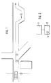
- FIG. 1 shows part of a street map
- FIG. 2 shows a block diagram of the location and / or navigation system on which the claimed method is based.
- FIG. 1 shows part of a road map on which a land vehicle motor vehicle drives from a non-plan-based area into a plan-based area.
- the plan-supported area has a street intersection as a striking position and a parking bay in the further course of the street.
- various marking points 1 to 4 are attached, which are explained in more detail below.
- the roads to be driven have no markings in themselves that are recognized by the location and / or navigation system 11.
- the location and / or navigation system 11 is essentially based on the intersections, which are sufficiently defined, for example, by their names. Due to the true-to-scale storage of the road map, the location can be located at any time by continuously measuring the distance covered and the changes in direction of the land vehicle.
- the land vehicle motor vehicle moves to the right at the dividing line 1 lying plan-based area.
- the dividing line 1 is of course not marked on the road, so that the driver cannot enter his position here.
- the next meaningful entry of the position will be the intersection, which is marked by the marking 3.
- the marking 3 For the location and / or navigation system 11, it is most advantageous if the center of the intersection is marked.
- the driver When crossing the center of the intersection, the driver will transmit this position to the location and / or navigation system 11 by pressing a button 13. Since he cannot stop at the middle of the intersection in the determined position 3, for example to enter the name of this intersection, he will continue his journey until he finds an opportunity to stop. This opportunity arises in the later position 4. Here he will stop his vehicle and enter the data of the specific position 3.
- the positioning and / or navigation system 11 will determine the coupling data for the specific position 3 exactly from the distance covered and the angle changes that the land vehicle has traveled between the positions 3 and 4. Based on the street names entered for the specific position 3, the location and / or navigation system 11 can now search the stored data for this intersection from the stored data of the compact disc. The position for placing the location and / or navigation system 11 is thus precisely defined. The route search system can now find the cheapest route to the specified destination from the available data and display it to the driver on the monitor.
- the location and / or navigation system 11 would make a location error. In the course of the further route this location error would be carried along and lead to further errors. This could then lead to incorrect guidance information being output by the location and / or navigation system 11.
- the mark the determined position 3 by the marking device 13 and the later definition of this position have the effect that the location error is minimized.
Landscapes
- Engineering & Computer Science (AREA)
- Radar, Positioning & Navigation (AREA)
- Remote Sensing (AREA)
- Automation & Control Theory (AREA)
- Physics & Mathematics (AREA)
- General Physics & Mathematics (AREA)
- Navigation (AREA)
- Traffic Control Systems (AREA)
Abstract
Claims (1)
- Procédé de repérage ou de navigation assisté par une carte routière pour un véhicule, dans lequel un système de repérage ou de navigation (11) avec une entrée de données (12) pour l'entrée des données de la position par un avantageux dispositif de marquage (13) sous la forme d'un clavier à touches et où le trajet parcouru et les changements de direction du véhicule sont communiqués et mémorisés depuis la mise en route du système (11), procédé caractérisé en ce que on entre les données de la première position (3) du véhicule en tant que position de départ en actionnant le dispositif de marquage (13) par la suite dans une seconde position ultérieure (4) qui se trouve localisée après la première position et en ce qu'après avoir entré les données de la position de départ on positionne le système (11) sur la première position (3) déterminée dans la carte routière mémorisée et pour déterminer la seconde position (4) du véhicule, on pointe la distance à parcourir sur la carte routière mémorisée pour le procédé de repérage et de navigation.
Applications Claiming Priority (2)
| Application Number | Priority Date | Filing Date | Title |
|---|---|---|---|
| DE3830901 | 1988-09-10 | ||
| DE3830901A DE3830901A1 (de) | 1988-09-10 | 1988-09-10 | Plangestuetztes ortungs- und navigationsystem |
Publications (2)
| Publication Number | Publication Date |
|---|---|
| EP0433287A1 EP0433287A1 (fr) | 1991-06-26 |
| EP0433287B1 true EP0433287B1 (fr) | 1993-08-04 |
Family
ID=6362744
Family Applications (1)
| Application Number | Title | Priority Date | Filing Date |
|---|---|---|---|
| EP89905634A Expired - Lifetime EP0433287B1 (fr) | 1988-09-10 | 1989-05-24 | Systeme de reperage et de navigation assiste par plan geographique |
Country Status (3)
| Country | Link |
|---|---|
| EP (1) | EP0433287B1 (fr) |
| DE (2) | DE3830901A1 (fr) |
| WO (1) | WO1990002922A1 (fr) |
Family Cites Families (4)
| Publication number | Priority date | Publication date | Assignee | Title |
|---|---|---|---|---|
| DE3319208A1 (de) * | 1983-05-27 | 1984-11-29 | Vdo Adolf Schindling Ag, 6000 Frankfurt | Navigationseinrichtung |
| JPS60239791A (ja) * | 1984-05-15 | 1985-11-28 | 三菱電機株式会社 | 車輛ナビゲ−シヨン装置 |
| DE3512127A1 (de) * | 1985-04-03 | 1986-10-16 | Robert Bosch Gmbh, 7000 Stuttgart | Ortungs- und navigationssystem fuer landfahrzeuge |
| KR900008856B1 (ko) * | 1986-06-12 | 1990-12-11 | 미쓰비시 뎅끼 가부시끼가이샤 | 차재용 주행정보 표시장치 |
-
1988
- 1988-09-10 DE DE3830901A patent/DE3830901A1/de not_active Withdrawn
-
1989
- 1989-05-24 WO PCT/DE1989/000325 patent/WO1990002922A1/fr not_active Ceased
- 1989-05-24 EP EP89905634A patent/EP0433287B1/fr not_active Expired - Lifetime
- 1989-05-24 DE DE8989905634T patent/DE58905183D1/de not_active Expired - Fee Related
Also Published As
| Publication number | Publication date |
|---|---|
| DE3830901A1 (de) | 1990-03-22 |
| DE58905183D1 (de) | 1993-09-09 |
| WO1990002922A1 (fr) | 1990-03-22 |
| EP0433287A1 (fr) | 1991-06-26 |
Similar Documents
| Publication | Publication Date | Title |
|---|---|---|
| DE69319193T2 (de) | Navigationssystem mittels Sprache | |
| DE2925656C2 (fr) | ||
| EP1269119B1 (fr) | Procede pour entrer une destination dans un appareil de navigation | |
| DE112005000059B4 (de) | Autonavigationsvorrichtung | |
| DE3855162T2 (de) | Navigationssystem für fahrzeuge | |
| EP1147375B1 (fr) | Procede pour guider le pilote d'un vehicule entre au moins un point de depart et au moins un point de destination | |
| DE2941331A1 (de) | Autarke navigationseinrichtung fuer strassenfahrzeuge | |
| DE10034499A1 (de) | Informations- und Steuerungssystem für Fahrzeuge | |
| DE102007033461A1 (de) | Navigationssystem | |
| DE3905493C2 (de) | Ortungs- und Navigationssystem für Landfahrzeuge | |
| DE19519066A1 (de) | Verfahren und System zur Zielführung eines Fahrzeugs | |
| EP1062481B1 (fr) | Procede d'affichage d'informations de trafic | |
| EP0410137B1 (fr) | Méthode et dispositif de commande d'un appareil de reproduction d'informations dépendant de la localisation | |
| EP0881613B1 (fr) | Méthode pour détecter l'instant d'actionnement des indicateurs de direction pour véhicules | |
| EP0715289B1 (fr) | Procédé et système pour le guidage d'un véhicule | |
| EP1192418B1 (fr) | Appareil de navigation | |
| DE10305453A1 (de) | Navigationsvorrichtung und Navigationsverfahren | |
| DE10218340A1 (de) | Navigationssystem und Verfahren zur Routenbestimmung | |
| DE69326114T2 (de) | Verfahren und Vorrichtung zur Fahrzeugführung auf Verkehrsstrassen | |
| DE102006027832A1 (de) | Fahrzeugnavigationssystem | |
| DE102007057989B4 (de) | Vorrichtung zur Navigation | |
| DE102016122200A1 (de) | Bilden einer Rettungsgasse unter Berücksichtigung deren Notwendigkeit | |
| DE19516964A1 (de) | System zur individuellen, fahrzeugautonomen Zielführung für Straßenfahrzeuge | |
| DE19933345A1 (de) | Verfahren zur Routenplanung und Verfahren zur Zielführung eines Fahrzeugführers | |
| EP0433287B1 (fr) | Systeme de reperage et de navigation assiste par plan geographique |
Legal Events
| Date | Code | Title | Description |
|---|---|---|---|
| PUAI | Public reference made under article 153(3) epc to a published international application that has entered the european phase |
Free format text: ORIGINAL CODE: 0009012 |
|
| 17P | Request for examination filed |
Effective date: 19901208 |
|
| AK | Designated contracting states |
Kind code of ref document: A1 Designated state(s): DE FR GB |
|
| 17Q | First examination report despatched |
Effective date: 19910912 |
|
| RAP3 | Party data changed (applicant data changed or rights of an application transferred) |
Owner name: ROBERT BOSCH GMBH |
|
| GRAA | (expected) grant |
Free format text: ORIGINAL CODE: 0009210 |
|
| AK | Designated contracting states |
Kind code of ref document: B1 Designated state(s): DE FR GB |
|
| GBT | Gb: translation of ep patent filed (gb section 77(6)(a)/1977) |
Effective date: 19930806 |
|
| REF | Corresponds to: |
Ref document number: 58905183 Country of ref document: DE Date of ref document: 19930909 |
|
| ET | Fr: translation filed | ||
| PLBE | No opposition filed within time limit |
Free format text: ORIGINAL CODE: 0009261 |
|
| STAA | Information on the status of an ep patent application or granted ep patent |
Free format text: STATUS: NO OPPOSITION FILED WITHIN TIME LIMIT |
|
| 26N | No opposition filed | ||
| REG | Reference to a national code |
Ref country code: GB Ref legal event code: IF02 |
|
| PGFP | Annual fee paid to national office [announced via postgrant information from national office to epo] |
Ref country code: DE Payment date: 20070726 Year of fee payment: 19 |
|
| PGFP | Annual fee paid to national office [announced via postgrant information from national office to epo] |
Ref country code: GB Payment date: 20070523 Year of fee payment: 19 |
|
| PGFP | Annual fee paid to national office [announced via postgrant information from national office to epo] |
Ref country code: FR Payment date: 20070518 Year of fee payment: 19 |
|
| GBPC | Gb: european patent ceased through non-payment of renewal fee |
Effective date: 20080524 |
|
| REG | Reference to a national code |
Ref country code: FR Ref legal event code: ST Effective date: 20090119 |
|
| PG25 | Lapsed in a contracting state [announced via postgrant information from national office to epo] |
Ref country code: DE Free format text: LAPSE BECAUSE OF NON-PAYMENT OF DUE FEES Effective date: 20081202 Ref country code: FR Free format text: LAPSE BECAUSE OF NON-PAYMENT OF DUE FEES Effective date: 20080602 |
|
| PG25 | Lapsed in a contracting state [announced via postgrant information from national office to epo] |
Ref country code: GB Free format text: LAPSE BECAUSE OF NON-PAYMENT OF DUE FEES Effective date: 20080524 |