EP0478438B1 - Bordempfänger für Fahrzeugsnavigationshilfe - Google Patents
Bordempfänger für Fahrzeugsnavigationshilfe Download PDFInfo
- Publication number
- EP0478438B1 EP0478438B1 EP91402534A EP91402534A EP0478438B1 EP 0478438 B1 EP0478438 B1 EP 0478438B1 EP 91402534 A EP91402534 A EP 91402534A EP 91402534 A EP91402534 A EP 91402534A EP 0478438 B1 EP0478438 B1 EP 0478438B1
- Authority
- EP
- European Patent Office
- Prior art keywords
- receiver
- pixels
- messages
- section
- locations
- Prior art date
- Legal status (The legal status is an assumption and is not a legal conclusion. Google has not performed a legal analysis and makes no representation as to the accuracy of the status listed.)
- Expired - Lifetime
Links
- 230000015654 memory Effects 0.000 claims abstract description 19
- 230000000694 effects Effects 0.000 claims abstract description 8
- 238000006467 substitution reaction Methods 0.000 claims abstract description 3
- 238000012800 visualization Methods 0.000 claims description 6
- 238000012545 processing Methods 0.000 claims description 5
- 230000000007 visual effect Effects 0.000 abstract 1
- 239000013598 vector Substances 0.000 description 5
- 238000012937 correction Methods 0.000 description 4
- 230000006870 function Effects 0.000 description 4
- 238000011144 upstream manufacturing Methods 0.000 description 4
- 230000015572 biosynthetic process Effects 0.000 description 1
- 238000004891 communication Methods 0.000 description 1
- 238000007796 conventional method Methods 0.000 description 1
- 239000011159 matrix material Substances 0.000 description 1
- 238000005259 measurement Methods 0.000 description 1
- 238000000034 method Methods 0.000 description 1
- 238000009877 rendering Methods 0.000 description 1
- 230000000717 retained effect Effects 0.000 description 1
- 238000003786 synthesis reaction Methods 0.000 description 1
- 230000001755 vocal effect Effects 0.000 description 1
Images

Classifications
-
- G—PHYSICS
- G01—MEASURING; TESTING
- G01C—MEASURING DISTANCES, LEVELS OR BEARINGS; SURVEYING; NAVIGATION; GYROSCOPIC INSTRUMENTS; PHOTOGRAMMETRY OR VIDEOGRAMMETRY
- G01C21/00—Navigation; Navigational instruments not provided for in groups G01C1/00 - G01C19/00
- G01C21/26—Navigation; Navigational instruments not provided for in groups G01C1/00 - G01C19/00 specially adapted for navigation in a road network
- G01C21/34—Route searching; Route guidance
- G01C21/36—Input/output arrangements for on-board computers
- G01C21/3691—Retrieval, searching and output of information related to real-time traffic, weather, or environmental conditions
- G01C21/3694—Output thereof on a road map
-
- G—PHYSICS
- G08—SIGNALLING
- G08G—TRAFFIC CONTROL SYSTEMS
- G08G1/00—Traffic control systems for road vehicles
- G08G1/09—Arrangements for giving variable traffic instructions
- G08G1/0962—Arrangements for giving variable traffic instructions having an indicator mounted inside the vehicle, e.g. giving voice messages
- G08G1/0968—Systems involving transmission of navigation instructions to the vehicle
- G08G1/0969—Systems involving transmission of navigation instructions to the vehicle having a display in the form of a map
Definitions
- the present invention relates to a vehicle navigation aid on-board receiver intended to receive, by transmitters and a specific broadcasting channel, coded messages containing at least problem locations of a finite sequence of locations stored in memory. the receiver and comprising means for decoding the messages and means for restoring them in a form accessible to a motorist.
- radio data system RDS Radio Data System
- TMC Traffic message channel
- the RDS system is based on a reference table, containing in particular numbers that are unequivocally associated with predetermined problem locations.
- the problem location table (PL table) is stored in the on-board receiver.
- Information on a problem can be associated with advice (turn away from X), information on weather conditions, etc.
- an RDS receiver receiving a coded problem message, decodes its cause, its effect as well as, using the stored table PL, the number or numbers of locations of the problem before, using a synthesizer, to restore the message in voice form (slowdown from A to B due to an accident, for example).
- the present invention relates to a vehicle navigation aid on-board receiver intended to receive, by transmitters and a specific broadcasting channel, coded messages containing at least problem locations of a finite sequence of locations stored in the receiver and comprising means for decoding messages and means for restoring them in a form accessible to a motorist, receiver characterized in that it includes a memory for storing pixels representative of road maps, means for displaying portions of these maps on display means and means for graphically restoring the location of messages problems on the display means, arranged for, when a traffic problem produces its effects on a section of road between two points, materializing this problem section on a portion of the displayed map by substituting, for the pixels of the section of the displayed portion of the map, pixels of a particular color.
- a card memorized in the form of a matrix or matrices of elementary image points, or pixels, for example a scanned card is distinguished from a vectorized card which, for its part, is memorized in the form of nodes and road axes.
- the receiver of the invention in its essential functions, is intended to be inserted in a system, not of navigation, but of aid to navigation, that is to say to receive messages on traffic conditions, leaving the motorist free to navigate, not on how to get from one point to another.
- the advantage of the receiver of the invention compared to that of the prior art with vocal restitution of messages, resides in the visualization in real time of the problems directly on real maps displayed.
- the graphical rendering of problem locations each being performed on few bits, approximately one byte, does not require a large capacity processing memory.
- the starting point of the invention is the RDS system, in which the display of maps, in any form whatsoever, was absolutely not intended.
- the display of maps was however known elsewhere.
- maps, synthetic and not real are displayed in the form of lines on which a motorist can materialize the position of his vehicle using a device magnetometric.
- the inventive step of the present invention therefore consisted of combining a navigation aid system of the RDS type with combining it with a variant of a navigation system, a priori incompatible with each other, in order to propose a system providing a result never achieved by either of the two systems of the prior art.
- said means for replacing the pixels of the receiver of the invention include means for recognizing contours to recognize those of said section of problem road.
- the display of the card portions takes place in color.
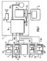
- the central unit 1 comprises a main processor 8, a graphics processor 9, a speech synthesis unit 10, connected to the processor 8, a mass memory 11 and a video memory 12, here a RAM, connected, to the main processor 8, by a bus 121.
- Each of the blocks 3, 4, 6 and 7 here comprises a microprocessor 31, 41, 61 and 71, respectively, whose memories, ROM and RAM, have not been shown for the sake of clarity. Nor have all the inter-processor link circuits been represented. It will also be noted that the functions of all or part of the microprocessors 31, 41, 61 and even of the blocks 3, 4, 6 could in fact be integrated with those of the main processor 8 of the central unit 1.
- the graphics terminal 2 connected to the graphics processor 9 by the video RAM 12 and controlled by circuits of the processor 9, constitutes the interface between the motorist and the receiver.
- it includes a high resolution color screen for displaying and viewing portions of road maps, control push buttons, for example to allow scrolling of maps, and adjustment potentiometers constituting designators connected to processor 9.
- the block 3 for processing broadcast messages here of the RDS type, comprises, connected to the microprocessor 31, a circuit 32 for receiving digital information transmitted by RDS transmitters and transmitted on the TMC channel, for decoding this information, sorting the relevant messages and sending these messages to the main processor 8 of the central unit 1 to which the microprocessor 31 is connected by a serial line 33.
- the RDS system is defined in a specification of the European Broadcasting Union, published in March 1984 and bearing the reference Tech. 3244-F.
- the block 4 for determining the heading of the vehicle comprises a magnetometer 42 connected to the microprocessor 41 for, from the measurement of the terrestrial magnetic field, deliver to the main processor 8 of the central unit 1, by a serial line 43, the heading followed by the vehicle.
- the block 5 for determining the distance traveled essentially comprises a counter controlled by an odometer and connected to the main processor 8.
- the block 6 for determining the position of the vehicle provides, in a known manner, an accuracy making it possible to follow the maps regardless of the duration of the trip or to permanently maintain the map presented on the screen centered on the position of the vehicle.
- the block 6 is inserted in a satellite system and comprises a reception circuit 62 connected to the microprocessor 61 also connected to the main processor 8 by a serial line 65.
- a reception circuit 62 connected to the microprocessor 61 also connected to the main processor 8 by a serial line 65.
- Block 7 completes the receiver of the invention in an attractive but not essential manner. It allows access to private and paid services using a memory card.
- Block 7 includes a bi-standard reader 72, for example of the type described in French patent application 2,638,876 in the name of the applicant, connected to microprocessor 71, itself connected to processor 8, and arranged to read indifferently CP8 type memory cards of low capacity and not writable or memory cards, of larger capacity, up to a few hundred thousand bytes (KB), and possibly writable.
- the services offered using block 7 can be diverse and varied, such as, for example, access to GPS correction information or to a radiotelephone system.
- a memory card intended to be used in connection with this block 7 can also serve as electronic anti-theft and even as a key for adjusting certain equipment of the vehicle.
- the memory card can also contain a database on a network of services useful for a road trip, such as the location, for example, of hotels, parking lots, petrol stations.
- the memory card can also be used as a recording medium for events occurring on board the vehicle to better manage and maintain it.
- the mass memory 11 contains all the databases useful for the operation of the receiver and in particular the cartographic databases (bit map) for the graphic terminus 2, more precisely pixels representative of road maps, for example scanned road maps.
- Mass memory can hold databases for an entire country. In this case, it has a very large capacity of several hundred KB (it can be for example a CD ROM memory) and it is materially independent from the central unit 1.
- the memory 11 can also, as in the case shown, contain only the databases relating to a region. It then has only an average capacity (it may be a hard disk) and it is integrated into the central unit 1. It is downloadable and connected to the processor 8 by a bus 111.
- the problem locations are stored in mass memory 11.
- the receiver In its function of displaying in real time traffic problems on the portions of cards displayed on the screen of terminal 2, the receiver operates in the following manner. A portion of the map being displayed on the screen, the center of which represents, as indicated above with respect to block 6, the position of the vehicle, arrives on block 3 a problem message, transmitted to processor 8. If the problem is not located on the portion of decay then displayed on the screen, nothing happens that the motorist can perceive. On the other hand, if the problem produces its effects in a place appearing on the screen, the processor 8 restores the problem on the screen and materializes it on the base map here using pointing icons. A sound reproduction by block 10 can be combined with graphic reproduction. Note that the receiver is capable of processing several messages simultaneously.
- the tracking of the maps can be automatic, thanks to the "GPS” or “differential GPS” function of block 6, it can also be carried out only semi-automatically, using the only dead reckoning of blocks 4, 5, or even purely manual, using the scrolling commands of the graphic terminal 2.
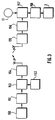
- the processor 8 for the visualization of this section, substitutes, for the pixels of the considered section of the portion of map displayed, pixels of a particular color, here black pixels. This substitution is carried out by recognizing the contours of the road section of the map according to a conventional method of contour recognition or that which will now be described with reference to FIG. 2.
- the receiver of the invention is inserted into a global system which makes it possible to increment, dynamically and in real time, on a background map, traffic problems by modifying the color of route plots, the system can be schematically defined by the chain of Figure 3.
- Means 150 of seizure (police, gendarmerie, municipalities, ...) transmit to a collection center 151 messages of problems. Thanks to a reference table 152, these messages are formatted and coded (153) before being transmitted by transmitters 154. These messages are received (155) by the receiver described above, which decodes them (156) and, thanks to the cartographic databases and to the problem locations stored in the mass memory 11, actually locates the problems (157) and, by recognizing contours (158) displays them dynamically on a screen of display terminal 2.
Landscapes
- Engineering & Computer Science (AREA)
- Radar, Positioning & Navigation (AREA)
- Remote Sensing (AREA)
- General Physics & Mathematics (AREA)
- Physics & Mathematics (AREA)
- Ecology (AREA)
- Environmental Sciences (AREA)
- Environmental & Geological Engineering (AREA)
- Life Sciences & Earth Sciences (AREA)
- Automation & Control Theory (AREA)
- Biodiversity & Conservation Biology (AREA)
- Atmospheric Sciences (AREA)
- Navigation (AREA)
- Circuits Of Receivers In General (AREA)
- Radar Systems Or Details Thereof (AREA)
- Instructional Devices (AREA)
- Position Fixing By Use Of Radio Waves (AREA)
- Mobile Radio Communication Systems (AREA)
Claims (6)
- Bordempfänger zur Kraftfahrzeugnavigationshilfe, der dazu bestimmt ist, über Sender (154) und einen spezifischen Rundfunkkanal kodierte Meldungen zu empfangen, die zumindest Orte von Verkehrsproblemen aus einer endlichen Folge von im Empfänger in einem Speicher (11) gespeicherten Orten zu empfangen, und Mittel (32) zum Dekodieren von Meldungen und Mittel (8-12, 2) zu deren Wiedergabe in für einen Kraftfahrer zugänglicher Form aufweist, dabei ist der Empfänger dadurch gekennzeichnet,
daß er einen Speicher (11) zum Speichern von Straßenkarten darstellenden Pixeln, Mittel (8) zum Darstellen von Teilen dieser Karten auf Darstellungseinrichtungen (2) und Mittel (8) zur graphischen Wiedergabe der Orte der in Form der genannten Meldungen kodierten Verkehrsprobleme auf den Darstellungseinrichtungen (2) aufweist, die ausgebildet sind, um bei Auftreten eines Verkehrsproblems auf einem Straßenabschnitt zwischen zwei Punkten (A, B) diesen Problemabschnitt auf einem dargestellten Kartenteil sichtbar zu machen, indem die Pixel des Abschnitts des dargestellten Kartenteils durch Pixel mit einer besonderen Farbe ersetzt werden. - Empfänger nach Anspruch 1,
in dem die genannten Mittel zum Ersetzen von Pixeln Umrißerkennungsmittel (8) zum Erkennen der Umrisse dieses Problemstraßenabschnitts umfassen. - Empfänger nach einem der Ansprüche 1 und 2,
in dem ein Block (3) zur Verarbeitung von Rundfunkmeldungen vom Typ RDS vorgesehen ist. - Empfänger nach einem der Ansprüche 1 bis 3,
in dem ein Block (4) zur Kursbestimmung vorgesehen ist. - Empfänger nach einem der Ansprüche 1 bis 4,
in dem ein Block (5) zur Bestimmung der zurückgelegten Strecke vorgesehen ist. - Empfänger nach einem der Ansprüche 1 bis 5,
in dem ein Block (6) zur Standortbestimmung vorgesehen ist.
Applications Claiming Priority (2)
| Application Number | Priority Date | Filing Date | Title |
|---|---|---|---|
| FR9011993 | 1990-09-28 | ||
| FR9011993A FR2667423B1 (fr) | 1990-09-28 | 1990-09-28 | Recepteur de bord d'aide a la navigation automobile. |
Publications (2)
| Publication Number | Publication Date |
|---|---|
| EP0478438A1 EP0478438A1 (de) | 1992-04-01 |
| EP0478438B1 true EP0478438B1 (de) | 1995-12-13 |
Family
ID=9400758
Family Applications (1)
| Application Number | Title | Priority Date | Filing Date |
|---|---|---|---|
| EP91402534A Expired - Lifetime EP0478438B1 (de) | 1990-09-28 | 1991-09-24 | Bordempfänger für Fahrzeugsnavigationshilfe |
Country Status (7)
| Country | Link |
|---|---|
| EP (1) | EP0478438B1 (de) |
| JP (1) | JPH04305684A (de) |
| AT (1) | ATE131650T1 (de) |
| CA (1) | CA2052370A1 (de) |
| DE (1) | DE69115417T2 (de) |
| ES (1) | ES2080924T3 (de) |
| FR (1) | FR2667423B1 (de) |
Cited By (7)
| Publication number | Priority date | Publication date | Assignee | Title |
|---|---|---|---|---|
| US6920392B2 (en) | 2001-04-27 | 2005-07-19 | Matsushita Electric Industrial Co., Ltd. | Digital map position transfer method |
| US6931319B2 (en) | 2000-12-08 | 2005-08-16 | Matsushita Electric Industrial Co., Ltd. | Method for transmitting information on position on digital map and device used for the same |
| US7353108B2 (en) | 2001-01-29 | 2008-04-01 | Matsushita Electric Industrial Co., Ltd. | Method and apparatus for transmitting position information on a digital map |
| US7539348B2 (en) | 2001-05-01 | 2009-05-26 | Panasonic Corporation | Digital map shape vector encoding method and position information transfer method |
| US7634452B2 (en) | 1999-08-27 | 2009-12-15 | Panasonic Corporation | Method for locating road shapes using erroneous map data |
| US8219314B2 (en) | 1999-07-28 | 2012-07-10 | Panasonic Corporation | Method for transmitting location information on a digital map, apparatus for implementing the method and traffic information provision/reception system |
| US8554475B2 (en) | 2007-10-01 | 2013-10-08 | Mitac International Corporation | Static and dynamic contours |
Families Citing this family (10)
| Publication number | Priority date | Publication date | Assignee | Title |
|---|---|---|---|---|
| GB2271420A (en) * | 1992-10-07 | 1994-04-13 | Ford Motor Co | Vehicle navigation system |
| SE516278C2 (sv) * | 1994-03-04 | 2001-12-10 | Volvo Ab | Trafikinformationssystem och förfarande för tillhandahållande av trafikinformation |
| US6111521A (en) * | 1996-09-18 | 2000-08-29 | Mannesmann Vdo Ag | Apparatus for supplying traffic-related information |
| DE19724556A1 (de) * | 1997-06-11 | 1998-12-17 | Opel Adam Ag | Unidirektionales Off-Board-Navigationssystem |
| DE69817306T2 (de) | 1997-12-02 | 2004-06-24 | Siemens Ag | Gerät zur Verarbeitung einer Verkehrsmeldung |
| KR100304831B1 (ko) * | 1998-03-05 | 2001-11-22 | 김부성 | 교통정보 수신 방법 및 장치 |
| US6873907B1 (en) | 1998-05-05 | 2005-03-29 | Magellan Dis, Inc. | Navigation system with user interface |
| AU4070799A (en) * | 1998-05-05 | 1999-11-23 | Magellan Dis, Inc. | Navigation system with user interface |
| DE19822918A1 (de) * | 1998-05-22 | 1999-11-25 | Bosch Gmbh Robert | Einrichtung zur grafischen Markierung eines Straßenverlaufs unter Zuhilfenahme einer Ortsdatenbank |
| CN113483750A (zh) * | 2021-07-06 | 2021-10-08 | 中铁十九局集团第五工程有限公司 | 一种研制施工现场巡检用具有定位功能的数据记录仪 |
Family Cites Families (2)
| Publication number | Priority date | Publication date | Assignee | Title |
|---|---|---|---|---|
| US4409583A (en) * | 1981-02-23 | 1983-10-11 | Dahan Pierre Louis | Video system for assisting automobile traffic employing a segmented LCD display |
| DE3853719T2 (de) * | 1987-12-28 | 1995-10-05 | Aisin Aw Co | Wegsuchverfahren für navigationssystem. |
-
1990
- 1990-09-28 FR FR9011993A patent/FR2667423B1/fr not_active Expired - Fee Related
-
1991
- 1991-09-24 ES ES91402534T patent/ES2080924T3/es not_active Expired - Lifetime
- 1991-09-24 AT AT91402534T patent/ATE131650T1/de not_active IP Right Cessation
- 1991-09-24 EP EP91402534A patent/EP0478438B1/de not_active Expired - Lifetime
- 1991-09-24 DE DE69115417T patent/DE69115417T2/de not_active Expired - Lifetime
- 1991-09-27 CA CA002052370A patent/CA2052370A1/fr not_active Abandoned
- 1991-09-27 JP JP3249607A patent/JPH04305684A/ja active Pending
Cited By (12)
| Publication number | Priority date | Publication date | Assignee | Title |
|---|---|---|---|---|
| US8219314B2 (en) | 1999-07-28 | 2012-07-10 | Panasonic Corporation | Method for transmitting location information on a digital map, apparatus for implementing the method and traffic information provision/reception system |
| US8838386B2 (en) | 1999-07-28 | 2014-09-16 | Panasonic Intellectual Property Corporation Of America | Method for transmitting location information on a digital map, apparatus for implementing the method, and traffic information provision/reception system |
| US7634452B2 (en) | 1999-08-27 | 2009-12-15 | Panasonic Corporation | Method for locating road shapes using erroneous map data |
| US8078563B2 (en) | 1999-08-27 | 2011-12-13 | Panasonic Corporation | Method for locating road shapes using erroneous map data |
| US6931319B2 (en) | 2000-12-08 | 2005-08-16 | Matsushita Electric Industrial Co., Ltd. | Method for transmitting information on position on digital map and device used for the same |
| US8655580B2 (en) | 2000-12-08 | 2014-02-18 | Panasonic Corporation | Method for transmitting information on position on digital map and device used for the same |
| US7353108B2 (en) | 2001-01-29 | 2008-04-01 | Matsushita Electric Industrial Co., Ltd. | Method and apparatus for transmitting position information on a digital map |
| US8185306B2 (en) | 2001-01-29 | 2012-05-22 | Panasonic Corporation | Method and apparatus for transmitting position information on a digital map |
| US6920392B2 (en) | 2001-04-27 | 2005-07-19 | Matsushita Electric Industrial Co., Ltd. | Digital map position transfer method |
| US9177487B2 (en) | 2001-04-27 | 2015-11-03 | Panasonic Intellectual Property Corporation Of America | Digital map position information transfer method |
| US7539348B2 (en) | 2001-05-01 | 2009-05-26 | Panasonic Corporation | Digital map shape vector encoding method and position information transfer method |
| US8554475B2 (en) | 2007-10-01 | 2013-10-08 | Mitac International Corporation | Static and dynamic contours |
Also Published As
| Publication number | Publication date |
|---|---|
| ATE131650T1 (de) | 1995-12-15 |
| EP0478438A1 (de) | 1992-04-01 |
| CA2052370A1 (fr) | 1992-03-29 |
| DE69115417T2 (de) | 1996-05-30 |
| JPH04305684A (ja) | 1992-10-28 |
| FR2667423A1 (fr) | 1992-04-03 |
| FR2667423B1 (fr) | 1995-05-24 |
| ES2080924T3 (es) | 1996-02-16 |
| DE69115417D1 (de) | 1996-01-25 |
Similar Documents
| Publication | Publication Date | Title |
|---|---|---|
| EP0478438B1 (de) | Bordempfänger für Fahrzeugsnavigationshilfe | |
| EP0974137B1 (de) | Verfahren zur interaktiven navigationshilfe und vorrichtung dazu | |
| US6246958B1 (en) | Apparatus and method for processing information and apparatus and method for displaying image | |
| CA2158500C (en) | Navigation system for an automotive vehicle | |
| EP1544574B1 (de) | Informationsverteilungssystem und -verfahren | |
| KR20060062464A (ko) | 디지털 멀티미디어 방송을 이용한 영상 피 오 아이 서비스방법 | |
| JPH0990869A (ja) | 地図関連情報配信システム | |
| FR2801158A1 (fr) | Appareil portable comportant des moyens d'orientation procede d'utilisation d'un tel appareil et procede d'orientation correspondant | |
| US20040044470A1 (en) | Method for route guidance, and terminal equipment and central apparatus for use therein | |
| EP1862762A1 (de) | System zur Bereitstellung eines Identifikators für Positionsinformationen sowie Übertragungsverfahren und -vorrichtung für einen Identifikator für Positionsinformationen | |
| JP4456667B2 (ja) | ナビゲーション装置 | |
| US20030069691A1 (en) | Navigation device for receiving satellite broadcast distribution of map data | |
| JP5125676B2 (ja) | 情報配信システム、センター装置、アンケート回答取得方法 | |
| EP0595685A1 (de) | Verfahren und Vorrichtung zur Fahrzeugführung auf Verkehrsstrassen | |
| US6594564B1 (en) | Data device for a motor vehicle | |
| JP2853775B2 (ja) | データ放送受信装置 | |
| EP1555512A1 (de) | Navigationsvorrichtung | |
| EP0925567B1 (de) | Verfahren zur lokalisierung eines notrufs | |
| JP4403736B2 (ja) | ナビゲーションシステム及びプログラム | |
| JPH07320192A (ja) | 交通情報表示装置 | |
| JP2004289269A (ja) | 移動体通信システム、情報提供装置および移動体通信端末 | |
| US7593970B2 (en) | Data receiving system, data broadcasting system, data receiving method and data broadcasting method | |
| FR2709545A1 (fr) | Procédé interactif d'aide à la navigation, notamment routière, et dispositif pour sa mise en Óoeuvre. | |
| FR3109434A1 (fr) | Procédé de mise à jour d’un système de navigation d’un véhicule conforme à une réglementation | |
| JP2000171262A (ja) | カーナビゲーション情報の記録方法及び装置 |
Legal Events
| Date | Code | Title | Description |
|---|---|---|---|
| PUAI | Public reference made under article 153(3) epc to a published international application that has entered the european phase |
Free format text: ORIGINAL CODE: 0009012 |
|
| AK | Designated contracting states |
Kind code of ref document: A1 Designated state(s): AT BE CH DE ES FR GB IT LI LU NL SE |
|
| 17P | Request for examination filed |
Effective date: 19920928 |
|
| 17Q | First examination report despatched |
Effective date: 19950210 |
|
| GRAA | (expected) grant |
Free format text: ORIGINAL CODE: 0009210 |
|
| AK | Designated contracting states |
Kind code of ref document: B1 Designated state(s): AT BE CH DE ES FR GB IT LI LU NL SE |
|
| REF | Corresponds to: |
Ref document number: 131650 Country of ref document: AT Date of ref document: 19951215 Kind code of ref document: T |
|
| REF | Corresponds to: |
Ref document number: 69115417 Country of ref document: DE Date of ref document: 19960125 |
|
| REG | Reference to a national code |
Ref country code: ES Ref legal event code: FG2A Ref document number: 2080924 Country of ref document: ES Kind code of ref document: T3 |
|
| ITF | It: translation for a ep patent filed | ||
| GBT | Gb: translation of ep patent filed (gb section 77(6)(a)/1977) |
Effective date: 19960307 |
|
| PLBE | No opposition filed within time limit |
Free format text: ORIGINAL CODE: 0009261 |
|
| STAA | Information on the status of an ep patent application or granted ep patent |
Free format text: STATUS: NO OPPOSITION FILED WITHIN TIME LIMIT |
|
| 26N | No opposition filed | ||
| REG | Reference to a national code |
Ref country code: GB Ref legal event code: IF02 |
|
| PGFP | Annual fee paid to national office [announced via postgrant information from national office to epo] |
Ref country code: LU Payment date: 20030814 Year of fee payment: 13 Ref country code: AT Payment date: 20030814 Year of fee payment: 13 |
|
| PGFP | Annual fee paid to national office [announced via postgrant information from national office to epo] |
Ref country code: SE Payment date: 20030815 Year of fee payment: 13 |
|
| PGFP | Annual fee paid to national office [announced via postgrant information from national office to epo] |
Ref country code: NL Payment date: 20030818 Year of fee payment: 13 |
|
| PGFP | Annual fee paid to national office [announced via postgrant information from national office to epo] |
Ref country code: DE Payment date: 20030908 Year of fee payment: 13 |
|
| PGFP | Annual fee paid to national office [announced via postgrant information from national office to epo] |
Ref country code: ES Payment date: 20030915 Year of fee payment: 13 |
|
| PGFP | Annual fee paid to national office [announced via postgrant information from national office to epo] |
Ref country code: GB Payment date: 20030916 Year of fee payment: 13 Ref country code: CH Payment date: 20030916 Year of fee payment: 13 |
|
| PGFP | Annual fee paid to national office [announced via postgrant information from national office to epo] |
Ref country code: FR Payment date: 20030930 Year of fee payment: 13 |
|
| PGFP | Annual fee paid to national office [announced via postgrant information from national office to epo] |
Ref country code: BE Payment date: 20031010 Year of fee payment: 13 |
|
| PG25 | Lapsed in a contracting state [announced via postgrant information from national office to epo] |
Ref country code: DE Free format text: LAPSE BECAUSE OF THE APPLICANT RENOUNCES Effective date: 20040504 |
|
| PG25 | Lapsed in a contracting state [announced via postgrant information from national office to epo] |
Ref country code: LU Free format text: LAPSE BECAUSE OF NON-PAYMENT OF DUE FEES Effective date: 20040924 Ref country code: GB Free format text: LAPSE BECAUSE OF NON-PAYMENT OF DUE FEES Effective date: 20040924 Ref country code: AT Free format text: LAPSE BECAUSE OF NON-PAYMENT OF DUE FEES Effective date: 20040924 |
|
| PG25 | Lapsed in a contracting state [announced via postgrant information from national office to epo] |
Ref country code: SE Free format text: LAPSE BECAUSE OF NON-PAYMENT OF DUE FEES Effective date: 20040925 Ref country code: ES Free format text: LAPSE BECAUSE OF NON-PAYMENT OF DUE FEES Effective date: 20040925 |
|
| PG25 | Lapsed in a contracting state [announced via postgrant information from national office to epo] |
Ref country code: LI Free format text: LAPSE BECAUSE OF NON-PAYMENT OF DUE FEES Effective date: 20040930 Ref country code: CH Free format text: LAPSE BECAUSE OF NON-PAYMENT OF DUE FEES Effective date: 20040930 Ref country code: BE Free format text: LAPSE BECAUSE OF NON-PAYMENT OF DUE FEES Effective date: 20040930 |
|
| BERE | Be: lapsed |
Owner name: SOC. D'APPLICATIONS GENERALES D'ELECTRICITE ET DE Effective date: 20040930 |
|
| PG25 | Lapsed in a contracting state [announced via postgrant information from national office to epo] |
Ref country code: NL Free format text: LAPSE BECAUSE OF NON-PAYMENT OF DUE FEES Effective date: 20050401 |
|
| EUG | Se: european patent has lapsed | ||
| GBPC | Gb: european patent ceased through non-payment of renewal fee |
Effective date: 20040924 |
|
| REG | Reference to a national code |
Ref country code: CH Ref legal event code: PL |
|
| PG25 | Lapsed in a contracting state [announced via postgrant information from national office to epo] |
Ref country code: FR Free format text: LAPSE BECAUSE OF NON-PAYMENT OF DUE FEES Effective date: 20050531 |
|
| NLV4 | Nl: lapsed or anulled due to non-payment of the annual fee |
Effective date: 20050401 |
|
| REG | Reference to a national code |
Ref country code: FR Ref legal event code: ST |
|
| PG25 | Lapsed in a contracting state [announced via postgrant information from national office to epo] |
Ref country code: IT Free format text: LAPSE BECAUSE OF NON-PAYMENT OF DUE FEES;WARNING: LAPSES OF ITALIAN PATENTS WITH EFFECTIVE DATE BEFORE 2007 MAY HAVE OCCURRED AT ANY TIME BEFORE 2007. THE CORRECT EFFECTIVE DATE MAY BE DIFFERENT FROM THE ONE RECORDED. Effective date: 20050924 |
|
| REG | Reference to a national code |
Ref country code: ES Ref legal event code: FD2A Effective date: 20040925 |
|
| BERE | Be: lapsed |
Owner name: SOC. D'APPLICATIONS GENERALES D'ELECTRICITE ET DE Effective date: 20040930 |