EP0541314A2 - Funkübertragungsanordnung mit Datenbank für die Karte des bedekten Gebietes - Google Patents
Funkübertragungsanordnung mit Datenbank für die Karte des bedekten Gebietes Download PDFInfo
- Publication number
- EP0541314A2 EP0541314A2 EP92310005A EP92310005A EP0541314A2 EP 0541314 A2 EP0541314 A2 EP 0541314A2 EP 92310005 A EP92310005 A EP 92310005A EP 92310005 A EP92310005 A EP 92310005A EP 0541314 A2 EP0541314 A2 EP 0541314A2
- Authority
- EP
- European Patent Office
- Prior art keywords
- database
- location
- parameter
- radio communication
- radio
- Prior art date
- Legal status (The legal status is an assumption and is not a legal conclusion. Google has not performed a legal analysis and makes no representation as to the accuracy of the status listed.)
- Withdrawn
Links
Images

Classifications
-
- H—ELECTRICITY
- H04—ELECTRIC COMMUNICATION TECHNIQUE
- H04W—WIRELESS COMMUNICATION NETWORKS
- H04W16/00—Network planning, e.g. coverage or traffic planning tools; Network deployment, e.g. resource partitioning or cells structures
- H04W16/18—Network planning tools
Definitions
- the present invention relates to radio communication, particularly radio communication involving one or more mobile transmitter/receivers, e.g. in a cellular radio network.
- the preparation of a record of the radio coverage of geographical terrain for a given system is normally achieved by allocating a signal level value to each of many small squares defined in terms of Cartesian coordinates. This may apply to ground level or to any specified height above ground level, and requires the storage in some form, usually as a computer database, of a comparatively large amount of data.
- a TV broadcasting authority needs to maintain such a record in order to be able to respond to any queries about the expected signal strength of its transmissions at any location.
- the present invention is intended to provide the required information from fewer stored bits through the use of polar coordinates. It is remarkable that there does not appear to be any record of such previous use since polar coordinates are normally used to calculate the radiation from an aerial, for example.
- the present invention can function without any reference to geographic terrain, since it provides a database which is effectively a radio coverage map, or perhaps several maps for different systems, coupled with the location of an 'intelligent' mobile radio terminal in relation to such radio networks.
- fixel A new term has been generated to describe a unit of area within which a constant value of radio signal is assumed to exist, namely a "fixel". For improved accuracy the fixel should cover smaller areas, but this would require prohibitively large amounts of data storage as the unit becomes smaller.
- Polar coordinates provide more efficient means of formatting a record of radio coverage since radio transmitters usually radiate different amounts of power into different radial sectors and the attenuation characteristics for various sectors may also differ.
- fixel becomes a variable area formed by sector and radial boundaries closely related to natural laws of propagation, thus requiring fewer storage data bits.
- a radio communication system comprising radio transmitter and receiver equipment and a digital database of location-dependent values of a radio communication parameter, the database representing a map of an area divided up into a number of sub-areas of variable extent and to each of which a respective value of the parameter is ascribed, the areas being bounded by circular sectors centred on an origin location and pairs of radii from that origin.
- the invention is applicable to a SLIM (self-locating intelligent mobile) for use in mobile radio communication.
- a SLIM needs to know the signal strength available at a given location (which it can sense separately through systems such as Securicor's Datatrak (TM) network) and also the direction of the appropriate base station from that location so that directional aerials can be used to great advantage from several points of view. Better signals, less interference, and more advantageous re-use patterns result from this, as in the case of point-to-point communications.
- TM Securicor's Datatrak
- FIG. 1 illustrates in an idealised schematic form a map of part of a radio communication system embodying the present invention.
- a mobile M e.g. a cellular telephone in a moving vehicle
- a remote point not shown
- the communication system can be a cellular radio system in itself, or part of a cellular telephone system.
- transmitters L1-L4 which transmit signals in a lower part of the spectrum than the communications channels and which can be used by circuitry at the mobile to determine its location; such a facility is provided inter alia as part of the Datatrak (TM) system.
- This location information can be transmitted by the mobile to the base station with which it is in radio contact so that a communication is appropriately routed to it via the base station network.
- a section of the radio system is split up into a number of equal channels of, say, 5 KHz width, some channels being used for communication between subscribers for voice or data communications and others for transmitting trunking information and other system information between the base stations.
- the channel allocations in adjacent reception areas are chosen so as to strike a balance between co-channel interference, channel usage and other considerations.
- a database of such radio coverage information would be constructed by dividing a geographical area into a number of unit cells, specified by cartesian coordinates, and then assigning to each cell the appropriate data.
- the amount of digital data necessary to characterise the database would preclude its implementation in a form which would render its contents available to circuitry within a mobile, e.g. by storage in ROM ICs.
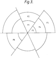
- the geographical area be divided up into the above mentioned "fixel" areas which, referred to some suitable origin, are bounded by two concentric areas and radii, as shown in Figure 2, and over which a particular value of the parameter in question can be taken to apply.
- the construction of the database is then conducted on the basis of:-
- Step 2), and Step 1) for that matter may be iterated as required so that the database adequately characterises the area of interest.
- a single set of fixels can be established, with suitable values of each parameter assigned to them.
- the database could comprise several separate fixel "overlays" each having a fixel configuration and set of fixel values for one or more of the parameters.
- FIG. 3 shows, in block diagram form, the mobile transceiver equipment of a mobile station in one embodiment of the invention. It comprises an aerial 1, a voice and/or data communications transceiver 3, a location determining unit 5 and a microprocessor sub-system 7.
- the microprocessor system comprises a microprocessor, memory 9, including ROM containing its operating instructions, working RAM and suitable interfacing to exchange data with and supply commands to the location determining unit 5 and the transceiver 3. In operation it receives the location data from the location determining unit 5, processes it to access the radio coverage database 9 and controls one or more parameters of the transceiver 3 in accordance with data looked up from the database.
- the microprocessor is programmed, by instructions stored in ROM 11 to perform the following steps:-
- a location determining system such as Datatrak can assist in this.
- a mobile microcomputer connected to a location determining unit and circuitry for measuring the parameter(s) of interest, the microcomputer being programmed to periodically log its current position and the parameter value(s) into a database stored in some suitable storage device such as a hard disk drive.
- a vehicle equipped with such a system could then be driven around an area of interest to compile or update the coverage database.
Landscapes
- Engineering & Computer Science (AREA)
- Computer Networks & Wireless Communication (AREA)
- Signal Processing (AREA)
- Mobile Radio Communication Systems (AREA)
Applications Claiming Priority (2)
| Application Number | Priority Date | Filing Date | Title |
|---|---|---|---|
| GB9123338A GB2261139B (en) | 1991-11-04 | 1991-11-04 | Improvements in or relating to radio communication |
| GB9123338 | 1991-11-04 |
Publications (2)
| Publication Number | Publication Date |
|---|---|
| EP0541314A2 true EP0541314A2 (de) | 1993-05-12 |
| EP0541314A3 EP0541314A3 (en) | 1994-11-17 |
Family
ID=10704006
Family Applications (1)
| Application Number | Title | Priority Date | Filing Date |
|---|---|---|---|
| EP19920310005 Withdrawn EP0541314A3 (en) | 1991-11-04 | 1992-11-02 | Radio communication system with database representing a map of the area covered |
Country Status (2)
| Country | Link |
|---|---|
| EP (1) | EP0541314A3 (de) |
| GB (1) | GB2261139B (de) |
Cited By (1)
| Publication number | Priority date | Publication date | Assignee | Title |
|---|---|---|---|---|
| WO1996024120A1 (en) * | 1995-02-02 | 1996-08-08 | Bror Erland Blom | Method and system for limitation of the range at remote control system |
Families Citing this family (2)
| Publication number | Priority date | Publication date | Assignee | Title |
|---|---|---|---|---|
| GB9823534D0 (en) * | 1998-10-28 | 1998-12-23 | Roke Manor Research | Method of and apparatus for signal receipt ability |
| GB2375267B (en) * | 2001-05-04 | 2006-02-22 | Nokia Corp | A communication system |
Family Cites Families (6)
| Publication number | Priority date | Publication date | Assignee | Title |
|---|---|---|---|---|
| GB2166325B (en) * | 1984-10-26 | 1988-06-02 | Philips Electronic Associated | A method of carrying-out a radio propagation survey |
| EP0292182B1 (de) * | 1987-05-15 | 1996-07-24 | Securicor Datatrak Limited | Mobiles Sende-Empfangsgerät |
| FR2621435B1 (fr) * | 1987-10-01 | 1994-08-05 | Systemes R | Procede et dispositif de localisation a distance de mobiles |
| DE3837633A1 (de) * | 1988-11-05 | 1990-05-10 | Bosch Gmbh Robert | Ortungs- und navigationssystem fuer mobile funkstationen |
| SE8903208L (sv) * | 1989-09-29 | 1991-03-30 | Televerket | Metod foer framstaellning av taeckningsgrad i ett mobilradiosystem |
| DE4017234A1 (de) * | 1990-05-29 | 1991-12-05 | Rohde & Schwarz | System zum aufbau von los-funkverbindungen von mobilen sende/empfangs-stationen zu anderen mobilen oder stationaeren gegenstationen |
-
1991
- 1991-11-04 GB GB9123338A patent/GB2261139B/en not_active Expired - Fee Related
-
1992
- 1992-11-02 EP EP19920310005 patent/EP0541314A3/en not_active Withdrawn
Cited By (1)
| Publication number | Priority date | Publication date | Assignee | Title |
|---|---|---|---|---|
| WO1996024120A1 (en) * | 1995-02-02 | 1996-08-08 | Bror Erland Blom | Method and system for limitation of the range at remote control system |
Also Published As
| Publication number | Publication date |
|---|---|
| GB9123338D0 (en) | 1991-12-18 |
| EP0541314A3 (en) | 1994-11-17 |
| GB2261139A (en) | 1993-05-05 |
| GB2261139B (en) | 1995-03-29 |
Similar Documents
| Publication | Publication Date | Title |
|---|---|---|
| US5752164A (en) | Autonomous remote measurement unit for a personal communications service system | |
| US5475866A (en) | System for informing secondary users of which radio channels are usable in which geographic region | |
| EP0700226B1 (de) | Verfahren und Geräte zur automatischen Auswahl einer Funksprechgruppe | |
| CA1327641C (en) | Mobile transmitter/receiver | |
| US5410737A (en) | Frequency agile sharing technology (FAST) for a personal communications service system | |
| KR100635319B1 (ko) | 이동 유닛의 속도 및 거리를 측정하는 방법 및 시스템 | |
| US5926762A (en) | Cellular telephone interference prediction and frequency reuse planning | |
| US6269246B1 (en) | Location determination using RF fingerprinting | |
| KR100310712B1 (ko) | 통신 시스템에서 지리 정보에 기초한 제어를 위한 방법 및 장치 | |
| GB2236457A (en) | Method for determining the degree of coverage in a mobile radio system | |
| US20010024957A1 (en) | Terminal unit, position display method, information providing system, and information providing method | |
| EP1258165A1 (de) | Positionsunterstützte dienstauswahl | |
| CA2240896A1 (en) | Telemetric measuring of a mobile telephone network | |
| JP4739671B2 (ja) | 携帯端末の位置特定システム及び方法 | |
| EP1481259A1 (de) | Verfahren zur positionierung von mobilstationen | |
| KR100626996B1 (ko) | 무선 통신 시스템에서 다운링크 동작 측정을 행하기 위한 방법 | |
| GB2313742A (en) | Channel allocation in a cellular communication system | |
| EP0541314A2 (de) | Funkübertragungsanordnung mit Datenbank für die Karte des bedekten Gebietes | |
| CN100566444C (zh) | 移动台的位置确定的方法 | |
| US8692703B1 (en) | Mapping, storage, retrieval and display of high energy electromagnetic radiation emitters | |
| US6968737B2 (en) | Position determining system using transmitted position information | |
| Mfupe et al. | Enabling dynamic spectrum access through location aware spectrum databases | |
| GB9516617D0 (en) | Wireless local area network system | |
| KR100456306B1 (ko) | 기지국 위치 설정 시스템 | |
| Shukla et al. | A tactical HF decision aid for inexperienced operators and automated HF systems |
Legal Events
| Date | Code | Title | Description |
|---|---|---|---|
| PUAI | Public reference made under article 153(3) epc to a published international application that has entered the european phase |
Free format text: ORIGINAL CODE: 0009012 |
|
| AK | Designated contracting states |
Kind code of ref document: A2 Designated state(s): AT BE CH DE DK ES FR GB GR IE IT LI LU NL PT SE |
|
| PUAL | Search report despatched |
Free format text: ORIGINAL CODE: 0009013 |
|
| AK | Designated contracting states |
Kind code of ref document: A3 Designated state(s): AT BE CH DE DK ES FR GB GR IE IT LI LU NL PT SE |
|
| RHK1 | Main classification (correction) |
Ipc: H04Q 7/04 |
|
| 17P | Request for examination filed |
Effective date: 19950110 |
|
| GRAG | Despatch of communication of intention to grant |
Free format text: ORIGINAL CODE: EPIDOS AGRA |
|
| 17Q | First examination report despatched |
Effective date: 19961203 |
|
| 18D | Application deemed to be withdrawn |
Effective date: 19970603 |