EP0589645A1 - Guidage relatif utilisant le GPS - Google Patents
Guidage relatif utilisant le GPS Download PDFInfo
- Publication number
- EP0589645A1 EP0589645A1 EP93307391A EP93307391A EP0589645A1 EP 0589645 A1 EP0589645 A1 EP 0589645A1 EP 93307391 A EP93307391 A EP 93307391A EP 93307391 A EP93307391 A EP 93307391A EP 0589645 A1 EP0589645 A1 EP 0589645A1
- Authority
- EP
- European Patent Office
- Prior art keywords
- vehicle
- global positioning
- satellites
- target
- positioning system
- Prior art date
- Legal status (The legal status is an assumption and is not a legal conclusion. Google has not performed a legal analysis and makes no representation as to the accuracy of the status listed.)
- Withdrawn
Links
- 238000000034 method Methods 0.000 claims abstract description 23
- 230000009897 systematic effect Effects 0.000 claims abstract description 5
- 230000008685 targeting Effects 0.000 claims description 25
- 238000005259 measurement Methods 0.000 claims description 20
- 238000013459 approach Methods 0.000 description 15
- 239000013598 vector Substances 0.000 description 12
- 230000000694 effects Effects 0.000 description 6
- 238000012937 correction Methods 0.000 description 4
- 230000008901 benefit Effects 0.000 description 3
- 238000000926 separation method Methods 0.000 description 3
- 230000005540 biological transmission Effects 0.000 description 2
- 241000251729 Elasmobranchii Species 0.000 description 1
- 238000004364 calculation method Methods 0.000 description 1
- 230000008859 change Effects 0.000 description 1
- 238000005286 illumination Methods 0.000 description 1
- 238000012986 modification Methods 0.000 description 1
- 230000004048 modification Effects 0.000 description 1
- 238000013139 quantization Methods 0.000 description 1
- 230000009467 reduction Effects 0.000 description 1
Images
Classifications
-
- F—MECHANICAL ENGINEERING; LIGHTING; HEATING; WEAPONS; BLASTING
- F41—WEAPONS
- F41G—WEAPON SIGHTS; AIMING
- F41G7/00—Direction control systems for self-propelled missiles
- F41G7/34—Direction control systems for self-propelled missiles based on predetermined target position data
- F41G7/346—Direction control systems for self-propelled missiles based on predetermined target position data using global navigation satellite systems, e.g. GPS, GALILEO, GLONASS
Definitions
- This invention relates to the remote guidance of vehicles, and, more particularly, to a method for guiding a vehicle using two global positioning satellite system receivers to provide relative guidance and reduce positioning errors.
- the on-board sensor approach becomes less satisfactory where attempts are made to avoid acquisition of the target, as by hiding it. In that case, more information may be needed than can be provided by the on-board sensor, leading to the use in the guidance of information from other sources.
- the approach of relying on on-board sensors may also not work close to the ground when the sensor field is cluttered, or where the data provided by the sensor is not sufficiently precise.
- the cost of the sensor and its electronics is a significant fraction of the cost of the vehicle. The more precise the sensor, the higher its cost.
- an all-weather aircraft landing system may use, in part, remotely generated navigational information to guide an aircraft to a safe landing even in a near total absence of visibility.
- precision guided weapons can be guided to their targets by using a sensor on a targeting aircraft to locate a target, and providing the location of the target to a weapon launched by the aircraft.
- Increasingly sophisticated data links have made it possible to use a variety of remotely generated information in guiding precision munitions and missiles to their targets.
- GPS global positioning system
- the GPS provides a number of satellites in orbit above the earth, each satellite emitting one or two navigational signals.
- the GPS satellites are arranged so that there will always be several satellites in the field of view of any pertinent place on the earth.
- the precise location of that point can be fixed by measuring the time required for the navigational signal of three, or preferably four, of the satellites to reach that point, in a variant of a triangulation approach.
- the GPS system is largely unaffected by weather, and, in the military context, is not affected by many camouflage techniques.
- the GPS system is in operation, and low-precision GPS receivers are available for as little as about a thousand dollars for use by individuals. Higher precision GPS receivers are used in civilian and military applications. Depending upon the precision of the GPS receiver chosen, the GPS system allows the determination of absolute position to within a certainty of about 30 feet at most locations on the earth. This degree of certainty means that there is a specified high probability that the indicated location is within 30 feet of the correct location, and is known as the circular error probability (CEP).
- CEP circular error probability
- GPS-based guidance systems have been proposed for use in aircraft landing systems and guided munitions. Unfortunately, in both of these applications the indicated 30 foot CEP is too great to be practical in most instances. A 30 foot error in the altitude of the runway in an aircraft landing system can lead to disaster. A miss of 30 feet by many precision guided munitions can result in failure of the mission to achieve its objectives.
- correction values are broadcast to mobile GPS systems in the area, which then track the satellites that yield the best positional information.
- the ranges determined by the mobile systems in GPS coordinates are corrected by the correction values broadcast by the fixed receiver.
- the absolute position error using GPS can be reduced to less than 10 feet CEP.
- the differential GPS approach would be operationally unsuited for many military targeting applications, many other military applications, and many civilian applications. In these cases, a GPS receiver cannot be placed at an accurately surveyed location whose true position is known, to provide a measurement of the bias-type error corrections.
- the present invention fulfills this need, and further provides related advantages.
- the present invention furnishes a relative GPS guidance technique that provides highly precise positioning information using the GPS.
- the technique negates bias-type GPS errors, but does not require the placement of a GPS receiver at a place whose location is known precisely by surveying.
- the approach of the invention permits the guided vehicle to be guided to its target or destination with an accuracy of less than about 5 feet CEP, without any onboard sensor. Only a relatively inexpensive GPS receiver on the guided vehicle and another on a targeting vehicle are required.
- the invention When the invention is used in a military targeting application, it requires only a single locating of the target by a targeting sensor. It does not require continuous illumination of the target by the targeting aircraft, which would permit the targeting aircraft to be tracked.
- a method for guiding a guided vehicle to a target comprises the steps of furnishing a first global positioning system (GPS) receiver fixed to receive global positioning signals from a selected constellation of satellites in orbit above the earth, and furnishing a guided vehicle having a guided vehicle GPS receiver fixed to receive global positioning signals from satellites selected from the same constellation.
- GPS global positioning system
- a target is located and its position converted to the frame of reference of the selected constellation of satellites of the GPS based on the position measurements of the first GPS receiver.
- This position of the target expressed in the frame of reference of the selected constellation of satellites of the GPS, is communicated to a navigation system of the guided vehicle.
- the guided vehicle proceeds to this target location under control of its navigation system while using the positioning signal derived from its own guided vehicle GPS receiver fixed to receive positioning signals from the selected constellation of satellites.
- the location of the target is determined from a targeting location, such as a targeting vehicle, relative to the GPS frame of reference within the circular error probability of the GPS.
- the location of the target may be determined in any convenient manner, such as radar or laser sighting.
- two GPS receivers are used, one at the location of the targeting vehicle and one at the guided vehicle.
- the two receivers are employed to negate bias-type errors in the GPS receiver on the guided vehicle.
- the bias error for the two GPS receivers will be nearly the same, where they are constrained to operate using the signals selected from the same group of GPS satellites (a "constellation"). That is, the GPS receiver of the guided vehicle is not allowed to switch freely among different constellations of GPS satellites, as it might do otherwise. Instead, it is constrained to determine its position only from satellites of the constellation employed by the GPS receiver in the targeting vehicle.
- the bias-type error will be most readily negated if the receivers are located sufficiently closely together, and studies have shown that distances of less than about 100 miles will permit nearly total negation of the bias-type errors between the two GPS receivers.
- the present invention therefore provides a convenient method of providing guidance to a guided vehicle to reach a target or destination.
- the guided vehicle requires no sensor, and instead has only a relatively inexpensive GPS receiver. Placement accuracy is excellent, due to the negation of bias-type errors in the GPS signals.
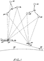
- Figure 1 illustrates a first vehicle, in this case an aircraft 20, flying above the surface of the earth 22.
- the aircraft 20 is the targeting or control aircraft.
- the aircraft 20 carries a first global positioning system (GPS) receiver 24 and a sensor 26 capable of sensing a target 28, which in this case is (but need not be) located on the earth 22.
- GPS global positioning system
- the preferred sensor 26 is a radar, most preferably a selective aperture radar (SAR).
- SAR selective aperture radar
- a second vehicle in this case a missile 30, also flies above the surface of the earth 22.
- the missile 30 carries a second GPS receiver 32, but no sensor related to the present invention.
- the missile may, but need not, have a terminal guidance sensor or the like unrelated to the present invention.
- the missile 30 is the guided vehicle in this preferred embodiment.
- the sensors could be in surface ships, submarines, torpedoes, land vehicles, etc.
- satellites 34, 36, 38, 40, 42, 44 of the GPS In orbit above the earth are a number of satellites 34, 36, 38, 40, 42, 44 of the GPS. Five of these satellites, selected as satellites 34, 36, 38, 40, and 42, are identified collectively as a "constellation" 46 herein.
- the term "constellation” is used to refer to all of the satellites which can be referenced by both the first GPS receiver and the second GPS receiver during a relevant period of time. In this example, the five satellites 34, 36, 38, 40, and 42 are available to be referenced by both GPS receivers 24 and 32. In the illustration, all five satellites are referenced by the receiver 24 in the aircraft.
- the signals of only four of the satellites 34, 36, 38, and 40 are selected by the receiver 32 in the missile 30 for referencing.
- the remaining satellite 42 of the constellation is not referenced at this particular moment for some reason, such as having an overly large bias-type error.
- some other group of four satellites from the constellation e.g., satellites 34, 38, 40, and 42
- the satellite 44 is not part of the "constellation" for the GPS receivers 24 and 32, because it is not referenced by the receiver 24 for some reason and made a part of the constellation 46.
- some smaller number of satellites--one, two, or three of the satellites of the constellation 46-- may be referenced by the receiver 32 in the missile 30.
- This use by the receiver 32 of a smaller number of satellites from the constellation 46 is less preferred, because it permits only a partial reduction in the bias-type error.
- the receiver 32 is constrained to reference only satellites from the constellation 46 for positional determinations. If other satellites not in the constellation 46 are referenced in the positional determination, the bias-errors are not eliminated.
- the aircraft 20 measures its position in the GPS frame of reference from the constellation 46 of satellites, using its GPS receiver 24.
- the operation of the GPS system is known in the art, both as to the satellites and their transmissions, and as to the receiver and its mode of operation.
- each of the satellites transmits a coded pulse at a specific moment in time.
- the receiver receives the coded pulses. From at least three, and preferably four, coded satellite pulses the receiver can determine the position of the receiver, and thence in this case the aircraft 20, relative to the satellites.
- the position of the aircraft measured by this approach will have some degree of uncertainty, as determined by noise-like errors and bias-type errors, but the sources, magnitudes, and effects of these errors will be discussed subsequently.
- the aircraft 20 also determines the position of the target 28 relative to the aircraft 20 using its sensor 26. By vectorially combining the GPS position measurement and the target position measurement, the position of the target 28 in the frame of reference of the constellation 46 is found.
- the missile 30 measures its position in the GPS frame of reference from the constellation 46 of satellites, using its GPS receiver 32. This measurement may be made at the same time as the measurement of the position of the target 28 by the aircraft 20. This measurement may also be, and preferably is, made at a later time than the measurement of the position of the target 28 by the aircraft 20. As will be discussed in greater detail subsequently, the position of the target 28 relative to the missile 30 is then readily determined from this position measurement of the missile 30. The position so determined is corrected for bias-type errors in the GPS position, negating the errors.
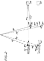
- FIG 2 is an enlarged version of part of Figure 1, illustrating the effect of GPS bias-type errors.
- the first is bias-type error.
- Bias-type error arises from such effects as uncertainty in the position of the orbits of the satellites, time-based discrepancies between the various satellite transmissions, and the effect of the atmosphere on the radio signals of the satellites. According to an analysis of the errors in the GPS measurements, bias-type error constitutes about 80-85 percent of the total uncertainty in position as a result of a measurement. Bias-type error is a systematic error that equally affects the measurements of all receivers in comparable circumstances.
- Noise-type error arises from such effects as multipath (arising as a result of reflected signals), quantization (arising as a result of roundoff errors), and receiver electrical noise. Noise-type error constitutes the remainder of the uncertainty in position measurements, about 15-20 percent of the total. Noise-type error is a random error that affects each GPS receiver differently.
- FIG 2 provides an analytical tool to understand the operation of the present invention. It should be understood, however, that Figure 2 does not depict the invention itself.
- the aircraft 20 and the missile 30 are depicted at their true locations. However, when the aircraft 20 and the missile 30 measure their positions using their GPS receivers, their apparent positions are depicted at 20' and 30'.
- the apparent position of the aircraft 20' is displaced from the true position of the aircraft 20 by the amount of its bias-type error 48.
- the bias-type error is not known by the GPS receiver or the aircraft, but can be depicted as a vector because it has an ascertainable magnitude and direction. (In the differential GPS approach discussed previously, the vector is actually determined using the true location of the reference GPS receiver, but not according to the present relative GPS approach.)
- the position of the aircraft 20 is also displaced from its true position by the amount of the noise-type error, indicated as a sphere 50.
- the position is indicated as a sphere of uncertainty because the magnitude of the error is not known precisely but a sphere can be drawn which describes a specific probability of containing the actual error.
- the apparent position of the missile 30' is displaced from the true position of the missile 20 by the amount of its bias-type vectorial error 52 and a spherically represented noise-type error 54.
- the aircraft When a position measurement is taken by the aircraft, the aircraft is at a true vectorial location A1 but an apparent vectorial location A2 relative to the GPS constellation 46, the difference being the bias-type error 46, indicated as the vector A3.
- These vectors, as here defined, satisfy the relation A1 + A3 A2. If the position of the target 28 is measured relative to the aircraft at the same time the GPS position of the aircraft is measured, the vector from the aircraft to the target is the vector AT.
- the position of the target relative to the GPS constellation 46 or, equivalently stated, in the frame of reference of the constellation 46, is A1 + AT.
- the GPS position analysis for the missile is similar to that of the aircraft.
- the missile when a position measurement is taken by the missile, the missile is at a true vectorial location M1 but an apparent vectorial location M2 relative to the GPS constellation 46, the difference being the bias-type error 52, indicated as the vector M3.
- These vectors, as here defined, satisfy the relation M1 + M3 M2.
- the vector from the missile 30 to the target at any moment is MT. This is the unknown, but here determined, true path that the missile must follow to reach the target 28.
- the position of the target relative to the GPS constellation 46 or, equivalently stated, in the frame of reference of the constellation 46, may be stated as M1 + MT.
- "(t)” indicates that the GPS position of the missile and the vector from the missile to the target are determined at some later time.
- bias-type errors for the two GPS receivers 24 and 32 are equal, then A3(0) and M3(t) are the same and cancel from the relation.
- the receivers 24 and 32 are locked to the constellation 46. This locking of the GPS signals to a single constellation is estimated to negate about 75 percent of the bias-type error.
- the bias-type error can be negated by requiring that the missile operates sufficiently close to the aircraft that changes in atmospheric effects and deviations in line-of-sight angles to the satellites are negligible. While these factors vary with separation between the missile and the aircraft, calculations have shown that the total bias-type error can be held to less than about 5 feet if the separation between the missile and the aircraft is less than about 150 miles. Even at distances of 250 miles separation, the bias-type error is less than about 10 feet.
- the important result is that the bias-type errors are eliminated in large part by forcing the GPS receivers 24 and 32 to conduct their measurements from the same constellation 46 of GPS satellites, and further by keeping the missile sufficiently close to the aircraft for the entire mission.
- the missile 30 may be launched from the aircraft 20, but need not be launched from the aircraft 20.
- the targeting aircraft 20 can be another aircraft, such as an aircraft flying at very high altitudes or a controller or AWACS aircraft.
- the targeting aircraft 20 must operate under the conditions discussed here, however. Nevertheless, the present approach permits the missile to be delivered to near its target by a stealthy aircraft, which need never acquire the target with a sensor and thereby reveal its location.
- the targeting aircraft need not continuously acquire or illuminate the target--a single relative targeting measurement is sufficient.
- a stand-off range for the targeting aircraft from the target of 150 miles is sufficient, and permits the missile to be placed to within about 5 feet of the desired target location using only GPS navigational measurements.
- the missile carries no sensor in this embodiment.
- the missile may carry a relatively unsophisticated terminal guidance sensor that guides it to the target in the terminal phase of the attack, after being guided to nearly the correct location by the GPS approach discussed here.
Landscapes
- Engineering & Computer Science (AREA)
- Radar, Positioning & Navigation (AREA)
- Remote Sensing (AREA)
- Chemical & Material Sciences (AREA)
- Combustion & Propulsion (AREA)
- General Engineering & Computer Science (AREA)
- Position Fixing By Use Of Radio Waves (AREA)
- Aiming, Guidance, Guns With A Light Source, Armor, Camouflage, And Targets (AREA)
Applications Claiming Priority (2)
| Application Number | Priority Date | Filing Date | Title |
|---|---|---|---|
| US947623 | 1992-09-21 | ||
| US07/947,623 US5344105A (en) | 1992-09-21 | 1992-09-21 | Relative guidance using the global positioning system |
Publications (1)
| Publication Number | Publication Date |
|---|---|
| EP0589645A1 true EP0589645A1 (fr) | 1994-03-30 |
Family
ID=25486444
Family Applications (1)
| Application Number | Title | Priority Date | Filing Date |
|---|---|---|---|
| EP93307391A Withdrawn EP0589645A1 (fr) | 1992-09-21 | 1993-09-20 | Guidage relatif utilisant le GPS |
Country Status (4)
| Country | Link |
|---|---|
| US (1) | US5344105A (fr) |
| EP (1) | EP0589645A1 (fr) |
| JP (1) | JP2625360B2 (fr) |
| IL (1) | IL106982A (fr) |
Cited By (4)
| Publication number | Priority date | Publication date | Assignee | Title |
|---|---|---|---|---|
| WO1996025641A3 (fr) * | 1995-02-14 | 1996-09-26 | Bofors Ab | Procede et dispositif permettant une correction de trajectoire pour poussee radiale pour un projectile ballistique |
| EP0747657A3 (fr) * | 1995-06-05 | 1998-12-02 | Raytheon Company | Système de guidage d'armes à auto-contrÔle utilisant des signaux SGP (Système de Positionnement Global) |
| GB2402825A (en) * | 2003-06-12 | 2004-12-15 | Anthony Michael O'doherty | Competitor monitor |
| CN106019348A (zh) * | 2015-08-25 | 2016-10-12 | 中国运载火箭技术研究院 | 一种基于多滞空平台组网的高精度定位装置及方法 |
Families Citing this family (54)
| Publication number | Priority date | Publication date | Assignee | Title |
|---|---|---|---|---|
| US5424742A (en) * | 1992-12-31 | 1995-06-13 | Raytheon Company | Synthetic aperture radar guidance system and method of operating same |
| US5983161A (en) | 1993-08-11 | 1999-11-09 | Lemelson; Jerome H. | GPS vehicle collision avoidance warning and control system and method |
| US5657947A (en) * | 1994-08-24 | 1997-08-19 | Loral Corp. | Precision guidance system for aircraft launched bombs |
| US5481904A (en) * | 1994-09-28 | 1996-01-09 | The United States Of America As Represented By The Secretary Of The Navy | Oil spillage detector |
| US5702070A (en) * | 1995-09-20 | 1997-12-30 | E-Systems, Inc. | Apparatus and method using relative GPS positioning for aircraft precision approach and landing |
| US5748136A (en) * | 1995-09-22 | 1998-05-05 | Rockwell International Corporation | Electronic landmark enhancement to GPS based navigation systems |
| US5713293A (en) * | 1995-09-22 | 1998-02-03 | The United States Of America As Represented By The Secretary Of The Navy | Unmanned sea surface vehicle having a personal watercraft hull form |
| US5774826A (en) * | 1995-11-30 | 1998-06-30 | Trimble Navigation Limited | Optimization of survey coordinate transformations |
| US5987979A (en) * | 1996-04-01 | 1999-11-23 | Cairo Systems, Inc. | Method and apparatus for detecting railtrack failures by comparing data from a plurality of railcars |
| US5786773A (en) * | 1996-10-02 | 1998-07-28 | The Boeing Company | Local-area augmentation system for satellite navigation precision-approach system |
| US6237496B1 (en) | 1997-02-26 | 2001-05-29 | Northrop Grumman Corporation | GPS guided munition |
| US5943009A (en) * | 1997-02-27 | 1999-08-24 | Abbott; Anthony Steven | GPS guided munition |
| US6043777A (en) * | 1997-06-10 | 2000-03-28 | Raytheon Aircraft Company | Method and apparatus for global positioning system based cooperative location system |
| US6142411A (en) * | 1997-06-26 | 2000-11-07 | Cobleigh; Nelson E. | Geographically limited missile |
| US5954612A (en) * | 1997-08-18 | 1999-09-21 | Dana Corporation | Multi-speed offset transfer case |
| JPH11287850A (ja) * | 1998-04-03 | 1999-10-19 | Sony Corp | 測位システム、測位装置および測位方法 |
| FR2780154B1 (fr) * | 1998-06-19 | 2001-01-05 | Dassault Electronique | Engin volant guide avec radionavigation gps et telecommande associee |
| US6293202B1 (en) * | 1998-08-17 | 2001-09-25 | The United States Of America As Represented By The Secretary Of The Navy | Precision, airborne deployed, GPS guided standoff torpedo |
| US6166679A (en) * | 1999-01-13 | 2000-12-26 | Lemelson Jerome H. | Friend or foe detection system and method and expert system military action advisory system and method |
| IL135449A (en) | 2000-04-04 | 2003-04-10 | Frucht Yaacov | Method and system for guiding submunitions |
| RU2192603C2 (ru) * | 2000-07-04 | 2002-11-10 | Общевойсковая Академия Вооруженных Сил Российской Федерации | Способ наведения управляемой ракеты |
| JP2002162195A (ja) * | 2000-11-21 | 2002-06-07 | Toshiba Corp | 飛翔体誘導装置 |
| US6414629B1 (en) | 2001-04-19 | 2002-07-02 | Tektrack, Llc | Tracking device |
| RU2213318C1 (ru) * | 2002-05-13 | 2003-09-27 | Общевойсковая Академия Вооруженных Сил Российской Федерации | Способ наведения управляемой ракеты |
| RU2213926C1 (ru) * | 2002-05-29 | 2003-10-10 | Общевойсковая Академия Вооруженных Сил Российской Федерации | Способ наведения управляемой ракеты |
| EP1570289A4 (fr) * | 2002-11-15 | 2008-01-23 | Lockheed Corp | Systeme de navigation et de guidage de precision tous temps |
| US6940451B2 (en) * | 2003-02-19 | 2005-09-06 | Nokia Corporation | Provision of navigation information |
| US8639416B2 (en) | 2003-03-20 | 2014-01-28 | Agjunction Llc | GNSS guidance and machine control |
| US8140223B2 (en) * | 2003-03-20 | 2012-03-20 | Hemisphere Gps Llc | Multiple-antenna GNSS control system and method |
| US8634993B2 (en) | 2003-03-20 | 2014-01-21 | Agjunction Llc | GNSS based control for dispensing material from vehicle |
| US9002565B2 (en) | 2003-03-20 | 2015-04-07 | Agjunction Llc | GNSS and optical guidance and machine control |
| FR2855258B1 (fr) * | 2003-05-19 | 2006-06-30 | Giat Ind Sa | Procede de controle de la trajectoire d'un projectile girant |
| US6830213B1 (en) * | 2003-05-21 | 2004-12-14 | Lucent Technologies Inc. | Wireless guidance system |
| US20060071849A1 (en) * | 2004-09-30 | 2006-04-06 | Lockheed Martin Corporation | Tactical all weather precision guidance and navigation system |
| US7338009B1 (en) * | 2004-10-01 | 2008-03-04 | The United States Of America As Represented By The Secretary Of The Navy | Apparatus and method for cooperative multi target tracking and interception |
| US7947936B1 (en) * | 2004-10-01 | 2011-05-24 | The United States Of America As Represented By The Secretary Of The Navy | Apparatus and method for cooperative multi target tracking and interception |
| US7121502B2 (en) * | 2005-01-26 | 2006-10-17 | Raytheon Company | Pseudo GPS aided multiple projectile bistatic guidance |
| SE529504C2 (sv) * | 2005-05-25 | 2007-08-28 | Bae Systems Bofors Ab | System, förfarande, anordning, användning av anordning samt datorprogramprodukt för invisning av mål |
| US7453395B2 (en) * | 2005-06-10 | 2008-11-18 | Honeywell International Inc. | Methods and systems using relative sensing to locate targets |
| US7728264B2 (en) * | 2005-10-05 | 2010-06-01 | Raytheon Company | Precision targeting |
| RU2334936C1 (ru) * | 2007-02-20 | 2008-09-27 | Общевойсковая Академия Вооруженных Сил Российской Федерации (Оа Вс Рф) | Способ наведения управляемой ракеты |
| US20090002677A1 (en) * | 2007-06-26 | 2009-01-01 | Honeywell International Inc. | Target locator system |
| US7631833B1 (en) * | 2007-08-03 | 2009-12-15 | The United States Of America As Represented By The Secretary Of The Navy | Smart counter asymmetric threat micromunition with autonomous target selection and homing |
| US8174433B1 (en) | 2009-02-26 | 2012-05-08 | Raytheon Company | Bias estimation and orbit determination |
| US8076622B1 (en) * | 2009-08-31 | 2011-12-13 | Rockwell Collins, Inc. | Low profile, conformal global positioning system array for artillery |
| RU2393415C1 (ru) * | 2009-11-06 | 2010-06-27 | Дамир Фазрахманович Зиганшин | Способ наведения управляемой ракеты |
| RU2426055C1 (ru) * | 2010-03-19 | 2011-08-10 | Бассам Ахмед Дииб | Способ наведения управляемой ракеты |
| US9410783B1 (en) * | 2010-05-05 | 2016-08-09 | The United States Of America As Represented By The Secretary Of The Army | Universal smart fuze for unmanned aerial vehicle or other remote armament systems |
| US8362943B2 (en) * | 2010-07-02 | 2013-01-29 | Northrop Grumman Guidance And Electronics Company, Inc. | Radar registration using targets of opportunity |
| US8610041B1 (en) * | 2011-05-23 | 2013-12-17 | Lockheed Martin Corporation | Missile tracking by GPS reflections |
| US8829401B1 (en) * | 2011-06-16 | 2014-09-09 | The Boeing Company | Projectile and associated method for seeking a target identified by laser designation |
| US8939056B1 (en) * | 2012-04-20 | 2015-01-27 | Barron Associates, Inc. | Systems, devices, and/or methods for managing targeted payload descent |
| JP2013156011A (ja) * | 2013-02-28 | 2013-08-15 | Ihi Aerospace Co Ltd | レーザセミアクティブ誘導方法 |
| CN116817895A (zh) * | 2022-03-22 | 2023-09-29 | 北京恒星箭翔科技有限公司 | 一种含有制导仪的卫星制导系统及制导方法 |
Citations (3)
| Publication number | Priority date | Publication date | Assignee | Title |
|---|---|---|---|---|
| US4741245A (en) * | 1986-10-03 | 1988-05-03 | Dkm Enterprises | Method and apparatus for aiming artillery with GPS NAVSTAR |
| DE3932548A1 (de) * | 1989-09-29 | 1991-04-11 | Telefunken Systemtechnik | Verfahren und vorrichtung fuer eine torpedozielsteuerung |
| EP0547637A1 (fr) * | 1991-12-19 | 1993-06-23 | Hughes Aircraft Company | Guidage d'arme de précision autonome utilisant un radar à ouverture synthétique |
Family Cites Families (2)
| Publication number | Priority date | Publication date | Assignee | Title |
|---|---|---|---|---|
| US4949089A (en) * | 1989-08-24 | 1990-08-14 | General Dynamics Corporation | Portable target locator system |
| US5131602A (en) * | 1990-06-13 | 1992-07-21 | Linick James M | Apparatus and method for remote guidance of cannon-launched projectiles |
-
1992
- 1992-09-21 US US07/947,623 patent/US5344105A/en not_active Expired - Lifetime
-
1993
- 1993-09-10 IL IL106982A patent/IL106982A/en unknown
- 1993-09-20 EP EP93307391A patent/EP0589645A1/fr not_active Withdrawn
- 1993-09-21 JP JP5235014A patent/JP2625360B2/ja not_active Expired - Lifetime
Patent Citations (3)
| Publication number | Priority date | Publication date | Assignee | Title |
|---|---|---|---|---|
| US4741245A (en) * | 1986-10-03 | 1988-05-03 | Dkm Enterprises | Method and apparatus for aiming artillery with GPS NAVSTAR |
| DE3932548A1 (de) * | 1989-09-29 | 1991-04-11 | Telefunken Systemtechnik | Verfahren und vorrichtung fuer eine torpedozielsteuerung |
| EP0547637A1 (fr) * | 1991-12-19 | 1993-06-23 | Hughes Aircraft Company | Guidage d'arme de précision autonome utilisant un radar à ouverture synthétique |
Non-Patent Citations (3)
| Title |
|---|
| GREG HYSLOP , DENNIS GERTH AND JOHN KRAEMER: "GPS / INS Integration on the Stanfoff Land Attack Missile ( SLAM )", IEEE PLANS 90 IEEE AES, vol. 5, no. 7, July 1990 (1990-07-01), NEW YORK , NY , USA, pages 29 - 34 * |
| M. K. DOSH: "GPS Weapon Delivery", IEEE NTC 83 IEEE, November 1983 (1983-11-01), SAN FRANCISCO , CA , USA, pages 123 - 9 * |
| R. W. BLANK AND W. D. RHODES JR.: "Field test results prove GPS performance utility", IEEE PLANS 86 IEEE, November 1986 (1986-11-01), LAS VEGAS , NV , USA, pages 287 - 96 * |
Cited By (5)
| Publication number | Priority date | Publication date | Assignee | Title |
|---|---|---|---|---|
| WO1996025641A3 (fr) * | 1995-02-14 | 1996-09-26 | Bofors Ab | Procede et dispositif permettant une correction de trajectoire pour poussee radiale pour un projectile ballistique |
| EP0747657A3 (fr) * | 1995-06-05 | 1998-12-02 | Raytheon Company | Système de guidage d'armes à auto-contrÔle utilisant des signaux SGP (Système de Positionnement Global) |
| GB2402825A (en) * | 2003-06-12 | 2004-12-15 | Anthony Michael O'doherty | Competitor monitor |
| GB2402825B (en) * | 2003-06-12 | 2007-02-14 | Anthony Michael O'doherty | Monitoring system and method |
| CN106019348A (zh) * | 2015-08-25 | 2016-10-12 | 中国运载火箭技术研究院 | 一种基于多滞空平台组网的高精度定位装置及方法 |
Also Published As
| Publication number | Publication date |
|---|---|
| JP2625360B2 (ja) | 1997-07-02 |
| JPH06221795A (ja) | 1994-08-12 |
| US5344105A (en) | 1994-09-06 |
| IL106982A (en) | 1998-02-22 |
| IL106982A0 (en) | 1994-01-25 |
Similar Documents
| Publication | Publication Date | Title |
|---|---|---|
| US5344105A (en) | Relative guidance using the global positioning system | |
| EP0547637B1 (fr) | Guidage d'arme de précision autonome utilisant un radar à ouverture synthétique | |
| US5969676A (en) | Radio frequency interferometer and laser rangefinder/destination base targeting system | |
| US6512976B1 (en) | Method and system for terrain aided navigation | |
| US6839017B1 (en) | Method and apparatus for using anti-jam technology to determine the location of an electromagnetic radiation source | |
| EP0747657B1 (fr) | Système de guidage d'armes à auto-contrôle utilisant des signaux SGP (Système de Positionnement Global) | |
| US5943009A (en) | GPS guided munition | |
| US8093539B2 (en) | Integrated reference source and target designator system for high-precision guidance of guided munitions | |
| US8076621B2 (en) | Integrated reference source and target designator system for high-precision guidance of guided munitions | |
| US8637798B2 (en) | Integrated reference source and target designator system for high-precision guidance of guided munitions | |
| EP0583972A1 (fr) | Améliorations concernant le ciblage de précision | |
| US6142412A (en) | Highly accurate long range optically-aided inertially guided type missile | |
| Wiederholt et al. | Phase III GPS integration options for aircraft platforms | |
| AU748654B2 (en) | GPS guided munition | |
| AU748028B2 (en) | GPS guided munition | |
| Buell et al. | The AN/ASN‐128B: An Integrated Doppler/GPS Navigation System for Helicopters | |
| Ioannidis et al. | GPS exploitation for precision targeting a relative targeting system | |
| NIEMELA | REPRESENTATIVE VEHICLE IMPLEMENTATION JOHN NIEMELA US ARMY COMMUNICATION-ELECTRONICS COMMAND RESEARCH & DEVELOPMENT CENTER FORT MONMOUTH, NJ | |
| Urban | The Impact of Global Positioning System on Guidance and Controls Systems Design of Military Aircraft. Volume IIA. Specific Application Study No. 1. Application of the NAVSTAR/Global Positioning System to the Close Air Support Mission-A Case Study | |
| Dargan | Autonomous Weapon Guidance |
Legal Events
| Date | Code | Title | Description |
|---|---|---|---|
| PUAI | Public reference made under article 153(3) epc to a published international application that has entered the european phase |
Free format text: ORIGINAL CODE: 0009012 |
|
| AK | Designated contracting states |
Kind code of ref document: A1 Designated state(s): DE ES FR GB SE |
|
| 17P | Request for examination filed |
Effective date: 19940901 |
|
| 17Q | First examination report despatched |
Effective date: 19951228 |
|
| STAA | Information on the status of an ep patent application or granted ep patent |
Free format text: STATUS: THE APPLICATION IS DEEMED TO BE WITHDRAWN |
|
| 18D | Application deemed to be withdrawn |
Effective date: 19960508 |