EP0683401A2 - Dispositif de localisation - Google Patents
Dispositif de localisation Download PDFInfo
- Publication number
- EP0683401A2 EP0683401A2 EP95302493A EP95302493A EP0683401A2 EP 0683401 A2 EP0683401 A2 EP 0683401A2 EP 95302493 A EP95302493 A EP 95302493A EP 95302493 A EP95302493 A EP 95302493A EP 0683401 A2 EP0683401 A2 EP 0683401A2
- Authority
- EP
- European Patent Office
- Prior art keywords
- data
- locating device
- cable
- locating
- receiving
- Prior art date
- Legal status (The legal status is an assumption and is not a legal conclusion. Google has not performed a legal analysis and makes no representation as to the accuracy of the status listed.)
- Granted
Links
Images
Classifications
-
- G—PHYSICS
- G01—MEASURING; TESTING
- G01V—GEOPHYSICS; GRAVITATIONAL MEASUREMENTS; DETECTING MASSES OR OBJECTS; TAGS
- G01V3/00—Electric or magnetic prospecting or detecting; Measuring magnetic field characteristics of the earth, e.g. declination, deviation
- G01V3/15—Electric or magnetic prospecting or detecting; Measuring magnetic field characteristics of the earth, e.g. declination, deviation specially adapted for use during transport, e.g. by a person, vehicle or boat
Definitions
- the present invention relates to a locating device and in particular to a locating device for locating an underground object such as a cable or pipe.
- locating devices e.g. for underground cables
- One such device produced by the applicants, detects a magnetic field produced by an electric current in an underground cable using a pair of detector coils. The device gives an indication of when the user is directly above a portion of the buried underground cable. Typically, the user then marks the position of the cable on the ground surface and then moves along the cable detecting further portions of it. Thus the position of the length of cable can be determined.
- the present invention aims to reduce the complexity of recording the location of an underground object, such as a cable, and to increase the ease with which the object can be re-located.
- the present invention provides a locating device including underground object locating means; positional data receiving means for receiving data relating to the geographical position of the locating device; and data storage means for storing data relating to the position of the locating device when an underground object is located, as determined by the geographical position of the locating device.
- the geographical positional data is stored relating to the location of the underground cable, and may be subsequently retrieved for re-location of the cable.
- the data storage means may store data relating to the position of the underground object itself.
- the recordal of the geographical positional data of the underground cable may be permanent, and is not reliant on physical landmarks, e.g. roads etc., nor on the accuracy of a particular mapping system used. Furthermore, there is no need to physically mark the location of the underground cable on the ground surface in order to survey it for mapping, which is necessary even where digital mapping systems are employed.
- GPS geo-positional satellites
- a system utilising such satellite data is sometimes referred to as a Global Positioning System, and the same abbreviation GPS used.
- Each satellite contains four atomic clocks and broadcasts time data and other information identifying itself and describing its path.
- a GPS receiver compares the signals with its own clock(s) and then determines its location in terms of latitude and longitude by calculating the distance between it and the satellites.
- data may be obtained from 3 or 4 of the satellites and trigonometrical calculations performed to determine the position of the receiver.
- the typical accuracy obtainable using a commercially available receiver is between 20 - 100 metres for this simple system.
- the accuracy of the system can be improved by adding data from a second, stationary, receiver and readings can then be refined to within a few centimetres.
- the positional data receiving means include means for receiving GPS data.
- the positional data receiving means need not be physically located within the body of the locating device - the GPS receiver, for example, could be connected to a datalogger which in turn is connected e.g. via an interface (such as an RS232 interface) to the locating device.
- the locating device could be adapted to accept a PC memory card type GPS receiver.
- the positional data receiving means receives data from both overhead GPS satellite(s) and a second stationary (differential) receiver, thus improving the accuracy of the geographical location measurement.
- the data from the differential receiver may be received, for example, by radio transmission such as an FM link, or may be transmitted to the locating device via a fibre optic cable sheath. If an FM link is being used, the differential information may be received by the operator via a "beeper" type device, with the beeper being hard wired to the GPS receiver.
- the ⁇ beeper'' type device may be a radio receiver which then passes the differential information to the GPS receiver.
- the differential information may be provided by a plurality of land-based receivers - for example in the USA a network of around 300 FM stations provides the differential signal.
- a land station may be up to, for example, 200 miles away and still transmit receivable differential data.
- the locating device is of the type which detects a magnetic field produced by a current passing through an underground cable.
- the underground object locating means may therefore include magnetic field detection means, such as a pair of detecting coils.
- the differential data may be modulated on to the signal which is passed through the cable.
- the locating device may then receive the data from the signal in the cable, for example using the two detection coils, thus removing the need for FM reception of the differential data. Since the rate of update of the GPS information is relatively slow, the typical modulation of the data on the cable may be low e.g. 10-20Hz.
- the differential data may be transmitted along the line.
- the differential data may be input on to the cable at a repeater station.
- the position of cable joints may be recorded using this system together with a datalogger.
- the positional data and/or any other data may be recorded in a buried RF identity marker.
- a marker designed to be interrogated by a suitable transmitter/receiver, would be programmed with the longitude/latitude information, and then be buried above or near the target line cable; this data could also be recorded on a map of the target area (such maps being commonly called 'asbuilts' by A.T.&T and others). The map could then be used to point the operator to the area in which the market tag should be found next time location is required.
- the present invention relates to a locating device including positional data receiving means for receiving data relating to the geographical position of the locating device; data storage means containing data relating to the location of an underground object; means for comparing the data stored in the data storage means with the data received by the positional data receiving means; and means for producing a warning signal when said means for comparing indicate that the underground object is within a predetermined distance of the locating device.
- the data relating to the location of the underground cable may be stored in a "beeper" type device, which device is also capable of receiving GPS data and comparing the received GPS data with the stored cable location data and producing an appropriate output when the' two sufficiently coincide.
- Such a device could, for example, be carried by workmen in order to prevent inadvertent interference with a given underground cable.
- the present invention also relates to a method of recording the position of a underground object, including the steps of:
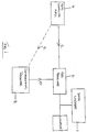
- GPS information 2 is produced by one or more GPS satellites 4.
- the positional information 2 is transmitted to a GPS receiver 6 and a differential receiver 8.
- the differential receiver 8 in turn transmits differential information 10 to the GPS receiver 6.
- the differential information 10 may be transmitted, for example, via an FM link, along a fibre optic cable sheath or by modulating an electrical signal along the cable to be located/logged.
- the GPS receiver 6 transmits information to a data-logger 12.
- the data logger 12 also receives information from a locating device 14 which is used to locate, for example, an underground cable.
- the GPS receiver 6 and/or the datalogger 12 may be incorporated in the locator 14 or alternatively either or both of them may be external to the locator 14.
- the data logger 12 records information relating to the detection (or otherwise) of the underground cable and to the geographical location of the locating device. The location of the underground cable may then be recorded.
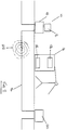
- Fig 2 shows a schematic diagram of a locating device (not to scale) 14 being used to locate an underground cable 16.
- the underground cable for example a telephone cable, includes repeater stations 18, 20 to amplify the data signal as it passes along the cable 16.
- the cable is located by introducing a signal, for example at a repeater station, on to the cable and detecting the magnetic field 22 produced by the signal on the cable.
- the signal introduced on to the cable for this purpose may be, e.g. between 5Hz and 100KHz and is typically around 500Hz.
- Two detecting coils 24, 26 in the locating device 14 are used to detect the magnetic field 22.
- the locator 14 includes a GPS receiver 6 for reception of GPS positional data.
- Differential data 10 is input on to the cable using a differential receiver 8 at the repeater station 18.
- the differential data 10 may be modulated on to the cable signal, for example at a modulation frequency of 10 - 20Hz.
- This differential data is received by the locater 14 using the reception means such as the detection coils 24, 26.
- differential data could be received by the GPS receiver by means other than an FM link or signal modulation.
- GPS receiver could be located remote from the locater and/or data logger and the positional data transmitted to the data logger via other conventional transmission methods.
Landscapes
- Life Sciences & Earth Sciences (AREA)
- Engineering & Computer Science (AREA)
- Environmental & Geological Engineering (AREA)
- Geology (AREA)
- Remote Sensing (AREA)
- Physics & Mathematics (AREA)
- General Life Sciences & Earth Sciences (AREA)
- General Physics & Mathematics (AREA)
- Geophysics (AREA)
- Position Fixing By Use Of Radio Waves (AREA)
- Geophysics And Detection Of Objects (AREA)
- Navigation (AREA)
Priority Applications (1)
| Application Number | Priority Date | Filing Date | Title |
|---|---|---|---|
| EP03075551A EP1321779B1 (fr) | 1994-04-18 | 1995-04-13 | Dispositif de localisation |
Applications Claiming Priority (2)
| Application Number | Priority Date | Filing Date | Title |
|---|---|---|---|
| US228686 | 1994-04-18 | ||
| US08/228,686 US5576973A (en) | 1994-04-18 | 1994-04-18 | Apparatus and method for obtaining geographical positional data for an object located underground |
Related Child Applications (1)
| Application Number | Title | Priority Date | Filing Date |
|---|---|---|---|
| EP03075551A Division EP1321779B1 (fr) | 1994-04-18 | 1995-04-13 | Dispositif de localisation |
Publications (3)
| Publication Number | Publication Date |
|---|---|
| EP0683401A2 true EP0683401A2 (fr) | 1995-11-22 |
| EP0683401A3 EP0683401A3 (fr) | 1997-09-10 |
| EP0683401B1 EP0683401B1 (fr) | 2003-12-17 |
Family
ID=22858191
Family Applications (2)
| Application Number | Title | Priority Date | Filing Date |
|---|---|---|---|
| EP03075551A Expired - Lifetime EP1321779B1 (fr) | 1994-04-18 | 1995-04-13 | Dispositif de localisation |
| EP95302493A Expired - Lifetime EP0683401B1 (fr) | 1994-04-18 | 1995-04-13 | Dispositif de localisation |
Family Applications Before (1)
| Application Number | Title | Priority Date | Filing Date |
|---|---|---|---|
| EP03075551A Expired - Lifetime EP1321779B1 (fr) | 1994-04-18 | 1995-04-13 | Dispositif de localisation |
Country Status (3)
| Country | Link |
|---|---|
| US (1) | US5576973A (fr) |
| EP (2) | EP1321779B1 (fr) |
| DE (2) | DE69536055D1 (fr) |
Cited By (13)
| Publication number | Priority date | Publication date | Assignee | Title |
|---|---|---|---|---|
| EP0798570A3 (fr) * | 1996-03-25 | 1999-04-28 | Vallon GmbH | Procédé et dispositif de mesure pour localiser des objets dans la terre |
| EP0866344A3 (fr) * | 1997-03-22 | 2001-05-23 | STN ATLAS Elektronik GmbH | Procédé et dispositif pour détecter et/ou enlever de mitraille de métal |
| EP0989353A3 (fr) * | 1998-09-23 | 2001-08-16 | Pipeline Integrity International, Inc. | Systeme de cartographie pour l'integration et l'affichage graphique de l'information du conduit pour surveillance automatique de conduites |
| EP1148351A1 (fr) * | 2000-04-20 | 2001-10-24 | Wolfgang Rösler | Méthode et appareil pour déterminer la susceptibilité des sols et/ou des sédiments |
| EP1229345A3 (fr) * | 2001-01-23 | 2003-12-03 | Ruhrgas Aktiengesellschaft | Système pour localisation de véhicules de chantier ou de dispositifs d'engins de terrassement |
| GB2405278A (en) * | 2003-07-30 | 2005-02-23 | Varco Int | Precision positioning system for monitoring pipeline pig |
| WO2006014724A3 (fr) * | 2004-07-20 | 2006-04-06 | Global Prec Solutions Llp | Gestion de ressources utilitaires commandees par un systeme mondial de localisation de precision et de prevention de dommages |
| US8081112B2 (en) | 2004-07-20 | 2011-12-20 | Global Precision Solutions, Llp. | System and method for collecting information related to utility assets |
| WO2010093426A3 (fr) * | 2009-02-11 | 2012-01-05 | Certusview Technologies, Llc | Appareil de localisation équipé de caractéristiques améliorées pour des opérations de localisation d'équipements souterrains, et procédé et systèmes associés |
| GB2477059B (en) * | 2008-10-02 | 2012-10-17 | Certusview Technologies Llc | Methods, apparatus, and systems for generating electronic records of locate and marking operations, and combined locate and marking apparatus for same |
| GB2477061B (en) * | 2008-10-02 | 2012-10-17 | Certusview Technologies Llc | Methods and apparatus for generating electronic records of locate operations |
| US9185176B2 (en) | 2009-02-11 | 2015-11-10 | Certusview Technologies, Llc | Methods and apparatus for managing locate and/or marking operations |
| CN108535751A (zh) * | 2018-03-06 | 2018-09-14 | 上海瑞洋船舶科技有限公司 | 水下定位装置及定位方法 |
Families Citing this family (77)
| Publication number | Priority date | Publication date | Assignee | Title |
|---|---|---|---|---|
| US5553407A (en) * | 1995-06-19 | 1996-09-10 | Vermeer Manufacturing Company | Excavator data acquisition and control system and method of use |
| DE19645528A1 (de) * | 1996-11-05 | 1998-05-07 | Nfs Navigations Und Flugfuehru | Satelliten-Navigationsverfahren |
| DE19652977C1 (de) * | 1996-12-19 | 1998-04-30 | Vallon Gmbh | Ortungseinrichtung für im Erdbereich befindliche Objekte |
| US5967079A (en) * | 1998-02-26 | 1999-10-19 | At&T Corp. | Surface marking device and method |
| US5949373A (en) * | 1998-06-03 | 1999-09-07 | At & T Corp | Automated cable installation method and apparatus |
| US6285320B1 (en) | 1999-09-03 | 2001-09-04 | Sikorsky Aircraft Corporation | Apparatus and method for mapping surfaces of an object |
| US6332738B1 (en) * | 2000-03-06 | 2001-12-25 | At&T Corp. | Fiber optic cable installation method and apparatus |
| US6999021B2 (en) * | 2001-03-12 | 2006-02-14 | Ensco, Inc. | Method and apparatus for detecting, mapping and locating underground utilities |
| US6650293B1 (en) * | 2001-10-22 | 2003-11-18 | At&T Corp. | Technique for providing conveyance locating information |
| US6825793B2 (en) | 2002-03-01 | 2004-11-30 | Ensco, Inc. | System and method for detecting and locating underground objects |
| KR100888499B1 (ko) * | 2002-05-28 | 2009-03-12 | 주식회사 케이티 | 지하 시설물의 위치 탐지장치 |
| US6748340B2 (en) * | 2002-09-20 | 2004-06-08 | Ntt Infrastructure Network Corporation | Cable position information management system, facility information management system, cable core wire management system, and methods and programs thereof |
| US7372247B1 (en) | 2003-04-03 | 2008-05-13 | Tri-Site, Inc. | Apparatus and method for locating and marking an underground utility |
| US7120564B2 (en) * | 2003-04-03 | 2006-10-10 | Metrotech Corporation | Buried line locator with integral position sensing |
| JP3746283B2 (ja) * | 2003-09-22 | 2006-02-15 | エヌ・ティ・ティ・インフラネット株式会社 | 連続ケーブル位置探査装置、連続ケーブル位置探査方法、及び連続ケーブル位置探査プログラム |
| US7319387B2 (en) * | 2004-03-17 | 2008-01-15 | 3M Innovaative Properties Company | GPS interface for locating device |
| CA2548926C (fr) * | 2006-05-10 | 2012-12-04 | Shamus Mcdonnell | Methode d'acquisition de donnees pendant le lever de conducteurs lineaires enfouis |
| IL180334A (en) * | 2006-12-26 | 2014-03-31 | Elta Systems Ltd | A method and system for monitoring underground electrical cables |
| NL1033485C2 (nl) * | 2007-03-05 | 2008-09-17 | Volkerwessels Intellectuele Eigendom Bv | Werkwijze, inrichting en systeem voor het identificeren van een object dat onderdeel uitmaakt van een ondergrondse infrastructuur. |
| US8700325B2 (en) | 2007-03-13 | 2014-04-15 | Certusview Technologies, Llc | Marking apparatus and methods for creating an electronic record of marking operations |
| US8060304B2 (en) | 2007-04-04 | 2011-11-15 | Certusview Technologies, Llc | Marking system and method |
| US8473209B2 (en) * | 2007-03-13 | 2013-06-25 | Certusview Technologies, Llc | Marking apparatus and marking methods using marking dispenser with machine-readable ID mechanism |
| US7640105B2 (en) | 2007-03-13 | 2009-12-29 | Certus View Technologies, LLC | Marking system and method with location and/or time tracking |
| US8046169B2 (en) * | 2008-01-03 | 2011-10-25 | Andrew, Llc | System and method for determining the geographic location of a device |
| CA2707246C (fr) | 2009-07-07 | 2015-12-29 | Certusview Technologies, Llc | Evaluation automatique d'une productivite ou d'une competence d'un technicien de localisation en ce qui a trait a une operation de localisation et de marquage |
| US8532342B2 (en) | 2008-02-12 | 2013-09-10 | Certusview Technologies, Llc | Electronic manifest of underground facility locate marks |
| US8672225B2 (en) | 2012-01-31 | 2014-03-18 | Ncr Corporation | Convertible barcode reader |
| US8290204B2 (en) | 2008-02-12 | 2012-10-16 | Certusview Technologies, Llc | Searchable electronic records of underground facility locate marking operations |
| US20090240554A1 (en) * | 2008-03-24 | 2009-09-24 | Pinpoint Geotech, Llc | System and method for providing identification and location information of certain items |
| US8612271B2 (en) | 2008-10-02 | 2013-12-17 | Certusview Technologies, Llc | Methods and apparatus for analyzing locate and marking operations with respect to environmental landmarks |
| US8280631B2 (en) | 2008-10-02 | 2012-10-02 | Certusview Technologies, Llc | Methods and apparatus for generating an electronic record of a marking operation based on marking device actuations |
| US8965700B2 (en) | 2008-10-02 | 2015-02-24 | Certusview Technologies, Llc | Methods and apparatus for generating an electronic record of environmental landmarks based on marking device actuations |
| US9208458B2 (en) | 2008-10-02 | 2015-12-08 | Certusview Technologies, Llc | Methods and apparatus for analyzing locate and marking operations with respect to facilities maps |
| US8620587B2 (en) | 2008-10-02 | 2013-12-31 | Certusview Technologies, Llc | Methods, apparatus, and systems for generating electronic records of locate and marking operations, and combined locate and marking apparatus for same |
| US8424486B2 (en) | 2008-07-10 | 2013-04-23 | Certusview Technologies, Llc | Marker detection mechanisms for use in marking devices and methods of using same |
| US20100188088A1 (en) * | 2008-10-02 | 2010-07-29 | Certusview Technologies, Llc | Methods and apparatus for displaying and processing facilities map information and/or other image information on a locate device |
| US20100198663A1 (en) * | 2008-10-02 | 2010-08-05 | Certusview Technologies, Llc | Methods and apparatus for overlaying electronic marking information on facilities map information and/or other image information displayed on a marking device |
| US8478617B2 (en) | 2008-10-02 | 2013-07-02 | Certusview Technologies, Llc | Methods and apparatus for generating alerts on a locate device, based on comparing electronic locate information to facilities map information and/or other image information |
| US8442766B2 (en) | 2008-10-02 | 2013-05-14 | Certusview Technologies, Llc | Marking apparatus having enhanced features for underground facility marking operations, and associated methods and systems |
| US8749239B2 (en) | 2008-10-02 | 2014-06-10 | Certusview Technologies, Llc | Locate apparatus having enhanced features for underground facility locate operations, and associated methods and systems |
| CA2691707C (fr) | 2009-02-11 | 2013-09-24 | Certusview Technologies, Llc | Appareil de marquage comportant des fonctions ameliorees pour operations de marquage d'installation souterraine, et methodes et systemes associes |
| US8301380B2 (en) | 2008-10-02 | 2012-10-30 | Certusview Technologies, Llp | Systems and methods for generating electronic records of locate and marking operations |
| US20100188407A1 (en) * | 2008-10-02 | 2010-07-29 | Certusview Technologies, Llc | Methods and apparatus for displaying and processing facilities map information and/or other image information on a marking device |
| US8527308B2 (en) * | 2008-10-02 | 2013-09-03 | Certusview Technologies, Llc | Methods and apparatus for overlaying electronic locate information on facilities map information and/or other image information displayed on a locate device |
| US8510141B2 (en) | 2008-10-02 | 2013-08-13 | Certusview Technologies, Llc | Methods and apparatus for generating alerts on a marking device, based on comparing electronic marking information to facilities map information and/or other image information |
| US8315775B2 (en) * | 2009-02-06 | 2012-11-20 | GM Global Technology Operations LLC | Cruise control systems and methods with adaptive speed adjustment rates |
| US8572193B2 (en) | 2009-02-10 | 2013-10-29 | Certusview Technologies, Llc | Methods, apparatus, and systems for providing an enhanced positive response in underground facility locate and marking operations |
| US8902251B2 (en) | 2009-02-10 | 2014-12-02 | Certusview Technologies, Llc | Methods, apparatus and systems for generating limited access files for searchable electronic records of underground facility locate and/or marking operations |
| CA2692110C (fr) | 2009-02-11 | 2015-10-27 | Certusview Technologies, Llc | Methodes, dispositif et systemes permettant de faciliter et/ou de verifier les operations de localisation et/ou de marquage |
| CA2885962A1 (fr) | 2009-06-25 | 2010-09-01 | Certusview Technologies, Llc | Methodes et appareil d'evaluation des demandes de services de localisation |
| CA2771286C (fr) | 2009-08-11 | 2016-08-30 | Certusview Technologies, Llc | Localisation d'un equipement en liaison avec un dispositif de communication mobile et/ou portatif ou, encore, muni d'un tel dispositif |
| CA2713282C (fr) | 2009-08-20 | 2013-03-19 | Certusview Technologies, Llc | Dispositif de reperage avec emetteur pour la triangulation d'un emplacement lors d'operations de reperage |
| CA2710189C (fr) | 2009-08-20 | 2012-05-08 | Certusview Technologies, Llc | Procedes et appareils d'evaluation d'operations de marquage basee sur des donnees d'acceleration |
| WO2011022102A1 (fr) | 2009-08-20 | 2011-02-24 | Certusview Technologies, Llc | Procédés et dispositifs de marquage avec mécanismes pour l'indication et/ou la détection de couleur de matériau de marquage |
| US8583372B2 (en) | 2009-12-07 | 2013-11-12 | Certusview Technologies, Llc | Methods, apparatus, and systems for facilitating compliance with marking specifications for dispensing marking material |
| USD634656S1 (en) | 2010-03-01 | 2011-03-22 | Certusview Technologies, Llc | Shaft of a marking device |
| USD643321S1 (en) | 2010-03-01 | 2011-08-16 | Certusview Technologies, Llc | Marking device |
| USD634655S1 (en) | 2010-03-01 | 2011-03-22 | Certusview Technologies, Llc | Handle of a marking device |
| USD634657S1 (en) | 2010-03-01 | 2011-03-22 | Certusview Technologies, Llc | Paint holder of a marking device |
| US8977558B2 (en) | 2010-08-11 | 2015-03-10 | Certusview Technologies, Llc | Methods, apparatus and systems for facilitating generation and assessment of engineering plans |
| WO2013023002A2 (fr) | 2011-08-08 | 2013-02-14 | Ray Merewether | Appareil détecteur d'objet enterré synchronisé en phase, systèmes et procédés associés |
| USD684067S1 (en) | 2012-02-15 | 2013-06-11 | Certusview Technologies, Llc | Modular marking device |
| US20140203947A1 (en) * | 2013-01-20 | 2014-07-24 | Alan Haddy | Storage and recall of buried asset data over communications networks for damage avoidance and mapping |
| US9869749B2 (en) * | 2013-01-09 | 2018-01-16 | Baker Hughes, A Ge Company, Llc | System and method to generate three-dimensional mapping of a tubular component layout |
| CA2892206A1 (fr) * | 2013-01-18 | 2014-07-24 | Landmark Graphics Corporation | Systeme et procede de remplissage d'une diagraphie de puits |
| US9170112B2 (en) | 2013-02-08 | 2015-10-27 | Google Inc. | Mobile device position and orientation from multiple unsurveyed magnetic sources |
| US9551561B2 (en) | 2013-12-04 | 2017-01-24 | Google Inc. | Determining location using magnetic fields from AC power lines |
| US8781739B1 (en) * | 2013-12-09 | 2014-07-15 | Google Inc. | Systems and methods for using magnetic field readings to refine device location estimates |
| WO2016166752A1 (fr) * | 2015-04-12 | 2016-10-20 | Dov Zahavi | Procédé et système de localisation de cibles souterraines |
| KR101715797B1 (ko) * | 2016-12-16 | 2017-03-27 | 주식회사 범아엔지니어링 | 상하수도관 지하시설물의 현지 검증장치 |
| US10606271B2 (en) | 2017-07-17 | 2020-03-31 | The Boeing Company | Magnetic navigation and positioning system |
| US10712155B2 (en) | 2017-09-06 | 2020-07-14 | Howell Asset Locator, Llc | Technologies for tracking and locating underground assets |
| US11397266B2 (en) | 2018-08-29 | 2022-07-26 | Subsite, Llc | GPS assisted walkover locating system and method |
| US11568636B2 (en) | 2019-05-02 | 2023-01-31 | Advanced Geosciences, Inc. | Reflective cable locating system |
| US11988755B1 (en) * | 2020-04-20 | 2024-05-21 | SeeScan, Inc. | Utility locating devices employing multiple spaced apart GNSS antennas |
| US12078053B2 (en) | 2021-08-09 | 2024-09-03 | The Charles Machine Works, Inc. | Null point depth calibration |
| US20240427331A1 (en) * | 2023-06-26 | 2024-12-26 | Caterpillar Inc. | Detection of trailing cables for surface mining equipment |
Family Cites Families (21)
| Publication number | Priority date | Publication date | Assignee | Title |
|---|---|---|---|---|
| US4390836A (en) * | 1980-08-11 | 1983-06-28 | Marathon Oil Company | Method and apparatus for the detection of pipeline holidays |
| US4381544A (en) * | 1980-11-07 | 1983-04-26 | Northwest Energy Company | Process and apparatus for geotechnic exploration |
| GB2107063B (en) * | 1981-09-23 | 1985-09-11 | British Gas Corp | Fixing geographical reference of pipeline pigs in pipelines |
| DE3474607D1 (en) * | 1983-03-09 | 1988-11-17 | Nippon Denso Co | Map display system |
| US4853543A (en) * | 1983-09-13 | 1989-08-01 | Phillip Ozdemir | Method and apparatus for detecting a tracer gas using a single laser beam |
| US4814711A (en) * | 1984-04-05 | 1989-03-21 | Deseret Research, Inc. | Survey system and method for real time collection and processing of geophysicals data using signals from a global positioning satellite network |
| US4727329A (en) * | 1986-02-19 | 1988-02-23 | Atlantic Richfield Company | Method and system for measuring displacement of buried fluid transmission pipelines |
| US5166789A (en) * | 1989-08-25 | 1992-11-24 | Space Island Products & Services, Inc. | Geographical surveying using cameras in combination with flight computers to obtain images with overlaid geographical coordinates |
| US5045937A (en) * | 1989-08-25 | 1991-09-03 | Space Island Products & Services, Inc. | Geographical surveying using multiple cameras to obtain split-screen images with overlaid geographical coordinates |
| US5067081A (en) * | 1989-08-30 | 1991-11-19 | Person Carl E | Portable electronic navigation aid |
| US5065098A (en) * | 1990-06-18 | 1991-11-12 | The Charles Machine Works, Inc. | System for locating concealed underground objects using digital filtering |
| US5264795A (en) * | 1990-06-18 | 1993-11-23 | The Charles Machine Works, Inc. | System transmitting and receiving digital and analog information for use in locating concealed conductors |
| US5214757A (en) * | 1990-08-07 | 1993-05-25 | Georesearch, Inc. | Interactive automated mapping system |
| US5243528A (en) * | 1990-09-12 | 1993-09-07 | Motorola, Inc. | Land vehicle navigation apparatus with visual display |
| FR2667950B1 (fr) * | 1990-10-12 | 1992-12-31 | Inst Geographique National | Procede pour determiner les coordonnees spatiales de points, application de ce procede a la topographie de haute precision, systeme et dispositif optique pour la mise en óoeuvre de ce procede. |
| US5155490A (en) * | 1990-10-15 | 1992-10-13 | Gps Technology Corp. | Geodetic surveying system using multiple GPS base stations |
| US5294937A (en) * | 1992-05-20 | 1994-03-15 | Cable Leakage Technologies | Cable leakage monitoring system |
| US5220876A (en) * | 1992-06-22 | 1993-06-22 | Ag-Chem Equipment Co., Inc. | Variable rate application system |
| JP2904241B2 (ja) * | 1992-07-01 | 1999-06-14 | ケイディディ株式会社 | ディファレンシャル・データ信号の伝送方法 |
| US5648763A (en) * | 1992-10-05 | 1997-07-15 | Trimble Navigation, Ltd. | Method and apparatus for global position responsive security system |
| US5402340A (en) * | 1994-05-02 | 1995-03-28 | Textron, Inc. | Gradiometer based terrain estimation |
-
1994
- 1994-04-18 US US08/228,686 patent/US5576973A/en not_active Expired - Lifetime
-
1995
- 1995-04-13 DE DE69536055T patent/DE69536055D1/de not_active Expired - Lifetime
- 1995-04-13 DE DE69532308T patent/DE69532308T2/de not_active Expired - Lifetime
- 1995-04-13 EP EP03075551A patent/EP1321779B1/fr not_active Expired - Lifetime
- 1995-04-13 EP EP95302493A patent/EP0683401B1/fr not_active Expired - Lifetime
Cited By (16)
| Publication number | Priority date | Publication date | Assignee | Title |
|---|---|---|---|---|
| EP0798570A3 (fr) * | 1996-03-25 | 1999-04-28 | Vallon GmbH | Procédé et dispositif de mesure pour localiser des objets dans la terre |
| EP0866344A3 (fr) * | 1997-03-22 | 2001-05-23 | STN ATLAS Elektronik GmbH | Procédé et dispositif pour détecter et/ou enlever de mitraille de métal |
| EP0989353A3 (fr) * | 1998-09-23 | 2001-08-16 | Pipeline Integrity International, Inc. | Systeme de cartographie pour l'integration et l'affichage graphique de l'information du conduit pour surveillance automatique de conduites |
| EP1148351A1 (fr) * | 2000-04-20 | 2001-10-24 | Wolfgang Rösler | Méthode et appareil pour déterminer la susceptibilité des sols et/ou des sédiments |
| EP1229345A3 (fr) * | 2001-01-23 | 2003-12-03 | Ruhrgas Aktiengesellschaft | Système pour localisation de véhicules de chantier ou de dispositifs d'engins de terrassement |
| GB2405278A (en) * | 2003-07-30 | 2005-02-23 | Varco Int | Precision positioning system for monitoring pipeline pig |
| GB2405278B (en) * | 2003-07-30 | 2006-03-29 | Varco Int | Precision positioning AGM system |
| US7482973B2 (en) | 2004-07-20 | 2009-01-27 | Global Precision Solutions, Llp. | Precision GPS driven utility asset management and utility damage prevention system and method |
| WO2006014724A3 (fr) * | 2004-07-20 | 2006-04-06 | Global Prec Solutions Llp | Gestion de ressources utilitaires commandees par un systeme mondial de localisation de precision et de prevention de dommages |
| US7834806B2 (en) | 2004-07-20 | 2010-11-16 | Global Precision Solutions, Llp | System and method for utility asset data collection and management |
| US8081112B2 (en) | 2004-07-20 | 2011-12-20 | Global Precision Solutions, Llp. | System and method for collecting information related to utility assets |
| GB2477059B (en) * | 2008-10-02 | 2012-10-17 | Certusview Technologies Llc | Methods, apparatus, and systems for generating electronic records of locate and marking operations, and combined locate and marking apparatus for same |
| GB2477061B (en) * | 2008-10-02 | 2012-10-17 | Certusview Technologies Llc | Methods and apparatus for generating electronic records of locate operations |
| WO2010093426A3 (fr) * | 2009-02-11 | 2012-01-05 | Certusview Technologies, Llc | Appareil de localisation équipé de caractéristiques améliorées pour des opérations de localisation d'équipements souterrains, et procédé et systèmes associés |
| US9185176B2 (en) | 2009-02-11 | 2015-11-10 | Certusview Technologies, Llc | Methods and apparatus for managing locate and/or marking operations |
| CN108535751A (zh) * | 2018-03-06 | 2018-09-14 | 上海瑞洋船舶科技有限公司 | 水下定位装置及定位方法 |
Also Published As
| Publication number | Publication date |
|---|---|
| DE69532308T2 (de) | 2004-10-14 |
| DE69536055D1 (de) | 2010-04-22 |
| EP0683401A3 (fr) | 1997-09-10 |
| HK1057612A1 (en) | 2004-04-08 |
| EP1321779B1 (fr) | 2010-03-10 |
| US5576973A (en) | 1996-11-19 |
| EP1321779A3 (fr) | 2004-03-24 |
| DE69532308D1 (de) | 2004-01-29 |
| EP1321779A2 (fr) | 2003-06-25 |
| EP0683401B1 (fr) | 2003-12-17 |
Similar Documents
| Publication | Publication Date | Title |
|---|---|---|
| US5576973A (en) | Apparatus and method for obtaining geographical positional data for an object located underground | |
| US6825793B2 (en) | System and method for detecting and locating underground objects | |
| US9151822B2 (en) | Precise positioning using a distributed sensor network | |
| EP3449289B1 (fr) | Systèmes et procédés pour localiser et/ou cartographier des services publics enterrés à l'aide de dispositifs de localisation montés sur un véhicule | |
| KR101886932B1 (ko) | 지리정보시스템과 노면영상정보의 동시간 활용을 통한 지표레이더탐사 위치확인 시스템 | |
| US20080125942A1 (en) | System and method for digging navigation | |
| US11953643B1 (en) | Map generation systems and methods based on utility line position and orientation estimates | |
| US4727329A (en) | Method and system for measuring displacement of buried fluid transmission pipelines | |
| US20130116970A1 (en) | Beacon-based geolocation using a low frequency electromagnetic field | |
| JP3746283B2 (ja) | 連続ケーブル位置探査装置、連続ケーブル位置探査方法、及び連続ケーブル位置探査プログラム | |
| WO2012091726A1 (fr) | Positionnement précis au moyen d'un réseau de capteurs répartis | |
| KR101403477B1 (ko) | 알에프아이디(rfid) 태그를 이용한 상하수도 지하시설물의 관리시스템 | |
| KR100953471B1 (ko) | 실내지도정보를 제공하는 네비게이션 장치를 구비하는지도정보 시스템 및 그 구동방법 | |
| KR101166887B1 (ko) | 지하시설의 지도제작을 위한 지피에스 기반 측지측량 시스템 | |
| US20200241161A1 (en) | Removable buried asset locator assembly | |
| KR101388131B1 (ko) | 전기장을 이용한 지하매설 상하수도관의 위치 측정 장치 | |
| KR100877073B1 (ko) | 관로 측량장치, 이를 이용한 관로측량방법 및 이를 이용한관로 측량 시스템 | |
| EP0100324B1 (fr) | Systeme de localisation de cables ou tubes poses | |
| KR100481066B1 (ko) | 전자 표지석을 이용한 시설물 관리 방법 및 장치 | |
| HK1057612B (en) | Locating device | |
| US9759833B2 (en) | Buried asset detection including portable transmitter hookup logging | |
| KR20080010717A (ko) | 지적화 전주번호와 평면직각좌표 정보가 내장된알에프아이디-태그와 알에프아이디-리더가 구비된 휴대용단말기를 이용한 위치 인식 시스템 및 그 방법 | |
| EP0524771A2 (fr) | Procédé radiogoniométrique | |
| NL1043992B1 (nl) | Inrichting en werkwijze voor het detecteren en visualiseren van ondergrondse objecten | |
| EP0102377B1 (fr) | Installation geodesique et accessoires pour l'utiliser |
Legal Events
| Date | Code | Title | Description |
|---|---|---|---|
| PUAI | Public reference made under article 153(3) epc to a published international application that has entered the european phase |
Free format text: ORIGINAL CODE: 0009012 |
|
| AK | Designated contracting states |
Kind code of ref document: A2 Designated state(s): DE FR GB |
|
| PUAL | Search report despatched |
Free format text: ORIGINAL CODE: 0009013 |
|
| RHK1 | Main classification (correction) |
Ipc: G01V 3/15 |
|
| AK | Designated contracting states |
Kind code of ref document: A3 Designated state(s): DE FR GB |
|
| 17P | Request for examination filed |
Effective date: 19980212 |
|
| 17Q | First examination report despatched |
Effective date: 19991214 |
|
| GRAH | Despatch of communication of intention to grant a patent |
Free format text: ORIGINAL CODE: EPIDOS IGRA |
|
| GRAS | Grant fee paid |
Free format text: ORIGINAL CODE: EPIDOSNIGR3 |
|
| GRAA | (expected) grant |
Free format text: ORIGINAL CODE: 0009210 |
|
| AK | Designated contracting states |
Kind code of ref document: B1 Designated state(s): DE FR GB |
|
| REG | Reference to a national code |
Ref country code: GB Ref legal event code: FG4D |
|
| REF | Corresponds to: |
Ref document number: 69532308 Country of ref document: DE Date of ref document: 20040129 Kind code of ref document: P |
|
| ET | Fr: translation filed | ||
| PLBE | No opposition filed within time limit |
Free format text: ORIGINAL CODE: 0009261 |
|
| STAA | Information on the status of an ep patent application or granted ep patent |
Free format text: STATUS: NO OPPOSITION FILED WITHIN TIME LIMIT |
|
| 26N | No opposition filed |
Effective date: 20040920 |
|
| PGFP | Annual fee paid to national office [announced via postgrant information from national office to epo] |
Ref country code: GB Payment date: 20140527 Year of fee payment: 20 |
|
| PGFP | Annual fee paid to national office [announced via postgrant information from national office to epo] |
Ref country code: FR Payment date: 20140519 Year of fee payment: 20 Ref country code: DE Payment date: 20140529 Year of fee payment: 20 |
|
| REG | Reference to a national code |
Ref country code: DE Ref legal event code: R071 Ref document number: 69532308 Country of ref document: DE |
|
| REG | Reference to a national code |
Ref country code: GB Ref legal event code: PE20 Expiry date: 20150412 |
|
| PG25 | Lapsed in a contracting state [announced via postgrant information from national office to epo] |
Ref country code: GB Free format text: LAPSE BECAUSE OF EXPIRATION OF PROTECTION Effective date: 20150412 |