EP0777129A1 - Récepteur GPS - Google Patents
Récepteur GPS Download PDFInfo
- Publication number
- EP0777129A1 EP0777129A1 EP96308548A EP96308548A EP0777129A1 EP 0777129 A1 EP0777129 A1 EP 0777129A1 EP 96308548 A EP96308548 A EP 96308548A EP 96308548 A EP96308548 A EP 96308548A EP 0777129 A1 EP0777129 A1 EP 0777129A1
- Authority
- EP
- European Patent Office
- Prior art keywords
- receiver
- frequency
- satellite
- gps receiver
- satellites
- Prior art date
- Legal status (The legal status is an assumption and is not a legal conclusion. Google has not performed a legal analysis and makes no representation as to the accuracy of the status listed.)
- Withdrawn
Links
Images
Classifications
-
- G—PHYSICS
- G01—MEASURING; TESTING
- G01S—RADIO DIRECTION-FINDING; RADIO NAVIGATION; DETERMINING DISTANCE OR VELOCITY BY USE OF RADIO WAVES; LOCATING OR PRESENCE-DETECTING BY USE OF THE REFLECTION OR RERADIATION OF RADIO WAVES; ANALOGOUS ARRANGEMENTS USING OTHER WAVES
- G01S19/00—Satellite radio beacon positioning systems; Determining position, velocity or attitude using signals transmitted by such systems
- G01S19/01—Satellite radio beacon positioning systems transmitting time-stamped messages, e.g. GPS [Global Positioning System], GLONASS [Global Orbiting Navigation Satellite System] or GALILEO
- G01S19/13—Receivers
- G01S19/23—Testing, monitoring, correcting or calibrating of receiver elements
- G01S19/235—Calibration of receiver components
-
- G—PHYSICS
- G01—MEASURING; TESTING
- G01S—RADIO DIRECTION-FINDING; RADIO NAVIGATION; DETERMINING DISTANCE OR VELOCITY BY USE OF RADIO WAVES; LOCATING OR PRESENCE-DETECTING BY USE OF THE REFLECTION OR RERADIATION OF RADIO WAVES; ANALOGOUS ARRANGEMENTS USING OTHER WAVES
- G01S19/00—Satellite radio beacon positioning systems; Determining position, velocity or attitude using signals transmitted by such systems
- G01S19/01—Satellite radio beacon positioning systems transmitting time-stamped messages, e.g. GPS [Global Positioning System], GLONASS [Global Orbiting Navigation Satellite System] or GALILEO
- G01S19/13—Receivers
- G01S19/24—Acquisition or tracking or demodulation of signals transmitted by the system
- G01S19/25—Acquisition or tracking or demodulation of signals transmitted by the system involving aiding data received from a cooperating element, e.g. assisted GPS
- G01S19/256—Acquisition or tracking or demodulation of signals transmitted by the system involving aiding data received from a cooperating element, e.g. assisted GPS relating to timing, e.g. time of week, code phase, timing offset
-
- G—PHYSICS
- G01—MEASURING; TESTING
- G01S—RADIO DIRECTION-FINDING; RADIO NAVIGATION; DETERMINING DISTANCE OR VELOCITY BY USE OF RADIO WAVES; LOCATING OR PRESENCE-DETECTING BY USE OF THE REFLECTION OR RERADIATION OF RADIO WAVES; ANALOGOUS ARRANGEMENTS USING OTHER WAVES
- G01S19/00—Satellite radio beacon positioning systems; Determining position, velocity or attitude using signals transmitted by such systems
- G01S19/01—Satellite radio beacon positioning systems transmitting time-stamped messages, e.g. GPS [Global Positioning System], GLONASS [Global Orbiting Navigation Satellite System] or GALILEO
- G01S19/13—Receivers
- G01S19/24—Acquisition or tracking or demodulation of signals transmitted by the system
- G01S19/25—Acquisition or tracking or demodulation of signals transmitted by the system involving aiding data received from a cooperating element, e.g. assisted GPS
- G01S19/258—Acquisition or tracking or demodulation of signals transmitted by the system involving aiding data received from a cooperating element, e.g. assisted GPS relating to the satellite constellation, e.g. almanac, ephemeris data, lists of satellites in view
Definitions
- This invention relates to GPS receivers.
- GPS receivers users can locate their position using signals transmitted from satellites.
- the GPS Navstar system (described for example in the Handbook of Modern Electronics and Electrical Engineering Ed Charles Belove 1986 John Wiley & Sons Inc., USA, pages 1978-1988) employs twenty-four satellites orbiting the planet. Each satellite transmits a signal at 1.57542 GHz in a code based on a repeated 1023 bit length pattern at 1.023 Mbits/s (the pattern hence lasting 1 ms). The code is repeated in blocks of twenty. Each block of twenty may be transmitted as a 0 or, in inverted form, as a 1, each such block of twenty corresponding to one bit of data.
- Data is thus transmitted, at 50 bauds, and the data gives information enabling the bits of the code to be accurately timed, together with detailed information on the orbit of the particular satellite from which it is transmitted, and general information on the orbit of the other satellites.
- the modulation applied is binary phase shift keying i.e. 1's and 0's in the 1023 bit pattern are in antiphase. All the satellites transmit on the same frequency, but the code is different for each one.
- the oscillators in the satellites have great stability and the clocks are set precisely, so that the bits of the code are accurately timed.
- a GPS receiver is able to generate a replica of the 1023 bit code for each satellite.
- the first task is for the receiver to calculate, from the time of day and from information on the satellite orbits stored when the receiver was last used, the particular satellites which will be visible and their expected Doppler shifts (resulting from their orbital movement). Since the position of each of the likely visible satellites is unknown, there will be a range of possible Doppler shifts, and there may be a possible range of Doppler shifts due to movement of the receiver (for example, if it is carried in a vehicle). Equally, while the receiver may have an accurate temperature compensated crystal clock as an accurate frequency reference, there will be a certain uncertainty in locally generated frequencies due to the albeit small instability of the crystal clock. This will often be comparable with the Doppler uncertainty.
- the information in the satellite signal can be decoded, and the satellite has been acquired.
- the satellite transmits detailed information on its own orbit, but also general information on the orbits of the other satellites called the Almanac.
- the Doppler frequency uncertainty for the other visible satellites can be reduced, and the time to acquire these will be accordingly reduced.
- the frequency transmitted from the acquired satellite can be used to improve the estimate of the uncertainty in the local frequency reference (WO-A-94/28434).
- the invention provides a GPS receiver, comprising means for comparing timed signals received from a satellite with a locally generated replica of those timed signals to determine position by reference to the respective propagation delays of the timed signals from a plurality of satellites in known positions, including means for receiving and using a broadcast reference frequency to correct for errors in an internal frequency source in order to assist in acquiring the timed signal from the first satellite when the receiver is operated.
- any transmitting station not necessarily a differential GPS reference station, could be used to broadcast the reference frequency.
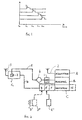
- each square wave represents a small section ofthe 1023 bit code associated with each of the respective four satellites (which of course is transmitted at 1.023 Mbits/s and modulates a carrier at 1.57542 GHz by binary phase shift keying).
- Section A of the GPS receiver is responsible for acquiring via antenna 2 each of the signals from the satellites.
- the receiver uses its time reference to establish the time of day to calculate from the stored satellite orbit details, which satellites are in view, as well as the possible range of Doppler shifts for those satellites. Knowing the uncertainty of its frequency reference, a range of frequencies is defined through which oscillators in the acquisition circuitry must sweep in order to be able to lock onto the frequency of each incoming signal. Then, various values across the range of frequencies are chosen, and time correlation is carried out between the incoming signal (at IF) and the code corresponding to one of the visible satellites (at the same frequency). If no correlation is achieved at the first value of frequency, the procedure is repeated at the second value of frequency in the range, and so on.
- the received signal from the satellite with that particular code can be decoded, and the satellite has been acquired.
- the receiver is now generating a timed signal modulated by 0s and 1s in synchronism (the code phase is the same) with that received and converted to IF in the receiver.
- the data on the received signal indicates that the leading edge was transmitted at time t 0 and, since the data transmitted gives the position of the satellite, the propagation delay is known.
- Section B of the GPS receiver is provided to enable the satellite to be tracked, because the receiver may be moving in different directions relative to the satellite with the result that the received frequency changes in accordance with a Doppler effect. It is therefore necessary to implement a control loop for both carrier frequency and code phase and section B, which is implemented by a microprocessor, is therefore carrying out repeated adjustments of the code phase and carrier frequencies depending on the errors output by the control loop.
- the frequency search must also encompass uncertainty in the local crystal oscillator 1 which is used to generate the codes and the carrier on which they are modulated.
- the data acquired from the first satellite also gives general information (the Almanac) on the orbits of the other satellites and the process of correlation and frequency tracking for the other satellites takes less time since the time and frequency search take place over narrower ranges. This is assisted because the frequency transmitted from the acquired satellite is used to improve the estimate of the uncertainty in the local frequency reference.
- Data from each satellite contains precise orbital parameters, so that the satellite position can be calculated in section F.
- the Navigation Solution section C uses the timing information from B and the position information from F to calculate the user position, which is stored in section E.
- the user position is output, and the calculated error in the crystal oscillator 1 is stored in section H.
- the time of day of the user can be calculated from the satellite signals, and this is stored in section D.
- Section E is connected to a non-volatile memory E 1 which is given the last user position determined and also stores the satellite Almanac data.
- the information in sections D, E and H is for use when the receiver is next switched on.
- the time of day section D of the receiver is connected to a watch crystal D 1 and a watch-like time counter D 2 .
- crystal 1 is temperature controlled in order to provide the best stability and hence the least frequency search necessary to maintain tracking.
- the GPS receiver can also include receiver section G connected to antenna 3 adapted to receive GPS differential correction signals which may be broadcast from a land beacon or from a satellite.
- the differential correction signals are corrections for errors in the GPS system (natural such as changes in the layers of the atmosphere and artificial such as deliberate degradation of the GPS signals introduced by the operators of GPS).
- Differential GPS signals rely on the use of a reference station of known position which receives signals from the satellites.
- the receiver includes an AFC controlled reference crystal 7.
- the radio receiver G may be adapted to receive FM signals broadcast as part of the radio data system (RDS) in a band centred on a subcarrier at around 57 kHz, or signals broadcast in a band centred on a subcarrier at about 66.5 kHz used for paging.
- the receiver may be adapted to receive medium frequency radio signals centred around a 300 kHz for broadcasting time signals for marine purposes, or a low frequency signal for example the time signal carried by the BBC Radio 4 transmitter and used for adjusting time switches.
- the receiver G could be adapted for receiving GSM (the Pan-European Digital Cellular Radio system) transmissions.
- reference information received by the receiver G is used to assist in acquiring the timed signal from the first satellite to be acquired when the receiver is operated i.e. on start-up.
- the reference information consists of time signals sent on line 4 and/or frequency signals sent on line 5.
- acquisition of the first satellite entails carrying out the time correlation procedure at a number of spot frequencies over a range of frequencies which range depended partly on the range of instability of the crystal oscillator 1.
- a temperature-controlled crystal for this purpose.
- frequency comparator 6 uses frequency information from the DGPS/RDS etc to correct for drift in this crystal.
- the frequency information may be the carrier frequency, or alternatively two time-of-day measures can be used in a timer to measure the error in crystal 1.
- the AFC controlled reference crystal of the RDS/GPS receiver could be used, or a single crystal could be used for both receiver C and receiver G, and it would be possible to correct the crystal for drift using off-air signals.
- an off-air time reference can be used, and in this case, the watch-like crystal D 1 and watch-like counter D 2 which are normally provided in a GPS receiver to establish time of day, may be dispensed with altogether.
- the time references are already present in RDS as CT codes, and in the medium, low frequency, and cellular radio system, and it would be possible to add them to normal DGPS messages. Equally, if the receiver G is for GSM or FM or MF time signals, DGPS signals could be added and the receiver adapted to provide differential global positioning corrections.
- the off-air time reference is fed directly to section D.
- a side benefit ofthe system is that it would provide an accurate time signal even when not tracking GPS. This could be used to run a display or for other applications.
- the receiver described is particularly suited to use in motor land vehicles, but could also be used in marine vehicles. Indeed, in the case of cars, many cars are already equipped with RDS, and the additional expenditure to provide the GPS tracking facility would be correspondingly less.
- the output ofthe GPS receiver could be used for vehicle navigation systems.
- the invention is not limited to the Navstar global positioning system but applies to other global positioning systems such as Glonass and systems proposed by Inmarsat.
Landscapes
- Engineering & Computer Science (AREA)
- Radar, Positioning & Navigation (AREA)
- Remote Sensing (AREA)
- Computer Networks & Wireless Communication (AREA)
- Physics & Mathematics (AREA)
- General Physics & Mathematics (AREA)
- Position Fixing By Use Of Radio Waves (AREA)
Applications Claiming Priority (2)
| Application Number | Priority Date | Filing Date | Title |
|---|---|---|---|
| GBGB9524742.5A GB9524742D0 (en) | 1995-12-02 | 1995-12-02 | GPS receiver |
| GB9524742 | 1995-12-02 |
Publications (1)
| Publication Number | Publication Date |
|---|---|
| EP0777129A1 true EP0777129A1 (fr) | 1997-06-04 |
Family
ID=10784867
Family Applications (1)
| Application Number | Title | Priority Date | Filing Date |
|---|---|---|---|
| EP96308548A Withdrawn EP0777129A1 (fr) | 1995-12-02 | 1996-11-27 | Récepteur GPS |
Country Status (3)
| Country | Link |
|---|---|
| EP (1) | EP0777129A1 (fr) |
| JP (1) | JPH09189754A (fr) |
| GB (1) | GB9524742D0 (fr) |
Cited By (3)
| Publication number | Priority date | Publication date | Assignee | Title |
|---|---|---|---|---|
| WO1999044073A1 (fr) * | 1998-02-27 | 1999-09-02 | Ericsson Inc. | Procede et systeme mondial autonome de localisation (gps) a haute sensibilite |
| KR101159569B1 (ko) * | 2006-08-23 | 2012-06-25 | 퀄컴 인코포레이티드 | 수신된 sps 신호에서의 모호성을 감소시키기 위한 시스템 및/또는 방법 |
| DE10128353B4 (de) * | 2001-06-13 | 2014-10-09 | Deutsches Zentrum für Luft- und Raumfahrt e.V. | Digitales Nachrichtenübertragungsverfahren und System zur Durchführung des Verfahrens |
Families Citing this family (6)
| Publication number | Priority date | Publication date | Assignee | Title |
|---|---|---|---|---|
| US5945944A (en) * | 1996-03-08 | 1999-08-31 | Snaptrack, Inc. | Method and apparatus for determining time for GPS receivers |
| EP1094619A2 (fr) * | 1999-10-20 | 2001-04-25 | Sony Corporation | Dispositif de réception de signal pour un système GPS et un système de communication mobile |
| JP4543480B2 (ja) * | 2000-03-02 | 2010-09-15 | ソニー株式会社 | Gps受信機、およびgps測位方法 |
| US6928275B1 (en) * | 2000-05-08 | 2005-08-09 | Qualcomm Incorporated | Method and apparatus for compensating local oscillator frequency error |
| JP2002090441A (ja) * | 2000-09-20 | 2002-03-27 | Clarion Co Ltd | Gps受信装置 |
| JP2005221331A (ja) * | 2004-02-04 | 2005-08-18 | Fujitsu Ltd | Gps受信機 |
Citations (5)
| Publication number | Priority date | Publication date | Assignee | Title |
|---|---|---|---|---|
| US4445118A (en) * | 1981-05-22 | 1984-04-24 | The United States Of America As Represented By The Administrator Of The National Aeronautics And Space Administration | Navigation system and method |
| EP0429769A2 (fr) * | 1989-11-22 | 1991-06-05 | Pioneer Electronic Corporation | Méthode de suivi de signaux radio émanant de satellites dans un récepteur GPS |
| EP0561539A2 (fr) * | 1992-03-16 | 1993-09-22 | Pioneer Electronic Corporation | Méthode de sélection de largeur de bande de recherche d'un récepteur GPS |
| WO1994028434A1 (fr) | 1993-05-21 | 1994-12-08 | Trimble Navigation Limited | Acquisition rapide d'un signal de satellite dans un systeme de positionnement de satellite |
| US5477458A (en) * | 1994-01-03 | 1995-12-19 | Trimble Navigation Limited | Network for carrier phase differential GPS corrections |
-
1995
- 1995-12-02 GB GBGB9524742.5A patent/GB9524742D0/en active Pending
-
1996
- 1996-11-27 EP EP96308548A patent/EP0777129A1/fr not_active Withdrawn
- 1996-11-29 JP JP33458296A patent/JPH09189754A/ja active Pending
Patent Citations (6)
| Publication number | Priority date | Publication date | Assignee | Title |
|---|---|---|---|---|
| US4445118A (en) * | 1981-05-22 | 1984-04-24 | The United States Of America As Represented By The Administrator Of The National Aeronautics And Space Administration | Navigation system and method |
| EP0429769A2 (fr) * | 1989-11-22 | 1991-06-05 | Pioneer Electronic Corporation | Méthode de suivi de signaux radio émanant de satellites dans un récepteur GPS |
| EP0561539A2 (fr) * | 1992-03-16 | 1993-09-22 | Pioneer Electronic Corporation | Méthode de sélection de largeur de bande de recherche d'un récepteur GPS |
| WO1994028434A1 (fr) | 1993-05-21 | 1994-12-08 | Trimble Navigation Limited | Acquisition rapide d'un signal de satellite dans un systeme de positionnement de satellite |
| US5418538A (en) * | 1993-05-21 | 1995-05-23 | Trimble Navigation Limited | Rapid satellite signal acquisition in a satellite positioning system |
| US5477458A (en) * | 1994-01-03 | 1995-12-19 | Trimble Navigation Limited | Network for carrier phase differential GPS corrections |
Non-Patent Citations (1)
| Title |
|---|
| CHARLES BELOVE: "Handbook of Modern Electronics and Electrical Engineering", 1986, JOHN WILEY & SONS INC., USA, pages: 1978 - 1988 |
Cited By (5)
| Publication number | Priority date | Publication date | Assignee | Title |
|---|---|---|---|---|
| WO1999044073A1 (fr) * | 1998-02-27 | 1999-09-02 | Ericsson Inc. | Procede et systeme mondial autonome de localisation (gps) a haute sensibilite |
| US6075987A (en) * | 1998-02-27 | 2000-06-13 | Ericsson Inc. | Stand alone global positioning system (GPS) and method with high sensitivity |
| DE10128353B4 (de) * | 2001-06-13 | 2014-10-09 | Deutsches Zentrum für Luft- und Raumfahrt e.V. | Digitales Nachrichtenübertragungsverfahren und System zur Durchführung des Verfahrens |
| KR101159569B1 (ko) * | 2006-08-23 | 2012-06-25 | 퀄컴 인코포레이티드 | 수신된 sps 신호에서의 모호성을 감소시키기 위한 시스템 및/또는 방법 |
| KR101159570B1 (ko) * | 2006-08-23 | 2012-06-25 | 퀄컴 인코포레이티드 | 수신된 sps 신호에서의 모호성을 감소시키기 위한 시스템 및/또는 방법 |
Also Published As
| Publication number | Publication date |
|---|---|
| GB9524742D0 (en) | 1996-02-07 |
| JPH09189754A (ja) | 1997-07-22 |
Similar Documents
| Publication | Publication Date | Title |
|---|---|---|
| US4445118A (en) | Navigation system and method | |
| EP1436909B1 (fr) | Recepteur de systeme de localisation par satellite comprenant un circuit oscillateur de reference et procedes associes | |
| US6064336A (en) | GPS receiver utilizing a communication link | |
| US6546040B1 (en) | GPS receiver having improved signal acquisition at a low signal to noise ratio | |
| US5663735A (en) | GPS receiver using a radio signal for improving time to first fix | |
| CN1936616B (zh) | 处理gps信号的gps接收机及方法 | |
| US5917444A (en) | Reduction of time to first fix in an SATPS receiver | |
| EP1979760B1 (fr) | Récepteur gps intérieur non assisté | |
| GB2307812A (en) | GPS Receiver | |
| US7586382B2 (en) | Methods and systems for temperature related frequency drift compensation | |
| AU582613B2 (en) | Digital circuit for correcting phase shift of locally derived gold code relative to gold code sequence received from satellite in global positioning system/navstar | |
| US8681043B2 (en) | Method and system for sharing an oscillator for processing cellular radio signals and GNSS radio data signals by deferring AFC | |
| WO1999044073A1 (fr) | Procede et systeme mondial autonome de localisation (gps) a haute sensibilite | |
| EP1821114A2 (fr) | Appareil et procédé de partage d'un TCXO d'un terminal mobile utilisant un système de positionnement global dans un système de communication mobile | |
| US6240276B1 (en) | Compensating for errors in tuning frequency of a global positioning satellite (GPS) receiver | |
| US20110212718A1 (en) | Methods and apparatus for stabilizing reference oscillators | |
| JPH09189754A (ja) | Gps受信装置 | |
| EP1798564B1 (fr) | Récepteur GPS amélioré avec compensation du décalage Doppler par connaissance des positions des satellites | |
| Gupta et al. | Satellite broadcasting of time and frequency signals | |
| WO2002009310A2 (fr) | Compensation du reglage de frequence pour poursuite ou acquisition d'un ou de plusieurs signaux de position | |
| RU2187127C2 (ru) | Способ автономного снижения порогов обнаружения и отслеживания несущих сигналов, принимаемых на орбите | |
| Lombardi | Time flies! radio signals used for time and frequency measurements | |
| Oaks | Time Transfer by Satellite | |
| Putkovich | Time dissemination capabilities via navigation satellites | |
| HK1105459B (en) | An improved gps receiver utilizing satellite position information for compensating doppler |
Legal Events
| Date | Code | Title | Description |
|---|---|---|---|
| PUAI | Public reference made under article 153(3) epc to a published international application that has entered the european phase |
Free format text: ORIGINAL CODE: 0009012 |
|
| AK | Designated contracting states |
Kind code of ref document: A1 Designated state(s): AT DE ES FR GB IT |
|
| 17P | Request for examination filed |
Effective date: 19971203 |
|
| RAP1 | Party data changed (applicant data changed or rights of an application transferred) |
Owner name: MITEL SEMICONDUCTOR LIMITED |
|
| 17Q | First examination report despatched |
Effective date: 19981118 |
|
| STAA | Information on the status of an ep patent application or granted ep patent |
Free format text: STATUS: THE APPLICATION IS DEEMED TO BE WITHDRAWN |
|
| 18D | Application deemed to be withdrawn |
Effective date: 19990330 |