EP0798540B1 - Méthode pour référencer des objets localisés - Google Patents
Méthode pour référencer des objets localisés Download PDFInfo
- Publication number
- EP0798540B1 EP0798540B1 EP97250087A EP97250087A EP0798540B1 EP 0798540 B1 EP0798540 B1 EP 0798540B1 EP 97250087 A EP97250087 A EP 97250087A EP 97250087 A EP97250087 A EP 97250087A EP 0798540 B1 EP0798540 B1 EP 0798540B1
- Authority
- EP
- European Patent Office
- Prior art keywords
- objects
- grid
- grid system
- code
- traffic
- Prior art date
- Legal status (The legal status is an assumption and is not a legal conclusion. Google has not performed a legal analysis and makes no representation as to the accuracy of the status listed.)
- Expired - Lifetime
Links
- 238000000034 method Methods 0.000 title claims abstract description 37
- 230000002441 reversible effect Effects 0.000 claims abstract description 13
- 238000012545 processing Methods 0.000 claims description 6
- 238000004891 communication Methods 0.000 claims description 2
- 238000004364 calculation method Methods 0.000 description 5
- 230000005540 biological transmission Effects 0.000 description 4
- 230000008901 benefit Effects 0.000 description 3
- 238000006243 chemical reaction Methods 0.000 description 3
- 238000012546 transfer Methods 0.000 description 3
- 238000013459 approach Methods 0.000 description 2
- 230000000295 complement effect Effects 0.000 description 2
- 238000005516 engineering process Methods 0.000 description 2
- 230000005484 gravity Effects 0.000 description 2
- 230000000739 chaotic effect Effects 0.000 description 1
- 230000000694 effects Effects 0.000 description 1
- 238000011156 evaluation Methods 0.000 description 1
- 230000006870 function Effects 0.000 description 1
- 238000013507 mapping Methods 0.000 description 1
- 210000002023 somite Anatomy 0.000 description 1
Images


Classifications
-
- G—PHYSICS
- G01—MEASURING; TESTING
- G01C—MEASURING DISTANCES, LEVELS OR BEARINGS; SURVEYING; NAVIGATION; GYROSCOPIC INSTRUMENTS; PHOTOGRAMMETRY OR VIDEOGRAMMETRY
- G01C21/00—Navigation; Navigational instruments not provided for in groups G01C1/00 - G01C19/00
- G01C21/26—Navigation; Navigational instruments not provided for in groups G01C1/00 - G01C19/00 specially adapted for navigation in a road network
Definitions
- the invention relates to a method for referencing fixed objects the surface of the earth by assigning a unique code.
- a terminal can, for example, in built into a vehicle or designed to be mobile as a portable device.
- the Information is usually collected through a service center or system Service stations provided.
- Much of the information to be transmitted refers to geographic positions. Typical examples are any type of traffic information. It is therefore necessary that the transmitted Position information can also be assigned correctly so that the traffic information can be used sensibly.
- the entire route of the A 57 motorway is one parent section and about the sections of the A 57 between the cross Strümpp and the Krefeld-Oppum exit or between the Wien Kaarst and the Departure Neuss-Büttgen are subordinate sections.
- Such individual sections can then be simply numbered, as shown in Fig. 1 for a Map section is shown schematically.
- Information is then always with Transfer reference to the number of the predefined section.
- the method has the advantage of a minimal data volume for referencing the transfer of information.
- Crucial disadvantage of this and many others The procedure is that the information transfer depends on the reference model (in in this case from the given road network structure) and this reference model must also be known to the user in the corresponding terminal device so that the Information can be understood correctly.
- a refinement of the model is in usually not possible. Different geographical models (e.g. street maps different manufacturers) cannot be used due to the different structure become. When the structure changes, the data display becomes increasingly chaotic, so that compatibility problems between both different devices as well can occur between different releases of the data structure.
- Different geographical models e.g. street maps different manufacturers
- intersection There is an intersection on both manufacturer A's card and manufacturer's card B is an intersection, but it is the rule that this intersection has WGS coordinates assigned, which often differ from each other by up to 100 m. The use of such coordinates therefore does not allow any one that is unique for all manufacturers Assignment.
- DE 37 44 533 A1 discloses the determination of the center of gravity coordinates of houses for a digital map.
- EP 0 242 050 A1 discloses the determination of two-dimensional location coordinates for a non-stationary, moving body.
- DE 40 28 214 A1 discloses the Determination of Cartesian coordinates of a moving object based on continuous generated location data of the moving object.
- the object of the invention is a method for referencing fixed Objects by assigning a unique code to improve that the aforementioned compatibility problems with the least possible effort be overcome. Furthermore, a system for carrying out traffic telematics Services and a suitable end device are specified that the overcomes the compatibility problems mentioned.
- the grid it is recommended to use the grid as orthogonal or at least approximately to define an orthogonal grid.
- the mesh size is narrower in areas with many objects per unit area than in areas with fewer objects per unit area.
- the Extension of the grid to a geographical area e.g. on a national territory or limited to one continent. This allows for a given length of the individual codes (number of characters) achieve a higher resolution.
- This Context should determine the size of the geographic area be taken into account.
- the mesh size of the grid to be defined in Range of 50 to 500 m and particularly preferably in the range of an order of magnitude of 100 m.
- the The method according to the invention is preferably a supranational one Coordinate system such as the geographic coordinate system WGS-84 used.
- the objects are mapped to the nodes of the defined grid preferably such that an object is assigned to the node that is closest to the object, and only in the event that the node Another object has already been assigned, another node nearby of the object is selected for the assignment.
- step c of the method according to the invention can, for example formed by numbering the individual nodes of the grid become.
- the referencing according to the invention is not only suitable for real, but also for virtual objects. So not only real objects like intersections, Road junctions, road structures (e.g. bridges or tunnels) and cities (i.e. Reference objects with a considerable area), but also virtual objects such as countries, states or other administrative districts. This one Objects simply become a corresponding point on the grid (e.g. that of the Center of gravity nearest point) clearly assigned.
- the received Codes of the objects can be used for further use e.g. into a reference table can be fed in, in which attributes are assigned to the codes. As special important attributes are the name and / or street type and / or size of a To name territory and / or a reference to other objects.
- a system for the implementation of telematics services with one Central which is equipped with an electronic data processing system and Collects, stores and stores traffic information about you Communication channel provides, and with a variety of devices that Traffic information can be received from the headquarters and for each According to the invention, making users available is characterized in that the Programming of the electronic data processing system is set up in such a way that traffic-relevant objects with the above Process steps a to d are referenced.
- a terminal for such a system is characterized according to the invention in that that the terminal has an electronic data processing device, which as Decoder is programmed to decode referencing Traffic information referenced with the inventive method were. It is expedient to have one in a memory of the terminal Reference table stored in which the codes of the objects contain and the codes Attributes are assigned, in particular names and / or street type and / or size an area and / or a reference to other objects.
- the present invention overcomes the aforementioned Compatibility issues. This is illustrated below using the example of Traffic information and its assignment to a road network explained in more detail. However, the method according to the invention is not applicable to this in its application Area limited, but can be more generally in the assignment of Use information about a geographic location.
- the aim of the method according to the invention is the geographic To make the data structure as simple and universal as possible.
- the solution principle uses features such as those outlined in the two at the beginning 1 and 2 explained methods according to the prior art are known, and put them together in a new, particularly advantageous manner.
- the density of information within a street map is very different. So fall for displaying downtown streets or a motorway junction on very a lot of information. Conversely, stand for such objects also a lot of information (e.g. about the traffic flow) is available.
- the basic idea The invention is now that similar to the relevant methods of finite element calculation adapts a network structure to the problem at hand and additional grid points defined at particularly interesting points. This additional grid points are not, however, as in the finite element calculation defined based on their actual coordinates, but are converted into a fictional one Converted grid. To do this, a simple grid on the surface of the earth Are defined. This grid is expediently connected to a common coordinate system ajar. However, this does not have to be square or rectangular. On Essential feature of the invention is that the grid coordinates as arbitrarily defined coordinates can be understood.
- the application of the method according to the invention is not a two-dimensional one Grid limited, but is also advantageous when referencing in 3-dimensional Systems. In the following, however, reference is made to the preferred application in road traffic, so in the further description regularly a 2-dimensional projection based on the earth's surface is placed.
- the actually stored grid is based on a predetermined algorithm reversibly mapped onto this coordinate network, i.e. distorted.
- a predetermined algorithm reversibly mapped onto this coordinate network, i.e. distorted.
- Edge length in the order of 100 m has proven to be particularly useful. Larger or smaller grid spacings are of course possible, but must against the background of transmission efficiency, i.e. the smaller the Edge length, the more grid points there are and the longer the code becomes Identification of a grid point. If you choose a grid spacing of 100 m Assignment to the real geographic position regularly with an accuracy of expected a few 100 m. This accuracy is sufficient to be detailed Linking traffic information adequately to road sections and on the other hand the negative effects of inaccuracies or Completely overcome contradictions on the digital map level.
- Part 3a shows a map section with a route network various points of interest in terms of transport technology, i.e. fixed objects such as a motorway junction with the various branches, regular freeway entrances and -Departs, parking lots, rest areas, etc.
- the objects of this Map sections are now exemplary, as is the case in sub-figure 3b is shown, assigned to the grid node of a predefined coordinate network.
- the real position of the objects is indicated in Fig. 3b by (open) circles while the distortion caused by the mapping algorithm applied corresponding black dots is shown.
- the algorithm provides that An attempt is first made to object the nearest grid node assign.
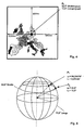
- the reference point P o (latitude 52.5 °, longitude 13.5 °) is first defined as the zero point of a Cartesian coordinate system for the selected area. The positions of individual objects are determined with their respective distances in the west-east (x direction) and in the south-north direction (y direction) from this zero point P o .
- the numerical value 400300 in the formula represents that in grid spacing units (100 m) measured equator circumference of the earth globe of approx. 40030 km.
- This Information can be encrypted in 16 bits (two complement). Both 16 bit lines e.g. in the order x and y simply attached to a 32 Bit string that is converted to a number and represents the geocode.
- the latitude is first determined ⁇ 1 and then using the value of ⁇ 1 of the longitude ⁇ . 1
- ⁇ 1 the latitude
- ⁇ 1 the longitude
- ⁇ . 1 a restriction to nine significant decimal places (32 bits) is permissible for sufficient accuracy.
Landscapes
- Engineering & Computer Science (AREA)
- Radar, Positioning & Navigation (AREA)
- Remote Sensing (AREA)
- Automation & Control Theory (AREA)
- Physics & Mathematics (AREA)
- General Physics & Mathematics (AREA)
- Instructional Devices (AREA)
- Radar Systems Or Details Thereof (AREA)
- Transition And Organic Metals Composition Catalysts For Addition Polymerization (AREA)
- Devices For Executing Special Programs (AREA)
- Management, Administration, Business Operations System, And Electronic Commerce (AREA)
- Traffic Control Systems (AREA)
Claims (19)
- Procédé pour référencer des objets fixes sur la surface terrestre par association d'un code univoque,
caractérisé par les étapes suivantes :a) il est défini un réseau de quadrillage ayant une résolution prédéfinie (taille de maille) et une position prédéfinie relativement à la surface terrestre, les points nodaux du réseau de quadrillage pouvant être convertis en un système de coordonnées géographique par une première prescription de calcul réversible,b) les objets sont représentés de façon biunivoque sur les points nodaux du réseau de quadrillage,c) aux points nodaux du réseau de quadrillage, il est associé, à chaque fois de façon biunivoque, un code par une seconde prescription de calcul réversible,d) à l'objet respectif, il est associé le code, déterminé dans l'étape c), du point nodal associé. - Procédé selon la revendication 1,
caractérisé en ce que le réseau de quadrillage est défini comme réseau de quadrillage orthogonal par approximation. - Procédé selon la revendication 1,
caractérisé en ce que le réseau de quadrillage est défini comme réseau de quadrillage déformé ayant une largeur de maille non uniforme, la largeur de maille étant plus étroite dans des régions ayant de nombreux objets par unité de surface que dans des régions ayant moins d'objets par unité de surface. - Procédé selon une des revendications 1 à 3,
caractérisé en ce que l'extension du réseau de quadrillage est limitée à une région géographique. - Procédé selon la revendication 4,
caractérisé en ce que la taille de la région géographique et la résolution du réseau de quadrillage sont déterminées de façon dépendant de la longueur prédéfinie du code (nombre de caractères). - Procédé selon une des revendications 1 à 5,
caractérisé en ce que la taille de maille pour des utilisations télématiques de trafic est déterminée dans la plage de 50 à 500 m. - Procédé selon la revendication 6,
caractérisé en ce que la taille de maille est de l'ordre de grandeur de 100 m. - Procédé selon une des revendications 1 à 7,
caractérisé en ce que, comme système de coordonnées géographique, il est utilisé un système de coordonnées en vigueur de façon internationale. - Procédé selon la revendication 8,
caractérisé en ce que, comme système de coordonnées géographique, il est utilisé le système WGS-84. - Procédé selon une des revendications 1 à 9,
caractérisé en ce que la représentation des objets sur les points nodaux du réseau de quadrillage est effectuée de façon qu'un objet est associé, à chaque fois, au point nodal qui est le plus proche de l'objet et, uniquement dans le cas où, au point nodal, un autre objet a déjà été associé, un autre point nodal est choisi à proximité de l'objet pour l'association. - Procédé selon une des revendications 1 à 10,
caractérisé en ce que les codes dans l'étape c) sont formés par numérotation des points nodaux individuels du réseau de quadrillage. - Procédé selon une des revendications 1 à 10,
caractérisé en ce que les codes dans l'étape c) sont formés, à chaque fois, comme suites de chiffres, qui sont créées par mise à la file des coordonnées de façon correspondant à un réseau de quadrillage réalisé comme système de coordonnées cartésien. - Procédé selon une des revendications 1 à 12,
caractérisé en ce que, à côté d'objets réels, également des objets virtuels sont référencés. - Procédé selon la revendication 13,
caractérisé en ce que, comme objets, sont référencés des carrefours, embranchements routiers, constructions routières, villes, états, pays, et districts administratifs quelconques. - Procédé selon une des revendications 1 à 14,
caractérisé en ce que les codes des objets sont mémorisés, à chaque fois, dans une table de référence, dans laquelle des attributs sont associés aux codes. - Procédé selon la revendication 15,
caractérisé en ce que, comme attributs, un nom et/ou un type de voie routière et/ou la taille d'une région et/ou une relation par rapport à d'autres objets sont employés. - Système pour effectuer des services télématiques de trafic, comportant une centrale, qui est équipé d'une installation électronique de traitement de données et collecte des informations de trafic, les mémorise et les met à disposition d'utilisateurs par l'intermédiaire d'un canal de communication, et une pluralité de terminaux, qui peuvent recevoir des informations de trafic de la centrale et les rendre disponibles pour l'utilisateur respectif,
caractérisé en ce que la programmation de l'installation électronique de traitement de données est adaptée de sorte que des objets significatifs au niveau du trafic, dans les informations de trafic, sont référencés suivant le procédé selon la revendication 1. - Terminal pour un système selon la revendication 17,
caractérisé en ce que le terminal présente un dispositif électronique de traitement de données, qui est programmé comme décodeur pour décoder des références dans des informations de trafic, qui sont référencées par le procédé selon la revendication 1. - Terminal selon la revendication 18,
caractérisé en ce qu'une table de référence, engendrée suivant le procédé selon la revendication 15 ou 16, est stockée dans une mémoire du terminal.
Applications Claiming Priority (2)
| Application Number | Priority Date | Filing Date | Title |
|---|---|---|---|
| DE19613013 | 1996-03-25 | ||
| DE19613013 | 1996-03-25 |
Publications (2)
| Publication Number | Publication Date |
|---|---|
| EP0798540A1 EP0798540A1 (fr) | 1997-10-01 |
| EP0798540B1 true EP0798540B1 (fr) | 2001-08-22 |
Family
ID=7790161
Family Applications (1)
| Application Number | Title | Priority Date | Filing Date |
|---|---|---|---|
| EP97250087A Expired - Lifetime EP0798540B1 (fr) | 1996-03-25 | 1997-03-20 | Méthode pour référencer des objets localisés |
Country Status (5)
| Country | Link |
|---|---|
| US (1) | US6023654A (fr) |
| EP (1) | EP0798540B1 (fr) |
| AT (1) | ATE204644T1 (fr) |
| DE (1) | DE59704345D1 (fr) |
| ES (1) | ES2160298T3 (fr) |
Families Citing this family (32)
| Publication number | Priority date | Publication date | Assignee | Title |
|---|---|---|---|---|
| EP0947970A1 (fr) * | 1998-03-18 | 1999-10-06 | Mentz Datenverarbeitung GmbH | Référencer géographiquement des réseaux de transport en commun |
| EP1020832A1 (fr) * | 1998-04-28 | 2000-07-19 | Robert Bosch Gmbh | Méthode de génération d'un ensemble de locations de référence dans un carte numérique |
| DE19905431A1 (de) * | 1999-02-10 | 2000-08-17 | Bosch Gmbh Robert | Verfahren zur Übertragung von auf Orte bezogenen Informationen |
| DE19949698A1 (de) * | 1999-10-15 | 2001-04-19 | Alcatel Sa | Verfahren zur Erzeugung einer digitalen Fahrwege-Netzkarte |
| DE10052109B4 (de) * | 1999-11-11 | 2014-10-30 | Deutsche Telekom Ag | Verfahren zum Beschreiben und Erzeugen von Straßennetzen und Straßennetz |
| US6850840B1 (en) | 1999-11-11 | 2005-02-01 | Volkswagen Ag | Method for describing and generating road networks and corresponding road network |
| DE10015935A1 (de) * | 2000-03-30 | 2001-10-04 | Bosch Gmbh Robert | Verfahren zur Übertragung einer Position einer Verkehrsinformation, insbesondere einer Verkehrsstörung |
| US7894986B2 (en) * | 2000-06-02 | 2011-02-22 | Navteq North America, Llc | Method and system for forming a keyword database for referencing physical locations |
| US6487495B1 (en) | 2000-06-02 | 2002-11-26 | Navigation Technologies Corporation | Navigation applications using related location-referenced keywords |
| US6704564B1 (en) | 2000-09-22 | 2004-03-09 | Motorola, Inc. | Method and system for controlling message transmission and acceptance by a telecommunications device |
| AU2001222781A1 (en) * | 2000-12-19 | 2002-07-01 | Gatco | System and method for communicating data messages from a cell phone terminal, such as a geographical location |
| US6611751B2 (en) | 2001-03-23 | 2003-08-26 | 981455 Alberta Ltd. | Method and apparatus for providing location based data services |
| DE10137632A1 (de) * | 2001-08-03 | 2003-02-27 | Daimler Chrysler Ag | Verfahren und System zum Auffinden eines Ortes in einer digitalen Karte |
| EP1283407B1 (fr) * | 2001-08-10 | 2012-10-03 | Pioneer Corporation | Appareil pour fournir des données de plans |
| US6882315B2 (en) * | 2001-10-18 | 2005-04-19 | Multispectral Solutions, Inc. | Object location system and method |
| US7872647B2 (en) * | 2002-07-19 | 2011-01-18 | Rockwell Collins Simulation And Training Solutions Llc | System and method for modeling a spheroid world database |
| DE10239440A1 (de) * | 2002-08-28 | 2004-03-11 | Robert Bosch Gmbh | Verfahren zum Ermitteln von Kartendaten |
| WO2005001794A1 (fr) * | 2003-06-27 | 2005-01-06 | Nec Software Chubu, Ltd. | Module de conversion mutuelle de coordonnées |
| US7212916B2 (en) | 2004-12-14 | 2007-05-01 | International Business Machines Corporation | Obtaining contextual vehicle information |
| US7912630B2 (en) * | 2004-12-14 | 2011-03-22 | International Business Machines Corporation | Method and system for performing programmatic actions based upon vehicle approximate locations |
| DE102007016978A1 (de) | 2007-04-10 | 2008-10-16 | Bayerische Motoren Werke Aktiengesellschaft | Verfahren zur Darstellung eines Wetterereignisses und Anzeigesystem |
| US8198980B1 (en) | 2007-09-21 | 2012-06-12 | Luger Dale J | Numeric geodesic locator |
| US20100002012A1 (en) * | 2008-07-03 | 2010-01-07 | Sony Ericsson Mobile Communications Ab | Methods, electronic devices, and computer program products for providing geographical presence using map tiles |
| US8774468B2 (en) * | 2009-09-08 | 2014-07-08 | Schlumberger Technology Corporation | Dynamic shape approximation |
| WO2016077506A1 (fr) | 2014-11-11 | 2016-05-19 | Bent Image Lab, Llc | Positionnement précis d'un contenu de réalité augmentée |
| US10600249B2 (en) | 2015-10-16 | 2020-03-24 | Youar Inc. | Augmented reality platform |
| DE102015121106A1 (de) * | 2015-12-03 | 2017-06-08 | Helmut Weismeier | System und verfahren zur indoor-navigation |
| WO2017165705A1 (fr) | 2016-03-23 | 2017-09-28 | Bent Image Lab, Llc | Réalité augmentée pour l'internet des objets |
| US10878632B2 (en) * | 2017-09-29 | 2020-12-29 | Youar Inc. | Planet-scale positioning of augmented reality content |
| US10255728B1 (en) * | 2017-09-29 | 2019-04-09 | Youar Inc. | Planet-scale positioning of augmented reality content |
| CN108088455A (zh) * | 2017-12-14 | 2018-05-29 | 山东中图软件技术有限公司 | 一种导航方法 |
| CN114911797B (zh) * | 2022-05-05 | 2025-01-28 | 福建安能数通科技有限公司 | 一种kks码与网格编码融合应用的方法 |
Family Cites Families (7)
| Publication number | Priority date | Publication date | Assignee | Title |
|---|---|---|---|---|
| CA1295737C (fr) * | 1986-03-14 | 1992-02-11 | Akira Ichikawa | Appareil d'affichage des trajets de voyage |
| DE3744533A1 (de) * | 1987-12-30 | 1989-07-13 | Bosch Gmbh Robert | Verfahren fuer strassennetzabbildungen in datenspeichern |
| DE4028214C2 (de) * | 1990-09-06 | 1996-05-30 | Nuclear Cargo & Service Gmbh | Verfahren zur Umsetzung von in Werten eines geographischen Koordinatensystems erzeugten Standortdaten in eine auf einem karthesischen Koordinatensystem beruhende Rasterform |
| US5272638A (en) * | 1991-05-31 | 1993-12-21 | Texas Instruments Incorporated | Systems and methods for planning the scheduling travel routes |
| DE4340147A1 (de) * | 1993-11-25 | 1995-09-14 | Bosch Gmbh Robert | Verfahren und Vorrichtung zur Ortsbestimmung vorzugsweise eines geographischen Ortes oder eines Speicherplatzes |
| US5731978A (en) * | 1995-06-07 | 1998-03-24 | Zexel Corporation | Method and apparatus for enhancing vehicle navigation through recognition of geographical region types |
| US5748197A (en) * | 1995-12-29 | 1998-05-05 | Xerox Corporation | Dynamic computation of a line segment arrangement using finite precision arithmetic for use in a processor controlled system |
-
1997
- 1997-03-20 DE DE59704345T patent/DE59704345D1/de not_active Expired - Lifetime
- 1997-03-20 AT AT97250087T patent/ATE204644T1/de not_active IP Right Cessation
- 1997-03-20 EP EP97250087A patent/EP0798540B1/fr not_active Expired - Lifetime
- 1997-03-20 ES ES97250087T patent/ES2160298T3/es not_active Expired - Lifetime
- 1997-03-25 US US08/823,145 patent/US6023654A/en not_active Expired - Lifetime
Also Published As
| Publication number | Publication date |
|---|---|
| DE59704345D1 (de) | 2001-09-27 |
| US6023654A (en) | 2000-02-08 |
| ATE204644T1 (de) | 2001-09-15 |
| EP0798540A1 (fr) | 1997-10-01 |
| ES2160298T3 (es) | 2001-11-01 |
Similar Documents
| Publication | Publication Date | Title |
|---|---|---|
| EP0798540B1 (fr) | Méthode pour référencer des objets localisés | |
| DE3854785T2 (de) | Navigationssystem | |
| DE69736967T2 (de) | Gerät zur Gewinnung von Strassennetzzonendaten aus den Blockdaten einer Strassennetzkarte, System zum Umformen dieser Daten und Darstellung einer umgeformten Karte und geographisches Informationssystem | |
| DE69732015T2 (de) | Karthographisches Datenbankgerät | |
| DE69625084T2 (de) | Kostengebiete | |
| EP0902406B1 (fr) | Procédé de transmission de données routières et d'analyse du réseau de circulation routière, unité centrale de mesure du trafic routier et terminal associé | |
| DE69729426T2 (de) | Kartographisches Datenbankgerät | |
| DE69929639T2 (de) | Kartendatenzugriffverfahren für Navigation und Navigationssystem | |
| DE4104351A1 (de) | Im fahrzeug montiertes navigationssystem | |
| EP0730726A1 (fr) | Procede de realisation d'une carte routiere numerisee | |
| EP1281933B1 (fr) | Procédé et système pour trouver un lieu dans une carte numérique | |
| DE10051908A1 (de) | Navigationssystem | |
| DE69901242T2 (de) | Verfahren zur erzeugung und interpretation einer positionsreferenz für eine digitale karte | |
| EP0276366A1 (fr) | Méthode de correction de la localisation de véhicules terrestres dans un enclos | |
| DE19729914A1 (de) | Verfahren zur Analyse eines Verkehrsnetzes, Verkehrsanalyse, Verkehrsprognose sowie Erzeugung einer historischen Verkehrsdatenbank und Verkehrsanalyse- und -prognosezentrale | |
| EP1301756B1 (fr) | Procede et dispositif de codage, de decodage et/ou de transmission d'informations locales | |
| EP1376063A2 (fr) | Procédé d'entrée de destination dans un appareil de navigation et base de données de navigation | |
| DE112012005733B4 (de) | Kartendatenstruktur, Kartendatenerstellungsverfahren und Bordinformationsterminal | |
| DE19733179A1 (de) | Datensendungsempfänger | |
| DE19816585A1 (de) | Verfahren zur Routeninformation eines Endgerät-Benutzers durch Übermittlung von Routeninformationen von einer Zentrale an das Endgerät | |
| DE60106857T2 (de) | Verfahren und Vorrichtung für Referenzstandorte in der Transporttelematik | |
| DE4340147A1 (de) | Verfahren und Vorrichtung zur Ortsbestimmung vorzugsweise eines geographischen Ortes oder eines Speicherplatzes | |
| EP2198244A1 (fr) | Procédé permettant de faire fonctionner un système de navigation | |
| DE10052934A1 (de) | Verfahren zur Bestimmung eines Weges zwischen einem Ausgangspunkt und einem Endpunkt eines Netzes, wie beispielsweise Straßennetzes | |
| DE102009045455A1 (de) | Bordseitige Fahrzeugnavigation-Zielsuchvorrichtung und bordseitiges Fahrzeugnavigation-Zielsuchverfahren |
Legal Events
| Date | Code | Title | Description |
|---|---|---|---|
| PUAI | Public reference made under article 153(3) epc to a published international application that has entered the european phase |
Free format text: ORIGINAL CODE: 0009012 |
|
| AK | Designated contracting states |
Kind code of ref document: A1 Designated state(s): AT BE CH DE DK ES FI FR GB GR IT LI NL PT SE |
|
| 17P | Request for examination filed |
Effective date: 19970826 |
|
| 17Q | First examination report despatched |
Effective date: 20000215 |
|
| GRAG | Despatch of communication of intention to grant |
Free format text: ORIGINAL CODE: EPIDOS AGRA |
|
| GRAG | Despatch of communication of intention to grant |
Free format text: ORIGINAL CODE: EPIDOS AGRA |
|
| GRAH | Despatch of communication of intention to grant a patent |
Free format text: ORIGINAL CODE: EPIDOS IGRA |
|
| GRAH | Despatch of communication of intention to grant a patent |
Free format text: ORIGINAL CODE: EPIDOS IGRA |
|
| GRAA | (expected) grant |
Free format text: ORIGINAL CODE: 0009210 |
|
| AK | Designated contracting states |
Kind code of ref document: B1 Designated state(s): AT BE CH DE DK ES FI FR GB GR IT LI NL PT SE |
|
| PG25 | Lapsed in a contracting state [announced via postgrant information from national office to epo] |
Ref country code: FI Free format text: LAPSE BECAUSE OF FAILURE TO SUBMIT A TRANSLATION OF THE DESCRIPTION OR TO PAY THE FEE WITHIN THE PRESCRIBED TIME-LIMIT Effective date: 20010822 |
|
| REF | Corresponds to: |
Ref document number: 204644 Country of ref document: AT Date of ref document: 20010915 Kind code of ref document: T |
|
| REG | Reference to a national code |
Ref country code: CH Ref legal event code: NV Representative=s name: E. BLUM & CO. PATENTANWAELTE Ref country code: CH Ref legal event code: EP |
|
| REF | Corresponds to: |
Ref document number: 59704345 Country of ref document: DE Date of ref document: 20010927 |
|
| GBT | Gb: translation of ep patent filed (gb section 77(6)(a)/1977) |
Effective date: 20011005 |
|
| REG | Reference to a national code |
Ref country code: ES Ref legal event code: FG2A Ref document number: 2160298 Country of ref document: ES Kind code of ref document: T3 |
|
| PG25 | Lapsed in a contracting state [announced via postgrant information from national office to epo] |
Ref country code: SE Free format text: LAPSE BECAUSE OF FAILURE TO SUBMIT A TRANSLATION OF THE DESCRIPTION OR TO PAY THE FEE WITHIN THE PRESCRIBED TIME-LIMIT Effective date: 20011122 Ref country code: PT Free format text: LAPSE BECAUSE OF FAILURE TO SUBMIT A TRANSLATION OF THE DESCRIPTION OR TO PAY THE FEE WITHIN THE PRESCRIBED TIME-LIMIT Effective date: 20011122 Ref country code: DK Free format text: LAPSE BECAUSE OF FAILURE TO SUBMIT A TRANSLATION OF THE DESCRIPTION OR TO PAY THE FEE WITHIN THE PRESCRIBED TIME-LIMIT Effective date: 20011122 |
|
| PG25 | Lapsed in a contracting state [announced via postgrant information from national office to epo] |
Ref country code: GR Free format text: LAPSE BECAUSE OF FAILURE TO SUBMIT A TRANSLATION OF THE DESCRIPTION OR TO PAY THE FEE WITHIN THE PRESCRIBED TIME-LIMIT Effective date: 20011123 |
|
| REG | Reference to a national code |
Ref country code: GB Ref legal event code: IF02 |
|
| ET | Fr: translation filed | ||
| PLBE | No opposition filed within time limit |
Free format text: ORIGINAL CODE: 0009261 |
|
| STAA | Information on the status of an ep patent application or granted ep patent |
Free format text: STATUS: NO OPPOSITION FILED WITHIN TIME LIMIT |
|
| 26N | No opposition filed | ||
| PGFP | Annual fee paid to national office [announced via postgrant information from national office to epo] |
Ref country code: CH Payment date: 20030218 Year of fee payment: 7 |
|
| PGFP | Annual fee paid to national office [announced via postgrant information from national office to epo] |
Ref country code: NL Payment date: 20030228 Year of fee payment: 7 |
|
| PGFP | Annual fee paid to national office [announced via postgrant information from national office to epo] |
Ref country code: AT Payment date: 20030304 Year of fee payment: 7 |
|
| PGFP | Annual fee paid to national office [announced via postgrant information from national office to epo] |
Ref country code: BE Payment date: 20030320 Year of fee payment: 7 |
|
| PGFP | Annual fee paid to national office [announced via postgrant information from national office to epo] |
Ref country code: FR Payment date: 20040225 Year of fee payment: 8 |
|
| PGFP | Annual fee paid to national office [announced via postgrant information from national office to epo] |
Ref country code: GB Payment date: 20040226 Year of fee payment: 8 |
|
| PG25 | Lapsed in a contracting state [announced via postgrant information from national office to epo] |
Ref country code: AT Free format text: LAPSE BECAUSE OF NON-PAYMENT OF DUE FEES Effective date: 20040320 |
|
| PGFP | Annual fee paid to national office [announced via postgrant information from national office to epo] |
Ref country code: ES Payment date: 20040322 Year of fee payment: 8 |
|
| PG25 | Lapsed in a contracting state [announced via postgrant information from national office to epo] |
Ref country code: LI Free format text: LAPSE BECAUSE OF NON-PAYMENT OF DUE FEES Effective date: 20040331 Ref country code: CH Free format text: LAPSE BECAUSE OF NON-PAYMENT OF DUE FEES Effective date: 20040331 Ref country code: BE Free format text: LAPSE BECAUSE OF NON-PAYMENT OF DUE FEES Effective date: 20040331 |
|
| REG | Reference to a national code |
Ref country code: FR Ref legal event code: CJ Ref country code: FR Ref legal event code: CD |
|
| BERE | Be: lapsed |
Owner name: *MANNESMANN A.G. Effective date: 20040331 |
|
| PG25 | Lapsed in a contracting state [announced via postgrant information from national office to epo] |
Ref country code: NL Free format text: LAPSE BECAUSE OF NON-PAYMENT OF DUE FEES Effective date: 20041001 |
|
| REG | Reference to a national code |
Ref country code: GB Ref legal event code: 732E |
|
| REG | Reference to a national code |
Ref country code: CH Ref legal event code: PL |
|
| NLV4 | Nl: lapsed or anulled due to non-payment of the annual fee |
Effective date: 20041001 |
|
| REG | Reference to a national code |
Ref country code: FR Ref legal event code: TP |
|
| PG25 | Lapsed in a contracting state [announced via postgrant information from national office to epo] |
Ref country code: IT Free format text: LAPSE BECAUSE OF NON-PAYMENT OF DUE FEES Effective date: 20050320 Ref country code: GB Free format text: LAPSE BECAUSE OF NON-PAYMENT OF DUE FEES Effective date: 20050320 |
|
| PG25 | Lapsed in a contracting state [announced via postgrant information from national office to epo] |
Ref country code: ES Free format text: LAPSE BECAUSE OF NON-PAYMENT OF DUE FEES Effective date: 20050321 |
|
| GBPC | Gb: european patent ceased through non-payment of renewal fee |
Effective date: 20050320 |
|
| PG25 | Lapsed in a contracting state [announced via postgrant information from national office to epo] |
Ref country code: FR Free format text: LAPSE BECAUSE OF NON-PAYMENT OF DUE FEES Effective date: 20051130 |
|
| REG | Reference to a national code |
Ref country code: FR Ref legal event code: ST Effective date: 20051130 |
|
| REG | Reference to a national code |
Ref country code: ES Ref legal event code: FD2A Effective date: 20050321 |
|
| REG | Reference to a national code |
Ref country code: DE Ref legal event code: R119 Ref document number: 59704345 Country of ref document: DE |
|
| REG | Reference to a national code |
Ref country code: DE Ref legal event code: R119 Ref document number: 59704345 Country of ref document: DE Effective date: 20141001 |
|
| PG25 | Lapsed in a contracting state [announced via postgrant information from national office to epo] |
Ref country code: DE Free format text: LAPSE BECAUSE OF NON-PAYMENT OF DUE FEES Effective date: 20141001 |
|
| REG | Reference to a national code |
Ref country code: DE Ref legal event code: R073 Ref document number: 59704345 Country of ref document: DE |
|
| REG | Reference to a national code |
Ref country code: DE Ref legal event code: R074 Ref document number: 59704345 Country of ref document: DE |
|
| PGFP | Annual fee paid to national office [announced via postgrant information from national office to epo] |
Ref country code: DE Payment date: 20150518 Year of fee payment: 19 |
|
| PGRI | Patent reinstated in contracting state [announced from national office to epo] |
Ref country code: DE Effective date: 20150611 |
|
| REG | Reference to a national code |
Ref country code: DE Ref legal event code: R119 Ref document number: 59704345 Country of ref document: DE |
|
| PG25 | Lapsed in a contracting state [announced via postgrant information from national office to epo] |
Ref country code: DE Free format text: LAPSE BECAUSE OF NON-PAYMENT OF DUE FEES Effective date: 20161001 |