EP0833290B1 - Verfahren und Gerät zum Berechnen einer Route - Google Patents
Verfahren und Gerät zum Berechnen einer Route Download PDFInfo
- Publication number
- EP0833290B1 EP0833290B1 EP97116785A EP97116785A EP0833290B1 EP 0833290 B1 EP0833290 B1 EP 0833290B1 EP 97116785 A EP97116785 A EP 97116785A EP 97116785 A EP97116785 A EP 97116785A EP 0833290 B1 EP0833290 B1 EP 0833290B1
- Authority
- EP
- European Patent Office
- Prior art keywords
- route
- road network
- data
- routes
- destination
- Prior art date
- Legal status (The legal status is an assumption and is not a legal conclusion. Google has not performed a legal analysis and makes no representation as to the accuracy of the status listed.)
- Expired - Lifetime
Links
Images


Classifications
-
- G—PHYSICS
- G01—MEASURING; TESTING
- G01C—MEASURING DISTANCES, LEVELS OR BEARINGS; SURVEYING; NAVIGATION; GYROSCOPIC INSTRUMENTS; PHOTOGRAMMETRY OR VIDEOGRAMMETRY
- G01C21/00—Navigation; Navigational instruments not provided for in groups G01C1/00 - G01C19/00
- G01C21/26—Navigation; Navigational instruments not provided for in groups G01C1/00 - G01C19/00 specially adapted for navigation in a road network
- G01C21/34—Route searching; Route guidance
- G01C21/3446—Details of route searching algorithms, e.g. Dijkstra, A*, arc-flags or using precalculated routes
-
- G—PHYSICS
- G08—SIGNALLING
- G08G—TRAFFIC CONTROL SYSTEMS
- G08G1/00—Traffic control systems for road vehicles
- G08G1/09—Arrangements for giving variable traffic instructions
- G08G1/0962—Arrangements for giving variable traffic instructions having an indicator mounted inside the vehicle, e.g. giving voice messages
- G08G1/0968—Systems involving transmission of navigation instructions to the vehicle
- G08G1/096805—Systems involving transmission of navigation instructions to the vehicle where the transmitted instructions are used to compute a route
- G08G1/096811—Systems involving transmission of navigation instructions to the vehicle where the transmitted instructions are used to compute a route where the route is computed offboard
- G08G1/096822—Systems involving transmission of navigation instructions to the vehicle where the transmitted instructions are used to compute a route where the route is computed offboard where the segments of the route are transmitted to the vehicle at different locations and times
Definitions
- the present invention relates to route searching methods and apparatus, and more particularly to a method and an apparatus for searching for the most suitable route between arbitrarily specified two points on certain road network data.
- Some conventional navigation apparatus are equipped with a route searching apparatus for automatically searching for the most suitable route from a starting point to a destination (the shortest distance route or the minimum time route).
- known methods for obtaining the most suitable route for guiding vehicles include the automatic vehicle guiding method disclosed in Japanese Patent Laying-Open No.59-105113, for example.
- This method obtains the most suitable route between a starting point and a destination from road network data representing a network of roads by using the Dijkstra method, one of the optimum route determining methods.
- the theory of the Dijkstra method is described in "Data Structures and Algorithms" written by A.V.Aho et al. and translated by Yoshio Ono, Kabushiki Kaisha Baihu-kan, 1990, pp.179-183, for example.
- Japanese Patent Laying-Open No.4-204482 presents a method in which routes between individual intersections on a map are previously obtained and recorded.
- this method when a starting point and a destination are inputted, intersections near the points are searched for and the route between the searched intersections is retrieved and displayed.
- This method can show the route to a user by taking time only to retrieve the route between an intersection closest to the starting point and an intersection closest to the destination from the previously stored route data.
- EP-A-0 246 452 describes a computer system which, after having received a specified point of origin and a desired point of destination, interprets an abstract representation of a road network stored in memory, and iteratively searches for and finds a permissible path from the point of origin to the point of destination having a substantially minimum travel time.
- an object of the present invention is to provide a method and an apparatus for searching for routes which can largely reduce the amount of previously stored route data and which can search for a route at once and show it to a user.
- Another object of the present invention is to present a plurality of routes to a user at once and allow the user to select a route according to his/her preference.
- the present invention has the following features to achieve the objects above.
- a first aspect of the present invention relates to a method for searching for an optimum route between arbitrarily specified two points on certain road network data, which includes:
- routes between arbitrary two road network areas are obtained in advance and recorded as route data.
- the route data about the corresponding road network areas are retrieved and a route from the starting point to the destination is presented on the basis of the retrieved route data.
- the route can be searched for in an instant.
- the route searched for on the basis of the route data is superimposed over a background (configurations of roads, buildings, water areas, etc.) displayed with the map data. Accordingly, the route can be displayed along roads on the map, which is easier to understand than a display showing the route only.
- the route data includes road specifying data indicating correspondence to roads on the map data Accordingly, the route can be displayed without deviating from configurations of the roads on the map.
- the route data is stored in the form of image data indicating configurations of the routes, it is not necessary to relate the route data and the map data when displaying a route. Accordingly, the route can be merely superimposed on the background map, enabling a high-speed display of the route.
- the fifth aspect when displaying a route, it is possible to display a rough map formed only of roads related to the route as a background. This enables simple and easy-to-understand display of background without complicated by unrelated roads.
- the map data are stored in a group for each combination of retrieved road network areas. Accordingly, when displaying a route, the map data can be collectively read in a single accessing operation, which enables high-speed display of the background.
- the route data is stored in the form of image data for displaying a route and its background map. Accordingly, the route can be displayed at high speed without separately using map data.
- connecting routes in the vicinities of the starting point and the destination are searched for on the basis of the road network data, and the route from the starting point to the destination through the route searched for between the road network areas is interpolated by using the connecting routes. This provides a route without disconnection from the starting point to the destination.
- the search is made in the vicinities of the starting point and the destination to obtain routes to the boundary points of the corresponding road network areas. Accordingly, the connecting routes can be connected to the retrieved route between the road network areas immediately after the search.
- a plurality of routes are obtained in advance between two road network areas, and when searching for a route, the user is prompted to select one of the plurality of routes. Then the route can be selected according to user's preference.
- connecting routes in the vicinities of the starting point and the destination are searched for on the basis of the road network data, and the intervals between the starting point and the destination and the selected route between the road network areas are interpolated by using the connecting routes. This provides a route without disconnection from the starting point to the destination.
- the search in the vicinities of the starting point and the destination is made to obtain routes to the boundary points of the corresponding road network areas. Accordingly, the connecting routes can be connected to the retrieved route between the road network areas immediately after the search.
- the vicinities of the starting point and the destination are searched while the user is selecting a favorite route from among the plurality of routes. Accordingly, a detailed route from the starting point to the destination can be presented immediately after the user has selected the route.
- the size of the road network areas used to obtain a route is changed depending on the distance. This reduces the number of combinations of road network areas used to obtain the route, which remarkably reduces the amount of the route data to be recorded.
- a fifteenth aspect relates to an apparatus for searching for an optimum route between arbitrarily specified two points on certain road network data
- routes between arbitrary two road network areas are obtained in advance and stored as route data.
- the route data about the corresponding road network areas are retrieved and a route from the starting point to the destination is presented on the basis of the retrieved route data, which enables search of the route in an instant.
- a sixteenth aspect relates to a method for searching for an optimum route between arbitrarily specified two points on certain road network data
- a seventeenth aspect relates to a recording medium recording a program executed on a computer device for searching for an optimum route between arbitrarily specified two points on certain road network data
- Fig.1 is a block diagram showing a structure of a route searching apparatus according to a first embodiment of the present invention.
- Fig.2 is a diagram for illustrating the procedure of producing road network data and route data used in the first embodiment.
- Fig.3 is a diagram showing an example of the road network data used in the first embodiment.
- Fig.4 is a diagram for explaining an example of area division of the road network data.
- Fig.5 is a diagram illustrating the contents of the rough map.
- Fig.6 is a diagram for illustrating the contents of the route data used in the first embodiment.
- Fig.7 is a diagram for describing that the size of the road network areas is changed depending on the distance in the first embodiment.
- Fig.8 is a diagram showing an example of a display made when the user selects one of a plurality of routes.
- Fig.9 is a diagram illustrating the operation of the route search in the vicinity of a starting point in the first embodiment.
- Fig.10 is a diagram showing a result of search of a route between the starting point and the destination in the first embodiment.
- Fig.11 is a flowchart for illustrating the operation of the route searching apparatus of the first embodiment.
- Fig.12 is a block diagram showing a structure of a route searching apparatus according to a second embodiment.
- Fig.13 is a diagram showing the contents of the route data used in the second embodiment.
- Fig.14 is a diagram showing the map data divided into units.
- Fig.15 is a diagram showing the division of the map data used in the second embodiment.
- Fig.16 is a diagram showing examples of arrangement of the map data on a storage device used in the second embodiment.
- Fig.1 is a block diagram of a route searching apparatus according to an embodiment of the present invention.
- the route searching apparatus of this embodiment includes a route data storage device 1, a point input device 2, an area investigating device 3, a route retrieving device 4, a route selection input device 5, an output device 6, a road network data storage device 7, and a peripheral route searching device 8.
- the route data storage device 1 includes a storage medium such as a CD-ROM or a DVD, which contains route data for describing a plurality of patterns of routes possibly used when moving between arbitrary two of areas divided on a map.
- the route data will be fully explained later.
- the point input device 2 operates in response to operation by a user to obtain coordinates of a starting point and a destination of a route to be obtained (if required, it automatically inputs the present position of a vehicle as a starting point, for example) and outputs the data to the area investigating device 3 and the peripheral route searching device 8.
- the area investigating device 3 investigates the positional coordinates of the starting point and the destination inputted from the point input device 2 to obtain road network areas to which the individual points belong. Then the area investigating device 3 outputs both of the road network area to which the starting point belongs and the road network area to which the destination belongs to the route retrieving device 4 and the peripheral route searching device 8. The method of setting the road network areas will be fully described later.
- the route retrieving device 4 retrieves route data corresponding to the combination of the road network areas of the starting point and the destination inputted from the area investigating device 3 from the data stored in the route data storage device 1. Then the route retrieving device 4 outputs the retrieved route data to the route selection input device 5.
- the route selection input device 5 outputs the route data inputted from the route retrieving device 4 to the output device 6.
- the route selection input device 5 then prompts the user to select one of a plurality of routes included in the route data and outputs the result to the peripheral route searching device 8.
- the output device 6 includes a display, a speaker, and the like, which displays and outputs image data and voice information provided from the route selection input device 5 and the peripheral route searching device 8.
- the road network data storage device 7 includes a recording medium such as a CD-ROM or a DVD, which contains road network data used to search for a shortest route between arbitrary two points.
- the road network data will be fully explained later.
- the peripheral route searching device 8 searches for the shortest routes from the starting point inputted from the point input device 2 to individual points existing in the road network area inputted from the area investigating device 3 to which the starting point belongs. That is to say, starting from the starting point, the peripheral route searching device 8 conducts the processing of enlarging the search area until it finally obtains the routes to all points in the road network area by using the Dijkstra method, for example. The peripheral route searching device 8 then obtains the shortest routes from the starting point to the points in the road network area.
- the peripheral route searching device 8 searches for the shortest routes from individual points existing in the road network area inputted from the area investigating device 3 to which the destination belongs to the destination inputted from the point input device 2. That is to say, the peripheral route searching device 8 enlarges the search area starting from the destination to all points in the road network area by using the Dijkstra method, for example. The peripheral route searching device 8 then obtains the shortest routes from the points to the destination.
- the peripheral route searching device 8 performs the searching processing while the user is selecting a favorite route with the route selection input device 5. After that, the peripheral route searching device 8 receives the selected route from the route selection input device 5. The peripheral route searching device 8 then obtains the route connecting from the starting point to the point related to the selected route on the basis of the results of the search made in the vicinity of the starting point. The peripheral route searching device 8 also obtains the route connecting from the point related to the selected route to the destination on the basis of the results of the search made in the vicinity of the destination.
- peripheral route searching device 8 connects the route connecting from the starting point to the start point of the selected route, the selected route, and the route connecting from the end of the selected route to the destination into one to produce the route from the starting point to the destination and outputs the route to the output device 6.
- the storage medium 201 contains basic data including information about the network of roads, such as configurations of roads, positions of intersections, connections among the roads, etc., and information about shapes of coasts, rivers, buildings, etc.
- the portion 202 for producing road network data for use in search, produces road network data used in the route search in the peripheral route searching device 8 on the basis of the basic data stored in the storage medium 201.
- the produced road network data is stored in the storage medium 203.
- the road network data includes, as shown in Fig.3, information about intersections (nodes) and information about roads (links) connecting the intersections.
- the two-area multiple route searching portion 205 obtains a plurality of patterns of routes between the individual divided road network areas by using the road network data stored in the storage medium 203.
- the two-area multiple route searching portion 205 obtains, as the plurality of patterns of routes, minimum travel time routes, minimum distance routes, routes using no toll roads, routes using the least possible number of roads which other routes pass through, for example. (This will be fully described later.)
- the rough map producing portion 206 acquires configurations of roads and shapes of buildings of the areas which are related when displaying the plurality of routes between the two road network areas obtained in the two-area multiple route searching portion 205, and then it produces image data for displaying the routes.
- the image data is produced for each combination of two road network areas.
- the image data forms a rough map which ignores actual configurations of the roads and positional relations between the roads, but which just describes the roads through which the routes pass and the related roads, for example.
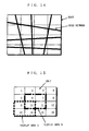
- Fig.5 shows rough maps for displaying three patterns of routes using the Tomei (Tokyo-Nagoya) Expressway, the Chuo (Central) Expressway, and the Hokuriku Expressway between Osaka and Tokyo.
- Fig.5(A) shows a rough map produced by extracting only the expressways related to the routes from among all roads.
- Fig.5(A) shows only the related road networks implements a simple and easy-to-understand display without complicated by unrelated small roads.
- Fig.5(B) shows a rough map showing the routes with their positional relations changed. The example shown in Fig.5(B) further improves the visibility of the user.
- the image data produced in the rough map producing portion 206 is stored into the storage medium 207 as the route data, together with link data for defining the correspondence between the image data and the road network data.
- a road network area used as an object of the route search on the starting side (hereinafter referred to as a starting point area) is determined.
- intersections of roads extending over the boundary of the starting point area and the boundary (hereinafter referred to as boundary points) are searched for.
- a road network area used as an object of the route search on the destination side (hereinafter referred to as a destination area) is determined and the boundary points of this destination area are searched for, as well.
- routes are searched for simultaneously starting from all of the boundary points of the starting point area to any of the boundary points of the destination area.
- the conditions in this search are variously changed depending on the needs required for the apparatus, e.g., minimum travel time conditions, minimum distance conditions, and the like.
- the plurality of obtained routes are stored corresponding to the combination of the starting point area and the destination area.
- the size of the road network areas subjected to the route search is changed depending on the distance between the starting point and the destination. That is to say, as shown in Fig.7(A), when the distance D between the central points in the starting point area and the destination area corresponds to a short distance shorter than a predetermined distance ⁇ (when D ⁇ ), the routes are searched for between the areas divided in the area dividing portion 204 shown in Fig.2.
- Fig.7(B) when the distance D between the central points in the starting point area and the destination area corresponds to an intermediate distance equal to or longer than the distance ⁇ and smaller than a predetermined distance ⁇ ( ⁇ > ⁇ ) (when ⁇ D ⁇ ), four areas are defined as one intermediate area, for example, and the routes are searched for between the two intermediate-distance areas.
- the distance D between the central points in the starting point area and the destination area corresponds to a long distance equal to or larger than the distance ⁇ (when D ⁇ ) as shown in Fig.7(c)
- 16 areas are defined as one long-distance area, for example, and the routes are searched for between the two long-distance areas.
- this route search can largely reduce the amount of the route data stored in the storage medium 207.
- Fig.7(B) when the routes to the road network areas N1-N4 on the destination side are obtained for each of the road network areas M1-M4 on the starting point side, 16 sets of route data are produced.
- Fig.11 is a flowchart showing the operation of the route searching apparatus shown in Fig.1. Referring to Fig.11, the operation of the route searching apparatus of Fig.1 will now be described.
- the user inputs a starting point and a destination by using the point input device 2 (steps S101, S102).
- the starting point instead of requiring the user to input, the present position of the vehicle may be automatically set as the starting point by separately using a function of detecting the present position of the vehicle, for example.
- the area investigating device 3 investigates the distance between the inputted starting point and destination to determine which of the predetermined short distance, intermediate distance and long distance the distance belongs to (steps S103, S105).
- the area investigating device 3 investigates to see to which road network areas the starting point and the destination belong, from the coordinates of the starting point and the destination (steps S104, S106, S107).
- the area investigating device 3 investigates the short-distance areas to which the starting point and the destination belong (step S104).
- step S106 When the distance D between the starting point and the destination corresponds to the intermediate distance equal to or larger than the distance ⁇ and smaller than the predetermined distance ⁇ ( ⁇ > ⁇ ) (when ⁇ D ⁇ ), it investigates the intermediate-distance areas to which the starting point and the destination belong (step S106). When the distance D between the starting point and the destination corresponds to the long distance equal to or larger than the distance ⁇ (when D ⁇ ), it investigates the long-distance areas to which the starting point and the destination belong (step S107).
- the route retrieving device 4 retrieves and reads route data corresponding to the combination from the route data storage device 1 (step S108). At this time, the route retrieving device 4 outputs the route data read from the route data storage device 1 to the route selection input device 5.
- the route selection input device 5 shows (displays) a rough map showing the routes between the corresponding road network areas to the user by using the output device 6 on the basis of the image data in the route data provided from the route retrieving device 4 (step S109). After that, the route selection input device 5 waits for the user to select one of the plurality of routes displayed. When the user has selected one of the plurality of routes, the route selection input device 5 determines the selected route as the final route.
- the peripheral route searching device 8 searches the road network areas obtained by the area investigating device 3 in the vicinities of the starting point and the destination outputted from the point input device 2 (step S110, S111). For example, as shown in Fig.9, the vicinity of the starting point is searched by reading the road network data contained in the starting point area from the road network data storage device 7 and searching for the shortest routes from the starting point to all of the boundary points of the starting point area. Similarly, starting from the destination, the shortest routes to the boundary points are searched for in the destination area.
- the peripheral route searching device 8 receives the above-mentioned final route from the route selection input device 5 (step S112). More specifically, the peripheral route searching device 8 receives, from the route selection input device 5, link data for relating the final route selected on the image data by the user to links or nodes on the road network data. Next, the peripheral route searching device 8 obtains the route (the peripheral route around the starting point) from the starting point to one end of the final route (i.e., a boundary point of the starting point area) from the results of the search performed before. Similarly, the peripheral route searching device 8 obtains the route (the peripheral route around the destination) from the other end of the final route (i.e., a boundary point of the destination area) to the destination from the results of the search performed before.
- the peripheral route searching device 8 unites the three routes (the peripheral route around the starting point, the final route, the peripheral route around the destination) into one as the route from the starting point to the destination (step S113) and shows the result to the user through the output device 6 (step S114).
- the point input device 2, the area investigating device 3, the route retrieving device 4, the route selection input device 5, the peripheral route searching device 8, the portion 202 for producing road network data for use in search, the area dividing portion 204, the two-area multiple route searching portion 205, and the rough map producing portion 206 may be all formed of hard circuits, or part or all of the functions may be realized with program processings of a computer.
- the software program may be supplied to the apparatus in the form of a recording medium such as a CD-ROM, a DVD, or a flexible disk, or may be supplied to the apparatus through a communication line.
- the peripheral route searching device 8 searches for the routes by using the Dijkstra method, but it may perform the route search by using another method.
- the road network data is read from the road network data storage device 7 before the search, the data may be read while searching, or the search may be made over the areas.
- the image data in the route data used for display is produced from the basic data, but a deformed map (e.g., a map drawn by a man) may be used, for example, and the route date may be stored with relating the image date thereto.
- a deformed map e.g., a map drawn by a man
- each of the intersections on the road network may be recorded with data indicating which of the road network areas it belongs to.
- the road network area can be specified by using the data recorded with a nearby intersection.
- the two-area multiple route searching portion 205 produces the route data by using all of the boundary points of the starting point area as the starting points of the search.
- the route data may be produced by using one point in the starting point area as a starting point, for example.
- the two-area multiple route searching portion 205 produces the route data by searching for routes between the boundary points.
- the route data may be produced by searching for routes between points near the boundary points (e.g., nodes which are the closest to the boundary points on the road network data).
- the route data are produced as shown in Fig.6(C) or Fig.6(D).
- the peripheral route searching device 8 it is necessary for the peripheral route searching device 8 to make a search to certain search conditions until at least the points near the boundary points are included (e.g., to a 10 km area in the case of a short-distance route).
- the peripheral route searching device 8 may obtain routes connected not to the ends of the selected route but to some points on the route and reconfigure them with the selected route as the route from the starting point to the destination.
- the image data for display are used as the route data.
- a map data storage device 9 may be separately provided for storing map data for displaying background.
- road specifying data for specifying roads corresponding to the individual routes on the map data may be used as the route data.
- the map data for displaying background as shown in Fig.13, the following two kinds of formats may be adopted, for example.
- the road specifying data in the route data specifies numbers of the bits existing on the routes.
- the road specifying data in the route data specifies numbers of the vectors along the routes.
- the map data is read from the map data storage device 9 only in portions required to make a display. Accordingly, as shown in Fig.14, the map data is stored in the map data storage device 9 in the form previously divided into certain coordinate units or into certain data size units. This storage unit is called "a unit.” When there are units as shown in Fig.15, the units related to the display area A and the display area B are read from the map data storage device 9 as follows.
- the map data storage device 9 stores the map data in the order of the unit numbers without overlap to reduce the amount of the stored data.
- the units 9, 10 and the units 13, 14 are stored in the separated locations (i.e., the units 11, 12 are interposed therebetween), it is necessary when displaying the display area A to read them by separate access operations.
- the units 6, 7 and the units 10, 11 must be read with different accessing operations.
- the units required to display routes between road network areas may be collected in advance and the collected units may be stored in successive locations. Then, when displaying the display area A, for example, the necessary units 9, 10, 13, 14 can be read by one access operation, since they are stored in the successive locations. This reduces the time required to read the map data.
- the overlapping units may be stored so that they can be shared in use, so as to reduce the amount of stored data.
- map data of units required to make a display may be previously reconfigured into one unit so that the map data can be read at once and the display can be made without considering boundaries between the units.
- the route retrieving device 4 searches the route data storage device 1 to read the route data (the road specifying data) corresponding to a combination of a starting point area and a destination area obtained in the area investigating device 3.
- the route selection input device 5 searches for and reads the units of the map data corresponding to the route data retrieved by the route retrieving device 4 from the map data storage device 9 and makes the output device 6 display the map data as a background.
- the route selection input device 5 displays the routes on the roads specified by the route data (road specifying data) retrieved by the route retrieving device 4.
Landscapes
- Engineering & Computer Science (AREA)
- Radar, Positioning & Navigation (AREA)
- Remote Sensing (AREA)
- Physics & Mathematics (AREA)
- General Physics & Mathematics (AREA)
- Automation & Control Theory (AREA)
- Navigation (AREA)
- Instructional Devices (AREA)
- Traffic Control Systems (AREA)
Claims (17)
- Ein Verfahren zum Suchen einer optimalen Route zwischen zwei beliebig angegebenen Punkten in bestimmten Straßennetz-Daten (203, 7), umfassend:einen ersten Schritt (204) des Einteilens besagter Straßennetz-Daten (203, 7) in eine Vielzahl von Straßennetz-Flächen (Fig. 4), gekennzeichnet durch einen zweiten Schritt (205) des im Voraus Erhaltens von Routen zwischen zwei beliebigen Straßennetz-Flächen für alle der Straßennetz-Flächen, welche im ersten Schritt eingeteilt wurden und des Aufzeichnens der ermittelten Routen als Routendaten in einem Medium zum Aufzeichnen von Routen (207, 1);einem dritten Schritt (3) des Untersuchens, wenn ein Startpunkt und ein Ziel angegeben sind (2), um zwei Straßennetz-Flächen zu erhalten, zu welchen die einzelnen Punkte gehören;einem vierten Schritt (4) des wieder Auffindens der Routendaten, welche zu der Kombination von zwei Straßennetz-Flächen gehören, welche im dritten Schritt erhalten wurden, aus dem Medium zum Speichern von Routen (207, 1); undeinem fünften Schritt (8, 6) des Suchens nach einer Route von dem Startpunkt zum Ziel auf der Basis der Routendaten, die wieder aufgefunden wurden im vierten Schritt und des Vorschlagens der Route für einen Benutzer.
- Das Verfahren zum Suchen von Routen gemäß Anspruch 1 weiter umfassend einen sechsten Schritt des vorherigen Erzeugens von Landkartendaten (Fig. 13A) zur Anzeige eines Hintergrunds und zum Aufzeichnen der Landkartendaten (Fig. 13A) in einem Medium zum Aufzeichnen von Landkarten (9),
wobei im fünften Schritt (8, 6) die Landkartendaten (Fig. 13A), welche den Routendaten entsprechen, die im vierten Schritt wieder aufgefunden wurden, gelesen werden vom Medium zum Aufzeichnen von Landkarten (9) und angezeigt werden und die gesuchte Route angezeigt wird über den angezeigten Landkartendaten (Fig. 13A). - Verfahren zum Suchen von Routen gemäß Anspruch 2, wobei die Routendaten, welche in dem Medium zum Aufzeichnen von Routen (207, 1) aufgezeichnet wurden, Daten zum Bestimmen von Straßen umfassen, zum Bestimmen einer Straße, die zu jeder Route in den Landkartendaten (Fig. 13A) gehört,
wobei im fünften Schritt (8, 6) die gesuchte Route über der Straße in besagten Landkartendaten (Fig. 13A), welche durch die Daten zur Bestimmung von Straßen bestimmt wird, angezeigt wird. - Verfahren zum Suchen von Routen gemäß Anspruch 2, wolbei die Routendaten, die in dem Medium zum Aufzeichnen von Routen (207, 1) aufgezeichnet wurden, Bild-Daten umfassen (Fig. 5A - 5B, Fig. 8) zum Anzeigen von Routen, wobei im fünften Schritt (8, 6) die Bild-Daten (Fig. 5A - 5B, Fig. 8) über den Landkartendaten (Fig. 13A) angezeigt werden.
- Verfahren zum Suchen von Routen nach Anspruch 2, wobei die Landkartendaten (Fig. 13A) erzeugt werden (206) durch Extrahieren von Straßen, die zu den Routen zwischen Straßennetz-Flächen (Fig. 4) gehören, die im zweiten Schritt (205) erhalten wurden und zu den bezogenen Straßen von den Straßennetz-Daten (203).
- Verfahren zum Suchen von Routen nach Anspruch 2, wobei in den Landkartendaten (Fig. 13A) eine Vielzahl von teilweisen Landkartendaten (Fig. 16A), die benötigt werden, wenn eine Route zwischen zwei Straßennetz-Flächen angezeigt wird, im Voraus zusammengefasst werden (Fig. 16B - 16D) für jede Kombination von Straßennetz-Flächen, und die Vielzahl von zusammengefassten teilweisen Landkartendaten (Fig. 16B - 16D) aufgezeichnet werden im Medium zum Aufzeichnen von Landkarten (9) auf eine untereinander bezogene Art, so dass die Daten in einer einzigen Zugriffsoperation gelesen werden können.
- Verfahren zum Suchen von Routen nach Anspruch 1, wobei die Routendaten, die im Medium zum Aufzeichnen von Routen (207, 1) Bild-Daten umfassen, um die Routen bzw. eine Landkarte, die einen Hintergrund bildet, anzuzeigen und
im fünften Schritt (8, 6) die Bild-Daten (Fig. 5A - 5B, Fig. 8) in den Routendaten, die im vierten Schritt (4) wieder aufgefunden wurden, angezeigt werden, wie sie sind. - Verfahren zum Suchen von Routen gemäß Anspruch 1, wobei der fünfte Schritt (8, 6) umfasst,einen achten Schritt (S110) des Suchens in der näheren Umgebung des Startpunktes nach einer ersten verbindenden Route vom Startpunkt zu der Route in den Routendaten, die im vierten Schritt (4) wieder aufgefunden wurde, auf der Basis der Straßennetz-Daten (203, 7),einem neunten Schritt (S111) des Suchens in der Nähe des Ziels nach einer zweiten verbindenden Route vom Ziel zu der Route in den Routendaten, welche im vierten Schritt auf der Basis der Straßennetz-Daten (203, 7) wieder aufgefunden wurde, einen zehnten Schritt (S113) des Erzeugens der gesamten Route vom Startpunkt zum Ziel unter Benutzung der ersten und zweiten verbindenden Routen, die in den achten und neunten Schritten (S110, S111) gesucht wurden und der Route in den Routendaten, die im vierten Schritt (4) wieder aufgefunden wurde, undeinem elften Schritt (114) des Anzeigens der gesamten Route, die im zehnten Schritt erzeugt wurde.
- Verfahren zum Suchen von Routen nach Anspruch 8, wobei die Routendaten, die in dem Medium zum Aufzeichnen von Routen (207, 1) aufgezeichnet wurden, weiter Information umfassen über einen Randpunkt (Fig. 6A) an dem jede Route eine Straßennetz-Flächen (Fig. 4) schneidet,wobei im achten Schritt (S110), Routen gesucht werden vom Startpunkt zu allen Randpunkten der Straßennetz-Fläche, zu dem der Startpunkt gehört (Fig. 9),im neunten Schritt (S111), Routen gesucht werden vom Ziel zu allen Randpunkten der Straßennetz-Flächen, zu welcher das Ziel gehört.
- Verfahren zum Suchen von Routen nach Anspruch 1, wobei im zweiten Schritt (205) eine oder eine Vielzahl von Routen erhalten wird zwischen den Straßennetz-Flächen (Fig. 4) und die erhaltenen Routen aufgezeichnet werden als Routendaten im Medium zum Aufzeichnen von Routen (107, 1), undder fünfte Schritt (8, 6) beinhaltet,einen zwölften Schritt (S109, 5) der Anzeige von einer oder einer Vielzahl von Routen auf der Basis der Routendaten, welche im vierten Schritt (4) wieder aufgefunden wurden, undeinen dreizehnten Schritt (S112, 5) des Auswählens einer von einer Vielzahl von Routen in Erwiderung einer Benutzerhandlung, wenn eine Vielzahl von Routen angezeigt werden im zwölften Schritt (S109, 5).
- Verfahren zum Suchen von Routen nach Anspruch 10, wobei der fünfte Schritt (8, 6) weiter umfasst,einen vierzehnten Schritt der Suche nach einer ersten verbindenden Route vom Startpunkt zu der Route, die im dreizehnten Schritt (S112, 5) in der näheren Umgebung des Startpunktes auf der Basis der Straßennetz-Daten (203, 7) ausgewählt wurden,einen fünfzehnten Schritt des Suchens nach einer zweiten verbindenden Route vom Ziel zu der Route, die im dreizehnten Schritt (S112, 5) in der unmittelbaren Nähe des Ziels auf der Basis der Straßennetz-Daten (203, 7) ausgewählt wurden, undeinen sechzehnten Schritt der Erzeugung der gesamten Route vom Startpunkt zum Ziel unter Benutzung der ersten und zweiten verbindenden Routen, die in den vierzehnten und fünfzehnten Schritten gesucht wurden und der Route, die im dreizehnten Schritt (S112, 5) ausgewählt wurde.
- Verfahren zum Suchen von Routen nach Anspruch 11, wobei die Routendaten in dem Medium zum Aufzeichnen von Routen (207, 1) weiter Information umfassen über einen Randpunkt (Fig. 6A), an dem jede Route eine Straßennetz-Fläche (Fig. 4) schneidet,wobei der vierzehnte Schritt einen siebzehnten Schritt (Fig. 9) umfasst des Suchens von Routen vom Startpunkt zu allen Randpunkten (Fig. 6A) des Straßennetzwerkes (Fig. 4), zu welchem der Startpunkt gehört, undder fünfzehnte Schritt einen achtzehnten Schritt umfasst des Suchens nach Routen vom Ziel zu allen Randpunkten (Fig. 6A) des Straßennetzwerkes (Fig. 4), zu welchem das Ziel gehört.
- Verfahren zum Suchen von Routen nach Anspruch 12, wobei die siebzehnten und achtzehnten Schritte durchgeführt werden, während dem der Benutzer eine Route auswählt (Fig. 8) aus einer Vielzahl von in dem dreizehnten Schritt (S112, 5) angezeigten Routen.
- Verfahren zum Suchen von Routen nach Anspruch 1, wobei der erste Schritt (204) umfasst,einen neunzehnten Schritt des Einteilens der Straßennetz-Daten (203) in Straßennetz-Flächen minimaler Einheiten (M1 - 4, N1 - 4), undeinem zwanzigsten Schritt des Einteilens der Straßennetz-Daten (203) in Straßennetz-Flächen kollektiver Einheiten (M, N), von denen jede eine Vielzahl minimaler Einheiten (M1 - 4, N1 - 4) enthält, undder zweite Schritt (205) umfasst,einen einundzwanzigsten Schritt des Suchens nach zwei der Straßennetz-Flächen minimaler Einheiten als Ziel (M3, N2),einen zweiundzwanzigsten Schritt (Fig. 7A) des Erhaltens einer Route, wenn der Abstand zwischen den Straßennetz-Flächen von minimaler Einheit (M3, N2), die im einundzwanzigsten Schritt gesucht wird, kürzer als ein vorbestimmter Abstand ist, von einer Route zwischen den durchsuchten Straßennetz-Flächen von minimaler Einheit (M3, N2) und des Aufzeichnens der ermittelten Route als Routendaten im Medium zum Aufzeichnen von Routen (207, 1), undeinen dreiundzwanzigsten Schritt (Fig. 7B - C) des Erhaltens einer Route, wenn die Entfernung zwischen den Straßennetz-Flächen von minimaler Einheit (M3, N2), die im einundzwanzigsten Schritt gesucht wurde, länger als ein vorbestimmter Abstand ist, zwischen den Straßennetz-Flächen von kollektiver Einheit (M, N), zu welchen die durchsuchten Straßennetz-Flächen von minimaler Einheit (M3, N2) gehören und des Aufzeichnens der erhaltenen Route als Routendaten im Medium zum Aufzeichnen von Routen (107, 1),wobei die einundzwanzigsten bis dreiundzwanzigsten Schritte wiederholt durchgeführt werden, wobei der dritte Schritt (3) umfasst,einen vierundzwanzigsten Schritt (S104) des Untersuchens, wenn der Abstand zwischen dem angegebenen Startpunkt und dem Ziel kürzer als ein vorgegebener Abstand ist, um die Straßennetz-Flächen von minimaler Einheit (M3, N2) zu erhalten, zu welchen die einzelnen Punkte gehören, undeinem fünfundzwanzigsten Schritt des Untersuchens (S106, S107), wenn der Abstand zwischen dem angegebenen Startpunkt und dem Ziel größer als ein vorgegebener Abstand ist, um die Straßennetz-Flächen von kollektiver Einheit (M, N) zu erhalten, zu welchen die einzelnen Punkte gehören.
- Vorrichtung zum Suchen einer optimalen Route zwischen zwei beliebig angegebenen Punkten in bestimmten Straßennetz-Daten (203, 7),wobei besagte Straßennetz-Daten (203, 7) in eine Vielzahl von Straßennetz-Flächen (Fig. 4) aufgeteilt sind, dadurch gekennzeichnet, dassStraßen zwischen zwei beliebigen Straßennetz-Flächen im Voraus erhalten werden für jede Straßennetz-Fläche (Fig. 4), wobei die Vorrichtung zum Suchen von Routen umfasst,ein Teil zum Speichern von Routen (207, 1) zum Speichern von Routen, die erhalten wurden zwischen den Straßennetz-Flächen (Fig. 4) als Routendaten,ein Teil zum Untersuchen von Flächen (3) zum Suchen von zwei der Straβennetz-Flächen (Fig. 4), zu welchen die einzelnen Punkte gehören, wenn eine Route von einem bestimmten Startpunkt zu einem Ziel gesucht wird,ein Teil zum wieder Auffinden einer Route (4) zum wieder Auffinden aus dem Teil zum Speichern von Routen (207, 1) der Routendaten, die zu der Kombination gehören von zwei Straßennetz-Flächen, die in dem Teil zum Untersuchen von Flächen (3) erhalten wurden, undein Teil zum Vorschlagen von Routen (8, 6) zum Suchen nach einer Route von dem Startpunkt zum Ziel auf der Basis der Routendaten, die in dem Teil zum wieder Auffinden von Routen (4) wieder aufgefunden wurden, um sie einem Benutzer vorzuschlagen.
- Vorrichtung zum Suchen nach einer optimalen Route zwischen zwei beliebig angegebenen Punkten in bestimmten Straßennetz-Daten (203, 7),wobei die Straßennetz-Daten (203, 7) im Voraus eingeteilt wurden in eine Vielzahl von Straßennetz-Flächen (Fig. 4), dadurch gekennzeichnet, dassRouten zwischen einzelnen Straßennetz-Flächen (Fig. 4) im Voraus gesucht wurden undwobei, wenn ein Startpunkt und ein Ziel angegeben werden (2), eine Route zwischen zwei der Straßennetz-Flächen, zu welchen die einzelnen Punkte gehören, ermittelt wird (3, 4) aus den vorher durchsuchten Ergebnissen (207, 19 und Routen zwischen dem Startpunkt und dem Ziel und der ermittelten Route zwischen den Straßennetz-Flächen interpoliert werden (8, S113), in dem eine Suche durchgeführt wird auf der Basis der Straßennetz-Daten (203, 7).
- Aufzeichnungsmedium mit einem darauf aufgezeichneten Computerlesbaren Programm zum Suchen nach einer optimalen Route zwischen zwei beliebig angegebenen Punkten in bestimmten Straßennetz-Daten (203, 7),wobei die Straßennetz-Daten (203, 7) im Voraus eingeteilt wurden in eine Vielzahl von Straßennetz-Flächen (Fig. 4) dadurch gekennzeichnet, dassRouten zwischen Straßennetz-Flächen (Fig. 4) im Voraus gesucht wurden undwobei das Programm umfasst,einen ersten Programmschritt (3, 4) des Ermitteins einer Route, wenn ein Startpunkt und ein Ziel angegeben werden (2) zwischen zwei der Straßennetz-Flächen, zu welchen die einzelnen Punkte gehören aus vorher durchsuchten Ergebnissen (207, 1), undeinem zweiten Programmschritt (8, S113) des Interpolierens der Intervalle zwischen dem Startpunkt und dem Ziel und der Route zwischen den Straßennetz-Flächen, die im ersten Programmschritt (3, 4) erhalten wurden, in dem eine Suche durchgeführt wird auf der Basis der Straßennetz-Daten (203, 7).
Applications Claiming Priority (3)
| Application Number | Priority Date | Filing Date | Title |
|---|---|---|---|
| JP259747/96 | 1996-09-30 | ||
| JP25974796A JP3446930B2 (ja) | 1996-09-30 | 1996-09-30 | 経路選出方法および経路選出装置 |
| JP25974796 | 1996-09-30 |
Publications (2)
| Publication Number | Publication Date |
|---|---|
| EP0833290A1 EP0833290A1 (de) | 1998-04-01 |
| EP0833290B1 true EP0833290B1 (de) | 2002-04-10 |
Family
ID=17338395
Family Applications (1)
| Application Number | Title | Priority Date | Filing Date |
|---|---|---|---|
| EP97116785A Expired - Lifetime EP0833290B1 (de) | 1996-09-30 | 1997-09-26 | Verfahren und Gerät zum Berechnen einer Route |
Country Status (5)
| Country | Link |
|---|---|
| US (1) | US6014607A (de) |
| EP (1) | EP0833290B1 (de) |
| JP (1) | JP3446930B2 (de) |
| KR (1) | KR100279760B1 (de) |
| DE (1) | DE69711795T2 (de) |
Cited By (1)
| Publication number | Priority date | Publication date | Assignee | Title |
|---|---|---|---|---|
| EP2639553A1 (de) * | 2012-03-15 | 2013-09-18 | Fujitsu Limited | Pfadsuchverfahren und Pfadsuchvorrichtung |
Families Citing this family (91)
| Publication number | Priority date | Publication date | Assignee | Title |
|---|---|---|---|---|
| US6636733B1 (en) * | 1997-09-19 | 2003-10-21 | Thompson Trust | Wireless messaging method |
| EP1025423B1 (de) * | 1997-10-21 | 2001-11-21 | Siemens Aktiengesellschaft | Verfahren und anordnung zur ermittlung einer route von einem startpunkt zu einem zielpunkt |
| DE19754786A1 (de) * | 1997-12-10 | 1999-06-17 | Cit Alcatel | Verfahren zur Vorgabe von Positionsdaten |
| JP3473398B2 (ja) * | 1998-05-01 | 2003-12-02 | 株式会社日立製作所 | 地図応用システムおよび地図表示制御方法 |
| JP4019528B2 (ja) * | 1998-11-20 | 2007-12-12 | ソニー株式会社 | ナビゲーション装置および方法、並びに提供媒体 |
| WO2000031663A1 (en) * | 1998-11-24 | 2000-06-02 | Matsushita Electric Industrial Co., Ltd. | Data structure of digital map file |
| JP2000161970A (ja) * | 1998-11-27 | 2000-06-16 | Alpine Electronics Inc | 車載用ナビゲーション装置の渋滞情報簡易表示方法 |
| EP1182611A4 (de) * | 1999-01-25 | 2003-04-02 | Kabushiki Kaisya Zenrin | Verfahren und vorrichtung zur erzeugung und verwendung von polygondaten innerhalb einer strassenkarte |
| US6463400B1 (en) * | 1999-02-01 | 2002-10-08 | Tele Atlas North America Inc | Quarter sectioning algorithm |
| JP3654048B2 (ja) * | 1999-05-20 | 2005-06-02 | 日産自動車株式会社 | ハイブリッド車両の駆動制御装置 |
| JP4080649B2 (ja) * | 1999-09-20 | 2008-04-23 | パイオニア株式会社 | 人ナビゲーションシステム |
| KR100678307B1 (ko) * | 1999-12-18 | 2007-02-01 | 주식회사 케이티 | 제약 조건을 적용한 최적경로 산정 방법 |
| US8060389B2 (en) * | 2000-06-07 | 2011-11-15 | Apple Inc. | System and method for anonymous location based services |
| US8073565B2 (en) * | 2000-06-07 | 2011-12-06 | Apple Inc. | System and method for alerting a first mobile data processing system nearby a second mobile data processing system |
| US6456234B1 (en) | 2000-06-07 | 2002-09-24 | William J. Johnson | System and method for proactive content delivery by situation location |
| JP3504918B2 (ja) * | 2000-10-19 | 2004-03-08 | 株式会社エヌ・ティ・ティ・データ | 略地図生成システム及び略地図生成方法 |
| US6751548B2 (en) * | 2000-11-20 | 2004-06-15 | Max Fox | Matching stored routes to a required route |
| DE60134210D1 (de) * | 2000-12-27 | 2008-07-10 | Fujifilm Corp | System und Verfahren zur Informationsbenachrichtigung |
| AU2002250186A1 (en) * | 2001-02-26 | 2002-09-12 | Alk Technologies, Inc. | Thin-client navigation and route guidance system |
| JP2002286473A (ja) * | 2001-03-22 | 2002-10-03 | Auto Network Gijutsu Kenkyusho:Kk | 推奨経路計算方法 |
| US6701251B2 (en) * | 2001-04-18 | 2004-03-02 | General Motors Corporation | Method and system for providing multiple beginning maneuvers for navigation of a vehicle |
| US7487252B2 (en) * | 2001-11-16 | 2009-02-03 | Gateway Inc. | Vehicle based intelligent network interactivity |
| JP4004818B2 (ja) * | 2002-02-28 | 2007-11-07 | 松下電器産業株式会社 | 位置情報伝達装置及び方法 |
| US7613331B2 (en) | 2003-01-22 | 2009-11-03 | Increment P Corporation | Recording medium storing map information, map information processing device, map information processing system, map information processing method, map information processing program and recording medium storing the map information processing program |
| TW588292B (en) * | 2003-02-21 | 2004-05-21 | Sin Etke Technology Co Ltd | Simplified navigation guidance method and system thereof |
| JP2005127725A (ja) * | 2003-10-21 | 2005-05-19 | Navitime Japan Co Ltd | ナビゲーション装置、ナビゲーション方法およびプログラム |
| US20050165629A1 (en) * | 2004-01-28 | 2005-07-28 | Bruns Arno D. | Systems and methods for planning the delivery of goods |
| JP4603332B2 (ja) * | 2004-10-18 | 2010-12-22 | クラリオン株式会社 | 要約地図作成装置 |
| DE102005004635A1 (de) * | 2005-02-01 | 2006-08-10 | Siemens Ag | System zur abschnittsweisen Bestimmung einer Route |
| US7353034B2 (en) | 2005-04-04 | 2008-04-01 | X One, Inc. | Location sharing and tracking using mobile phones or other wireless devices |
| KR100705213B1 (ko) * | 2005-04-08 | 2007-04-06 | 주식회사 현대오토넷 | 네비게이션시스템의 경로 선택 방법 |
| DE102005021271B3 (de) * | 2005-05-09 | 2006-12-07 | Siemens Ag | Verfahren zur Berechnung einer Route in einem Navigationssystem |
| US8131415B2 (en) * | 2005-05-24 | 2012-03-06 | Trimble Navigation, Ltd | Method and apparatus for automatic vehicle guidance using continuous 2-D poly-point path |
| US7715980B2 (en) * | 2005-11-17 | 2010-05-11 | Microsoft Corporation | Schematic destination maps |
| KR100791748B1 (ko) * | 2005-11-28 | 2008-01-04 | 유영근 | 탐색영역 제한 방법과 최소 기대 소요값을 구하는 방법 및최단경로 탐색방법 |
| FI119006B (fi) * | 2006-01-03 | 2008-06-13 | Navicore Oy | Kaksivaiheinen reititysproseduuri |
| JP5116236B2 (ja) * | 2006-01-30 | 2013-01-09 | アルパイン株式会社 | 地図データ作成方法及び地図データ作成装置 |
| KR100765126B1 (ko) * | 2006-04-05 | 2007-10-11 | 팅크웨어(주) | 2-pass방식의 경로 탐색 방법 및 상기 방법을수행하는 시스템 |
| JP5013738B2 (ja) * | 2006-04-25 | 2012-08-29 | アルパイン株式会社 | 地図データ作成装置 |
| JP5364967B2 (ja) * | 2006-05-02 | 2013-12-11 | 日産自動車株式会社 | 地図データ処理装置、地図データ処理方法および地図データ処理システム |
| KR100829837B1 (ko) * | 2006-11-23 | 2008-05-19 | 주식회사 현대오토넷 | 미리 탐색된 지도 데이터를 이용한 경로 탐색 방법 |
| US20080167083A1 (en) * | 2007-01-07 | 2008-07-10 | Wyld Jeremy A | Method, Device, and Graphical User Interface for Location-Based Dialing |
| CN101595367B (zh) * | 2007-01-31 | 2013-12-11 | 三菱电机株式会社 | 导航装置 |
| US8229458B2 (en) | 2007-04-08 | 2012-07-24 | Enhanced Geographic Llc | Systems and methods to determine the name of a location visited by a user of a wireless device |
| JP4882881B2 (ja) * | 2007-06-13 | 2012-02-22 | 株式会社デンソー | 車載ナビゲーション装置 |
| JP4997597B2 (ja) * | 2007-06-15 | 2012-08-08 | 国立大学法人東京海洋大学 | 最短経路探索方法 |
| US8180379B2 (en) | 2007-06-28 | 2012-05-15 | Apple Inc. | Synchronizing mobile and vehicle devices |
| US9109904B2 (en) * | 2007-06-28 | 2015-08-18 | Apple Inc. | Integration of map services and user applications in a mobile device |
| US8311526B2 (en) | 2007-06-28 | 2012-11-13 | Apple Inc. | Location-based categorical information services |
| US8204684B2 (en) * | 2007-06-28 | 2012-06-19 | Apple Inc. | Adaptive mobile device navigation |
| US8385946B2 (en) | 2007-06-28 | 2013-02-26 | Apple Inc. | Disfavored route progressions or locations |
| US8290513B2 (en) | 2007-06-28 | 2012-10-16 | Apple Inc. | Location-based services |
| US8108144B2 (en) | 2007-06-28 | 2012-01-31 | Apple Inc. | Location based tracking |
| US8762056B2 (en) * | 2007-06-28 | 2014-06-24 | Apple Inc. | Route reference |
| US8774825B2 (en) | 2007-06-28 | 2014-07-08 | Apple Inc. | Integration of map services with user applications in a mobile device |
| US8275352B2 (en) | 2007-06-28 | 2012-09-25 | Apple Inc. | Location-based emergency information |
| US9066199B2 (en) | 2007-06-28 | 2015-06-23 | Apple Inc. | Location-aware mobile device |
| US8175802B2 (en) * | 2007-06-28 | 2012-05-08 | Apple Inc. | Adaptive route guidance based on preferences |
| US20090005964A1 (en) * | 2007-06-28 | 2009-01-01 | Apple Inc. | Intelligent Route Guidance |
| US8332402B2 (en) | 2007-06-28 | 2012-12-11 | Apple Inc. | Location based media items |
| JP2009042101A (ja) * | 2007-08-09 | 2009-02-26 | Funai Electric Co Ltd | ナビゲーション装置 |
| US20090063032A1 (en) * | 2007-08-30 | 2009-03-05 | Honeywell International, Inc. | Methods, systems, and apparatus for routing a vehicle to avoid an adverse condition |
| US8727049B1 (en) | 2007-11-07 | 2014-05-20 | Marvell International Ltd. | Efficient hybrid vehicle |
| US8355862B2 (en) * | 2008-01-06 | 2013-01-15 | Apple Inc. | Graphical user interface for presenting location information |
| US20090326815A1 (en) * | 2008-05-02 | 2009-12-31 | Apple Inc. | Position Fix Indicator |
| US9250092B2 (en) | 2008-05-12 | 2016-02-02 | Apple Inc. | Map service with network-based query for search |
| US8644843B2 (en) * | 2008-05-16 | 2014-02-04 | Apple Inc. | Location determination |
| KR101019691B1 (ko) * | 2008-06-27 | 2011-03-07 | (주)엠앤소프트 | 출발지와 목적지 정보를 활용한 경로 탐색 방법 |
| US8369867B2 (en) * | 2008-06-30 | 2013-02-05 | Apple Inc. | Location sharing |
| US8359643B2 (en) * | 2008-09-18 | 2013-01-22 | Apple Inc. | Group formation using anonymous broadcast information |
| US8260320B2 (en) * | 2008-11-13 | 2012-09-04 | Apple Inc. | Location specific content |
| US8219316B2 (en) * | 2008-11-14 | 2012-07-10 | Google Inc. | System and method for storing and providing routes |
| US8666367B2 (en) | 2009-05-01 | 2014-03-04 | Apple Inc. | Remotely locating and commanding a mobile device |
| US8670748B2 (en) * | 2009-05-01 | 2014-03-11 | Apple Inc. | Remotely locating and commanding a mobile device |
| US8660530B2 (en) | 2009-05-01 | 2014-02-25 | Apple Inc. | Remotely receiving and communicating commands to a mobile device for execution by the mobile device |
| US9183249B2 (en) | 2009-05-15 | 2015-11-10 | Hyundai Motor Company | Apparatus and method for generating a path |
| KR101123274B1 (ko) | 2010-02-26 | 2012-03-20 | 현대엠엔소프트 주식회사 | 링크 분할을 통한 경로 탐색 방법 및 경로 재탐색 방법 |
| DE102010040587A1 (de) * | 2010-09-10 | 2012-03-15 | Bayerische Motoren Werke Aktiengesellschaft | Navigationssystem und Verfahren zum Berechnen von Gesamtkosten einer Route |
| US8566030B1 (en) | 2011-05-03 | 2013-10-22 | University Of Southern California | Efficient K-nearest neighbor search in time-dependent spatial networks |
| US8660789B2 (en) * | 2011-05-03 | 2014-02-25 | University Of Southern California | Hierarchical and exact fastest path computation in time-dependent spatial networks |
| KR101316262B1 (ko) | 2012-01-20 | 2013-10-08 | 현대자동차주식회사 | Soi 기반의 경로 생성 장치 및 그 방법 |
| US9791280B2 (en) * | 2012-12-21 | 2017-10-17 | Google Inc. | Determining a route |
| JP5928392B2 (ja) * | 2013-03-28 | 2016-06-01 | アイシン・エィ・ダブリュ株式会社 | ルート探索システム、ルート探索方法、及びルート探索プログラム |
| US10126913B1 (en) * | 2013-11-05 | 2018-11-13 | Google Llc | Interactive digital map including context-based photographic imagery |
| JP6359286B2 (ja) * | 2014-02-20 | 2018-07-18 | 株式会社ゼンリン | 経路探索装置 |
| JP6231405B2 (ja) * | 2014-02-28 | 2017-11-15 | 株式会社ゼンリン | 経路探索装置および経路探索方法 |
| BR112016021015B1 (pt) * | 2014-03-12 | 2022-04-26 | Nissan Motor Co. Ltd | Dispositivo de operação de veículo utilizado em um veículo autônomo controlado de maneira autônoma para conduzir ao longo de uma rota de condução determinada e método de operação de veículo para um veículo autônomo controlado de maneira autônoma para conduzir ao longo de uma rota de condução determinada |
| JP6536064B2 (ja) * | 2015-02-10 | 2019-07-03 | 株式会社デンソー | 走行軌跡選定装置、走行軌跡選定方法 |
| KR102576345B1 (ko) * | 2016-11-16 | 2023-09-08 | 삼성전자 주식회사 | 전자 장치의 위치 이동 방법 및 이를 사용하는 전자 장치 |
| US11361361B2 (en) * | 2018-02-20 | 2022-06-14 | Grzegorz Malewicz | Method and an apparatus for searching or comparing sites using routes or route lengths between sites and places within a transportation system |
| US11346681B2 (en) * | 2019-02-13 | 2022-05-31 | Grzegorz Malewicz | Method and an apparatus for searching or comparing sites using routes or route lengths between sites and places within a transportation system |
Family Cites Families (14)
| Publication number | Priority date | Publication date | Assignee | Title |
|---|---|---|---|---|
| JPS59105113A (ja) * | 1982-12-08 | 1984-06-18 | Agency Of Ind Science & Technol | 車両の自動誘導方法 |
| EP0246452A3 (en) * | 1986-04-24 | 1989-01-18 | Norda S.P.A. | Computerized trip planner and automotive navigator |
| EP0261450B1 (de) * | 1986-09-03 | 1991-07-24 | Siemens Aktiengesellschaft | Leitsystem für den Individualverkehr |
| DE3719017A1 (de) * | 1987-06-06 | 1988-12-15 | Bosch Gmbh Robert | Verfahren und vorrichtung zur bestimmung einer fahrtroute zwischen einem startpunkt und einem zielpunkt |
| NL8702014A (nl) * | 1987-08-28 | 1989-03-16 | Philips Nv | Routebepalingseenheid. |
| JP2637446B2 (ja) * | 1987-12-28 | 1997-08-06 | アイシン・エィ・ダブリュ株式会社 | ナビゲーション装置 |
| JP2653847B2 (ja) * | 1988-08-22 | 1997-09-17 | アイシン・エィ・ダブリュ株式会社 | ナビゲーション装置及びそのルート探索方法 |
| JPH0354590A (ja) * | 1989-04-18 | 1991-03-08 | Sanyo Electric Co Ltd | 経路探索方法 |
| JP2707834B2 (ja) * | 1990-11-29 | 1998-02-04 | 三菱電機株式会社 | 車両用経路案内装置 |
| JP2874397B2 (ja) * | 1991-03-19 | 1999-03-24 | 松下電器産業株式会社 | 経路選出装置 |
| JP3027899B2 (ja) * | 1993-05-12 | 2000-04-04 | 松下電器産業株式会社 | 推奨経路案内装置 |
| JP3203399B2 (ja) * | 1993-05-13 | 2001-08-27 | 松下電器産業株式会社 | 経路探索装置 |
| JPH0727568A (ja) * | 1993-07-09 | 1995-01-27 | Zanabui Informatics:Kk | 経路誘導装置および経路探索方法 |
| JP3223782B2 (ja) * | 1996-02-08 | 2001-10-29 | 三菱電機株式会社 | 車両経路算出装置 |
-
1996
- 1996-09-30 JP JP25974796A patent/JP3446930B2/ja not_active Expired - Fee Related
-
1997
- 1997-09-25 US US08/936,914 patent/US6014607A/en not_active Expired - Fee Related
- 1997-09-26 DE DE69711795T patent/DE69711795T2/de not_active Expired - Lifetime
- 1997-09-26 EP EP97116785A patent/EP0833290B1/de not_active Expired - Lifetime
- 1997-09-29 KR KR1019970051068A patent/KR100279760B1/ko not_active Expired - Fee Related
Cited By (1)
| Publication number | Priority date | Publication date | Assignee | Title |
|---|---|---|---|---|
| EP2639553A1 (de) * | 2012-03-15 | 2013-09-18 | Fujitsu Limited | Pfadsuchverfahren und Pfadsuchvorrichtung |
Also Published As
| Publication number | Publication date |
|---|---|
| EP0833290A1 (de) | 1998-04-01 |
| JP3446930B2 (ja) | 2003-09-16 |
| US6014607A (en) | 2000-01-11 |
| DE69711795T2 (de) | 2002-10-02 |
| DE69711795D1 (de) | 2002-05-16 |
| KR100279760B1 (ko) | 2001-02-01 |
| JPH10103991A (ja) | 1998-04-24 |
| KR19980025175A (ko) | 1998-07-06 |
Similar Documents
| Publication | Publication Date | Title |
|---|---|---|
| EP0833290B1 (de) | Verfahren und Gerät zum Berechnen einer Route | |
| EP0782120B1 (de) | Verfahren und Gerät zum Berechnen einer Route | |
| JP3803629B2 (ja) | 地図データ送信方法、情報配信装置、および情報端末 | |
| JP3223782B2 (ja) | 車両経路算出装置 | |
| US7526492B2 (en) | Data structure of map data, map data storage medium, map data updating method and map data processing apparatus | |
| EP0702208B1 (de) | Verfahren und System zur Routenauswahl | |
| JP4087678B2 (ja) | 地図データ送信方法 | |
| KR100279761B1 (ko) | 경로 탐색 장치 | |
| US5513110A (en) | Navigation system and path search method using hierarchized road data | |
| EP0820046A2 (de) | Gerät zur Gewinnung von Strassennetzzonendaten aus den Blockdaten einer Strassennetzkarte, System zum Umformen dieser Daten und Darstellung einer umgeformten Karte und geographisches Informationssystem | |
| JP2917825B2 (ja) | 経路選出方法およびシステム | |
| JP3923848B2 (ja) | ナビゲーション装置 | |
| JP3415040B2 (ja) | 旅行ルート作成システム及びプログラムを記録したコンピュータ可読媒体 | |
| JP2010054754A (ja) | 地図データのデータ構造 | |
| JP3221239B2 (ja) | 経路探索装置 | |
| JPH11248474A (ja) | 経路選出方法 | |
| JP3390342B2 (ja) | 経路探索装置 | |
| JP3386273B2 (ja) | 経路選出方法およびシステム | |
| JP3773015B2 (ja) | 地図描画用データ作成方法及びナビゲーション装置 | |
| JPH09318374A (ja) | ナビゲーション装置 | |
| JPH08136276A (ja) | 経路選出システム | |
| JP3798865B2 (ja) | 経路探索装置 | |
| JP3774284B2 (ja) | 経路探索装置 | |
| JP2878878B2 (ja) | 車載ナビゲータ | |
| JPH0816990A (ja) | 車載用ナビゲーション装置 |
Legal Events
| Date | Code | Title | Description |
|---|---|---|---|
| PUAI | Public reference made under article 153(3) epc to a published international application that has entered the european phase |
Free format text: ORIGINAL CODE: 0009012 |
|
| AK | Designated contracting states |
Kind code of ref document: A1 Designated state(s): DE FR GB |
|
| 17P | Request for examination filed |
Effective date: 19980806 |
|
| AKX | Designation fees paid |
Free format text: DE FR GB |
|
| RBV | Designated contracting states (corrected) |
Designated state(s): DE FR GB |
|
| 17Q | First examination report despatched |
Effective date: 20000707 |
|
| GRAG | Despatch of communication of intention to grant |
Free format text: ORIGINAL CODE: EPIDOS AGRA |
|
| GRAG | Despatch of communication of intention to grant |
Free format text: ORIGINAL CODE: EPIDOS AGRA |
|
| GRAH | Despatch of communication of intention to grant a patent |
Free format text: ORIGINAL CODE: EPIDOS IGRA |
|
| REG | Reference to a national code |
Ref country code: GB Ref legal event code: IF02 |
|
| GRAH | Despatch of communication of intention to grant a patent |
Free format text: ORIGINAL CODE: EPIDOS IGRA |
|
| GRAA | (expected) grant |
Free format text: ORIGINAL CODE: 0009210 |
|
| AK | Designated contracting states |
Kind code of ref document: B1 Designated state(s): DE FR GB |
|
| REF | Corresponds to: |
Ref document number: 69711795 Country of ref document: DE Date of ref document: 20020516 |
|
| ET | Fr: translation filed | ||
| PLBE | No opposition filed within time limit |
Free format text: ORIGINAL CODE: 0009261 |
|
| STAA | Information on the status of an ep patent application or granted ep patent |
Free format text: STATUS: NO OPPOSITION FILED WITHIN TIME LIMIT |
|
| 26N | No opposition filed |
Effective date: 20030113 |
|
| PGFP | Annual fee paid to national office [announced via postgrant information from national office to epo] |
Ref country code: GB Payment date: 20090923 Year of fee payment: 13 |
|
| REG | Reference to a national code |
Ref country code: GB Ref legal event code: 746 Effective date: 20091215 |
|
| PGFP | Annual fee paid to national office [announced via postgrant information from national office to epo] |
Ref country code: DE Payment date: 20090923 Year of fee payment: 13 |
|
| PGFP | Annual fee paid to national office [announced via postgrant information from national office to epo] |
Ref country code: FR Payment date: 20091012 Year of fee payment: 13 |
|
| GBPC | Gb: european patent ceased through non-payment of renewal fee |
Effective date: 20100926 |
|
| REG | Reference to a national code |
Ref country code: FR Ref legal event code: ST Effective date: 20110531 |
|
| REG | Reference to a national code |
Ref country code: DE Ref legal event code: R119 Ref document number: 69711795 Country of ref document: DE Effective date: 20110401 |
|
| PG25 | Lapsed in a contracting state [announced via postgrant information from national office to epo] |
Ref country code: FR Free format text: LAPSE BECAUSE OF NON-PAYMENT OF DUE FEES Effective date: 20100930 Ref country code: DE Free format text: LAPSE BECAUSE OF NON-PAYMENT OF DUE FEES Effective date: 20110401 |
|
| PG25 | Lapsed in a contracting state [announced via postgrant information from national office to epo] |
Ref country code: GB Free format text: LAPSE BECAUSE OF NON-PAYMENT OF DUE FEES Effective date: 20100926 |