EP0886148A1 - Verfahren und System zur Echtzeit-Positionsbestimmung mittels Funksatelliten, insbesondere GPS-Satelliten - Google Patents
Verfahren und System zur Echtzeit-Positionsbestimmung mittels Funksatelliten, insbesondere GPS-Satelliten Download PDFInfo
- Publication number
- EP0886148A1 EP0886148A1 EP98401470A EP98401470A EP0886148A1 EP 0886148 A1 EP0886148 A1 EP 0886148A1 EP 98401470 A EP98401470 A EP 98401470A EP 98401470 A EP98401470 A EP 98401470A EP 0886148 A1 EP0886148 A1 EP 0886148A1
- Authority
- EP
- European Patent Office
- Prior art keywords
- frequencies
- processing
- coordinates
- satellites
- point
- Prior art date
- Legal status (The legal status is an assumption and is not a legal conclusion. Google has not performed a legal analysis and makes no representation as to the accuracy of the status listed.)
- Granted
Links
- 238000000034 method Methods 0.000 title claims abstract description 25
- 238000012545 processing Methods 0.000 claims abstract description 20
- 238000005259 measurement Methods 0.000 claims abstract description 17
- 238000012360 testing method Methods 0.000 claims description 17
- 238000011282 treatment Methods 0.000 claims description 8
- 238000012937 correction Methods 0.000 claims description 4
- 230000001934 delay Effects 0.000 claims description 4
- 239000002131 composite material Substances 0.000 claims description 3
- 230000005540 biological transmission Effects 0.000 claims description 2
- 238000012544 monitoring process Methods 0.000 claims 1
- 230000000694 effects Effects 0.000 description 6
- 238000004364 calculation method Methods 0.000 description 5
- 230000004807 localization Effects 0.000 description 2
- 238000010200 validation analysis Methods 0.000 description 2
- 230000003321 amplification Effects 0.000 description 1
- 230000002238 attenuated effect Effects 0.000 description 1
- 230000000052 comparative effect Effects 0.000 description 1
- 238000011161 development Methods 0.000 description 1
- 230000018109 developmental process Effects 0.000 description 1
- 238000010586 diagram Methods 0.000 description 1
- 230000014509 gene expression Effects 0.000 description 1
- 238000003199 nucleic acid amplification method Methods 0.000 description 1
- 230000035945 sensitivity Effects 0.000 description 1
- 230000003068 static effect Effects 0.000 description 1
- 238000012876 topography Methods 0.000 description 1
- 238000011144 upstream manufacturing Methods 0.000 description 1
Images
Classifications
-
- G—PHYSICS
- G01—MEASURING; TESTING
- G01S—RADIO DIRECTION-FINDING; RADIO NAVIGATION; DETERMINING DISTANCE OR VELOCITY BY USE OF RADIO WAVES; LOCATING OR PRESENCE-DETECTING BY USE OF THE REFLECTION OR RERADIATION OF RADIO WAVES; ANALOGOUS ARRANGEMENTS USING OTHER WAVES
- G01S19/00—Satellite radio beacon positioning systems; Determining position, velocity or attitude using signals transmitted by such systems
- G01S19/38—Determining a navigation solution using signals transmitted by a satellite radio beacon positioning system
- G01S19/39—Determining a navigation solution using signals transmitted by a satellite radio beacon positioning system the satellite radio beacon positioning system transmitting time-stamped messages, e.g. GPS [Global Positioning System], GLONASS [Global Orbiting Navigation Satellite System] or GALILEO
- G01S19/42—Determining position
- G01S19/43—Determining position using carrier phase measurements, e.g. kinematic positioning; using long or short baseline interferometry
- G01S19/44—Carrier phase ambiguity resolution; Floating ambiguity; LAMBDA [Least-squares AMBiguity Decorrelation Adjustment] method
-
- G—PHYSICS
- G01—MEASURING; TESTING
- G01S—RADIO DIRECTION-FINDING; RADIO NAVIGATION; DETERMINING DISTANCE OR VELOCITY BY USE OF RADIO WAVES; LOCATING OR PRESENCE-DETECTING BY USE OF THE REFLECTION OR RERADIATION OF RADIO WAVES; ANALOGOUS ARRANGEMENTS USING OTHER WAVES
- G01S19/00—Satellite radio beacon positioning systems; Determining position, velocity or attitude using signals transmitted by such systems
- G01S19/01—Satellite radio beacon positioning systems transmitting time-stamped messages, e.g. GPS [Global Positioning System], GLONASS [Global Orbiting Navigation Satellite System] or GALILEO
- G01S19/03—Cooperating elements; Interaction or communication between different cooperating elements or between cooperating elements and receivers
- G01S19/04—Cooperating elements; Interaction or communication between different cooperating elements or between cooperating elements and receivers providing carrier phase data
-
- G—PHYSICS
- G01—MEASURING; TESTING
- G01S—RADIO DIRECTION-FINDING; RADIO NAVIGATION; DETERMINING DISTANCE OR VELOCITY BY USE OF RADIO WAVES; LOCATING OR PRESENCE-DETECTING BY USE OF THE REFLECTION OR RERADIATION OF RADIO WAVES; ANALOGOUS ARRANGEMENTS USING OTHER WAVES
- G01S19/00—Satellite radio beacon positioning systems; Determining position, velocity or attitude using signals transmitted by such systems
- G01S19/01—Satellite radio beacon positioning systems transmitting time-stamped messages, e.g. GPS [Global Positioning System], GLONASS [Global Orbiting Navigation Satellite System] or GALILEO
- G01S19/13—Receivers
- G01S19/32—Multimode operation in a single same satellite system, e.g. GPS L1/L2
Definitions
- the present invention relates to the real-time radio satellite location from point to point the surface of the globe.
- the method and the system proposed by the invention advantageously find application in all techniques requiring knowledge of position a mobile on the surface of the globe, in three dimensions, with centimeter accuracy. For example: geodesy, topography, seismic, hydrography, robotics ...
- L1 and L2 Two frequencies generally called L1 and L2.
- the mainly described algorithms corresponded to the system operation of the only frequency L1.
- the initialization phase incorporated a rapid convergence process - possibly implemented works while the operator and his receiving antenna were moving - which allowed tracking to start kinematics after a duration of the order of 3 to 10 minutes.
- the durations of 3 to 10 minutes indicated in the aforementioned patent therefore correspond to an operation in single frequency.
- the invention described here offers a extension of this principle which by using so completely original the two frequencies of the system, reduces the time to a few seconds initialization, in particular, but not limited to, when we implement a convergence algorithm of the same type as that described in the aforementioned patent.
- the emission frequencies L1, L2 satellites of the GPS constellation are respectively equal to 1.575.42 GHz and 1.227.60 GHz and correspond to wavelengths of 19 cm and 24.4 cm.
- the invention proposes to use combinations linear of the base frequencies L1 and L2 giving still much broader ambiguities, with treatment to compensate for very high noise generated by these combinations.
- the invention therefore provides a method for the location of points on the earth's surface in which is received simultaneously at a reference station of known coordinates and on a mobile that we move on the points to be located, radio frequency signals emitted on two frequencies (L1 and L2) towards the earth by a constellation of satellites, and we put in initialization processing by which we raise the ambiguity of the phase on the signals coming from different satellites observed, as well as a processing kinematics allowing, at the end of the treatment initialization, to follow the phase turns of the signals while the mobile is moving, characterized in that the initialization processing implements a determination of point coordinates from linear combinations of corresponding phase measurements at two apparent frequencies of longer wavelengths important than those of the emission frequencies (L1 and L2) of the constellation of satellites and in that linearly combine positions from surveys ambiguities made at each of these two frequencies of so that their noises cancel each other out.
- the validation of the final result is considerably improved by carrying out a comparison between, on the one hand the evolution of the phases measured between an instant t 0 corresponding to the start of the processing and the current instant t 1 , and on the other hand the evolution of the Mobile-Satellite distances calculated between these same moments from the point to be validated.
- this test has the advantage of being performed on the entire phase measurement and not only on its fractional part. This results in a very significant increase in sensitivity and therefore in reliability.
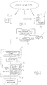
- the location system which has been represented in FIG. 1 mainly comprises a fixed station 1 placed at a point with known coordinates and a mobile 2 that an operator moves on the points that we want locate.
- Station 1 and mobile 2 are each equipped means 3 for receiving the signals transmitted by the GPS satellites of the NAVSTAR constellation.
- These means 3 are conventionally known to those skilled in the art and include a GPS reception antenna, as well only means for signal demodulation.
- the base station 1 also includes means 4 to transmit information at radio frequency for mobile 2.
- the mobile 2 is provided with receiving means 5 for receipt of information sent by means 4 from station 1.
- the reception means 3 of station 1 and the mobile 2 record the carrier phase of the signals received from each satellite observed.
- the data thus received by station 1 are transmitted to the mobile 2 by the transmission means 4.
- Base station 1 does not perform any calculations and is just retransmit the signals it receives to mobile 2.
- phase differences between, on the one hand, the signals received at base station 1 and, on the other hand, signals received at mobile 2 are processed, as well as will now be described by a unit U which the mobile 2, so as to remove phase ambiguities and thus determine the position of the mobile 2, knowing the position of base station 1 and the ephemeris of the satellites observed.
- the mobile 2 has display means 2a to which the calculated coordinates are transmitted. he also includes means for memorizing these coordinates as well as a keyboard (not shown) allowing the operator, when the antenna has been placed on a point to locate, order the storage in memory of the calculated coordinates displayed.
- step 6 the unit U checks the quality of the radio signals received.
- unit U implements initialization processing fast 8, then kinematic follow-up processing 9.
- step 10 a treatment is implemented for determining an unambiguous approximate position, in combining the use of triple phase differences at frequencies L1 and L2 and that of the pseudo-distances extracted from the measurements made on the "P" codes, well known to those skilled in the art.
- This step corrects results of the effect of ionospheric correction according to the process described above.
- step 11 the process of registration by rapid convergence corresponding to treatments described in the patent of the Applicant FR-2-715-230, which we can advantageously refer to.
- the process is first implemented, not on the frequency L1 as described in the patent above, but using linear combinations of frequencies L1 and L2 giving two apparent frequencies L4 and L5 of much larger wavelength.
- the selected linear combinations, 4L2 - 3L1 and 4L1 - 5L2 correspond to wavelengths of 1.64 m for L4 and 1.83 m for L5, which generate an amplification of 12.9 cm noise on L4, 18.5 cm on L5, with a assumption of 3 mm on L1 and 4 mm on L2.
- we use a specific linear combination which reduces to almost completely noise.
- the treatment which has just been described allows initialize the position calculated for the mobile in one very fast time (from a few seconds to tens of seconds for 99.9% reliability).
- frequencies L4 and L5 are suitable values for the GPS system, however other values may well heard be considered.
- ionospheric delays between two frequencies are linked in a given ratio, which is for example 1.65 for the delays between L2 and L1.
- step 15 or set work during kinematic determinations are by therefore preferably implemented with such composite residues, which can be used for testing consistency of position lines, even during strong ionospheric disturbances.
- the implementation of this technique allows the system to be operated at distances well over 10 km usually considered a maximum limit.
- tests are carried out validity, including a test 13 for residue control (also called consistency test) similar to that described in FR 2 715 230, as well as a test 14 on the comparative evolution of measurements and distances calculated from the position to be validated.
- the validity test takes into account no only the fractional parts of the phases but also their number of turns, which makes it much more sensitive and also allows detect lap jumps that could have occurred on either of the distances measured between the initial instant and the current instant.
- step 9 we calculates a point using only the frequencies L1 and L2.
- XL1, YL1, ZL1 and XL2, YL2, ZL2 are the coordinates determined on the phase measurements observed on L1 and L2.
Landscapes
- Engineering & Computer Science (AREA)
- Radar, Positioning & Navigation (AREA)
- Remote Sensing (AREA)
- Computer Networks & Wireless Communication (AREA)
- Physics & Mathematics (AREA)
- General Physics & Mathematics (AREA)
- Position Fixing By Use Of Radio Waves (AREA)
Applications Claiming Priority (2)
| Application Number | Priority Date | Filing Date | Title |
|---|---|---|---|
| FR9707488 | 1997-06-17 | ||
| FR9707488A FR2764708B1 (fr) | 1997-06-17 | 1997-06-17 | Perfectionnements aux procedes et systemes de localisation radiosatellitaire en temps reel, notamment de type gps |
Publications (2)
| Publication Number | Publication Date |
|---|---|
| EP0886148A1 true EP0886148A1 (de) | 1998-12-23 |
| EP0886148B1 EP0886148B1 (de) | 2005-12-28 |
Family
ID=9508058
Family Applications (1)
| Application Number | Title | Priority Date | Filing Date |
|---|---|---|---|
| EP19980401470 Expired - Lifetime EP0886148B1 (de) | 1997-06-17 | 1998-06-16 | Verfahren und System zur Echtzeit-Positionsbestimmung mittels Funksatelliten, insbesondere GPS-Satelliten |
Country Status (4)
| Country | Link |
|---|---|
| EP (1) | EP0886148B1 (de) |
| CN (1) | CN1210984A (de) |
| DE (1) | DE69832926T2 (de) |
| FR (1) | FR2764708B1 (de) |
Cited By (2)
| Publication number | Priority date | Publication date | Assignee | Title |
|---|---|---|---|---|
| FR2836997A1 (fr) * | 2002-03-08 | 2003-09-12 | Thales Sa | Procede et dispositif de determination de la position relative de deux points, a base de signaux de positionnement par satellites |
| FR2869110A1 (fr) * | 2004-04-19 | 2005-10-21 | Thales Navigation Inc | Procede et appareil de positionnement par satellites de type rtk a decorrelation et ajustement de parametres automatiques |
Families Citing this family (3)
| Publication number | Priority date | Publication date | Assignee | Title |
|---|---|---|---|---|
| RU2413959C2 (ru) * | 2006-03-06 | 2011-03-10 | Квэлкомм Инкорпорейтед | Способ определения положения путем сшивания измерений |
| US9476990B2 (en) * | 2014-12-18 | 2016-10-25 | Mitsubishi Electric Research Laboratories, Inc. | Tracking of occluded navigation satellite signals |
| CN108710140B (zh) * | 2018-04-19 | 2022-07-05 | 广州南方卫星导航仪器有限公司 | 固定基准站的位置坐标校正方法及系统、改进型rtk快速测量方法及系统 |
Citations (3)
| Publication number | Priority date | Publication date | Assignee | Title |
|---|---|---|---|---|
| WO1987006713A1 (en) * | 1986-05-01 | 1987-11-05 | Magnavox Government And Industrial Electronics Com | Method and apparatus for precision dynamic differential positioning |
| US5359332A (en) * | 1992-12-31 | 1994-10-25 | Trimble Navigation Limited | Determination of phase ambiguities in satellite ranges |
| FR2715230A1 (fr) * | 1994-01-19 | 1995-07-21 | Sercel Rech Const Elect | Procédé et système de localisation radiosatellitaire en temps réel. |
-
1997
- 1997-06-17 FR FR9707488A patent/FR2764708B1/fr not_active Expired - Lifetime
-
1998
- 1998-06-16 DE DE1998632926 patent/DE69832926T2/de not_active Expired - Lifetime
- 1998-06-16 EP EP19980401470 patent/EP0886148B1/de not_active Expired - Lifetime
- 1998-06-17 CN CN 98103299 patent/CN1210984A/zh active Pending
Patent Citations (4)
| Publication number | Priority date | Publication date | Assignee | Title |
|---|---|---|---|---|
| WO1987006713A1 (en) * | 1986-05-01 | 1987-11-05 | Magnavox Government And Industrial Electronics Com | Method and apparatus for precision dynamic differential positioning |
| US4812991A (en) * | 1986-05-01 | 1989-03-14 | Magnavox Govt. And Industrial Electronics Company | Method for precision dynamic differential positioning |
| US5359332A (en) * | 1992-12-31 | 1994-10-25 | Trimble Navigation Limited | Determination of phase ambiguities in satellite ranges |
| FR2715230A1 (fr) * | 1994-01-19 | 1995-07-21 | Sercel Rech Const Elect | Procédé et système de localisation radiosatellitaire en temps réel. |
Non-Patent Citations (1)
| Title |
|---|
| HOFFMANN-WELLENHOF ET AL: "Global Positioning System, Theory and Practice", 1994, SPRINGER-VERLAG, WIEN NEW YORK, XP002060239 * |
Cited By (4)
| Publication number | Priority date | Publication date | Assignee | Title |
|---|---|---|---|---|
| FR2836997A1 (fr) * | 2002-03-08 | 2003-09-12 | Thales Sa | Procede et dispositif de determination de la position relative de deux points, a base de signaux de positionnement par satellites |
| WO2003076962A1 (fr) * | 2002-03-08 | 2003-09-18 | Thales | Procede et dispositif de determination de la position relative de deux points |
| US7259717B2 (en) | 2002-03-08 | 2007-08-21 | Thales | Method and device for determining the relative position of two points |
| FR2869110A1 (fr) * | 2004-04-19 | 2005-10-21 | Thales Navigation Inc | Procede et appareil de positionnement par satellites de type rtk a decorrelation et ajustement de parametres automatiques |
Also Published As
| Publication number | Publication date |
|---|---|
| CN1210984A (zh) | 1999-03-17 |
| DE69832926D1 (de) | 2006-02-02 |
| FR2764708B1 (fr) | 1999-09-03 |
| FR2764708A1 (fr) | 1998-12-18 |
| DE69832926T2 (de) | 2006-08-10 |
| EP0886148B1 (de) | 2005-12-28 |
Similar Documents
| Publication | Publication Date | Title |
|---|---|---|
| FR2943868A1 (fr) | Procedes de calcul de la position d'un recepteur gnss a partir de pseudo-mesures bi et mono frequences | |
| WO2020249874A1 (fr) | Procede et systeme de localisation ponctuelle d'un vehicule a l'arret sur une voie de garage a l'aide de balises virtuelles | |
| EP2410352A1 (de) | Antennenvorrichtung mit synthetischer Öffnung zum Empfang von Signalen eines Systems, das eine Trägerwelle und Mittel zur Bestimmung ihrer Verlaufsbahn umfasst | |
| EP2921923A1 (de) | Verfahren zur Nachverfolgung einer Umlaufbahn oder einer Beförderungsphase in die Umlaufbahn eines Raumfahrzeugs, insbesondere mit elektrischem Antrieb, und Gerät für die Umsetzung dieses Verfahrens | |
| EP4451017B1 (de) | Künstliche-intelligenz-modellgestütztes verfahren zur gnss-lokalisierung | |
| WO2007082929A1 (fr) | Dispositif de controle de position(s) relative(s) par analyse de signaux bi-frequences, pour un engin spatial d'un groupe d'engins spatiaux en formation | |
| EP2500750A1 (de) | Verfahren und Vorrichtung zur Eichung eines Empfängers | |
| WO2003107031A2 (fr) | Recepteur de positionnement par satellite utilisant deux porteuses de signal | |
| CA2191550A1 (fr) | Procede et dispositif de mesure d'attitude de satellite | |
| EP2221628B1 (de) | Verfahren zur Behebung von Mehrdeutigkeit, Verfahren zur Lokalisierung eines Empfängers durch Funknavigation, das eine Etappe zur Behebung von Mehrdeutigkeit umfasst, und Lokalisierungsempfänger | |
| EP0886148B1 (de) | Verfahren und System zur Echtzeit-Positionsbestimmung mittels Funksatelliten, insbesondere GPS-Satelliten | |
| EP0014619B1 (de) | Vorrichtung zur dynamischen nicht-linearen Filterung des Winkelmessungsrauschens in einem Radarsystem und sie enthaltendes Radarsystem | |
| EP2487507B1 (de) | Erfassungsverfahren mit verbesserter frequenzieller Multikorrelation | |
| WO2002033437A1 (fr) | Systeme de suivi d"un mobile | |
| EP4165441B1 (de) | Empfänger von funknavigationssignalen mit einem rechner eines korrelationsleistungsindikators | |
| FR3150875A1 (fr) | Méthode et système de positionnement GNSS | |
| EP1373923B1 (de) | Empfänger zur bestimmung einer mobilobjektorientierung | |
| WO2024008883A1 (fr) | Procédé de détection d'un signal interférant d'un récepteur gnss et dispositif de détection associé | |
| FR2918765A1 (fr) | Procede de determination d'une erreur d'asservissement dans une boucle de poursuite d'un code pseudo-aleatoire. | |
| CA2470550A1 (fr) | Procede d'amelioration de la determination de l'attitude d'un vehicule a l'aide de signaux de radionavigation par satellite | |
| FR3066027A1 (fr) | Procede de positionnement par gnss | |
| EP1493041B1 (de) | Verfahren und einrichtung zur bestimmung der relativen position zweier punkte | |
| FR2715230A1 (fr) | Procédé et système de localisation radiosatellitaire en temps réel. | |
| FR3047567A1 (fr) | Procede de detection d'une fausse synchronisation d'un recepteur avec un satellite, recepteur et produit programmme d'ordinateur associes | |
| FR3003961A1 (fr) | Procede de formation de faisceau signaux d'un recepteur de signaux d'un systeme de navigation par satellites pour ameliorer la resistance au brouillage. |
Legal Events
| Date | Code | Title | Description |
|---|---|---|---|
| PUAI | Public reference made under article 153(3) epc to a published international application that has entered the european phase |
Free format text: ORIGINAL CODE: 0009012 |
|
| AK | Designated contracting states |
Kind code of ref document: A1 Designated state(s): BE DE GB NL |
|
| AX | Request for extension of the european patent |
Free format text: AL;LT;LV;MK;RO;SI |
|
| 17P | Request for examination filed |
Effective date: 19990621 |
|
| AKX | Designation fees paid |
Free format text: BE DE GB NL |
|
| GRAP | Despatch of communication of intention to grant a patent |
Free format text: ORIGINAL CODE: EPIDOSNIGR1 |
|
| RTI1 | Title (correction) |
Free format text: METHOD AND SYSTEM FOR REAL TIME POSITION DETERMINATION USING SATELLITES, NOTABLY OF THE GPS TYPE |
|
| RAP1 | Party data changed (applicant data changed or rights of an application transferred) |
Owner name: THALES NAVIGATION S.A. |
|
| GRAS | Grant fee paid |
Free format text: ORIGINAL CODE: EPIDOSNIGR3 |
|
| GRAA | (expected) grant |
Free format text: ORIGINAL CODE: 0009210 |
|
| AK | Designated contracting states |
Kind code of ref document: B1 Designated state(s): BE DE GB NL |
|
| REG | Reference to a national code |
Ref country code: GB Ref legal event code: FG4D Free format text: NOT ENGLISH |
|
| REF | Corresponds to: |
Ref document number: 69832926 Country of ref document: DE Date of ref document: 20060202 Kind code of ref document: P |
|
| GBT | Gb: translation of ep patent filed (gb section 77(6)(a)/1977) |
Effective date: 20060224 |
|
| PLBE | No opposition filed within time limit |
Free format text: ORIGINAL CODE: 0009261 |
|
| STAA | Information on the status of an ep patent application or granted ep patent |
Free format text: STATUS: NO OPPOSITION FILED WITHIN TIME LIMIT |
|
| 26N | No opposition filed |
Effective date: 20060929 |
|
| BECN | Be: change of holder's name |
Owner name: MAGELLAN NAVIGATION S.P.A.S. Effective date: 20051228 |
|
| BECN | Be: change of holder's name |
Owner name: MAGELLAN NAVIGATION S.P.A.S. Effective date: 20080114 |
|
| NLT1 | Nl: modifications of names registered in virtue of documents presented to the patent office pursuant to art. 16 a, paragraph 1 |
Owner name: MAGELLAN NAVIGATION SAS Owner name: MAGELLAN NAVIGATION SA |
|
| REG | Reference to a national code |
Ref country code: NL Ref legal event code: TD Effective date: 20101125 |
|
| BECH | Be: change of holder |
Owner name: MITAC INTERNATIONAL CORP Effective date: 20110106 |
|
| REG | Reference to a national code |
Ref country code: GB Ref legal event code: 732E Free format text: REGISTERED BETWEEN 20110414 AND 20110420 |
|
| REG | Reference to a national code |
Ref country code: NL Ref legal event code: SD Effective date: 20110601 |
|
| REG | Reference to a national code |
Ref country code: DE Ref legal event code: R082 Ref document number: 69832926 Country of ref document: DE Representative=s name: PRINZ & PARTNER PATENTANWAELTE RECHTSANWAELTE, DE |
|
| REG | Reference to a national code |
Ref country code: DE Ref legal event code: R082 Ref document number: 69832926 Country of ref document: DE Representative=s name: PRINZ & PARTNER MBB PATENTANWAELTE RECHTSANWAE, DE Effective date: 20110725 Ref country code: DE Ref legal event code: R082 Ref document number: 69832926 Country of ref document: DE Representative=s name: PRINZ & PARTNER PATENTANWAELTE RECHTSANWAELTE, DE Effective date: 20110725 Ref country code: DE Ref legal event code: R081 Ref document number: 69832926 Country of ref document: DE Owner name: MITAC INTERNATIONAL CORP., KUEI-SHAN HSIANG, TW Free format text: FORMER OWNER: MAGELLAN NAVIGATION S.A.S., CARQUEFOU CEDEX, FR Effective date: 20110725 Ref country code: DE Ref legal event code: R081 Ref document number: 69832926 Country of ref document: DE Owner name: MITAC INTERNATIONAL CORP., TW Free format text: FORMER OWNER: MAGELLAN NAVIGATION S.A.S., CARQUEFOU CEDEX, FR Effective date: 20110725 |
|
| REG | Reference to a national code |
Ref country code: DE Ref legal event code: R082 Ref document number: 69832926 Country of ref document: DE Representative=s name: PRINZ & PARTNER PATENTANWAELTE RECHTSANWAELTE, DE |
|
| REG | Reference to a national code |
Ref country code: DE Ref legal event code: R082 Ref document number: 69832926 Country of ref document: DE Representative=s name: PRINZ & PARTNER MBB PATENTANWAELTE RECHTSANWAE, DE Effective date: 20111017 Ref country code: DE Ref legal event code: R082 Ref document number: 69832926 Country of ref document: DE Representative=s name: PRINZ & PARTNER PATENTANWAELTE RECHTSANWAELTE, DE Effective date: 20111017 Ref country code: DE Ref legal event code: R081 Ref document number: 69832926 Country of ref document: DE Owner name: MITAC INTERNATIONAL CORP., KUEI-SHAN HSIANG, TW Free format text: FORMER OWNER: ASHTECH, CARQUEFOU, FR Effective date: 20111017 |
|
| PGFP | Annual fee paid to national office [announced via postgrant information from national office to epo] |
Ref country code: GB Payment date: 20170417 Year of fee payment: 20 Ref country code: DE Payment date: 20170418 Year of fee payment: 20 |
|
| PGFP | Annual fee paid to national office [announced via postgrant information from national office to epo] |
Ref country code: BE Payment date: 20170627 Year of fee payment: 20 Ref country code: NL Payment date: 20170627 Year of fee payment: 20 |
|
| REG | Reference to a national code |
Ref country code: DE Ref legal event code: R071 Ref document number: 69832926 Country of ref document: DE |
|
| REG | Reference to a national code |
Ref country code: NL Ref legal event code: MK Effective date: 20180615 |
|
| REG | Reference to a national code |
Ref country code: GB Ref legal event code: PE20 Expiry date: 20180615 |
|
| PG25 | Lapsed in a contracting state [announced via postgrant information from national office to epo] |
Ref country code: GB Free format text: LAPSE BECAUSE OF EXPIRATION OF PROTECTION Effective date: 20180615 |
|
| REG | Reference to a national code |
Ref country code: BE Ref legal event code: MK Effective date: 20180616 |