EP0899578A1 - Procédé de localisation d'un terminal fixe grâce à une constellation de satellites - Google Patents
Procédé de localisation d'un terminal fixe grâce à une constellation de satellites Download PDFInfo
- Publication number
- EP0899578A1 EP0899578A1 EP98402097A EP98402097A EP0899578A1 EP 0899578 A1 EP0899578 A1 EP 0899578A1 EP 98402097 A EP98402097 A EP 98402097A EP 98402097 A EP98402097 A EP 98402097A EP 0899578 A1 EP0899578 A1 EP 0899578A1
- Authority
- EP
- European Patent Office
- Prior art keywords
- terminal
- satellite
- satellites
- active
- estimated
- Prior art date
- Legal status (The legal status is an assumption and is not a legal conclusion. Google has not performed a legal analysis and makes no representation as to the accuracy of the status listed.)
- Granted
Links
- 238000000034 method Methods 0.000 title claims abstract description 39
- 230000004807 localization Effects 0.000 claims abstract description 45
- 230000005540 biological transmission Effects 0.000 claims description 3
- 230000002123 temporal effect Effects 0.000 claims description 2
- 101100006960 Caenorhabditis elegans let-2 gene Proteins 0.000 claims 1
- 238000004891 communication Methods 0.000 description 6
- 238000010586 diagram Methods 0.000 description 6
- 238000009434 installation Methods 0.000 description 4
- 230000001360 synchronised effect Effects 0.000 description 3
- 238000012550 audit Methods 0.000 description 2
- 230000000295 complement effect Effects 0.000 description 1
- 238000012937 correction Methods 0.000 description 1
- 230000001955 cumulated effect Effects 0.000 description 1
- 238000005259 measurement Methods 0.000 description 1
- 238000011160 research Methods 0.000 description 1
Images


Classifications
-
- G—PHYSICS
- G01—MEASURING; TESTING
- G01S—RADIO DIRECTION-FINDING; RADIO NAVIGATION; DETERMINING DISTANCE OR VELOCITY BY USE OF RADIO WAVES; LOCATING OR PRESENCE-DETECTING BY USE OF THE REFLECTION OR RERADIATION OF RADIO WAVES; ANALOGOUS ARRANGEMENTS USING OTHER WAVES
- G01S5/00—Position-fixing by co-ordinating two or more direction or position line determinations; Position-fixing by co-ordinating two or more distance determinations
- G01S5/02—Position-fixing by co-ordinating two or more direction or position line determinations; Position-fixing by co-ordinating two or more distance determinations using radio waves
- G01S5/12—Position-fixing by co-ordinating two or more direction or position line determinations; Position-fixing by co-ordinating two or more distance determinations using radio waves by co-ordinating position lines of different shape, e.g. hyperbolic, circular, elliptical or radial
-
- G—PHYSICS
- G01—MEASURING; TESTING
- G01S—RADIO DIRECTION-FINDING; RADIO NAVIGATION; DETERMINING DISTANCE OR VELOCITY BY USE OF RADIO WAVES; LOCATING OR PRESENCE-DETECTING BY USE OF THE REFLECTION OR RERADIATION OF RADIO WAVES; ANALOGOUS ARRANGEMENTS USING OTHER WAVES
- G01S5/00—Position-fixing by co-ordinating two or more direction or position line determinations; Position-fixing by co-ordinating two or more distance determinations
- G01S5/0009—Transmission of position information to remote stations
- G01S5/0018—Transmission from mobile station to base station
Definitions
- the field of the invention is that of telecommunications systems by satellites.
- a satellite communications system includes in particular a constellation of non-geostationary satellites (consisting for example of 64 low-orbit satellites), a plurality of base stations (or “Gateway Stations” in English), as well as a plurality of fixed terminals.
- Each base station is associated with a separate geographic unit (or “spot") and is linked to a terrestrial network of telecommunication.
- Each terminal communicates, via satellites, with the base (and therefore with the terrestrial telecommunication network) of the cell in which it is.
- Each satellite when active vis-à-vis a base station, receives from it information which it retransmits to the fixed terminal (s) present in its coverage area.
- each satellite when active vis-à-vis a base station, retransmits thereto the information it receives from each fixed terminal present in its coverage area.
- a satellite cannot be active with respect to a base station only if it is within visibility of the latter.
- the invention relates to a method for locating a terminal landline of such satellite communications system.
- each fixed terminal of the system it is indeed necessary to know the position of each fixed terminal of the system. For example, this allows you to synchronize the fixed terminals, so as to avoid or reduce interference, upon reception by the satellites, between signals transmitted by different fixed terminals. It also allows determine the tariff zone to which each fixed terminal belongs.
- the terminal considered here is fixed. Its location is therefore performed during its initial installation, or during each new installation if the terminal is moved (for example from one house to another).
- a first known solution consists in implement in this latter a receiver of one of the known localization systems, such than the GPS system (for "Global Positioning System” in English) or GLONASS (for "Global Navigation Satellite System”.
- GPS system for "Global Positioning System” in English
- GLONASS for "Global Navigation Satellite System”.
- This first known solution has the major drawback of being very expensive. Indeed, a GPS or GLONASS type receiver has too high a cost vis-à-vis the price of a fixed terminal "general public". In addition, because the location of the fixed terminal is only performed at installation, adding a receiver to the fixed terminal specialized location represents an excessive investment for its use done.
- a second known solution consists in implementing, using the existing infrastructure (that is to say in particular with the fixed terminal that one seeks to locate and some satellites of the constellation), a known localization technique, to type AOA (for "Angle Of Arrival” in English) or TDOA (for "Time Difference Of Arrival "in English).
- the position of the terminal is determined by combining angles of arrival of signals from different satellites.
- the terminal position is determined by combining differences in arrival time of signals from different satellites.
- this second known solution does not require any specialized location receiver (GPS type or GLONASS).
- the invention particularly aims to overcome these various drawbacks of the state of the art.
- one of the objectives of the present invention is to provide a method for locating a fixed terminal of a telecommunications system by satellites, this method being simple to implement and inexpensive.
- the invention also aims to provide such a method not requiring the implementation in the fixed terminal of a specialized location receiver (of the type GPS or GLONASS).
- Another object of the invention is to provide such a method using existing system infrastructure without imposing harsh conditions on the terminal fixed (no precise azimuth reference) or to satellites (the latter need not be synchronous).
- the localization method according to the present invention therefore comprises a phase of "average” location, for example ⁇ 300 m.
- the general principle of this phase of "average” location consists, for the terminal, of calculating the intersection of at least three hyperboloids on which it is located, assuming already known an estimate of its "coarse” position (for example ⁇ 100 km).
- each hyperboloid of the invention does not correspond to a real image of the system since it is not calculated according to the position, at a given single instant, of the first and second satellites.
- each hyperboloid of the invention corresponds to an image fictitious system, taking into account on the one hand the position pl, at a given first instant t1, of the first satellite and on the other hand of the position p2, at a second given time t2, of the second satellite.
- the only condition imposed by the invention is that the instants t1 'and t2' of reception by the terminal are equal or close to each other (for example offset from a few milliseconds), so that the estimate of (t2 '- t1') is correct despite the fact that the terminal clock is not very precise compared to that of each of the satellites.
- the number of satellites required differs according to the number of satellites that the terminal is able to listen to simultaneously. For example, if the terminal is able to listen to three satellites simultaneously, it can receive, at times t1 ', t2' and t3 'close or equal, information from these three satellites, and calculate the following three hyperboloids: H 1,2 , H 1,3 and H 2,3 , where the hyperboloid H i, j is calculated using the i-th and j-th satellites. On the other hand, if the terminal is only able to listen to two satellites simultaneously, then the calculation of the following three hyperboloids: H 1.2 , H 3.4 and H 5.6 requires six separate satellites.
- the base station transmits said first and second information with a temporal precompensation such as after retransmission by said first and second satellites, said first and second information are received substantially simultaneously by said base station.
- the terminal can approximately point (but sufficiently) on any satellite entering the spot. By following this satellite, the terminal is kept informed of any inter-satellite jump. So during the jump inter-satellite, which usually lasts a few seconds, the terminal has two satellites (one incoming and one outgoing) active simultaneously.
- each terminal comprises reception means simultaneous information from at least two separate satellites.
- said means for simultaneously receiving information transmitted by at least two separate satellites include at least two directional antennas each pointed at a separate satellite.
- the location method according to the present invention therefore also comprises a "coarse” location phase, for example ⁇ 100 km.
- the general principle of this "rough" location phase consists, for the terminal, of calculating the intersection at least three isoelevation surfaces on which it is located.
- step -b- assumes that the ephemeris of each of the satellites of the constellation is known to the system. Furthermore, step -c- assumes that the terminal knows the angle of elevation a of its antenna relative to the ground. This can be considered in placing the terminal horizontally.
- At least one has an azimuth ⁇ , seen by said terminal, at least 10 ° from the azimuths of the other two satellites.
- said two directional antennas rotate at the same elevation, each covering approximately 180 ° around the angle azimuth ⁇ .
- each antenna covers, in a complementary way with the other antenna, a half-turn, and we therefore minimize the time necessary to scan on a turn complete (that is to say for the azimuth 0 varying from 0 to 2 ⁇ ).
- the localization method according to the present invention therefore comprises a phase "fine” location, for example ⁇ 60 m.
- the general principle of this phase of "fine” localization consists in calculating the time advance (or “Timing Advance” in English) that the terminal presents with respect to the time station, or more precisely the time advance presented by the signals from the terminal (via the active satellite) when received by the base station.
- this "fine” localization phase is active and not passive.
- the terminal enters here in communication, via an active satellite, with the cell's base station where it is located. This entry into communication is done for example at particular times, reserved during light traffic and allowing to receive offset signals.
- steps -1- to -5- are repeated several times using the same previous "fine” estimated position
- a step should be planned additional determination of the new optimal "fine” estimated position among a predetermined set of possible positions.
- This predetermined set includes by example all the points included in a disc centered on the estimated “fine” position previous and of radius equal to the uncertainty on the estimation of this estimated position "fine” former.
- step -7- each new iteration of steps -1- to -5- or -0- to -6- is performed with the same satellite, but at azimuths ⁇ and / or elevations ⁇ , seen by said terminal, at least 10 ° apart.
- step -7- each new iteration of the steps -1- to -5- or -0- to -6- is performed with a separate satellite.
- the invention therefore relates to a method for locating a fixed terminal of a satellite communications system.
- such a satellite communications system includes a constellation of satellites, a plurality of base stations and a plurality of fixed terminals.
- each terminal includes two antennas guidelines for the simultaneous reception of information from two satellites separate. It is clear, however, that each terminal can include listening means more than two satellites simultaneously.
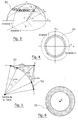
- the terminal searches for a satellite in a ring where the satellite can potentially be located, knowing that the satellite is at a predetermined distance from the earth (for example 1500 km).
- Figures 3 and 4 each have a view, in perspective and from above respectively, of such a ring 30 search by the terminal T of a satellite S at a given elevation.
- the two directional antennas of the terminal rotate at the same elevation, each covering approximately 180 ° around the angle azimuth ⁇ .
- Figures 5 and 6 each show a side and top view (of satellite S) respectively, of an isoelevation surface calculated by the terminal T during the step referenced 22.
- the isoelevation surface is a crown 50.
- the terminal At the end of this "rough" location phase 1, the terminal has a estimated "coarse” position 24, for example at 200 km (that is to say ⁇ 100 km).
- the terminal can correct the azimuth bias, for example around ⁇ 2 °, thanks to the "rough" location of the terminal and of the N satellites acquired successively, as well as a time correction to a few milliseconds, which allows to keep a time reference of less than 1 second during all the phases following "medium” and "fine” locations.
- the terminal can repeat M times the N iterations of the aforementioned steps 70 to 72 as well as the aforementioned step 73, so as to obtain M times a new estimated position "average" 74 '.
- point P we search for point P, among a predetermined set of points, which minimizes the error of the estimated position "average” of the terminal, when this error is cumulated on the M estimated positions "averages" all calculated from the same estimated position "coarse” or previous "average".
- the predetermined set of points is for example a disc whose center is the estimated “rough” position (for the first calculation of a position "average” estimated) or the previous "average” estimated position (for each calculation of a new estimated position "average"), and the radius is the uncertainty presented by the estimated position ("rough" or "average” previous) to which the center of the disk.
- the terminal can calculate ⁇ t 'and ⁇ t since it receives ti and tj. Furthermore, it measures ti 'and tj' itself. Consequently, knowing the positions pi and pj of the ith and jth satellites at times ti and tj respectively, the terminal can calculate the hyperboloid H i, j .
- a hyperboloid H i, j For the calculation of a hyperboloid H i, j , one uses either two active satellites simultaneously active at any time, or two active satellites (outgoing and entering respectively) simultaneously active only during an inter-satellite jump ("hand- off ").
- Each of the terminal's two directional antennas is pointed at a satellite separate. As already stated above, it is clear that if the terminal can listen simultaneously more than two active satellites, then several hyperboloids can be calculated from the different information received. Each pair of satellites allows calculate a hyperboloid.
- FIG. 8 makes it possible to view the instants t1, t2, t1 'and t2', with the respective elements concerned (namely the first satellite for t1, the second satellite for t2, and the terminal for t1 'and t2'), thus than the time intervals ⁇ t and ⁇ t '.
- This FIG. 8 also illustrates the fact that the base station transmits, at instants t s 1 and t s 2 , the first and second information that the first and second satellites retransmit at instants t1 and t2.
- the base station transmits (at times t s 1 and t s 2 ) with time precompensation, so that the first and second information retransmitted (at times t s 1 and t s 2 ) by the first and second satellites are received substantially simultaneously (at time t GW 0 ) by the base station.
- the terminal At the end of this "average” location phase 1, the terminal has a estimated position "average” 74 or 74 ', for example ⁇ 350 m).
- the step 94 for determining of the estimated "fine” position 95 we search for point P, among a set predetermined points, which minimizes the error presented by the estimated “fine” position of the terminal, when this error is accumulated on the M estimated “fine” positions all calculated from the same estimated position "average” or “fine” previous.
- the predetermined set of points is for example a disc whose center is the position estimated “average” (for the first calculation of an estimated position “fine”) or the position estimated “fine” previous (for each calculation of a new position estimated “fine”), and the radius is the uncertainty presented by the estimated position ("average” or “fine” previous) which is equal to the center of the disc.
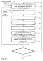
- the second embodiment of the "fine" localization phase 3, presented on the flowchart of Figure 11, differs from the first embodiment in that it is the base station, and not the terminal, which calculates the estimated “fine” position of the terminal.
Landscapes
- Physics & Mathematics (AREA)
- Engineering & Computer Science (AREA)
- General Physics & Mathematics (AREA)
- Radar, Positioning & Navigation (AREA)
- Remote Sensing (AREA)
- Position Fixing By Use Of Radio Waves (AREA)
- Radio Relay Systems (AREA)
- Mobile Radio Communication Systems (AREA)
Abstract
Description
un ou plusieurs satellite(s) étant dit(s) actif(s) vis-à-vis d'une station de base donnée lorsqu'il(s) se trouve(nt) en visibilité de celle-ci, chaque satellite actif qui reçoit des informations de la station de base vis-à-vis de laquelle il est actif les retransmettant vers le ou les terminaux fixes présents dans sa zone de couverture, chaque satellite actif qui reçoit des informations d'un terminal fixe présent dans sa zone de couverture les retransmettant vers la station de base vis-à-vis de laquelle il est actif,
le procédé comprenant une phase de localisation "moyenne", comprenant elle-même les étapes suivantes :
- d1 est la distance entre le terminal et ladite position pl du premier satellite actif à l'instant t1,
- d2 est la distance entre le terminal et ladite position p2 du second satellite actif à l'instant t2,
- t1 et t2 sont lesdits premier et second instants de retransmission par lesdits premier et second satellites respectivement,
- t1' et t2' sont lesdits premier et second instants de réception par le terminal,
- c est la vitesse de la lumière ;
- un couple de deux satellites distincts desdits premier et second satellites ;
- un couple de deux satellites dont l'un est un desdits premier et second satellites et l'autre est distinct desdits premier et second satellites.
- les couples dont les deux satellites sont simultanément actifs à un instant quelconque ;
- les couples dont les deux satellites, dits satellites sortant et entrant respectivement, sont simultanément actifs uniquement lors d'un saut inter-satellites (ou "hand-off' en anglais) du type permettant à une station de base de remplacer ledit satellite actif sortant, qui cesse d'être en visibilité, par ledit satellite actif entrant, qui arrive en visibilité.
- -5'- à partir de ladite information relative à l'avance temporelle et de ladite position estimée "moyenne", ladite station de base calcule la position estimée "fine" du terminal.
- la figure 1 présente un organigramme simplifié d'un mode de réalisation particulier du procédé de localisation selon l'invention ;
- la figure 2 présente un organigramme simplifié d'un mode de réalisation particulier de la phase de localisation "grossière" apparaissant sur l'organigramme de la figure 1 ;
- les figures 3 et 4 présentent chacune une vue, en perspective et de dessus respectivement, d'un anneau de recherche d'un satellite à une élévation donnée, permettant d'expliciter l'une des étapes de l'organigramme de la figure 2 ;
- les figures 5 et 6 présentent chacune une vue, de côté et du satellite respectivement, d'une surface isoélévation, permettant d'expliciter l'une des étapes de l'organigramme de la figure 2 ;
- la figure 7 présente un organigramme simplifié d'un mode de réalisation particulier de la phase de localisation "moyenne" apparaissant sur l'organigramme de la figure 1 ;
- la figure 8 présente un schéma illustrant de façon temporelle certaines étapes de l'organigramme de la figure 7 ;
- la figure 9 présente un organigramme simplifié d'un premier mode de réalisation particulier de la phase de localisation "fine" apparaissant sur l'organigramme de la figure 1;
- la figure 10 présente un schéma illustrant de façon temporelle certaines étapes de l'organigramme de la figure 9 ; et
- la figure 11 présente un organigramme simplifié d'un second mode de réalisation particulier de la phase de localisation "fine" apparaissant sur l'organigramme de la figure 1.
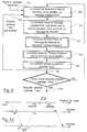
- une phase de localisation "grossière" 1, par exemple à ± 100 km ;
- une phase de localisation "moyenne" 2, par exemple à ± 350 m ; et
- une phase de localisation "fine" 3, par exemple à ± 60 m.
- le terminal recherche et acquiert (20) un satellite, pour une élévation α prédéterminée, en faisant varier son azimuth ;
- le terminal reçoit (21) du satellite acquis une information relative à la position de ce satellite acquis ;
- le terminal calcule (22), à partir de l'information relative à la position du satellite acquis, une surface isoélévation, projetée sur un modèle de terre prédéterminé et sur laquelle se trouve le terminal ;
- le terminal réitère les étapes précitées 20 à 22, de façon à effectuer N itérations au total, avec N ≥ 3. Le terminal calcule donc N surfaces isoélévation sur lesquelles il se trouve. Les N satellites, acquis lors des N itérations des étapes précitées 20 à 22, possèdent des azimuths , vus par le terminal, distants par exemple d'au moins 30°. D'une façon générale, sur les N satellites, acquis lors des itérations successives, au moins un possède un azimuth , vus par le terminal, distant d'au moins 10° des azimuth des deux autres satellites ;
- le terminal détermine (23) une position estimée "grossière", en calculant l'intersection des N surfaces isoélévation.
- à un premier instant t1', le terminal reçoit (70) d'un premier satellite actif ("satellite 1") de premières informations relatives d'une part à l'instant t1 de retransmission des premières informations par le premier satellite actif et d'autre part à la position p1 du premier satellite actif à l'instant t1 ;
- à un second instant t2', égal à ou proche du premier instant t1', le terminal reçoit (71) d'un second satellite actif ("satellite 2") de secondes informations relatives d'une part à l'instant t2 de retransmission des secondes informations par le second satellite actif et d'autre part à la position p2 du second satellite actif à l'instant t2 ;
- le terminal calcule (72) un premier hyperboloïde H1,2 sur lequel se trouve le terminal (cf explication détaillée ci-dessous) ;
- le terminal réitère les étapes précitées 70 à 72, de façon à effectuer N itérations au total, avec N ≥ 3. Le terminal calcule donc N hyperboloïdes sur lesquels il se trouve ;
- connaissant la position estimée "grossière" 24, le terminal détermine (73) une position estimée "moyenne" 74, en calculant l'intersection des N hyperboloïdes.
- di est la distance entre le terminal et la position pi du ième satellite actif à l'instant ti,
- dj est la distance entre le terminal et la position pj du jème satellite actif à l'instant tj,
- ti et tj sont les ième et jème instants de retransmission par les ième et jème satellites respectivement,
- ti' et tj' sont les ième et jème instants de réception par le terminal,
- c est la vitesse de la lumière.
- la station de base (associée à la cellule dans laquelle se trouve le terminal) émet (90) vers le terminal, via un satellite actif, un message prédéterminé. Comme présenté sur la figure 10, la station de base émet à l'instant tGW 0 et le satellite retransmet à l'instant ts 0 ;
- le terminal reçoit, à l'instant tT 0, le message prédéterminé et, connaissant d'une part sa position estimée "moyenne" et d'autre part la position temps réel du satellite actif, génère puis émet (91) vers la station de base, via le satellite actif, un message de réponse indiquant notamment l'intervalle de temps ΔtT entre l'instant tT 0 de réception du message prédéterminé et l'instant d'émission tT du message de réponse. Comme présenté sur la figure 10, le satellite retransmet à l'instant ts le message de réponse émis par le terminal à l'instant tT;
- la station de base reçoit, à l'instant "tGW mesuré", le message de réponse et, à partir de ce dernier, calcule (92) une information relative à l'avance temporelle ΔtTA que présente le message de réponse provenant du terminal. En fait, la station de base calcule la différence ΔtTA entre l'instant de réception "tGW mesuré" et l'instant de réception "tGW attendu". On a : ΔtTA = 0 (c'est-à-dire une avance temporelle nulle), seulement si la position estimée utilisée est parfaitement égale à la position réelle du terminal ;
- la station de base émet (93) vers le terminal, via le satellite actif, l'information relative à l'avance temporelle ΔtTA ;
- à partir de l'information relative à l'avance temporelle ΔtTA et de la position . estimée "moyenne", le terminal calcule (94) sa position estimée "fine" 95 ;
- en utilisant la position estimée "fine" (précédente) 95 à la place de la position estimée "moyenne" 74 ou 74', le terminal réitère M fois les étapes précitées 90 à 94, de façon à obtenir M fois une nouvelle position estimée "fine" 95'. Chacune de ces M itération est par exemple effectuée avec un satellite distinct. On notera que si c'est avec un même satellite, alors il est préférable que pour deux itérations successives, le satellite possède des azimuths et/ou des élévations α, vus par le terminal, distants d'au moins 10°.
- le terminal émet (110) vers la station de base, via le satellite actif, une information relative à sa position estimée "fine";
- la station de base émet (112) vers le terminal, via le satellite actif, la position estimée "moyenne" du terminal.
- à partir de l'information relative à l'avance temporelle et de la position estimée "moyenne", la station de base calcule (111) la position estimée "fine" du terminal.
Claims (15)
- Procédé de localisation d'un terminal fixe d'un système de télécommunications par satellites du type comprenant une constellation de satellites, une pluralité de stations de base, chacune associée à une cellule géographique distincte et reliée à un réseau terrestre de télécommunication, et une pluralité de terminaux fixes,
un ou plusieurs satellite(s) ne pouvant être étant dit(s) actif(s) vis-à-vis d'une station de base donnée que s'il(s) se trouve(nt) en visibilité de celle-ci, chaque satellite actif qui reçoit des informations de la station de base vis-à-vis de laquelle il est actif les retransmettant vers le ou les terminaux fixes présents dans sa zone de couverture, chaque satellite actif qui reçoit des informations d'un terminal fixe présent dans sa zone de couverture les retransmettant vers la station de base vis-à-vis de laquelle il est actif,
caractérisé en ce qu'il comprend une phase de localisation "moyenne" (2), comprenant elle-même les étapes suivantes :-i- à un premier instant t1', ledit terminal reçoit (70) d'un premier satellite actif de premières informations relatives d'une part à l'instant t1 de retransmission desdites premières informations par ledit premier satellite actif et d'autre part à la position p1 dudit premier satellite actif audit instant t1 ;-ii- à un second instant t2', égal à ou proche dudit premier instant t1', ledit terminal reçoit (71) d'un second satellite actif de secondes informations relatives d'une part à l'instant t2 de retransmission desdites secondes informations par ledit second satellite actif et d'autre part à la position p2 dudit second satellite actif audit instant t2 ;-iii- ledit terminal calcule (72) un premier hyperboloïde H1,2 sur lequel se trouve ledit terminal et tel que : H1,2 = d2 - d1 = (t2' - t2).c - (t1' - t1).c, où :d1 est la distance entre le terminal et ladite position pl du premier satellite actif à l'instant t1,d2 est la distance entre le terminal et ladite position p2 du second satellite actif à l'instant t2,t1 et t2 sont lesdits premier et second instants de retransmission par lesdits premier et second satellites respectivement,t1' et t2' sont lesdits premier et second instants de réception par le terminal,c est la vitesse de la lumière ;-iv- ledit terminal réitère les étapes -i- à -iii- (70 à 72) au moins deux fois, de façon à calculer au moins des second et troisième hyperboloïdes sur lesquels se trouve ledit terminal ;-v- ledit terminal détermine (73) une position estimée "moyenne", en calculant l'intersection desdits premier et au moins second et troisième hyperboloïdes et en supposant connue une position estimée "grossière" dudit terminal. - Procédé selon la revendication 1, caractérisé en ce que, dans ladite étape -iv-, chaque nouvelle itération des étapes -i- à -iii- (70 à 72) est effectuée avec un couple de satellites appartenant au groupe comprenant :un couple de deux satellites distincts desdits premier et second satellites ;un couple de deux satellites dont l'un est un desdits premier et second satellites et l'autre est distinct desdits premier et second satellites.
- Procédé selon l'une quelconque des revendications let 2, caractérisé en ce que ladite phase de localisation "moyenne" (2) comprend en outre l'étape suivante :-vi- en utilisant la position estimée "moyenne" précédente (74) à la place de ladite position estimée "grossière", ledit terminal réitère au moins une fois les étapes -i- à -v-, de façon à obtenir une nouvelle position estimée "moyenne" (74').
- Procédé selon l'une quelconque des revendications 1 à 3, caractérisé en ce que la station de base, vis-à-vis de laquelle lesdits premier et second satellites sont actifs, émet lesdites premières et secondes informations avec une précompensation temporelle telle qu'après retransmission par lesdits premier et second satellites, lesdites premières et secondes informations sont reçues sensiblement simultanément par ladite station de base.
- Procédé selon l'une quelconque des revendications 1 à 4, caractérisé en ce que le couple desdits premier et second satellites actifs appartient au groupe comprenant :les couples dont les deux satellites sont simultanément actifs à un instant quelconque ;les couples dont les deux satellites, dits satellites sortant et entrant respectivement, sont simultanément actifs uniquement lors d'un saut inter-satellites ("hand-off") du type permettant à une station de base de remplacer ledit satellite actif sortant, qui cesse d'être en visibilité, par ledit satellite actif entrant, qui arrive en visibilité.
- Procédé selon l'une quelconque des revendications 1 à 5, caractérisé en ce que chaque terminal comprend des moyens de réception simultanée d'informations émises par au moins deux satellites distincts.
- Procédé selon la revendication 6, caractérisé en ce que lesdits moyens de réception simultanée d'informations émises par au moins deux satellites distincts comprennent au moins deux antennes directives pointées chacune sur un satellite distinct.
- Procédé selon l'une quelconque des revendications 1 à 7, caractérisé en ce que ladite phase de localisation "moyenne" (2) est précédée d'une phase de localisation "grossière" (1) comprenant les étapes suivantes :-a- ledit terminal recherche et acquiert (20) un satellite, pour une élévation a prédéterminée, en faisant varier son azimuth ;-b- ledit terminal reçoit (21) dudit satellite acquis une information relative à la position dudit satellite acquis ;-c- ledit terminal calcule (22), à partir de ladite information relative à la position du satellite acquis, une surface isoélévation, projetée sur un modèle de terre prédéterminé et sur laquelle se trouve ledit terminal ;-d- ledit terminal réitère les étapes -a- à -c- (20 à 22) au moins deux fois, de façon à calculer au moins deux autres surfaces isoélévation sur lesquelles se trouve ledit terminal ;-e- ledit terminal détermine (23) une position estimée "grossière", en calculant l'intersection desdites au moins trois surfaces isoélévation.
- Procédé selon la revendication 8, caractérisé en ce que, sur lesdits au moins trois satellites, acquis lors des itérations successives des étapes -a- à -c- (20 à 22), au moins un possède un azimuth , vus par ledit terminal, distant d'au moins 10° des azimuth des deux autres satellites.
- Procédé selon la revendication 7 et l'une quelconque des revendications 8 et 9, caractérisé en ce que, lors de ladite étape -a- (20), lesdites deux antennes directives tournent à une même élévation, chacune couvrant environ 180° autour de l'angle d'azimuth .
- Procédé selon l'une quelconque des revendications 1 à 10, caractérisé en ce que ladite phase de localisation "moyenne" (2) est suivie d'une phase de localisation "fine" (3) comprenant les étapes suivantes :-1- la station de base associée à la cellule dans laquelle se trouve ledit terminal émet (90) vers ledit terminal, via un satellite actif vis-à-vis de ladite station de base, un message prédéterminé ;-2- ledit terminal reçoit (91) ledit message prédéterminé et, connaissant d'une part sa position estimée "moyenne" et d'autre part la position temps réel des satellites de ladite constellation, génère puis émet vers ladite station de base, via ledit satellite actif, un message de réponse indiquant notamment l'intervalle de temps entre la réception dudit message prédéterminé et l'émission dudit message de réponse ;-3- à partir dudit message de réponse, ladite station de base calcule (92) une information relative à l'avance temporelle que présente ledit terminal ;-4- ladite station de base émet (93) vers ledit terminal, via ledit satellite actif, ladite information relative à l'avance temporelle ;-5- à partir de ladite information relative à l'avance temporelle et de ladite position estimée "moyenne", ledit terminal calcule (94) sa position estimée "fine".
- Procédé selon la revendication 11, caractérisé en ce que ladite phase de localisation "fine" (3) comprend en outre les étapes préalable et finale suivantes :en ce que ladite étape -5- (94) est remplacée par l'étape suivante :-0- ledit terminal émet (110) vers ladite station de base, via ledit satellite actif, une information relative à sa position estimée "moyenne" ;-6- ladite station de base émet (112) vers ledit terminal, via ledit satellite actif, ladite position estimée "fine" du terminal ;-5'- à partir de ladite information relative à l'avance temporelle et de ladite position estimée "moyenne", ladite station de base calcule (111) la position estimée "fine" du terminal.
- Procédé selon l'une quelconque des revendications 11 et 12, caractérisé en ce que ladite phase de localisation "fine" (3) comprend en outre l'étape suivante :-7- en utilisant la position estimée "fine" précédente à la place de ladite position estimée "moyenne", ledit terminal réitère au moins une fois les étapes -1- à -5- (90 à 92) ou -0- à -6- (110, 90 à 93, 111 et 112), de façon à obtenir une nouvelle position estimée "fine".
- Procédé selon la revendication 13, caractérisé en ce que, dans l'étape -7-, chaque nouvelle itération des étapes -1- à -5- ou -0- à -6- est effectuée avec un même satellite, mais à des azimuths et/ou des élévations a, vus par ledit terminal, distants d'au moins 10°.
- Procédé selon la revendication 13, caractérisé en ce que, dans l'étape -7-, chaque nouvelle itération des étapes -1- à -5- ou -0- à -6- est effectuée avec un satellite distinct.
Applications Claiming Priority (2)
| Application Number | Priority Date | Filing Date | Title |
|---|---|---|---|
| FR9710602 | 1997-08-25 | ||
| FR9710602A FR2767616B1 (fr) | 1997-08-25 | 1997-08-25 | Procede de localisation d'un terminal fixe grace a une constellation de satellites |
Publications (2)
| Publication Number | Publication Date |
|---|---|
| EP0899578A1 true EP0899578A1 (fr) | 1999-03-03 |
| EP0899578B1 EP0899578B1 (fr) | 2001-10-04 |
Family
ID=9510459
Family Applications (1)
| Application Number | Title | Priority Date | Filing Date |
|---|---|---|---|
| EP98402097A Expired - Lifetime EP0899578B1 (fr) | 1997-08-25 | 1998-08-24 | Procédé de localisation d'un terminal fixe grâce à une constellation de satellites |
Country Status (9)
| Country | Link |
|---|---|
| US (1) | US6195042B1 (fr) |
| EP (1) | EP0899578B1 (fr) |
| JP (1) | JPH11133132A (fr) |
| CN (1) | CN1212375A (fr) |
| CA (1) | CA2243620A1 (fr) |
| DE (1) | DE69801879T2 (fr) |
| ES (1) | ES2162403T3 (fr) |
| FR (1) | FR2767616B1 (fr) |
| ID (1) | ID20743A (fr) |
Families Citing this family (8)
| Publication number | Priority date | Publication date | Assignee | Title |
|---|---|---|---|---|
| JP4726306B2 (ja) * | 2001-01-31 | 2011-07-20 | パナソニック株式会社 | 無線通信システム、移動端末局及び方位決定方法 |
| CN100336326C (zh) * | 2002-10-11 | 2007-09-05 | 中兴通讯股份有限公司 | 一种对软切换状态下用户设备进行定位的方法 |
| US7203500B2 (en) * | 2003-08-01 | 2007-04-10 | Intel Corporation | Apparatus and associated methods for precision ranging measurements in a wireless communication environment |
| US20060238419A1 (en) * | 2005-04-25 | 2006-10-26 | Bucknor Brian E | Method and apparatus for aiding positioning of a satellite positioning system and receiver |
| CN104267420B (zh) * | 2014-09-15 | 2017-04-05 | 中国电子科技集团公司第三十六研究所 | 一种星载对运动目标的三维定位方法、装置和系统 |
| MX2020011917A (es) * | 2018-05-07 | 2021-04-13 | Atc Tech Llc | Dispositivos, métodos y sistemas para sincronización de enlace ascendente en red de satélite de acceso múltiple por división de tiempo (tdma). |
| EP4254990A1 (fr) * | 2020-11-30 | 2023-10-04 | Beijing Xiaomi Mobile Software Co., Ltd. | Procédé et appareil de détermination d'emplacement, et dispositif de communication |
| CN115480212B (zh) * | 2022-09-15 | 2026-03-20 | 紫金山实验室 | 定位方法、装置、基站、存储介质和计算机程序产品 |
Citations (2)
| Publication number | Priority date | Publication date | Assignee | Title |
|---|---|---|---|---|
| DE1591518B1 (de) * | 1967-07-21 | 1970-04-23 | Siemens Ag | Funk-Ortungsverfahren mit Hilfe von Satelliten |
| WO1992021181A1 (fr) * | 1991-05-20 | 1992-11-26 | Qualcomm Incorporated | Systeme et procede de navigation a deux satellites |
-
1997
- 1997-08-25 FR FR9710602A patent/FR2767616B1/fr not_active Expired - Fee Related
-
1998
- 1998-08-24 US US09/138,658 patent/US6195042B1/en not_active Expired - Fee Related
- 1998-08-24 CN CN98119868.6A patent/CN1212375A/zh active Pending
- 1998-08-24 ID IDP981155A patent/ID20743A/id unknown
- 1998-08-24 JP JP10236964A patent/JPH11133132A/ja active Pending
- 1998-08-24 EP EP98402097A patent/EP0899578B1/fr not_active Expired - Lifetime
- 1998-08-24 ES ES98402097T patent/ES2162403T3/es not_active Expired - Lifetime
- 1998-08-24 CA CA002243620A patent/CA2243620A1/fr not_active Abandoned
- 1998-08-24 DE DE69801879T patent/DE69801879T2/de not_active Expired - Fee Related
Patent Citations (2)
| Publication number | Priority date | Publication date | Assignee | Title |
|---|---|---|---|---|
| DE1591518B1 (de) * | 1967-07-21 | 1970-04-23 | Siemens Ag | Funk-Ortungsverfahren mit Hilfe von Satelliten |
| WO1992021181A1 (fr) * | 1991-05-20 | 1992-11-26 | Qualcomm Incorporated | Systeme et procede de navigation a deux satellites |
Also Published As
| Publication number | Publication date |
|---|---|
| US6195042B1 (en) | 2001-02-27 |
| JPH11133132A (ja) | 1999-05-21 |
| DE69801879D1 (de) | 2001-11-08 |
| FR2767616B1 (fr) | 1999-09-24 |
| DE69801879T2 (de) | 2002-04-25 |
| CN1212375A (zh) | 1999-03-31 |
| EP0899578B1 (fr) | 2001-10-04 |
| ES2162403T3 (es) | 2001-12-16 |
| ID20743A (id) | 1999-02-25 |
| CA2243620A1 (fr) | 1999-02-25 |
| FR2767616A1 (fr) | 1999-02-26 |
Similar Documents
| Publication | Publication Date | Title |
|---|---|---|
| JP5026634B2 (ja) | 無線通信信号による衛星位置決めの強化 | |
| EP1804071B1 (fr) | Procédé d'optimisation des traitements de données de localisation en présence de plusieurs constellations de positionnement par satellites | |
| US20020149515A1 (en) | Method for positioning, a positioning system, and an electronic device | |
| JP2004301838A (ja) | 移動端末の位置を割り出す方法及びシステム | |
| FR2740225A1 (fr) | Appareil et procede de radiolocalisation par satellite et charge utile de satellite ainsi que station terrestre pour la mise en oeuvre de ce procede | |
| FR2795525A1 (fr) | Procede et appareil permettant de determiner une position geographique d'une unite mobile | |
| FR2782868A1 (fr) | Systeme et procede de determination de position utilisant un satellite en orbite terrestre geosynchrone | |
| CA2787939A1 (fr) | Procede de detection de messages sia | |
| EP3698173B1 (fr) | Système de positionnement avec moyens de génération de signaux gnss et câble rayonnant | |
| FR2782226A1 (fr) | Procede de localisation d'un telephone mobile | |
| EP0899578B1 (fr) | Procédé de localisation d'un terminal fixe grâce à une constellation de satellites | |
| EP1577644A1 (fr) | Procédé de guidage en temps réel d'un véhicule terrestre muni d'un système de navigation débarqué | |
| EP1544636B1 (fr) | Dispositif de determination par filtrage de données d'integrité d'un système d'augmentation, pour un terminal mobile | |
| EP1697757B1 (fr) | Procede de mise a jour du biais d'horloge existante entre une station bts d'un reseau gsm et les satellites d'un systeme gps | |
| WO2001081943A1 (fr) | Procede et dispositif de determination instantanee d'orientation, a base de signaux de positionnement par satellites | |
| EP1804399B1 (fr) | Procédé de synchronisation de stations de base d'un réseau de communication céllulaire terrestre | |
| EP1804070B1 (fr) | Procédé d'acquisition accelérée de signaux satellitaires | |
| EP1801608A1 (fr) | Procédé et système de pré-localisation pour l'assistance aux systèmes de radio-navigation par satellites | |
| EP1739881A1 (fr) | Détermination de la position d'une station de base puis d'un terminal dans un réseau LAN sans fil | |
| EP1751576A1 (fr) | Procede, systeme et module de localisation d"un terminal de telecommunication | |
| EP0702865B1 (fr) | Selection d'un satellite de rattachement | |
| EP4158383A1 (fr) | Méthode de positionnement gnss déportée dans le cloud | |
| EP1139690B1 (fr) | Procédé de localisation d'un téléphone mobile | |
| EP1146444A1 (fr) | Procédé et système de fourniture d'un service géo-dépendant, équipement de localisation et équipement d'exploitation correspondants | |
| EP1946141B1 (fr) | Procede de determination de la position de satellites dans un systeme de navigation |
Legal Events
| Date | Code | Title | Description |
|---|---|---|---|
| PUAI | Public reference made under article 153(3) epc to a published international application that has entered the european phase |
Free format text: ORIGINAL CODE: 0009012 |
|
| AK | Designated contracting states |
Kind code of ref document: A1 Designated state(s): DE ES FI GB IT |
|
| AX | Request for extension of the european patent |
Free format text: AL;LT;LV;MK;RO;SI |
|
| RAP3 | Party data changed (applicant data changed or rights of an application transferred) |
Owner name: ALCATEL |
|
| 17P | Request for examination filed |
Effective date: 19990903 |
|
| AKX | Designation fees paid |
Free format text: DE ES FI GB IT |
|
| 17Q | First examination report despatched |
Effective date: 20000322 |
|
| GRAG | Despatch of communication of intention to grant |
Free format text: ORIGINAL CODE: EPIDOS AGRA |
|
| GRAG | Despatch of communication of intention to grant |
Free format text: ORIGINAL CODE: EPIDOS AGRA |
|
| GRAH | Despatch of communication of intention to grant a patent |
Free format text: ORIGINAL CODE: EPIDOS IGRA |
|
| GRAH | Despatch of communication of intention to grant a patent |
Free format text: ORIGINAL CODE: EPIDOS IGRA |
|
| GRAA | (expected) grant |
Free format text: ORIGINAL CODE: 0009210 |
|
| AK | Designated contracting states |
Kind code of ref document: B1 Designated state(s): DE ES FI GB IT |
|
| PG25 | Lapsed in a contracting state [announced via postgrant information from national office to epo] |
Ref country code: FI Free format text: LAPSE BECAUSE OF FAILURE TO SUBMIT A TRANSLATION OF THE DESCRIPTION OR TO PAY THE FEE WITHIN THE PRESCRIBED TIME-LIMIT Effective date: 20011004 |
|
| GBT | Gb: translation of ep patent filed (gb section 77(6)(a)/1977) |
Effective date: 20011004 |
|
| REF | Corresponds to: |
Ref document number: 69801879 Country of ref document: DE Date of ref document: 20011108 |
|
| REG | Reference to a national code |
Ref country code: ES Ref legal event code: FG2A Ref document number: 2162403 Country of ref document: ES Kind code of ref document: T3 |
|
| REG | Reference to a national code |
Ref country code: GB Ref legal event code: IF02 |
|
| PLBE | No opposition filed within time limit |
Free format text: ORIGINAL CODE: 0009261 |
|
| STAA | Information on the status of an ep patent application or granted ep patent |
Free format text: STATUS: NO OPPOSITION FILED WITHIN TIME LIMIT |
|
| 26N | No opposition filed | ||
| PGFP | Annual fee paid to national office [announced via postgrant information from national office to epo] |
Ref country code: GB Payment date: 20030728 Year of fee payment: 6 |
|
| PGFP | Annual fee paid to national office [announced via postgrant information from national office to epo] |
Ref country code: DE Payment date: 20030805 Year of fee payment: 6 |
|
| PGFP | Annual fee paid to national office [announced via postgrant information from national office to epo] |
Ref country code: ES Payment date: 20030808 Year of fee payment: 6 |
|
| PG25 | Lapsed in a contracting state [announced via postgrant information from national office to epo] |
Ref country code: GB Free format text: LAPSE BECAUSE OF NON-PAYMENT OF DUE FEES Effective date: 20040824 |
|
| PG25 | Lapsed in a contracting state [announced via postgrant information from national office to epo] |
Ref country code: ES Free format text: LAPSE BECAUSE OF NON-PAYMENT OF DUE FEES Effective date: 20040825 |
|
| PG25 | Lapsed in a contracting state [announced via postgrant information from national office to epo] |
Ref country code: DE Free format text: LAPSE BECAUSE OF NON-PAYMENT OF DUE FEES Effective date: 20050301 |
|
| GBPC | Gb: european patent ceased through non-payment of renewal fee |
Effective date: 20040824 |
|
| PG25 | Lapsed in a contracting state [announced via postgrant information from national office to epo] |
Ref country code: IT Free format text: LAPSE BECAUSE OF NON-PAYMENT OF DUE FEES;WARNING: LAPSES OF ITALIAN PATENTS WITH EFFECTIVE DATE BEFORE 2007 MAY HAVE OCCURRED AT ANY TIME BEFORE 2007. THE CORRECT EFFECTIVE DATE MAY BE DIFFERENT FROM THE ONE RECORDED. Effective date: 20050824 |
|
| REG | Reference to a national code |
Ref country code: ES Ref legal event code: FD2A Effective date: 20040825 |