EP0933616A1 - Vorrichtung und Verfahren zur dynamischen Automobilenroutenführung - Google Patents
Vorrichtung und Verfahren zur dynamischen Automobilenroutenführung Download PDFInfo
- Publication number
- EP0933616A1 EP0933616A1 EP99400244A EP99400244A EP0933616A1 EP 0933616 A1 EP0933616 A1 EP 0933616A1 EP 99400244 A EP99400244 A EP 99400244A EP 99400244 A EP99400244 A EP 99400244A EP 0933616 A1 EP0933616 A1 EP 0933616A1
- Authority
- EP
- European Patent Office
- Prior art keywords
- route
- module
- vehicle
- database
- server
- Prior art date
- Legal status (The legal status is an assumption and is not a legal conclusion. Google has not performed a legal analysis and makes no representation as to the accuracy of the status listed.)
- Withdrawn
Links
- 238000000034 method Methods 0.000 title claims abstract description 28
- 238000004891 communication Methods 0.000 claims abstract description 58
- 230000006854 communication Effects 0.000 claims abstract description 58
- 238000012545 processing Methods 0.000 claims abstract description 34
- 238000009877 rendering Methods 0.000 claims abstract description 4
- 238000004364 calculation method Methods 0.000 claims description 27
- 230000005540 biological transmission Effects 0.000 claims description 20
- 238000006073 displacement reaction Methods 0.000 claims description 11
- 239000000284 extract Substances 0.000 claims description 10
- 230000002457 bidirectional effect Effects 0.000 claims description 9
- 230000006870 function Effects 0.000 claims description 7
- 230000007423 decrease Effects 0.000 claims description 3
- 238000013459 approach Methods 0.000 claims description 2
- 238000009792 diffusion process Methods 0.000 claims description 2
- 239000000203 mixture Substances 0.000 claims 3
- 238000012544 monitoring process Methods 0.000 claims 3
- 230000000737 periodic effect Effects 0.000 claims 2
- 238000013507 mapping Methods 0.000 description 14
- 238000010586 diagram Methods 0.000 description 7
- 230000008901 benefit Effects 0.000 description 5
- 230000004807 localization Effects 0.000 description 4
- 238000010295 mobile communication Methods 0.000 description 4
- 230000001413 cellular effect Effects 0.000 description 3
- 238000011017 operating method Methods 0.000 description 3
- 230000008569 process Effects 0.000 description 3
- 239000013598 vector Substances 0.000 description 2
- 238000012795 verification Methods 0.000 description 2
- 230000007175 bidirectional communication Effects 0.000 description 1
- 238000012790 confirmation Methods 0.000 description 1
- 230000002950 deficient Effects 0.000 description 1
- 230000000593 degrading effect Effects 0.000 description 1
- 238000001514 detection method Methods 0.000 description 1
- 229940082150 encore Drugs 0.000 description 1
- 238000005516 engineering process Methods 0.000 description 1
- VKYKSIONXSXAKP-UHFFFAOYSA-N hexamethylenetetramine Chemical compound C1N(C2)CN3CN1CN2C3 VKYKSIONXSXAKP-UHFFFAOYSA-N 0.000 description 1
- 238000012986 modification Methods 0.000 description 1
- 230000004048 modification Effects 0.000 description 1
- 230000009467 reduction Effects 0.000 description 1
- 230000004044 response Effects 0.000 description 1
- 230000000007 visual effect Effects 0.000 description 1
Images

Classifications
-
- G—PHYSICS
- G01—MEASURING; TESTING
- G01C—MEASURING DISTANCES, LEVELS OR BEARINGS; SURVEYING; NAVIGATION; GYROSCOPIC INSTRUMENTS; PHOTOGRAMMETRY OR VIDEOGRAMMETRY
- G01C21/00—Navigation; Navigational instruments not provided for in groups G01C1/00 - G01C19/00
- G01C21/26—Navigation; Navigational instruments not provided for in groups G01C1/00 - G01C19/00 specially adapted for navigation in a road network
- G01C21/34—Route searching; Route guidance
- G01C21/36—Input/output arrangements for on-board computers
-
- G—PHYSICS
- G08—SIGNALLING
- G08G—TRAFFIC CONTROL SYSTEMS
- G08G1/00—Traffic control systems for road vehicles
- G08G1/09—Arrangements for giving variable traffic instructions
- G08G1/0962—Arrangements for giving variable traffic instructions having an indicator mounted inside the vehicle, e.g. giving voice messages
- G08G1/0968—Systems involving transmission of navigation instructions to the vehicle
- G08G1/096805—Systems involving transmission of navigation instructions to the vehicle where the transmitted instructions are used to compute a route
- G08G1/096811—Systems involving transmission of navigation instructions to the vehicle where the transmitted instructions are used to compute a route where the route is computed offboard
-
- G—PHYSICS
- G08—SIGNALLING
- G08G—TRAFFIC CONTROL SYSTEMS
- G08G1/00—Traffic control systems for road vehicles
- G08G1/09—Arrangements for giving variable traffic instructions
- G08G1/0962—Arrangements for giving variable traffic instructions having an indicator mounted inside the vehicle, e.g. giving voice messages
- G08G1/0968—Systems involving transmission of navigation instructions to the vehicle
- G08G1/096833—Systems involving transmission of navigation instructions to the vehicle where different aspects are considered when computing the route
- G08G1/096844—Systems involving transmission of navigation instructions to the vehicle where different aspects are considered when computing the route where the complete route is dynamically recomputed based on new data
-
- G—PHYSICS
- G08—SIGNALLING
- G08G—TRAFFIC CONTROL SYSTEMS
- G08G1/00—Traffic control systems for road vehicles
- G08G1/09—Arrangements for giving variable traffic instructions
- G08G1/0962—Arrangements for giving variable traffic instructions having an indicator mounted inside the vehicle, e.g. giving voice messages
- G08G1/0968—Systems involving transmission of navigation instructions to the vehicle
- G08G1/096855—Systems involving transmission of navigation instructions to the vehicle where the output is provided in a suitable form to the driver
- G08G1/096861—Systems involving transmission of navigation instructions to the vehicle where the output is provided in a suitable form to the driver where the immediate route instructions are output to the driver, e.g. arrow signs for next turn
-
- G—PHYSICS
- G08—SIGNALLING
- G08G—TRAFFIC CONTROL SYSTEMS
- G08G1/00—Traffic control systems for road vehicles
- G08G1/09—Arrangements for giving variable traffic instructions
- G08G1/0962—Arrangements for giving variable traffic instructions having an indicator mounted inside the vehicle, e.g. giving voice messages
- G08G1/0968—Systems involving transmission of navigation instructions to the vehicle
- G08G1/096855—Systems involving transmission of navigation instructions to the vehicle where the output is provided in a suitable form to the driver
- G08G1/096872—Systems involving transmission of navigation instructions to the vehicle where the output is provided in a suitable form to the driver where instructions are given per voice
Definitions
- the present invention relates to a guidance system vehicle dynamics, as well as the guidance achievable thanks to this system, exploiting the cartographic data and information on the road traffic, received from a remote server.
- the map data sent by the server to the vehicle are encoded using parametric road models.
- navigation systems offering the possibility of dynamic guidance must consider users occasional of this guidance service, which does not not want to invest in a system dedicated to guidance.
- Such users are looking for a low cost navigation and traffic information, possibly re-using an embedded system existing in the vehicle, such as a telephony, an Internet terminal, a module emergency call or fleet management for example.
- GSM radiotelephone for example, like the SOCRATES system
- R.D.S.-T.M.C. Radio Data System - Traffic Message Channel
- a solution is provided by the system described in the German patent application DE-19531824 by V.D.O., which transmits through the G.S.M. network the route calculated by a server, as well as guidance instructions under the form of crossing modes of crossroads.
- a disadvantage of this system is the poor quality insufficiently clear guidance instructions. Of plus, determining the vehicle's position on the road network, as well as the detection of an exit of the calculated route are impossible, since none information on the description of the roads connecting crossroads is not transmitted to the vehicle.
- the aim of the invention is to overcome these drawbacks, by downloading the maps, or extracts of maps, based on models parametric route.
- the dynamic guidance system of a vehicle is composed of a device 1 on board the vehicle and a remote server 2, outside the vehicle.
- the detailed cartographic databases 10 of a hand and regarding road traffic 12 on the other hand can be outside remote server 2 and accessible by a telecommunications network, by example through the Internet.
- cartographic database 11 simplified and 12 information database road can be confused.
- the simplified cartography of the road network is obtained by modeling roads, so that it does not occupy a large memory.
- the on-board device there is no need to have maps covering a large area area; indeed, depending on the position of the vehicle and its destination given by the user, only the useful mapping can be downloaded from the server distant towards the vehicle, this mapping being able even be reduced to a route.
- the on-board device 1 can be used to several other services than those of guidance, like fleet management, emergency call or others telematics applications, which reduces its cost.
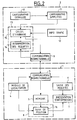
- Figure 2 is a block diagram of a first example of the dynamic guidance system according to the invention, in which the route calculation is performed by the remote server.
- the first mobile communication module 3 is bidirectional, allowing the reciprocal exchange of words and data between the embedded system and the server distant.
- Memory 5 stores the data received from remote server 2, i.e. the route optimal calculated with useful road models for rebuild routes from the database simplified cartographic. For this, she can understand a specific message storage area voice sent by the server.
- the first electronic processing unit 8 provides vehicle position tracking on the route, thanks to a module 16.
- the second module 9 of communication is bidirectional.
- the second electronic processing unit 13 comprises on the one hand, a module 14 for query interpretation of the user, whether in voice form or no, sent by the first communication module 3 on-board device 1. It can consist of means of speech recognition, possibly completed by an operator in case the speech recognition algorithms would fail.
- the operating method of this embodiment particular includes the following phases.
- a first phase of guidance request by the vehicle user, performed by the device on-board 1, includes a step of establishing a communication between its communication module and that of the remote server.
- the user then composes a request, comprising mainly the destination to which the user wants to be guided, as well as several waypoints specified if necessary.
- This request established using the command module 6, is present in the form of electrical signals corresponding to the keys on a keyboard or preferably words converted into signals electric by a microphone.
- the corresponding electrical signals are emitted from a communication module to each other, using a speech or data exchange channel. Simultaneously, the location module 4 sends also the current position of the vehicle.
- a second phase of calculating the route requested by the user enters the current vehicle position and its given destination is performed by the server distant and consists first of all of an interpretation of the user's request by module 14, which translated into commands understandable by module 15 route calculation. In the most case ergonomic where the request is composed of words, it is interpreted by means of recognition of the speech included in module 14. An operator can manually translate the voice command if these the latter are defective.
- the module 15 for calculating an optimal route receives this request mainly composed of the destination to which the user wishes to be guided, possibly with waypoints, and the current location of the vehicle.
- This module 15 queries the cartographic databases 11 and traffic information 12 to deduce a route optimal in time and distance.
- This route consists of coordinates geographic points of the road network, such as crossroads, and sections described using models parametric route. At each point and at each section are associated with text information or corresponding to the directions to follow, the distance from the points of the network to which must be voice information, and the length of these voice messages.
- the communication module 9 transmits these information in module 3 of the on-board device, voice channel and data channel digital.
- a third phase then consists in memorizing, by on-board device 1, all this information transmitted by the remote server 2, in the memory 5.
- a position tracking module 16 belonging to the first processing unit 8 reconstructs the routes the route from parametric models transmitted by the remote server and stored in said memory. This can also be done by the transmission by the server of a simple identifier to point to a list of previously known models of the on-board system, stored in the memory provided for this purpose. The road is determined by applying the model to others data defining the route, such as the equation of the route, its parameters, the conditions ends, etc ....
- position tracking is then capable identify the axis on which the vehicle is traveling and its position on this axis with a view to guiding it towards the designated destination.
- the position tracking module 16 performs the comparison between vehicle journey and route calculated stored in memory 5. As soon as the distance between location and a current decision point is less than message presentation distances also stored in memory 5, the module order position tracking in module 7 of presentation information display of text indications corresponding and the transmission of the voice message.
- the user can also detect an exit from this route and warn the user by visual and audible indications. Indeed, it checks that the vehicle follows the recommended route using parametric models of the road sections. Otherwise, the user can join the recommended route thanks in particular to an indication of direction towards a point of this route, in the form of display of a graphic arrow for example. In another version, the user can send a new guidance request to the remote server 2 which will then recalculate a new route.
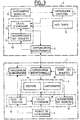
- Figure 3 is a block diagram of a second exemplary embodiment of the system according to the invention, in which the route calculation is carried out by the remote server, with possibility for the device embedded to calculate a route itself in a strip located around the main route.
- an extract from the simplified cartography, stored in remote server 2 is transmitted to device on board the vehicle, this extract corresponding to a displacement band around the calculated route, which covers possible user trips outside this route.
- this mapped strip memorized in the on-board device 1, the latter can calculate a route bringing the vehicle back to the route initial and guide it through the guidance indications contained in this map extract.
- the first module 3 of on-board device communication ensures two-way mobile communication with the remote server 2
- module 4 provides localization of the vehicle in real time
- module 6 allows entry user requests that are interpreted by a module 17 of the electronic processing unit 8, on the on-board device 1.
- This same processing unit further includes a vehicle position tracking module 16 on the route, as well as an on-board calculation module 18 a route from the map extract simplified sent by the server and covering a band of displacement around the route calculated by the server.
- a module 7 provides the presentation of guidance information to the user, by summary voice and display for text data or graphics.
- the memory 5 includes a first zone 19 for memorizing data concerning the route, received from server 2, and a second area 20 to store useful route models for reconstruct the routes of the route from the simplified cartography 11, and an extract from this same simplified cartography 11 corresponding to the band of movement of the vehicle around the calculated route.
- the remote server 2 of the vehicle includes the same elements as in the first embodiment described in connection with figure 2, with a module 9 providing two-way fixed communication.
- the operating method of this second mode of particular realization includes a first phase of guidance request, by the vehicle user, to a destination it indicates with possibly crossing points, from its current location.
- This first phase is identical to the first phase of the embodiment guidance system.
- the method comprises a second phase of calculating a optimal route from the database simplified cartographic map 11 and database 12 traffic information, carried out in the same way by the route calculation module 15 only during the first embodiment of the system.
- this calculation module 15 also determines a travel strip around the route previously calculated, which is an extract from the simplified cartography 11.
- This displacement band can be defined according to geometric criteria, like the bandwidth, which can decrease when you is approaching the destination point, for example. She can also be set according to the length of the route, its width being all the more narrow the route is long, to limit the amount of data to be transmitted and thus achieve a compromise between quality of service and cost of service offered to the user.
- a fourth dynamic guidance phase carried out by the on-board device 1, firstly includes the setting in memory of the route calculated in the first area 19 and the displacement tape in the second zone 20.
- the guidance consists then in a reconstruction of the roads of the route by the position tracking module 16, identification of the vehicle traffic route and the issuance of guidance indications to the destination if the processing unit 8 verifies that the vehicle is on the calculated route.
- This verification is the result of a comparison between the route actually followed by the vehicle and the route calculated using parametric models of roads.
- module 18 recalculates a route for guide him to the initial route then his destination.
- module 7 for presenting information can help him get back there by displaying an arrow indicating the direction of a point on the strip or the destination.
- the user himself can send a new guidance request to the server remote 2, to calculate a new route with a new displacement band.
- the on-board device helps the driver to return to the network of included routes, by display of an arrow indicating a point of the strip travel or destination.
- the dynamic guidance system according to the invention can also be realized according to a third mode particular, in which most of the guidance is performed by the on-board device, while the role from the remote server is to transmit the basics of updated map data.
- the duration of transmission is relatively short thanks to the models parametric routes.
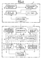
- FIG. 4 is a block diagram of this third embodiment of the invention.
- the device on-board includes a communication module 3, which is unidirectional authorizing communication from the server towards the vehicle in a first case, represented by a simple dotted arrow. It can be based on data dissemination methods, such as the protocol SWIFT for modulation radio broadcasts frequency, or the D.A.B. for example.
- module 3 is no longer just a receiver but is based on a mode of exchange of data expected in some cellular networks of telephony, like the G.S.M. network, authorizing a two-way point-to-point communication between the embedded device and server, shown symbolically by a double arrow in solid line.
- the on-board device includes a module 6 for entering user requests, a presentation module 7 guidance information in the vehicle, a module 4 real-time vehicle location, one unit electronic processing unit 8 comprising a module 17 for interpreting requests received from the input, a module 18 for calculating an optimal route from the commands sent by module 17 and from information stored in memory 5, and a module 16 for tracking the position of the vehicle from its location, route models and the simplified cartography memorized.
- the memory 5 is composed of a first area 19 where various information such as traffic is stored road, a second zone 20 where the simplified mapping from the database 11 of server 2, and a third zone 21 where are stored the road models which can be downloaded at the same time as the cartography simplified.
- the remote server 2 is composed in a first case a transmitter, SWIFT, DAB, etc., broadcasting data, and in a second case of a transceiver compatible with exchange protocols cellular radio network data.
- the operating method of this third mode of particular embodiment of a guidance system according to the invention is based on the transmission of the base of simplified map data 11 to the device on-board 1 in the vehicle, which will perform the calculation optimal route itself as well as guidance vehicle dynamics.
- the first part of the method is to periodically transmit the simplified mapping from remote server 2 to on-board device 1, which stores it in the second area 20 of memory 5.
- This mapping is reset updated periodically by the server including module 9 of communication achieves rapid transmission, thanks to the fact that this simplified mapping 11 uses parametric road models.
- So memory 5 can store a large geographic area, such as the territory of a country, which can be defined as a disc of determined radius having for center the module 9 from the server 2.
- the first unidirectional communication module 3 of the vehicle regularly scans the data sent by the remote server and compare the version of the modeled mapping issued, defined by its number or its modification date, with the saved version in the second memory 20. If the memorized version is earlier than the version issued, it is replaced by the latter in memory.
- mapping simplified road network in geographic areas, like the departments of a country for example.
- the version numbers are managed for each zone cutting module updated and receiving module 3 of the vehicle performs the comparison between the version memorized and the version sent for each one.
- One advantage of this possibility is the emission more frequent from neighboring geographic areas of the transmitter.
- module 9 can contact the vehicle to warn him that a new version of the database is available and module 3 of embedded device 1 can reach the server to request a download of the database cartographic.
- the second part of the operating process of this third embodiment is the realization of the dynamic vehicle guidance according to a procedure classic.
- the communication module 3 of the on-board device 1 scans traffic information sent by server 2 and stores them in a zone temporary memory 21.
- the route calculation module 18 receives the information stored in the memory 5, concerning road traffic and cartography, and determines the optimal route from the position of the vehicle located thanks to module 4 of localization, possibly refined by module 16 position tracking.
- the route calculation being made the guidance takes place and the vehicle position tracking module 16 restores roads around its position. For that, it searches, in a list stored in the third memory area 21, the model corresponding to the model identifier transmitted for each route by the server 2.
- the guidance consists, after this route reconstruction of the route and the identification of the traffic route of the vehicle, to issue guidance indications if the processing unit 8 has verified that the vehicle runs well on the calculated route. This verification is identical to that already described.
- the third embodiment can be based, depending on another variant, on the transmission of the base of simplified cartographic data, broken down into au minus two levels, a first level called “base of global data "which basically includes major traffic axes in a geographical area scope, and a second level called “database locale "which includes a limited area in the vicinity of server 9 transmitter module 2.
- the transmission phase of this database to two levels takes place as follows: everything first, the module 9 periodically transmits the base of global data containing mainly large axes and allowing for example to connect cities between them, thus constituting a database long distance. This overall base can extend to a very large area, like a continent like Europe, using parametric route models. As in the previous variant, the on-board device 1 compare the version of the stored map with the version issued and replaces it if necessary.
- the communication module 9 also broadcasts more detailed mapping of a limited area around the transmitter of each server, corresponding for example to a city encountered on the course of the vehicle. It transmits a corresponding identifier on behalf of the city and a version number for allow the on-board device to update the database saved in the second zone memory 20.
- the unity of on-board device processing compares the map saved in memory 5 to the one that is received and replaces it with this one, automatically or after confirmation by the user, if these mappings are different.
- the dynamic guidance phase takes place differently in a local area and in a larger area.
- the procedure is identical to that described in the first variant of third embodiment.
- the procedure is all first establish a guidance request with input of the destination using module 6, specifying the city and address.
- Module 17 interprets this request and commands module 18 which calculates a optimal route from the database global stored in the second memory area 20, the local database corresponding to the city source stored in area 19 and information on road traffic stored in the third zone memory 21, route intended to reach the city of destination by major highways.
- the address of destination is stored in local memory 19 without to be interpreted. Dynamic guidance between the current location of the vehicle and the city of destination is identical to the guidance described previously.
- module 3 of communication from the on-board device 1 receives, server 2, the local database corresponding to the road network of the region surrounding the server, and the stores in the second memory area 20 of the memory 5.
- the route calculation module 18 compares the destination address stored at the start of the journey with the addresses of the local database. Yes the specified address is unknown in this database, the module 18 signals this to the user who must enter again the desired destination. Then module 18 calculates the optimal route to the destination and performs the guidance described above.
- the user can enter a waypoint among those known to the embedded device in a list saved, displayed on demand. These are for example the border towns located at the limit of the base of embedded data.
- the user instead of designating departure the destination address which is analyzed from that the on-board device receives the database local to the destination, the user does not specifies that the city of destination during the request initial and when the on-board device receives the local database near the destination, it asks the user to enter the address of the destination.
- the dynamic guidance system operates by modeling the roads of the road network. This modeling can be carried out in a compacted form, for example, by a function whose geometric representation approaches the reality of the road to be modeled, by end intersections and a maximum uncertainty which is a function of the distance between the two crossroads, the length of the road, and other parameters.
- the modeling process in a compact form of the road sections of the database is carried out when the cartographic database is constituted definitively.
- a road is a succession of elementary sections or vectors, connected end to end. The more complex the shape of the road, due to bends, the more it is necessary to finely cut the representation of the road, which generates a large number of vectors.
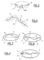
- the road is defined by the geographical coordinates of its ends, that is to say the initial intersection Ci and the final intersection C f , and by its actual length, which defines an ellipse E, d ' maximum uncertainty I max , in which the road R is necessarily situated as shown in FIG. 5.
- the modeling according to the invention makes it possible to significantly reduce the uncertainty on the position of the road without increasing the number of representative segments. For this, it takes into account the fact that a majority of roads have similar shapes, such as straight lines, one or two bends, arc of a circle ..., which can be classified into a small number of road models .
- the principle of this modeling consists in search, among the predefined models, the model closer to the route, by measuring the distance between the road and the model, according to a threshold adjustable in function of the precision sought, called quality of the model Q.
- the route R is composed of two segments S 0 and S 1 inside the ellipse E (FIG. 7).
- the road is made up of three segments, two extreme segments S 2 and S 3 starting from the crossroads ends, whose angles ⁇ 2 and ⁇ 3 of inclination are known relative to the axis of the ellipse d 'uncertainty, and an intermediate segment S 4 connecting them (Figure 8).
- All models can be known in advance from the central server and the on-board device. In this case, a simple model number is sufficient to identify it and only this identifier and the boundary conditions at the ends of each section of road are to be transmitted and stored. Otherwise, the route models must be transmitted to the on-board device with the other data, in a formalism understandable by the latter.
- Parametric modeling of network sections road is definitely done at the level of central server and the same level of service is offered to all users, be adapted dynamically and in real time on the one hand to constraints imposed by communication capacities and processing of the on-board device, and other share the needs of various users, such as precision of the application for example.
- the on-board device To enable this dynamic management of the modeling, the on-board device must communicate, in the request it sends to the remote server, specifications such as desired precision, possibly defined by category of axes, the on-board memory capacity available for save route models, or the ability to processing of models, in order to receive only models that can be treated.
- the server does then transmits the necessary elements, such as main crossroads for example or all crossroads, simple parametric models or complexes, etc ....
Landscapes
- Engineering & Computer Science (AREA)
- Radar, Positioning & Navigation (AREA)
- Remote Sensing (AREA)
- Physics & Mathematics (AREA)
- General Physics & Mathematics (AREA)
- Mathematical Physics (AREA)
- Automation & Control Theory (AREA)
- Navigation (AREA)
Applications Claiming Priority (2)
| Application Number | Priority Date | Filing Date | Title |
|---|---|---|---|
| FR9801235 | 1998-02-03 | ||
| FR9801235A FR2774468B1 (fr) | 1998-02-03 | 1998-02-03 | Systeme et procedes de guidage dynamique d'un vehicule automobile |
Publications (1)
| Publication Number | Publication Date |
|---|---|
| EP0933616A1 true EP0933616A1 (de) | 1999-08-04 |
Family
ID=9522537
Family Applications (1)
| Application Number | Title | Priority Date | Filing Date |
|---|---|---|---|
| EP99400244A Withdrawn EP0933616A1 (de) | 1998-02-03 | 1999-02-03 | Vorrichtung und Verfahren zur dynamischen Automobilenroutenführung |
Country Status (2)
| Country | Link |
|---|---|
| EP (1) | EP0933616A1 (de) |
| FR (1) | FR2774468B1 (de) |
Cited By (14)
| Publication number | Priority date | Publication date | Assignee | Title |
|---|---|---|---|---|
| WO2001001370A1 (en) * | 1999-06-24 | 2001-01-04 | Telia Ab | Map service |
| FR2800184A1 (fr) * | 1999-10-26 | 2001-04-27 | France Telecom | Procede de determination d'un itineraire compris entre un point de depart et un point d'arrivee d'un reseau, tel qu'un reseau routier |
| WO2001098734A1 (de) * | 2000-06-19 | 2001-12-27 | Robert Bosch Gmbh | Verfahren zur auswahl von karteninformationen und navigationsvorrichtung |
| EP1221588A1 (de) * | 2001-01-03 | 2002-07-10 | Motorola, Inc. | Navigationsverfahren |
| FR2827695A1 (fr) * | 2001-07-23 | 2003-01-24 | France Telecom | Portail de services de telecommunications comprenant un serveur avec reconnaissance vocale et equipement de navigation et de guidage utilisant ledit portail |
| EP1288886A3 (de) * | 2001-09-04 | 2004-02-11 | Nissan Motor Company, Limited | Vorrichtung, Verfahren und Programm zur Routenführung von Kraftfahrzeugen |
| EP1408304A1 (de) * | 2002-10-08 | 2004-04-14 | Delphi Technologies, Inc. | System und Methode zur Steuerung von off-board Anwendungen |
| FR2867271A1 (fr) * | 2004-03-08 | 2005-09-09 | France Telecom | Procede de guidage en temps reel d'un vehicule terrestre muni d'un systeme de navigation debarque |
| FR2900231A1 (fr) * | 2006-04-25 | 2007-10-26 | Peugeot Citroen Automobiles Sa | Systeme d'assistance a la navigation d'un utilisateur |
| EP1855087A2 (de) | 2001-03-29 | 2007-11-14 | Intellisist, Inc. | System und Verfahren zur Reduktion des Volumens repetitiver Daten |
| EP1482279A3 (de) * | 2003-05-24 | 2008-04-02 | Jentro Technologies GmbH | Navigationssystem |
| CN112556700A (zh) * | 2019-09-25 | 2021-03-26 | 华为技术有限公司 | 地图级别指示方法、地图级别获取方法及相关产品 |
| FR3152902A1 (fr) * | 2023-09-07 | 2025-03-14 | Psa Automobiles Sa | Procédé de contrôle de rendu d’un texte généré à partir de données textuelles issues d’au moins un système embarqué d’un véhicule. |
| FR3167740A1 (fr) * | 2024-10-18 | 2026-04-24 | Stellantis Auto Sas | Procédé et dispositif de contrôle de rendu d’un texte généré à partir de données textuelles |
Families Citing this family (2)
| Publication number | Priority date | Publication date | Assignee | Title |
|---|---|---|---|---|
| GB2370460A (en) | 2000-12-21 | 2002-06-26 | Nokia Mobile Phones Ltd | Segmented route guidance |
| FR2826111B1 (fr) * | 2001-06-14 | 2003-11-28 | Webraska Mobile Technologies S | Procede d'aide a la navigation routiere, centre de calcul et d'aide a la navigation routiere et serveur d'aide a la navigation routiere pour la mise en oeuvre du procede |
Citations (6)
| Publication number | Priority date | Publication date | Assignee | Title |
|---|---|---|---|---|
| JPH06261149A (ja) * | 1993-03-03 | 1994-09-16 | Nippon Telegr & Teleph Corp <Ntt> | 電話網を利用したナビゲーションシステム |
| WO1995021435A1 (en) * | 1994-02-02 | 1995-08-10 | Rolf Rising | Information system for controlling of vehicles |
| JPH07225897A (ja) * | 1994-02-14 | 1995-08-22 | Csk Corp | 移動体マルチメディア通信システム |
| EP0785535A1 (de) * | 1996-01-16 | 1997-07-23 | Mitsubishi Denki Kabushiki Kaisha | Integriertes Führungssystem für Fahrzeuge |
| EP0810571A1 (de) * | 1996-05-28 | 1997-12-03 | Nec Corporation | Navigationssystem unter Verwendung eines tragbaren Telefons und Navigationsverfahren, das dieses System verwendet |
| EP0811961A1 (de) * | 1996-06-05 | 1997-12-10 | VDO Adolf Schindling AG | Verfahren zur Aufbereitung von dem Führer eines Fahrzeugs zu übermittelnder Wegleitinformation |
-
1998
- 1998-02-03 FR FR9801235A patent/FR2774468B1/fr not_active Expired - Fee Related
-
1999
- 1999-02-03 EP EP99400244A patent/EP0933616A1/de not_active Withdrawn
Patent Citations (6)
| Publication number | Priority date | Publication date | Assignee | Title |
|---|---|---|---|---|
| JPH06261149A (ja) * | 1993-03-03 | 1994-09-16 | Nippon Telegr & Teleph Corp <Ntt> | 電話網を利用したナビゲーションシステム |
| WO1995021435A1 (en) * | 1994-02-02 | 1995-08-10 | Rolf Rising | Information system for controlling of vehicles |
| JPH07225897A (ja) * | 1994-02-14 | 1995-08-22 | Csk Corp | 移動体マルチメディア通信システム |
| EP0785535A1 (de) * | 1996-01-16 | 1997-07-23 | Mitsubishi Denki Kabushiki Kaisha | Integriertes Führungssystem für Fahrzeuge |
| EP0810571A1 (de) * | 1996-05-28 | 1997-12-03 | Nec Corporation | Navigationssystem unter Verwendung eines tragbaren Telefons und Navigationsverfahren, das dieses System verwendet |
| EP0811961A1 (de) * | 1996-06-05 | 1997-12-10 | VDO Adolf Schindling AG | Verfahren zur Aufbereitung von dem Führer eines Fahrzeugs zu übermittelnder Wegleitinformation |
Non-Patent Citations (2)
| Title |
|---|
| PATENT ABSTRACTS OF JAPAN vol. 018, no. 667 (E - 1645) 15 December 1994 (1994-12-15) * |
| PATENT ABSTRACTS OF JAPAN vol. 095, no. 011 26 December 1995 (1995-12-26) * |
Cited By (20)
| Publication number | Priority date | Publication date | Assignee | Title |
|---|---|---|---|---|
| WO2001001370A1 (en) * | 1999-06-24 | 2001-01-04 | Telia Ab | Map service |
| FR2800184A1 (fr) * | 1999-10-26 | 2001-04-27 | France Telecom | Procede de determination d'un itineraire compris entre un point de depart et un point d'arrivee d'un reseau, tel qu'un reseau routier |
| WO2001098734A1 (de) * | 2000-06-19 | 2001-12-27 | Robert Bosch Gmbh | Verfahren zur auswahl von karteninformationen und navigationsvorrichtung |
| US6941221B2 (en) | 2000-06-19 | 2005-09-06 | Robert Bosch Gmbh | Method for selecting map information, and navigation device |
| EP1221588A1 (de) * | 2001-01-03 | 2002-07-10 | Motorola, Inc. | Navigationsverfahren |
| EP2341315A1 (de) * | 2001-01-03 | 2011-07-06 | Motorola Mobility, Inc. | Navigationsverfahren |
| EP1855087A2 (de) | 2001-03-29 | 2007-11-14 | Intellisist, Inc. | System und Verfahren zur Reduktion des Volumens repetitiver Daten |
| US8121781B2 (en) | 2001-03-29 | 2012-02-21 | Wi-Gui, Llp | System and method for reducing the amount of repetitive data sent by a server to a client for vehicle navigation |
| EP1855087A3 (de) * | 2001-03-29 | 2009-03-11 | Intellisist, Inc. | System und Verfahren zur Reduktion des Volumens repetitiver Daten |
| WO2003010494A1 (fr) * | 2001-07-23 | 2003-02-06 | France Telecom | Portail de services de telecommunications comprenant un serveur avec reconnaissance vocale et equipment de navigation et de guidage utilisant ledit portail |
| FR2827695A1 (fr) * | 2001-07-23 | 2003-01-24 | France Telecom | Portail de services de telecommunications comprenant un serveur avec reconnaissance vocale et equipement de navigation et de guidage utilisant ledit portail |
| EP1288886A3 (de) * | 2001-09-04 | 2004-02-11 | Nissan Motor Company, Limited | Vorrichtung, Verfahren und Programm zur Routenführung von Kraftfahrzeugen |
| EP1408304A1 (de) * | 2002-10-08 | 2004-04-14 | Delphi Technologies, Inc. | System und Methode zur Steuerung von off-board Anwendungen |
| EP1482279A3 (de) * | 2003-05-24 | 2008-04-02 | Jentro Technologies GmbH | Navigationssystem |
| EP1577644A1 (de) * | 2004-03-08 | 2005-09-21 | France Telecom | Verfahren zur Echtzeitleitung eines terristrischen Fahrzeugs ausgerüstet mit einem Off-Board-Navigation System |
| FR2867271A1 (fr) * | 2004-03-08 | 2005-09-09 | France Telecom | Procede de guidage en temps reel d'un vehicule terrestre muni d'un systeme de navigation debarque |
| FR2900231A1 (fr) * | 2006-04-25 | 2007-10-26 | Peugeot Citroen Automobiles Sa | Systeme d'assistance a la navigation d'un utilisateur |
| CN112556700A (zh) * | 2019-09-25 | 2021-03-26 | 华为技术有限公司 | 地图级别指示方法、地图级别获取方法及相关产品 |
| FR3152902A1 (fr) * | 2023-09-07 | 2025-03-14 | Psa Automobiles Sa | Procédé de contrôle de rendu d’un texte généré à partir de données textuelles issues d’au moins un système embarqué d’un véhicule. |
| FR3167740A1 (fr) * | 2024-10-18 | 2026-04-24 | Stellantis Auto Sas | Procédé et dispositif de contrôle de rendu d’un texte généré à partir de données textuelles |
Also Published As
| Publication number | Publication date |
|---|---|
| FR2774468A1 (fr) | 1999-08-06 |
| FR2774468B1 (fr) | 2000-03-17 |
Similar Documents
| Publication | Publication Date | Title |
|---|---|---|
| CA2285682C (fr) | Procede interactif d'aide a la navigation et dispositif de mise en oeuvre | |
| EP0933616A1 (de) | Vorrichtung und Verfahren zur dynamischen Automobilenroutenführung | |
| NL2001140C1 (nl) | Een navigatieapparaat en -methode voor het instellen en gebruiken van profielen. | |
| US7627423B2 (en) | Route based on distance | |
| RU2383864C2 (ru) | Навигационное устройство, отображающее информацию о дорожном движении | |
| US7158880B2 (en) | Navigation system | |
| WO2002080131A1 (fr) | Dispositif d'assistance pour vehicule automobile | |
| FR2801158A1 (fr) | Appareil portable comportant des moyens d'orientation procede d'utilisation d'un tel appareil et procede d'orientation correspondant | |
| EP1467181A2 (de) | Navigationssystem | |
| FR2762906A1 (fr) | Procede et dispositif de guidage de vehicule automobile | |
| CN113514075B (zh) | 语音播放方法、装置、终端及存储介质 | |
| FR2697655A1 (fr) | Procédé et dispositif de guidage d'un véhicule sur un plan de circulation. | |
| KR20040032371A (ko) | 네비게이션 시스템, 정보 제공 장치, 교통 정보 생성방법, 및 네비게이션 방법 | |
| FR2826111A1 (fr) | Procede d'aide a la navigation routiere, centre de calcul et d'aide a la navigation routiere et serveur d'aide a la navigation routiere pour la mise en oeuvre du procede | |
| FR2772911A1 (fr) | Procede et dispositifs de restitution d'informations routieres embarques sur vehicule automobile | |
| EP1038283B1 (de) | Navigationshilfsvorrichtung in einem system an bord eines fahrzeugs | |
| EP1667084B1 (de) | Erfassung des gewünschten Halts | |
| FR2800184A1 (fr) | Procede de determination d'un itineraire compris entre un point de depart et un point d'arrivee d'un reseau, tel qu'un reseau routier | |
| EP2115391A1 (de) | Navigationsverfahren für mobile endgeräte mit zentralisiertem server | |
| FR2901602A1 (fr) | Susteme d'assistance a l'orientation | |
| FR2742565A1 (fr) | Procede de filtrage et de restitution d'informations routieres et dispositif de mise en oeuvre du procede | |
| EP1443310B1 (de) | Verfahren und Vorrichung zur geographischen Führung des Benutzers eines Fahrzeuges | |
| HK40053588A (en) | Voice playing method and device, terminal and storage medium | |
| CA3234860A1 (fr) | Systeme de guidage d'un utilisateur par un signal sonore, et procede de guidage correspondant | |
| FR2784776A1 (fr) | Procede de guidage d'un vehicule routier |
Legal Events
| Date | Code | Title | Description |
|---|---|---|---|
| PUAI | Public reference made under article 153(3) epc to a published international application that has entered the european phase |
Free format text: ORIGINAL CODE: 0009012 |
|
| AK | Designated contracting states |
Kind code of ref document: A1 Designated state(s): DE ES GB IT |
|
| AX | Request for extension of the european patent |
Free format text: AL;LT;LV;MK;RO;SI |
|
| RIN1 | Information on inventor provided before grant (corrected) |
Inventor name: MOUSSA,RALPH Inventor name: LETEMPLE, JEAN-PIERRE Inventor name: GRANIER, EMMANUEL |
|
| 17P | Request for examination filed |
Effective date: 20000112 |
|
| AKX | Designation fees paid |
Free format text: DE ES GB IT |
|
| RAP1 | Party data changed (applicant data changed or rights of an application transferred) |
Owner name: RENAULT S.A.S. |
|
| 17Q | First examination report despatched |
Effective date: 20030228 |
|
| STAA | Information on the status of an ep patent application or granted ep patent |
Free format text: STATUS: THE APPLICATION IS DEEMED TO BE WITHDRAWN |
|
| 18D | Application deemed to be withdrawn |
Effective date: 20130125 |