EP0952428A1 - Moyens de calcul d'itinéraire dans un système de navigation - Google Patents
Moyens de calcul d'itinéraire dans un système de navigation Download PDFInfo
- Publication number
- EP0952428A1 EP0952428A1 EP99107901A EP99107901A EP0952428A1 EP 0952428 A1 EP0952428 A1 EP 0952428A1 EP 99107901 A EP99107901 A EP 99107901A EP 99107901 A EP99107901 A EP 99107901A EP 0952428 A1 EP0952428 A1 EP 0952428A1
- Authority
- EP
- European Patent Office
- Prior art keywords
- evaluation
- road
- route
- evaluation values
- navigation system
- Prior art date
- Legal status (The legal status is an assumption and is not a legal conclusion. Google has not performed a legal analysis and makes no representation as to the accuracy of the status listed.)
- Granted
Links
- 238000011156 evaluation Methods 0.000 claims abstract description 61
- 230000004075 alteration Effects 0.000 claims description 8
- 230000006870 function Effects 0.000 claims description 4
- 238000010586 diagram Methods 0.000 description 4
- 238000005259 measurement Methods 0.000 description 1
Images


Classifications
-
- G—PHYSICS
- G01—MEASURING; TESTING
- G01C—MEASURING DISTANCES, LEVELS OR BEARINGS; SURVEYING; NAVIGATION; GYROSCOPIC INSTRUMENTS; PHOTOGRAMMETRY OR VIDEOGRAMMETRY
- G01C21/00—Navigation; Navigational instruments not provided for in groups G01C1/00 - G01C19/00
- G01C21/26—Navigation; Navigational instruments not provided for in groups G01C1/00 - G01C19/00 specially adapted for navigation in a road network
- G01C21/34—Route searching; Route guidance
- G01C21/3453—Special cost functions, i.e. other than distance or default speed limit of road segments
- G01C21/3484—Personalized, e.g. from learned user behaviour or user-defined profiles
Definitions
- the present invention relates to a navigation system for searching for or determining the route from a starting point to a destination.
- a route searching function (see Japanese Patent Kokai Publication No. 01138409). According to this function, when a starting point and a destination are set by an input means or a current position detecting means, calculation for synthetic evaluation is made using, as parameters, the evaluation values of each road segment corresponding to the distance, the number of lanes, the road type, and the like, and the route with the best evaluation is displayed.
- n denotes the segment number of each route.
- the synthetic evaluation is calculated for each of a plurality of routes from the starting point to the destination, by ⁇ (Kn ⁇ Nn ⁇ Dn), and the route having the smallest (best) synthetic evaluation is displayed being high-lighted.
- the setting means may comprise an evaluation value alteration key, and a control circuit responsive to manipulation of the evaluation value alteration key to alter the evaluation values stored in said memory means.
- the segment data includes the data representing a distance, a road type, and the number of lanes.
- Fig. 1 is a block diagram showing pertinent parts of an embodiment of the invention.
- Reference numeral 1 denotes a control circuit, which operates according to programs stored in ROM 2 to control the entire system.
- Reference numeral 3 denotes a GPS (global positioning system) positing measuring means, which receives electromagnetic wave from GPS satellites, and measures the current position, and supplies the measurement data to the control circuit 1.
- GPS global positioning system
- Reference numeral 4 denotes a map reproduction means, which reads map information from a CD-ROM in which map information is recorded, and supplies the map information to the control circuit 1.
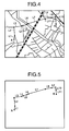
- the map information is divided into a plurality of block groups, and each block group is divided into layers of road network, intersections, names of the place, names of transportation network, such as railroads, and buildings, and the like.
- the road network layer is divided into segments at every intersections.
- the road segments are classified into high-ways, national roads, main local roads and other local roads. For each road segment, the distance, the direction, the time taken to drive, the width of the road, the number of lanes, and the average intervals of traffic signals, and other appendant data are stored (Japanese Patent Kokai Publication No. 01138409).
- Reference numeral 5 denotes a display means, which displays the map, the current position and the like under control by the control circuit 1.
- Reference numeral 6 denotes a RAM (random access memory), which stores the data necessary for the operation of the control circuit 1, such as the current position 61, detected by the GPS measuring means 3, the route history 62 (starting points, destinations, routes) including the actual route which the user has run along, and the planned routes set in the past, and the evaluation values 63 used for the calculation for searching for the route (see Fig. 2A and Fig. 2B).
- Reference numeral 7 denotes an input means, which includes a cursor key 71 for scrolling the screen in eight directions, a return key 72 for causing the output of data to the control circuit 1, a route setting key 73 for setting the planned route, and an evaluation value alteration key 74 for altering the evaluation values.
- Fig. 3 is a flowchart showing the operation of the control circuit 1.
- the control circuit 1 monitors to see whether the evaluation value alteration key 74 has been manipulated, or whether the route setting key 73 has been manipulated (S1, S2).
- the control circuit 1 causes a screen for altering the evaluation values for the segment data, such as the number of lanes, and the types of roads (S3), and causes rewriting in the RAM 6 of the evaluation values having been altered by the manipulation of the cursor key 71 and the return key 76 (S4).
- Fig. 2A and Fig. 2B show an example of alteration made when the user wants to reach the destination as early as possible. It is seen that the high ways and the number of lanes are taken as more significant than with the initial values.
- the evaluation values used for the calculation for the search can be altered according to the situation or according to the user.
- the control circuit 1 When it is found that the route setting key 73 has been manipulated at the step S2, the control circuit 1 causes display of a list of the existing route history stored in the RAM 6, and an icon for newly setting a planned route (S5). The user then input to indicate whether one of the existing routes is selected, or the planned route is newly set.
- a screen for prompting input of the starting point and the destination is displayed (S9).
- the evaluation values for the road segment data such as the number of lanes and the type of the road are read (S11), and the synthetic evaluation of each route from the starting point to destination is calculated using the evaluation values having been read (S12).
- the routes for which the evaluation is made are limited to those satisfying certain conditions. For instance a route including a road segment which is more than 120 degrees with respect to the direction from the starting point to destination (i.e., the road segment which leads the user farther away from the destination) is excluded.
- the evaluation values of the road segment data of the respective road segments are multiplied, and summed up.
- calculation of the synthetic evaluation of the route consisting of road segments L1 to L11 is made.
- the synthetic evaluation of each route is calculated (S12), and the route having the smallest (best) synthetic evaluation is selected (S13).
- the selected route and the starting point and the destination are stored in the RAM 6 as a precedent (S14).
- the selected route is displayed with a certain color (S15).
- the route having been stored as the precedent can be displayed at the above mentioned step S8 when desired by the user.
- the synthetic evaluation of the route is determined based on the distance, the number of lanes, and the road type, according to ⁇ (Kn x Nn x Dn).
- the evaluation may be made on road segment data other than the distance, the number of lanes and the road type. For instance, the average running speed, traffic regulations, or average intervals between traffic signals may be used.
- the formula used for the determination of the synthetic evaluation may be other than ⁇ (Kn x Nn x Dn), and may be ⁇ (coefficient No. 1 x Kn + coefficient No. 2 x Nn + coefficient No. 3 x Dn).
- segment data other than Kn, Nn and Dn This applies to segment data other than Kn, Nn and Dn, and the coefficients may be altered.
- the evaluation values for automatically searching for the route can be altered by the user, so that it is possible to cope with the difference in the evaluation by the user, and the difference in the evaluation depending on the situation. For instance, it is possible to cope with the user who takes the difference between a two-lane road and a three-lane road significant, and the situation in which the user is in a hurry so that the merit of a high way is significant, and a situation in which the user has a plenty of time so that the merit of a high way is not so high.
Landscapes
- Engineering & Computer Science (AREA)
- Radar, Positioning & Navigation (AREA)
- Remote Sensing (AREA)
- Health & Medical Sciences (AREA)
- General Health & Medical Sciences (AREA)
- Social Psychology (AREA)
- Automation & Control Theory (AREA)
- Physics & Mathematics (AREA)
- General Physics & Mathematics (AREA)
- Navigation (AREA)
- Traffic Control Systems (AREA)
- Instructional Devices (AREA)
Applications Claiming Priority (2)
| Application Number | Priority Date | Filing Date | Title |
|---|---|---|---|
| JP10112094A JPH11304518A (ja) | 1998-04-22 | 1998-04-22 | ナビゲーション装置 |
| JP11209498 | 1998-04-22 |
Publications (2)
| Publication Number | Publication Date |
|---|---|
| EP0952428A1 true EP0952428A1 (fr) | 1999-10-27 |
| EP0952428B1 EP0952428B1 (fr) | 2005-06-15 |
Family
ID=14577978
Family Applications (1)
| Application Number | Title | Priority Date | Filing Date |
|---|---|---|---|
| EP99107901A Expired - Lifetime EP0952428B1 (fr) | 1998-04-22 | 1999-04-21 | Système de navigation |
Country Status (4)
| Country | Link |
|---|---|
| US (1) | US6175805B1 (fr) |
| EP (1) | EP0952428B1 (fr) |
| JP (1) | JPH11304518A (fr) |
| DE (1) | DE69925777T2 (fr) |
Cited By (4)
| Publication number | Priority date | Publication date | Assignee | Title |
|---|---|---|---|---|
| EP1402231A4 (fr) * | 2000-02-16 | 2007-03-14 | Televigation Inc | Procede et systeme permettant d'obtenir un environnement operationnel efficace dans un systeme de navigation en temps reel |
| US7389179B2 (en) | 2001-01-24 | 2008-06-17 | Telenav, Inc. | Real-time navigation system for mobile environment |
| US7415576B2 (en) | 2002-09-30 | 2008-08-19 | Renesas Technology Corp. | Data processor with block transfer control |
| WO2015134417A1 (fr) | 2014-03-03 | 2015-09-11 | Inrix Inc | Personnalisation de commandes automatiques d'un véhicule |
Families Citing this family (23)
| Publication number | Priority date | Publication date | Assignee | Title |
|---|---|---|---|---|
| US6415227B1 (en) * | 1999-04-21 | 2002-07-02 | American Gnc Corporation | Enhanced global positioning system and map navigation process |
| JP3327264B2 (ja) * | 1999-10-13 | 2002-09-24 | 株式会社デンソー | 経路設定装置及びナビゲーション装置 |
| US6405128B1 (en) * | 1999-12-20 | 2002-06-11 | Navigation Technologies Corp. | Method and system for providing an electronic horizon in an advanced driver assistance system architecture |
| CN1714275B (zh) * | 2003-07-16 | 2012-02-22 | 哈曼贝克自动系统股份有限公司 | 导航系统及在导航系统中确定路线的方法 |
| US20060095171A1 (en) * | 2004-11-02 | 2006-05-04 | Whittaker William L | Methods, devices and systems for high-speed autonomous vehicle and high-speed autonomous vehicle |
| FI118614B (fi) * | 2005-12-27 | 2008-01-15 | Navicore Oy | Menetelmä virheiden havaitsemiseksi navigointidatassa |
| US7523418B2 (en) * | 2006-03-15 | 2009-04-21 | International Business Machines Corporation | Techniques for choosing a position on a display having a cursor |
| JP4554653B2 (ja) * | 2007-08-08 | 2010-09-29 | クラリオン株式会社 | 経路探索方法、経路探索システムおよびナビゲーション装置 |
| JP5334719B2 (ja) * | 2009-07-10 | 2013-11-06 | カヤバ工業株式会社 | ハイブリッド建設機械の制御装置 |
| US8645060B2 (en) | 2010-09-07 | 2014-02-04 | Qualcomm Incorporated | Positioning network availability and reliability based routing |
| TWI442353B (zh) * | 2010-12-06 | 2014-06-21 | Mitac Int Corp | 根據導航路徑上的興趣點提供導航路徑之方法及相關裝置 |
| US9533654B2 (en) * | 2010-12-17 | 2017-01-03 | GM Global Technology Operations LLC | Vehicle data services enabled by low power FM transmission |
| US8972172B2 (en) * | 2011-05-03 | 2015-03-03 | International Business Machines Corporation | Wireless sensor network traffic navigation analytics |
| US8981995B2 (en) | 2011-06-03 | 2015-03-17 | Microsoft Technology Licensing, Llc. | Low accuracy positional data by detecting improbable samples |
| JP5466201B2 (ja) * | 2011-06-08 | 2014-04-09 | トヨタ自動車株式会社 | 電気自動車 |
| US9464903B2 (en) | 2011-07-14 | 2016-10-11 | Microsoft Technology Licensing, Llc | Crowd sourcing based on dead reckoning |
| US9470529B2 (en) | 2011-07-14 | 2016-10-18 | Microsoft Technology Licensing, Llc | Activating and deactivating sensors for dead reckoning |
| US10184798B2 (en) | 2011-10-28 | 2019-01-22 | Microsoft Technology Licensing, Llc | Multi-stage dead reckoning for crowd sourcing |
| US9290107B2 (en) * | 2011-11-29 | 2016-03-22 | Ruijie Shi | System and method for energy management in an electric vehicle |
| US9429657B2 (en) | 2011-12-14 | 2016-08-30 | Microsoft Technology Licensing, Llc | Power efficient activation of a device movement sensor module |
| US9817125B2 (en) | 2012-09-07 | 2017-11-14 | Microsoft Technology Licensing, Llc | Estimating and predicting structures proximate to a mobile device |
| US10215586B2 (en) * | 2013-06-01 | 2019-02-26 | Apple Inc. | Location based features for commute assistant |
| CN113267192B (zh) * | 2021-05-26 | 2023-04-14 | 海南太美航空股份有限公司 | 提高交叉航线渲染效率的方法及系统 |
Citations (5)
| Publication number | Priority date | Publication date | Assignee | Title |
|---|---|---|---|---|
| EP0547548A1 (fr) * | 1991-12-18 | 1993-06-23 | Honda Giken Kogyo Kabushiki Kaisha | Dispositif de guidage de voyage pour véhicule |
| EP0703436A2 (fr) * | 1994-09-22 | 1996-03-27 | Aisin Aw Co., Ltd. | Système de navigation pour véhicules |
| EP0726447A1 (fr) * | 1995-02-09 | 1996-08-14 | Zexel Corporation | Calcul de route incrémental |
| EP0751376A2 (fr) * | 1995-06-28 | 1997-01-02 | Aisin Aw Co., Ltd. | Appareil pour navigation véhiculaire |
| EP0805337A2 (fr) * | 1996-05-02 | 1997-11-05 | Pioneer Electronic Corporation | Méthode et appareil pour chercher une destination dans un système de navigation |
Family Cites Families (5)
| Publication number | Priority date | Publication date | Assignee | Title |
|---|---|---|---|---|
| JP2812361B2 (ja) | 1987-11-24 | 1998-10-22 | 住友電気工業株式会社 | 車載型ナビゲーションシステム |
| JP3414873B2 (ja) * | 1995-01-20 | 2003-06-09 | 三菱電機株式会社 | 車載用ナビゲーション装置 |
| US5878368A (en) * | 1996-09-13 | 1999-03-02 | Magellan Dis, Inc. | Navigation system with user definable cost values |
| JP3698835B2 (ja) * | 1996-10-25 | 2005-09-21 | 三菱電機株式会社 | 交通情報表示装置及びその表示方法並びに交通情報表示装置用表示制御プログラムを記録した媒体 |
| US5862509A (en) * | 1996-12-20 | 1999-01-19 | Zexel Corporation | Vehicle navigation using timed turn and timed lane restrictions |
-
1998
- 1998-04-22 JP JP10112094A patent/JPH11304518A/ja active Pending
-
1999
- 1999-04-12 US US09/290,490 patent/US6175805B1/en not_active Expired - Lifetime
- 1999-04-21 DE DE69925777T patent/DE69925777T2/de not_active Expired - Lifetime
- 1999-04-21 EP EP99107901A patent/EP0952428B1/fr not_active Expired - Lifetime
Patent Citations (5)
| Publication number | Priority date | Publication date | Assignee | Title |
|---|---|---|---|---|
| EP0547548A1 (fr) * | 1991-12-18 | 1993-06-23 | Honda Giken Kogyo Kabushiki Kaisha | Dispositif de guidage de voyage pour véhicule |
| EP0703436A2 (fr) * | 1994-09-22 | 1996-03-27 | Aisin Aw Co., Ltd. | Système de navigation pour véhicules |
| EP0726447A1 (fr) * | 1995-02-09 | 1996-08-14 | Zexel Corporation | Calcul de route incrémental |
| EP0751376A2 (fr) * | 1995-06-28 | 1997-01-02 | Aisin Aw Co., Ltd. | Appareil pour navigation véhiculaire |
| EP0805337A2 (fr) * | 1996-05-02 | 1997-11-05 | Pioneer Electronic Corporation | Méthode et appareil pour chercher une destination dans un système de navigation |
Non-Patent Citations (1)
| Title |
|---|
| GUZOLEK J ET AL: "REAL-TIME ROUTE PLANNING IN ROAD NETWORKS", PROCEEDINGS OF THE VEHICLE NAVIGATION AND INFORMATION SYSTEMS CONFERENCE. (VNIS), TORONTO, SEPT. 11 - 13, 1989, no. CONF. 1, 11 September 1989 (1989-09-11), REEKIE D;CASE E; TSAI J, pages 165 - 169, XP000089883 * |
Cited By (7)
| Publication number | Priority date | Publication date | Assignee | Title |
|---|---|---|---|---|
| EP1402231A4 (fr) * | 2000-02-16 | 2007-03-14 | Televigation Inc | Procede et systeme permettant d'obtenir un environnement operationnel efficace dans un systeme de navigation en temps reel |
| EP2261607A3 (fr) * | 2000-02-16 | 2013-08-07 | TeleNav, Inc. | Méthode et système pour la détermination d'un trajet préféré dans un système de navigation |
| US7389179B2 (en) | 2001-01-24 | 2008-06-17 | Telenav, Inc. | Real-time navigation system for mobile environment |
| US7415576B2 (en) | 2002-09-30 | 2008-08-19 | Renesas Technology Corp. | Data processor with block transfer control |
| WO2015134417A1 (fr) | 2014-03-03 | 2015-09-11 | Inrix Inc | Personnalisation de commandes automatiques d'un véhicule |
| EP3114559A4 (fr) * | 2014-03-03 | 2018-01-03 | Inrix, Inc. | Personnalisation de commandes automatiques d'un véhicule |
| US11292476B2 (en) | 2014-03-03 | 2022-04-05 | Inrix Inc. | Personalization of automated vehicle control |
Also Published As
| Publication number | Publication date |
|---|---|
| JPH11304518A (ja) | 1999-11-05 |
| DE69925777T2 (de) | 2006-05-18 |
| DE69925777D1 (de) | 2005-07-21 |
| EP0952428B1 (fr) | 2005-06-15 |
| US6175805B1 (en) | 2001-01-16 |
Similar Documents
| Publication | Publication Date | Title |
|---|---|---|
| EP0952428B1 (fr) | Système de navigation | |
| EP0848232B1 (fr) | Appareil de base de données cartographiques | |
| EP1826532B1 (fr) | Système de navigation | |
| US5506779A (en) | Route searching apparatus | |
| US5486822A (en) | Optimum route determination | |
| US5878368A (en) | Navigation system with user definable cost values | |
| EP1505370B1 (fr) | Procédé de traitement de données cartographiques numériques | |
| JP4591395B2 (ja) | ナビゲーションシステム | |
| EP1288885B1 (fr) | Procédé et appareil de traitement d'informations routières | |
| JP3754110B2 (ja) | 動的経路探索方法およびナビゲーション装置 | |
| US6366834B1 (en) | Time display method and apparatus | |
| EP2075546A2 (fr) | Dispositif de navigation et logiciel | |
| US20120004836A1 (en) | Method of Estimation of Traffic Information, Device of Estimation of Traffic Information and Car Navigation Device | |
| EP0760504A2 (fr) | Appareil de base de données cartographiques | |
| US20050222758A1 (en) | Car navigation system | |
| KR19990083509A (ko) | 경로탐색장치 | |
| US6820003B2 (en) | Navigation apparatus | |
| EP1413855A2 (fr) | Appareil pour fournir des routes, procédé pour fournir des routes, système de navigation, et logiciel pour l'appareil pour fournir des routes ou pour le système de navigation | |
| EP1630524B1 (fr) | Dispositif de navigation, structure de données et procédé de recherche et d'affichage d'itinéraire | |
| JP2003021528A (ja) | ナビゲーション装置、到着時刻算出方法、及びプログラム | |
| JP3193479B2 (ja) | 経路誘導方法 | |
| JP3443246B2 (ja) | 車載用ナビゲーション装置 | |
| JP2902209B2 (ja) | 経路探索方法 | |
| JP3069202B2 (ja) | 経路探索方法 | |
| JPH09101169A (ja) | 車載用ナビゲーション装置 |
Legal Events
| Date | Code | Title | Description |
|---|---|---|---|
| PUAI | Public reference made under article 153(3) epc to a published international application that has entered the european phase |
Free format text: ORIGINAL CODE: 0009012 |
|
| AK | Designated contracting states |
Kind code of ref document: A1 Designated state(s): DE FR NL |
|
| AX | Request for extension of the european patent |
Free format text: AL;LT;LV;MK;RO;SI |
|
| 17P | Request for examination filed |
Effective date: 20000403 |
|
| AKX | Designation fees paid |
Free format text: DE FR NL |
|
| 17Q | First examination report despatched |
Effective date: 20030729 |
|
| GRAP | Despatch of communication of intention to grant a patent |
Free format text: ORIGINAL CODE: EPIDOSNIGR1 |
|
| RTI1 | Title (correction) |
Free format text: NAVIGATION SYSTEM |
|
| GRAS | Grant fee paid |
Free format text: ORIGINAL CODE: EPIDOSNIGR3 |
|
| GRAA | (expected) grant |
Free format text: ORIGINAL CODE: 0009210 |
|
| AK | Designated contracting states |
Kind code of ref document: B1 Designated state(s): DE FR NL |
|
| REF | Corresponds to: |
Ref document number: 69925777 Country of ref document: DE Date of ref document: 20050721 Kind code of ref document: P |
|
| ET | Fr: translation filed | ||
| PLBE | No opposition filed within time limit |
Free format text: ORIGINAL CODE: 0009261 |
|
| STAA | Information on the status of an ep patent application or granted ep patent |
Free format text: STATUS: NO OPPOSITION FILED WITHIN TIME LIMIT |
|
| 26N | No opposition filed |
Effective date: 20060316 |
|
| PGFP | Annual fee paid to national office [announced via postgrant information from national office to epo] |
Ref country code: FR Payment date: 20110426 Year of fee payment: 13 Ref country code: DE Payment date: 20110413 Year of fee payment: 13 |
|
| PGFP | Annual fee paid to national office [announced via postgrant information from national office to epo] |
Ref country code: NL Payment date: 20110426 Year of fee payment: 13 |
|
| REG | Reference to a national code |
Ref country code: NL Ref legal event code: V1 Effective date: 20121101 |
|
| REG | Reference to a national code |
Ref country code: FR Ref legal event code: ST Effective date: 20121228 |
|
| PG25 | Lapsed in a contracting state [announced via postgrant information from national office to epo] |
Ref country code: FR Free format text: LAPSE BECAUSE OF NON-PAYMENT OF DUE FEES Effective date: 20120430 |
|
| REG | Reference to a national code |
Ref country code: DE Ref legal event code: R119 Ref document number: 69925777 Country of ref document: DE Effective date: 20121101 |
|
| PG25 | Lapsed in a contracting state [announced via postgrant information from national office to epo] |
Ref country code: NL Free format text: LAPSE BECAUSE OF NON-PAYMENT OF DUE FEES Effective date: 20121101 |
|
| PG25 | Lapsed in a contracting state [announced via postgrant information from national office to epo] |
Ref country code: DE Free format text: LAPSE BECAUSE OF NON-PAYMENT OF DUE FEES Effective date: 20121101 |