EP1004041B1 - Procede de traitement de donnees sismiques - Google Patents
Procede de traitement de donnees sismiques Download PDFInfo
- Publication number
- EP1004041B1 EP1004041B1 EP98938803A EP98938803A EP1004041B1 EP 1004041 B1 EP1004041 B1 EP 1004041B1 EP 98938803 A EP98938803 A EP 98938803A EP 98938803 A EP98938803 A EP 98938803A EP 1004041 B1 EP1004041 B1 EP 1004041B1
- Authority
- EP
- European Patent Office
- Prior art keywords
- seismic
- raypath
- raypaths
- alternative
- propagation model
- Prior art date
- Legal status (The legal status is an assumption and is not a legal conclusion. Google has not performed a legal analysis and makes no representation as to the accuracy of the status listed.)
- Expired - Lifetime
Links
Images

Classifications
-
- G—PHYSICS
- G01—MEASURING; TESTING
- G01V—GEOPHYSICS; GRAVITATIONAL MEASUREMENTS; DETECTING MASSES OR OBJECTS; TAGS
- G01V1/00—Seismology; Seismic or acoustic prospecting or detecting
- G01V1/28—Processing seismic data, e.g. for interpretation or for event detection
- G01V1/282—Application of seismic models, synthetic seismograms
-
- G—PHYSICS
- G01—MEASURING; TESTING
- G01V—GEOPHYSICS; GRAVITATIONAL MEASUREMENTS; DETECTING MASSES OR OBJECTS; TAGS
- G01V2210/00—Details of seismic processing or analysis
- G01V2210/60—Analysis
- G01V2210/67—Wave propagation modeling
- G01V2210/671—Raytracing
Definitions
- the present invention relates to a method of processing seismic data.
- Seismic data is collected in order to analyse the sub-surface of the earth, in particular for hydrocarbon exploration.
- Seismic data for analysing sub-surface structures may be collected on land or, over water, using sea-going vessels.
- a seismic source which may comprise explosives (on land) or an impulse of compressed air or airguns (at sea) is provided.
- the seismic data signals reflected by the various layers beneath the surface of the earth are known as traces and are sensed by a large number, typically hundreds, of sensors such as geophones on land and hydrophones at sea.
- the reflected signals are recorded and the results are analysed to derive an indication of the layer formations beneath the sub-surface. Such indications may then be used to assess the likelihood of hydrocarbon deposits.
- shortest path Some of these methods are commonly (and confusingly) referred to as "shortest path” methods, although they actually compute a shortest travel-time path, rather than a shortest physical ray length path. Articles describing this type of method may also be found in Geophysics, Volume 56, No. 1, January 1991, T.J. Moser, "Shortest path calculation of seismic rays", pages 59-67; Geophysics, Volume 58, No. 7, July 1993, Robert Fischer et al., "Shortest path ray tracing with sparse graphs", pages 987-996; and Geophysics, Volume 59, No. 7, July 1994, T.J. Moser, “Migration using the shortest-path method", pages 1110-1120.
- references to the process of computing the shortest travel-time raypath can be found in these articles on page 59, abstract, line 4; page 987, column 2, line 20; and page 1111, column 2, line 37, respectively.
- Another prior art technique is to select the arrival having the maximum amplitude.
- selection of this arrival is not necessarily straightforward because the model of the sub-surface will generally only be approximate.
- the maximum amplitude arrival will only provide the best single arrival as long as the estimates of amplitude are correct.
- Another difficulty with the maximum amplitude arrival is that the choice of arrival can switch rapidly back and forth between branches.
- improvements using the maximum-amplitude arrival over use of a first arrival have been observed in the prior art reference first identified above.
- a method of processing seismic data using a seismic energy propagation model of the subsurface including: assigning seismic source, seismic receiver, and reflection point locations to the propagation model; identifying alternative raypaths that originate at the seismic source location, reflect at the reflection point location, and terminate at the seismic receiver location; selecting a raypath having a shortest ray length; and utilizing the selected raypath in subsequent seismic processing.
- the shortest ray-path length criterion will virtually never result in a low amplitude signal. While the physical length of the ray will vary in response to changes in the velocity model, the physical ray length is less susceptible to such changes than is the estimate of the amplitude. The reason for this is that amplitude is related to the curvature of the rays. Thus small errors in the ray paths can produce large errors in the amplitudes.
- the ray-length is an integral quantity (the integral of arc length along the ray) so it is relatively insensitive to small perturbations in the ray path. In other words, the choice of a particular ray using the technique of the present invention is less likely to switch rapidly than the maximum amplitude technique. This provides a much more reliable assumption upon which to base subsequent processing than either of the prior art techniques.
- a seismic source S for example an explosive
- a seismic source S is located on the surface of the earth together with a plurality of geophones R1 to R5.
- geophones R1 to R5 typically, there will be hundreds of geophones arranged in a two dimensional or a three dimensional array over the surface of the earth. For simplicity, only five geophones R1 to R5 are shown.
- Seismic signal paths are shown in broken lines between the source S and the geophones R1 to R5 via subsurface layers L1, L2, and L3. The ray paths are shown reflecting from a number of horizons H1, H2, and H3. Only some of the ray paths are shown for clarity.
- the seismic signals will travel at different speeds in the layers (typically the speed of propagation will increase with an increase in depth) it is not straightforward to locate the horizons H1, H2, and H3.
- the data from each horizon is generally separated and a seismic energy propagation model (i.e. an estimate of the subsurface acoustic velocities) of the subsurface being analysed is applied to derive an estimate of the actual reflecting (or "imaging") point on a horizon beneath the surface.
- prestack depth migration involves simultaneously adding together multiple samples to increase the signal to noise ratio of the data (similar to a conventional "stacking" procedure), moving seismic events to compensate for the offset distance between the source and the receiver (similar to a conventional "normal move-out correction” procedure), and moving seismic events to compensate for inclined seismic reflectors (similar to a conventional "migration” procedure).
- Prestack imaging of seismic data is usually implemented using an integral formulation in the time space domain.
- reflection point is used throughout this application, this phrase may be more fully be understood as being an "image point", i.e. a subsurface location illuminated by the raypath in question.
- the raypath from the source to the image point and from the image point to the receiver will have an abrupt change of directions at the image point. While this change of direction is referred to as being a “reflection” throughout this application, it may also be thought of as being “scattered” at the image point.
- the seismic energy propagation model may not incorporate any assumptions regarding reflector dip (inclination) angles in the vicinity of the image point and the "downgoing" ray from the source to the image point is not necessarily required to have a seismic reflector incidence angle that is equal and opposite to the seismic reflector incidence angle of the "upgoing" ray from the image point to the receiver.
- the image at any point is computed from an integral over a surface in the prestack data.
- the traveltimes and weight functions depend on a model that is an estimate of the subsurface properties.
- the integral is evaluated over all source and receiver co-ordinates. The traveltimes define a trajectory in the data over which the integral takes
- the traveltimes may be calculated by many methods (e.g. finite difference methods, gridded travel time approximation methods, ray-tracing). Most of these methods solve a high frequency approximation to the wave equation which decouples the solution into two parts, first solving the eikonal equation for the traveltimes and then solving the transport equation for the amplitudes.
- the eikonal equation is an equation that results from asymptotic expansion of the wave equation. It is a non-linear differential equation that is satisfied by the traveltimes. All of the methods either explicitly or implicitly calculate the ray-path which is the path that the energy travels along between the source or receiver and the image point.
- Ray-tracing methods often inherently calculate travel distances as they select alternative ray-paths or provide outputs that allow the travel distances of the various ray-paths to be easily calculated.
- FIG. 2 shows one example of a complex model that gives rise to multivalued traveltimes.
- a seismic source S is being used to analyse an image I at a point beneath the surface 10 of the earth.
- the salt bodies 12, 14 refract the seismic rays and provide two further paths 16, 20 between the source S and the image I.
- the two salt bodies thus produce refracted ray paths from the source to the image point in addition to the direct ray path that does not travel through the salt.
- One prior art technique as discussed briefly above is to use the first arrival because it is easier to calculate and it is guaranteed to be a continuous function.
- the first arrival may contain very little energy and is thus not always a suitable choice.
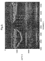
- Figure 3 shows a post-analysis seismic image in which the horizontal axis shows a distance (in feet) along the surface from the origin of the survey.
- the vertical axis shows the depth (in feet) beneath the surface of, in this case, a water layer that extends to 6000 feet.
- the traveltimes used in building this image were created using a finite difference solution to the well known eikonal equation.
- the pre-stack migration was performed using the first arrival at the seismic receiver.
- many of the features are somewhat hazy.
- the salt bodies can be responsible for refracted ray paths and this can result in low energy levels in the first arrival.
- the images of the layers in this model are consequently poorly defined.
- the grid-like features at a distance between approximately 40,000 and 60,000 feet and a depth between approximately 9,000 and 17,000 feet are poorly defined.
- the analysis based on the first arrival also provides poor resolution of these comparatively small features.
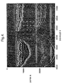
- Figure 4 shows a seismic image covering the same distance and depth and derived from the same seismic model as the image shown in Figure 3.
- the maximum amplitude arrival was selected for pre-stack migration and subsequent stacking.
- Figure 3 it can be seen that almost every feature in the image is sharper.
- the two horizontal layers at approximately 17,000 feet and 27,000 feet respectively have also been reconstructed rather more clearly than in the image based on the first arrival.
- those parts of the two layers identified in the discussion of the previous image are still reconstructed somewhat unclearly.
- the lower layer (27,000 feet) is reconstructed somewhat vaguely over the range between approximately 32,000 to 44,000 feet from the origin of the survey.
- the small grid of features arranged at a distance between approximately 40,000 and 60,000 feet are substantially clearer
- the present invention provides a new criterion for selecting the signal traveltime to be used for imaging.
- the traveltime that is selected is that associated with the ray that has shortest physical length. This ray is often the highest amplitude arrival but this is not guaranteed. More importantly, it is almost never a low amplitude first arrival associated with refracted energy.
- the physical length criterion is much more stable with respect to small fluctuations in the velocity model or to changes in the model because it is an integral quantity as discussed above.
- the traveltime from the shortest ray is not a continuous function. It is, however, piecewise continuous. In addition, because it is more stable, it tends to consist of a few large pieces with well defined boundaries between them. In contrast, the result of using maximum amplitudes tends to be a much more "broken up" trajectory consisting of lots of small segments with rapid switching back and forth between branches.
- the piecewise continuous function provided by the shortest ray has other advantages (e.g. it is associated with more of the energy).
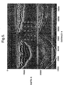
- Figure 5 shows a further image corresponding to those of Figure 3 and Figure 4 and being derived from the same seismic model.
- the pre-stack migration has been performed using the shortest ray length rather than the ray corresponding with the first arrival or the maximum amplitude arrival.
- Figure 3 it can readily be seen that the image provided using shortest-ray prestack migration results in a much clearer image than selection of the first arrival. The improvement of this image over that derived using the maximum amplitude arrival is not quite so marked but an improvement nonetheless exists.
- the reconstruction of the layers at approximately 17,000 feet and 27,000 feet respectively is improved.
- the reconstruction of the upper layer has improved clarity, especially between approximately 32,000 feet and 50,000 feet from the origin of the survey.
- the selected raypath is used in prestack depth migration for two primary purposes, to establish an acoustic pulse arrival time and to calculate an estimate of the amplitude of the arrival. These values may be used, for instance, to determine which input sample from a seismic trace acquired at the particular receiver location and associated with an acoustic pulse from the particular source location will be used to calculate the output sample associated with the image point, as well as the weight that will be applied to the input sample.
- Figures 3, 4, and 5 show two dimensional cross-sections of the subsurface, they have been created using a three dimensional set of seismic data.
- the prestack depth migration algorithm used to develop these sections is a true three dimensional method that does not assume that the acoustic energy transmitted from the source to the receiver travels in the vertical plane connecting these points or that the image point must reside in this vertical plane. This consideration of "out-of-plane" energy both increases the quality of the seismic image obtained as well as increasing the complexity of properly processing the data.
- the selected raypath may also be used to update the seismic energy propagation model of the subsurface (i.e. the velocity model).
- the inventive method may be used in an identical manner with pressure-shear (P-S) mode seismic data (as well as shear-shear (S-S) mode and other seismic energy transmission modes) simply by providing a seismic energy propagation model of the subsurface that accounts for these alternative seismic energy transmission modes.
- P-P pressure-pressure
- S-S shear-shear
Landscapes
- Engineering & Computer Science (AREA)
- Remote Sensing (AREA)
- Physics & Mathematics (AREA)
- Life Sciences & Earth Sciences (AREA)
- Acoustics & Sound (AREA)
- Environmental & Geological Engineering (AREA)
- Geology (AREA)
- General Life Sciences & Earth Sciences (AREA)
- General Physics & Mathematics (AREA)
- Geophysics (AREA)
- Geophysics And Detection Of Objects (AREA)
Claims (10)
- Procédé pour traiter des données sismiques en utilisant un modèle de propagation d'énergie sismique du sous-sol, ledit procédé comportant les étapes consistant à :assigner audit modèle de propagation les emplacements d'une source sismique, d'un récepteur sismique et d'un point de réflexion,identifier une pluralité de trajets de rayon différents compatibles avec ledit modèle de propagation qui prennent leur origine au niveau de l'emplacement de ladite source sismique, se réfléchissent au niveau de l'emplacement dudit point de réflexion, et se terminent au niveau de l'emplacement dudit récepteur sismique,sélectionner un trajet de rayon parmi ladite pluralité de trajets de rayon différents ayant une longueur de la plus courte, etutiliser ledit trajet sélectionné lors du traitement sismique effectué ensuite.
- Procédé selon la revendication 1, dans lequel ladite étape de sélection d'un trajet de rayon comprend le calcul, de distances de propagation pour chacun desdits différents trajets de rayon et la comparaison desdites distances de propagation calculées afin de déterminer lequel desdits différents trajets de rayon possède ladite distance de propagation la plus courte.
- Procédé selon l'une quelconque des revendications précédentes, dans lequel les trajets de ladite pluralité de trajets de rayon différents sont identifiés par une procédure de traçage de rayons.
- Procédé selon l'une quelconque des revendications précédentes, dans lequel ledit modèle de propagation est un modèle tridimensionnel et les trajets de ladite pluralité de trajets de rayon différents ne sont pas coplanaires.
- Procédé selon l'une quelconque des revendications précédentes, dans lequel ledit trajet de rayon sélectionné est utilisé pour calculer un temps d'arrivée d'impulsion acoustique.
- Procédé selon l'une quelconque des revendications précédentes, dans lequel ledit trajet de rayon sélectionné est utilisé pour estimer une amplitude d'arrivée.
- Procédé selon l'une quelconque des revendications précédentes, dans lequel ledit trajet de rayon sélectionné est utilisé pour sélectionner un échantillon à partir d'une trace sismique acquise au niveau de l'emplacement dudit récepteur sismique associée à une impulsion acoustique provenant de l'emplacement de ladite source sismique, ledit échantillon étant utilisé pour créer une image dudit point de réflexion.
- Procédé selon la revendication 7, dans lequel ledit trajet de rayon sélectionné est utilisé pour calculer un poids à appliquer audit échantillon.
- Procédé selon l'une quelconque des revendications précédentes, dans lequel ledit modèle de propagation modélise la transmission d'énergie sismique en mode pression-pression (P-P) dans la formation géologique souterraine.
- Procédé selon l'une quelconque des revendications 1 à 8, dans lequel ledit modèle de propagation modélise la transmission d'énergie sismique en mode pression-cisaillement ("Pressure-Shear" ou P-S) dans la formation géologique souterraine.
Applications Claiming Priority (3)
| Application Number | Priority Date | Filing Date | Title |
|---|---|---|---|
| GB9717409 | 1997-08-15 | ||
| GBGB9717409.8A GB9717409D0 (en) | 1997-08-15 | 1997-08-15 | A method of processing seismic data |
| PCT/GB1998/002428 WO1999009434A1 (fr) | 1997-08-15 | 1998-08-12 | Procede de traitement de donnees sismiques |
Publications (2)
| Publication Number | Publication Date |
|---|---|
| EP1004041A1 EP1004041A1 (fr) | 2000-05-31 |
| EP1004041B1 true EP1004041B1 (fr) | 2001-11-14 |
Family
ID=10817605
Family Applications (1)
| Application Number | Title | Priority Date | Filing Date |
|---|---|---|---|
| EP98938803A Expired - Lifetime EP1004041B1 (fr) | 1997-08-15 | 1998-08-12 | Procede de traitement de donnees sismiques |
Country Status (10)
| Country | Link |
|---|---|
| US (1) | US6950790B1 (fr) |
| EP (1) | EP1004041B1 (fr) |
| CN (1) | CN1146732C (fr) |
| AU (1) | AU733509B2 (fr) |
| CA (1) | CA2298542C (fr) |
| DE (1) | DE69802547T2 (fr) |
| EA (1) | EA001707B1 (fr) |
| GB (2) | GB9717409D0 (fr) |
| NO (1) | NO330788B1 (fr) |
| WO (1) | WO1999009434A1 (fr) |
Families Citing this family (13)
| Publication number | Priority date | Publication date | Assignee | Title |
|---|---|---|---|---|
| GB2368911A (en) * | 2000-11-09 | 2002-05-15 | Geco Prakla | Computing a stacked seismic line by interpolation between known stacks |
| GB2409900B (en) | 2004-01-09 | 2006-05-24 | Statoil Asa | Processing seismic data representing a physical system |
| GB2412741B (en) * | 2004-04-03 | 2009-02-25 | Statoil Asa | Electromagnetic data processing |
| GB2420855B (en) | 2004-12-02 | 2009-08-26 | Electromagnetic Geoservices As | Source for electromagnetic surveying |
| CN100349003C (zh) * | 2004-12-29 | 2007-11-14 | 中国石油天然气集团公司 | 一种消除起伏地表成像误差的方法 |
| GB2435693A (en) | 2006-02-09 | 2007-09-05 | Electromagnetic Geoservices As | Seabed electromagnetic surveying |
| GB2436626B (en) * | 2006-03-28 | 2008-08-06 | Westerngeco Seismic Holdings | Method of evaluating the interaction between a wavefield and a solid body |
| GB2439378B (en) | 2006-06-09 | 2011-03-16 | Electromagnetic Geoservices As | Instrument for measuring electromagnetic signals |
| GB2442749B (en) | 2006-10-12 | 2010-05-19 | Electromagnetic Geoservices As | Positioning system |
| GB2445582A (en) | 2007-01-09 | 2008-07-16 | Statoil Asa | Method for analysing data from an electromagnetic survey |
| CN106569279B (zh) * | 2015-10-12 | 2018-08-07 | 中国石油化工股份有限公司 | 用于修正三维最短射线追踪路径的方法和装置 |
| CN105334532B (zh) * | 2015-10-21 | 2018-04-06 | 中国石油化工股份有限公司 | 一种地震子波估计方法 |
| CN110297272A (zh) * | 2019-07-05 | 2019-10-01 | 中南大学 | 三维速度模型生成方法、装置、设备及存储介质 |
Family Cites Families (3)
| Publication number | Priority date | Publication date | Assignee | Title |
|---|---|---|---|---|
| GB1463060A (en) * | 1973-02-27 | 1977-02-02 | Seiscom Ltd | Synthetic display of seismic reflection strength |
| US5062086A (en) * | 1990-08-27 | 1991-10-29 | Conoco Inc. | Calculation of raypaths and wavepaths from traveltime tables for the tomographic estimation of transmission velocities |
| US6081482A (en) * | 1996-05-09 | 2000-06-27 | 3Dgeo Development, Inc. | Semi-recursive imaging under complex velocity structures |
-
1997
- 1997-08-15 GB GBGB9717409.8A patent/GB9717409D0/en not_active Ceased
-
1998
- 1998-08-12 GB GB0000637A patent/GB2342997B/en not_active Expired - Lifetime
- 1998-08-12 DE DE69802547T patent/DE69802547T2/de not_active Expired - Fee Related
- 1998-08-12 US US09/463,765 patent/US6950790B1/en not_active Expired - Fee Related
- 1998-08-12 CN CNB988080214A patent/CN1146732C/zh not_active Expired - Fee Related
- 1998-08-12 WO PCT/GB1998/002428 patent/WO1999009434A1/fr not_active Ceased
- 1998-08-12 EA EA200000218A patent/EA001707B1/ru not_active IP Right Cessation
- 1998-08-12 AU AU87404/98A patent/AU733509B2/en not_active Expired
- 1998-08-12 CA CA002298542A patent/CA2298542C/fr not_active Expired - Fee Related
- 1998-08-12 EP EP98938803A patent/EP1004041B1/fr not_active Expired - Lifetime
-
2000
- 2000-02-03 NO NO20000564A patent/NO330788B1/no not_active IP Right Cessation
Also Published As
| Publication number | Publication date |
|---|---|
| DE69802547D1 (de) | 2001-12-20 |
| EP1004041A1 (fr) | 2000-05-31 |
| CN1146732C (zh) | 2004-04-21 |
| GB2342997B (en) | 2001-10-17 |
| AU733509B2 (en) | 2001-05-17 |
| NO330788B1 (no) | 2011-07-18 |
| EA200000218A1 (ru) | 2000-08-28 |
| GB9717409D0 (en) | 1997-10-22 |
| CA2298542A1 (fr) | 1999-02-25 |
| AU8740498A (en) | 1999-03-08 |
| GB0000637D0 (en) | 2000-03-01 |
| NO20000564D0 (no) | 2000-02-03 |
| EA001707B1 (ru) | 2001-06-25 |
| GB2342997A (en) | 2000-04-26 |
| US6950790B1 (en) | 2005-09-27 |
| CN1266497A (zh) | 2000-09-13 |
| CA2298542C (fr) | 2003-10-07 |
| DE69802547T2 (de) | 2002-08-08 |
| NO20000564L (no) | 2000-02-03 |
| WO1999009434A1 (fr) | 1999-02-25 |
Similar Documents
| Publication | Publication Date | Title |
|---|---|---|
| US8174926B2 (en) | Method for wavefield separation for dual-sensor data using kirchhoff-type datuming and migration | |
| US8472674B2 (en) | Method of surface seismic imaging using both reflected and transmitted waves | |
| AU2009230788B2 (en) | Method of wavefield extrapolation for single-station, dual-sensor towed streamer signals | |
| US7508736B2 (en) | Vector migration of 1st order free-surface related downgoing multiples from VSP data | |
| US5521881A (en) | Method of processing seismic data having multiple reflection noise | |
| US6067275A (en) | Method of analyzing pre-stack seismic data | |
| US7957221B2 (en) | Method for optimum combination of pressure and particle motion sensors for a 3-D spread of dual-sensor marine seismic streamers | |
| US8811113B2 (en) | Method of summing dual-sensor towed streamer signals using seismic reflection velocities | |
| CA1330235C (fr) | Methode de traitement de donnees sismiques | |
| RU2282877C2 (ru) | Способ корректировки сейсмических данных при морской сейсмической разведке | |
| US7542373B2 (en) | Vector 3-component 3-dimensional kirchhoff prestack migration | |
| EP1004041B1 (fr) | Procede de traitement de donnees sismiques | |
| CA1311830C (fr) | Methode permettant d'augmenter l'efficacite de l'exploration souterraine par le procede vsp | |
| AU674578B2 (en) | Method for datumizing seismic data by forward modeling | |
| Al-Shamsi et al. | Pilot study of multi-component ocean bottom seismic in the Arabian Gulf. | |
| Sengbush | Introduction to Seismic Methods | |
| Galilei | Velocity Estimation | |
| TABAKOV et al. | DIPSCAN technology for estimation of boundaries dips and azimuths in VSP method | |
| AU2005242215A1 (en) | Wide Aperture Seismic Interpretation | |
| NO309746B1 (no) | Fremgangsmåte ved behandling av seismiske data med multippel refleksjonsstöy |
Legal Events
| Date | Code | Title | Description |
|---|---|---|---|
| PUAI | Public reference made under article 153(3) epc to a published international application that has entered the european phase |
Free format text: ORIGINAL CODE: 0009012 |
|
| 17P | Request for examination filed |
Effective date: 20000121 |
|
| AK | Designated contracting states |
Kind code of ref document: A1 Designated state(s): DE FR IT NL |
|
| GRAG | Despatch of communication of intention to grant |
Free format text: ORIGINAL CODE: EPIDOS AGRA |
|
| GRAG | Despatch of communication of intention to grant |
Free format text: ORIGINAL CODE: EPIDOS AGRA |
|
| GRAH | Despatch of communication of intention to grant a patent |
Free format text: ORIGINAL CODE: EPIDOS IGRA |
|
| 17Q | First examination report despatched |
Effective date: 20010426 |
|
| GRAH | Despatch of communication of intention to grant a patent |
Free format text: ORIGINAL CODE: EPIDOS IGRA |
|
| GRAA | (expected) grant |
Free format text: ORIGINAL CODE: 0009210 |
|
| AK | Designated contracting states |
Kind code of ref document: B1 Designated state(s): DE FR IT NL |
|
| REF | Corresponds to: |
Ref document number: 69802547 Country of ref document: DE Date of ref document: 20011220 |
|
| PLBE | No opposition filed within time limit |
Free format text: ORIGINAL CODE: 0009261 |
|
| STAA | Information on the status of an ep patent application or granted ep patent |
Free format text: STATUS: NO OPPOSITION FILED WITHIN TIME LIMIT |
|
| 26N | No opposition filed | ||
| PGFP | Annual fee paid to national office [announced via postgrant information from national office to epo] |
Ref country code: FR Payment date: 20030808 Year of fee payment: 6 |
|
| PGFP | Annual fee paid to national office [announced via postgrant information from national office to epo] |
Ref country code: DE Payment date: 20030822 Year of fee payment: 6 |
|
| PG25 | Lapsed in a contracting state [announced via postgrant information from national office to epo] |
Ref country code: DE Free format text: LAPSE BECAUSE OF NON-PAYMENT OF DUE FEES Effective date: 20050301 |
|
| PG25 | Lapsed in a contracting state [announced via postgrant information from national office to epo] |
Ref country code: FR Free format text: LAPSE BECAUSE OF NON-PAYMENT OF DUE FEES Effective date: 20050429 |
|
| REG | Reference to a national code |
Ref country code: FR Ref legal event code: ST |
|
| PGFP | Annual fee paid to national office [announced via postgrant information from national office to epo] |
Ref country code: NL Payment date: 20080803 Year of fee payment: 11 |
|
| PGFP | Annual fee paid to national office [announced via postgrant information from national office to epo] |
Ref country code: IT Payment date: 20080829 Year of fee payment: 11 |
|
| REG | Reference to a national code |
Ref country code: NL Ref legal event code: V1 Effective date: 20100301 |
|
| PG25 | Lapsed in a contracting state [announced via postgrant information from national office to epo] |
Ref country code: NL Free format text: LAPSE BECAUSE OF NON-PAYMENT OF DUE FEES Effective date: 20100301 |
|
| PG25 | Lapsed in a contracting state [announced via postgrant information from national office to epo] |
Ref country code: IT Free format text: LAPSE BECAUSE OF NON-PAYMENT OF DUE FEES Effective date: 20090812 |