EP1010966A1 - Méthode pour générer une description tridimensionelle d' un objet - Google Patents
Méthode pour générer une description tridimensionelle d' un objet Download PDFInfo
- Publication number
- EP1010966A1 EP1010966A1 EP99123877A EP99123877A EP1010966A1 EP 1010966 A1 EP1010966 A1 EP 1010966A1 EP 99123877 A EP99123877 A EP 99123877A EP 99123877 A EP99123877 A EP 99123877A EP 1010966 A1 EP1010966 A1 EP 1010966A1
- Authority
- EP
- European Patent Office
- Prior art keywords
- data
- dimensional
- orthophoto
- specific
- hybrid
- Prior art date
- Legal status (The legal status is an assumption and is not a legal conclusion. Google has not performed a legal analysis and makes no representation as to the accuracy of the status listed.)
- Granted
Links
- 238000000034 method Methods 0.000 title claims abstract description 33
- 238000012545 processing Methods 0.000 claims abstract description 16
- 230000005540 biological transmission Effects 0.000 claims description 32
- 238000004364 calculation method Methods 0.000 claims description 7
- 238000013144 data compression Methods 0.000 claims description 2
- 238000003703 image analysis method Methods 0.000 claims description 2
- 238000012546 transfer Methods 0.000 abstract description 2
- 238000005259 measurement Methods 0.000 description 5
- 238000009418 renovation Methods 0.000 description 4
- 238000011161 development Methods 0.000 description 3
- 230000018109 developmental process Effects 0.000 description 3
- 238000011156 evaluation Methods 0.000 description 3
- 239000000463 material Substances 0.000 description 3
- 238000001514 detection method Methods 0.000 description 2
- 230000002452 interceptive effect Effects 0.000 description 2
- 239000000969 carrier Substances 0.000 description 1
- 238000013479 data entry Methods 0.000 description 1
- 238000013461 design Methods 0.000 description 1
- 238000010191 image analysis Methods 0.000 description 1
- 239000003550 marker Substances 0.000 description 1
- 238000000691 measurement method Methods 0.000 description 1
- 238000012821 model calculation Methods 0.000 description 1
Images



Classifications
-
- G—PHYSICS
- G01—MEASURING; TESTING
- G01C—MEASURING DISTANCES, LEVELS OR BEARINGS; SURVEYING; NAVIGATION; GYROSCOPIC INSTRUMENTS; PHOTOGRAMMETRY OR VIDEOGRAMMETRY
- G01C11/00—Photogrammetry or videogrammetry, e.g. stereogrammetry; Photographic surveying
- G01C11/04—Interpretation of pictures
- G01C11/06—Interpretation of pictures by comparison of two or more pictures of the same area
Definitions
- the subject of these measurement methods is the three-dimensional description of spatial objects located on the earth's surface, in particular of spatially limited land and structures such as streets, residential and Industrial buildings or other buildings, based on aerial photographs.
- the fact that each of the objects stereoscopic aerial photo pairs, d. H. two aerial photographs each with stereoscopic coverage are recorded you get sets of two-dimensional, geometric image data as well Parameter data, the highly accurate information about the relative recording angle the aerial photo pairs, absolute recording coordinates and others Inclusion parameters included.
- This data forms the raw data for the calculation realistic, oriented representations of the earth's surface.
- By scanning of the individual aerial photos in an electronic data processing system you get digital, two-dimensional image data.
- Considering the stereoscopic parameter data are generated by aerotriangulation oriented aerial photos with altitude information calculated. That way three-dimensional object data from the original raw data won, which form a three-dimensional object description.
- the three-dimensional object data has so far been used in data processing systems saved and are available for further evaluations.
- the achievable measuring accuracy allows it without further ado, buildings and Building parts for the acquisition of basic data for constructional and architectural Record and present measures with sufficient accuracy.
- all relevant can be used to renovate a house roof Information such as roof shape, roof area, roof pitch including any Peculiarities can be determined with sufficient precision so that based on this It is already possible to create a measurement.
- the invention is therefore based on the task, the required Computing effort to generate three-dimensional object descriptions to reduce and reduce the total amount of data generated so far, that user-friendly data transmission over long-distance data lines relatively low capacity is enabled.
- this refers to handling of aerial data via telephone lines in the World Wild Web (Internet).
- data protection aspects manageable handling of the object descriptions may be possible.
- a particular advantage of the method according to the invention results from that not, as was previously the case, a complete three-dimensional object database is generated, but initially only a two-dimensional one Orthophoto database, i.e. an area-wide two-dimensional projection.
- the data processing effort in the generation, handling and Saving this two-dimensional image data is significantly less than if the raw data immediately and completely three-dimensional would be processed.
- the orthophoto data is drawn in structured external factual data.
- the result will be object-specific Orthophoto hybrid records formed.
- factual data for example, cadastral data, street and / or other building data in Question.
- the two-dimensional orthophoto data will be together with this external factual data in a specific Object-associated orthophoto hybrid data record saved.
- the aforementioned Orthophoto hybrid data sets are used in the following process step on a host computer, d. H. a server.
- a host computer d. H. a server.
- This is via data transmission lines in a network-shaped data processing system involved.
- This can be both a local area network in one Be a company, as well as a decentralized, extensive network, such as for example the global structure of the internet.
- To the data transmission lines A large number of client computers are connected via the data transmission lines access the data of the or Have host computers.
- the Orthophoto hybrid data sets will be available in the next step on request any client computer connected to the network.
- the manageable amount of data of the two-dimensional image data enables large-scale aerial photo excerpts even via data transmission lines to be transmitted with limited transmission capacity. For example it is conceivable, on request the image representation of a town or district via Internet, d. H. to be transmitted to the customer via telephone line.
- the next process step relates to the selection of an object-specific Orthophoto hybrid data record on the client computer.
- the Users on the client computer d. H. the customer, for example by entering the address, select a specific building.
- a particular advantage of The inventive method is that no longer - as before - laboriously identifying a building in an aerial view, but only the object-specific property data can be entered for selection, for example street name and house number. This is to select one object-specific orthophoto hybrid data set completely sufficient.
- Material data is now transmitted via the data transmission line from the client computer transferred to the host computer. All of them are there original three-dimensional raw data in a stored form.
- Orders sent are now first three-dimensional in the host computer
- the three-dimensional raw data is now in the host computer a three-dimensional model calculation for the selected object carried out.
- the result is a three-dimensional object data record generated, which together with the object-specific property data a complete forms a three-dimensional object description from an aerial perspective.
- Concrete such a three-dimensional object description can be accurate, for example Include information about the shape and area of a house roof, including data for roof pitch, arrangement and size of windows and chimneys and the like.
- the object data prepared in this way are included the associated property data as a three-dimensional object description the data transmission lines are transmitted to the client.
- a transmission of three-dimensional data via the data transmission line which may have a low transmission capacity can.
- the amount of data actually sent is relatively small, since the description only refers to a specific object. The technical effort is therefore also significantly less than at this point in the state of the art.
- the external factual data expediently contain those already mentioned Road or cadastral data.
- any external data that is in some form associated with the related object, to which factual data are added are added.
- certain agricultural uses are climatic or meteorological data interesting, while for the development of Residential or holiday areas local immission data can be important.
- the addition of additional external factual data can make sense his.
- a graphic and / or alphanumeric representation can be displayed on the client computer the object description.
- the processing expediently goes the measurement data in the host computer so far that further processing is not required at the client. For example, the customer receives extensive Dimensions regarding a house roof, which the material and Cost calculation for the renovation of a roof by a roofer concern.
- the method according to the invention for the first time makes a wide range of users given the opportunity to hand over aerial data for spatial measurement and description of specific objects. This is done at the Basis that first a two-dimensional preparation of the by Measurement of raw data initially obtained takes place.
- the received limited amount of data is, after structuring by integrating external Material data, ideal for handling in a network-shaped, decentralized Data processing system, especially with transmission lines less Transmission capacity, such as the Internet, is ideally suited.
- the method according to the invention finds a particularly advantageous application when planning house roof renovations.
- it forms Roof of the building is the object for which a spatial object description is created.
- Cadastral data or coordinates may be included.
- the determination of the roof shape and / or the roof area can be done in the host computer by means of partially or fully automated image analysis processes. In order to time-consuming manual processing is eliminated.
- the orthophoto data are preferably graphical on the client computer shown.
- This display is particularly user-friendly, if at the same time the physical data of the Orthophoto hybrid data records are displayed graphically, d. H. in the Orthophoto data can be displayed.
- the outline of roof surfaces it is conceivable to use the outline of roof surfaces to mark the objects graphically, for example by highlighting them in color allow. This display is particularly user-friendly.
- the graphic representation of the orthophoto hybrid data records not only the orthophoto hybrid data and the Real data is graphically displayed together on the client computer, but it also form a graphical user interface, with each specific orthophoto hybrid data sets can be selected graphically and interactively.
- a marker becomes interactive, such as such as a mouse pointer, using appropriate input devices via the graphic displayed on the screen moves and for example the Mark the desired roof area by clicking on it. This is already an order issued for the preparation of an object description.
- three-dimensional object data Before the calculation and transmission of the object-specific, three-dimensional object data installed a security query to prevent unauthorized access. This also allows a service for measuring house roofs over a public data network offer and bill. Data protection issues can also be be fully taken into account.
- Fig. 1 shows the orthophotographic generated from a corresponding pair of aerial photographs Representation of a variety of house roofs. According to the The method according to the invention is this image in the form of two-dimensional Orthophoto data stored in a host computer, which, for example, ans Internet is connected.
- the image section shown is only chosen for the sake of clarity.
- the Client computer that is connected to the aforementioned host computer via data lines is connected, for example the Illustration of individual buildings, a street or an entire district be retrieved.
- the Orthophoto data are based on external factual data, for example street information plus structured house numbers.
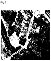
- 2 is graphical in FIG. 1 Orthophoto record shown by using such external Factual data prepared for an Orthophoto hybrid data set. Is exemplary a street section is graphically highlighted by the light line. In addition a single building is graphically marked by a circle. The customer, d. H. the end user on the client computer has a corresponding design User interface the ability through interactive graphical data entry for example to select the building marked with the circle.
- the Orthophoto hybrid data set can also become a technical graphic be prepared with indication of dimensions, as shown in Fig. 3.
- the three-dimensional object description calculated from this is alternatively output in a flat, two-dimensional graphic, as in FIG. 3, and / or in a perspective, spatial representation, as in FIG. 4, and transmitted to the client computer.
- the factual data are prepared and added to the transmitted image data in alphanumeric form.
- the roof area is given in m 2 to give a first impression of the scope of a necessary roof renovation.
- the data to be transmitted are compressed by the Limit effort.
- Security queries are expediently interposed, to prevent unauthorized use and the To be able to bill the service.
Landscapes
- Engineering & Computer Science (AREA)
- Multimedia (AREA)
- Physics & Mathematics (AREA)
- General Physics & Mathematics (AREA)
- Radar, Positioning & Navigation (AREA)
- Remote Sensing (AREA)
- Processing Or Creating Images (AREA)
- Transition And Organic Metals Composition Catalysts For Addition Polymerization (AREA)
- Heating, Cooling, Or Curing Plastics Or The Like In General (AREA)
- Image Processing (AREA)
- Image Generation (AREA)
Applications Claiming Priority (2)
| Application Number | Priority Date | Filing Date | Title |
|---|---|---|---|
| DE19857667A DE19857667A1 (de) | 1998-12-15 | 1998-12-15 | Verfahren zur Erzeugung einer drei-dimensionalen Objektbeschreibung |
| DE19857667 | 1998-12-15 |
Publications (2)
| Publication Number | Publication Date |
|---|---|
| EP1010966A1 true EP1010966A1 (fr) | 2000-06-21 |
| EP1010966B1 EP1010966B1 (fr) | 2002-10-23 |
Family
ID=7891049
Family Applications (1)
| Application Number | Title | Priority Date | Filing Date |
|---|---|---|---|
| EP99123877A Expired - Lifetime EP1010966B1 (fr) | 1998-12-15 | 1999-12-02 | Méthode pour générer une description tridimensionelle d' un objet |
Country Status (5)
| Country | Link |
|---|---|
| EP (1) | EP1010966B1 (fr) |
| AT (1) | ATE226719T1 (fr) |
| DE (2) | DE19857667A1 (fr) |
| DK (1) | DK1010966T3 (fr) |
| ES (1) | ES2186294T3 (fr) |
Cited By (29)
| Publication number | Priority date | Publication date | Assignee | Title |
|---|---|---|---|---|
| US8452125B2 (en) | 2006-08-30 | 2013-05-28 | Pictometry International Corp. | Mosaic oblique images and methods of making and using same |
| WO2013082280A1 (fr) | 2011-11-29 | 2013-06-06 | Pictometry International Corp. | Système pour la détection automatique d'empreintes de structure à partir d'imagerie oblique |
| US20130311240A1 (en) * | 2007-04-17 | 2013-11-21 | Eagle View Technologies, Inc. | Aerial roof estimation system and method |
| US8648872B2 (en) | 2007-12-03 | 2014-02-11 | Pictometry International Corp. | Systems and methods for rapid three-dimensional modeling with real facade texture |
| US9182657B2 (en) | 2002-11-08 | 2015-11-10 | Pictometry International Corp. | Method and apparatus for capturing, geolocating and measuring oblique images |
| US9501700B2 (en) | 2012-02-15 | 2016-11-22 | Xactware Solutions, Inc. | System and method for construction estimation using aerial images |
| US9612598B2 (en) | 2014-01-10 | 2017-04-04 | Pictometry International Corp. | Unmanned aircraft structure evaluation system and method |
| US9633425B2 (en) | 2007-05-01 | 2017-04-25 | Pictometry International Corp. | System for detecting image abnormalities |
| US9679227B2 (en) | 2013-08-02 | 2017-06-13 | Xactware Solutions, Inc. | System and method for detecting features in aerial images using disparity mapping and segmentation techniques |
| US9753950B2 (en) | 2013-03-15 | 2017-09-05 | Pictometry International Corp. | Virtual property reporting for automatic structure detection |
| US9805059B2 (en) | 2013-03-15 | 2017-10-31 | Pictometry International Corp. | System and method for early access to captured images |
| US9881163B2 (en) | 2013-03-12 | 2018-01-30 | Pictometry International Corp. | System and method for performing sensitive geo-spatial processing in non-sensitive operator environments |
| US9898802B2 (en) | 2008-08-05 | 2018-02-20 | Pictometry International Corp. | Cut line steering methods for forming a mosaic image of a geographical area |
| US9933254B2 (en) | 2009-05-22 | 2018-04-03 | Pictometry International Corp. | System and process for roof measurement using aerial imagery |
| US9953112B2 (en) | 2014-02-08 | 2018-04-24 | Pictometry International Corp. | Method and system for displaying room interiors on a floor plan |
| US10325350B2 (en) | 2011-06-10 | 2019-06-18 | Pictometry International Corp. | System and method for forming a video stream containing GIS data in real-time |
| US10338222B2 (en) | 2014-01-31 | 2019-07-02 | Pictometry International Corp. | Augmented three dimensional point collection of vertical structures |
| US10346935B2 (en) | 2012-03-19 | 2019-07-09 | Pictometry International Corp. | Medium and method for quick square roof reporting |
| US10402676B2 (en) | 2016-02-15 | 2019-09-03 | Pictometry International Corp. | Automated system and methodology for feature extraction |
| US10455197B2 (en) | 2010-07-07 | 2019-10-22 | Pictometry International Corp. | Real-time moving platform management system |
| US10502813B2 (en) | 2013-03-12 | 2019-12-10 | Pictometry International Corp. | LiDAR system producing multiple scan paths and method of making and using same |
| US10580169B2 (en) | 2007-10-12 | 2020-03-03 | Pictometry International Corp. | System and process for color-balancing a series of oblique images |
| US10621463B2 (en) | 2010-12-17 | 2020-04-14 | Pictometry International Corp. | Systems and methods for processing images with edge detection and snap-to feature |
| US10671648B2 (en) | 2016-02-22 | 2020-06-02 | Eagle View Technologies, Inc. | Integrated centralized property database systems and methods |
| US10909757B2 (en) | 2018-06-15 | 2021-02-02 | Geomni, Inc. | Computer vision systems and methods for modeling roofs of structures using two-dimensional and partial three-dimensional data |
| US11094113B2 (en) | 2019-12-04 | 2021-08-17 | Geomni, Inc. | Systems and methods for modeling structures using point clouds derived from stereoscopic image pairs |
| US11423614B2 (en) | 2010-02-01 | 2022-08-23 | Eagle View Technologies, Inc. | Geometric correction of rough wireframe models derived from photographs |
| US12079013B2 (en) | 2016-01-08 | 2024-09-03 | Pictometry International Corp. | Systems and methods for taking, processing, retrieving, and displaying images from unmanned aerial vehicles |
| US12332660B2 (en) | 2018-11-21 | 2025-06-17 | Eagle View Technologies, Inc. | Navigating unmanned aircraft using pitch |
Families Citing this family (16)
| Publication number | Priority date | Publication date | Assignee | Title |
|---|---|---|---|---|
| US8078436B2 (en) | 2007-04-17 | 2011-12-13 | Eagle View Technologies, Inc. | Aerial roof estimation systems and methods |
| US8209152B2 (en) | 2008-10-31 | 2012-06-26 | Eagleview Technologies, Inc. | Concurrent display systems and methods for aerial roof estimation |
| US8170840B2 (en) | 2008-10-31 | 2012-05-01 | Eagle View Technologies, Inc. | Pitch determination systems and methods for aerial roof estimation |
| US8731234B1 (en) | 2008-10-31 | 2014-05-20 | Eagle View Technologies, Inc. | Automated roof identification systems and methods |
| US9330494B2 (en) | 2009-10-26 | 2016-05-03 | Pictometry International Corp. | Method for the automatic material classification and texture simulation for 3D models |
| US10515414B2 (en) | 2012-02-03 | 2019-12-24 | Eagle View Technologies, Inc. | Systems and methods for performing a risk management assessment of a property |
| US8774525B2 (en) | 2012-02-03 | 2014-07-08 | Eagle View Technologies, Inc. | Systems and methods for estimation of building floor area |
| US12140419B2 (en) | 2012-02-03 | 2024-11-12 | Eagle View Technologies, Inc. | Systems and methods for estimation of building wall area and producing a wall estimation report |
| US9933257B2 (en) | 2012-02-03 | 2018-04-03 | Eagle View Technologies, Inc. | Systems and methods for estimation of building wall area |
| US10663294B2 (en) | 2012-02-03 | 2020-05-26 | Eagle View Technologies, Inc. | Systems and methods for estimation of building wall area and producing a wall estimation report |
| US9599466B2 (en) | 2012-02-03 | 2017-03-21 | Eagle View Technologies, Inc. | Systems and methods for estimation of building wall area |
| US10909482B2 (en) | 2013-03-15 | 2021-02-02 | Pictometry International Corp. | Building materials estimation |
| US9959581B2 (en) | 2013-03-15 | 2018-05-01 | Eagle View Technologies, Inc. | Property management on a smartphone |
| US11587176B2 (en) | 2013-03-15 | 2023-02-21 | Eagle View Technologies, Inc. | Price estimation model |
| US10127670B2 (en) | 2016-09-27 | 2018-11-13 | Xactware Solutions, Inc. | Computer vision systems and methods for detecting and modeling features of structures in images |
| US10503843B2 (en) | 2017-12-19 | 2019-12-10 | Eagle View Technologies, Inc. | Supervised automatic roof modeling |
Citations (2)
| Publication number | Priority date | Publication date | Assignee | Title |
|---|---|---|---|---|
| DE4419359A1 (de) * | 1994-06-03 | 1995-12-07 | Wolfram Dipl Ing Kirchner | Verfahren zur Erfassung, Auswertung, Ausmessung und Speicherung von Geo-Informationen |
| DE19719620A1 (de) * | 1997-05-09 | 1998-11-12 | Christian Angermann | Verfahren zur Erstellung, Bearbeitung und Nutzung von Luftaufnahmen |
-
1998
- 1998-12-15 DE DE19857667A patent/DE19857667A1/de not_active Withdrawn
-
1999
- 1999-12-02 DK DK99123877T patent/DK1010966T3/da active
- 1999-12-02 DE DE59903157T patent/DE59903157D1/de not_active Expired - Lifetime
- 1999-12-02 EP EP99123877A patent/EP1010966B1/fr not_active Expired - Lifetime
- 1999-12-02 AT AT99123877T patent/ATE226719T1/de not_active IP Right Cessation
- 1999-12-02 ES ES99123877T patent/ES2186294T3/es not_active Expired - Lifetime
Patent Citations (2)
| Publication number | Priority date | Publication date | Assignee | Title |
|---|---|---|---|---|
| DE4419359A1 (de) * | 1994-06-03 | 1995-12-07 | Wolfram Dipl Ing Kirchner | Verfahren zur Erfassung, Auswertung, Ausmessung und Speicherung von Geo-Informationen |
| DE19719620A1 (de) * | 1997-05-09 | 1998-11-12 | Christian Angermann | Verfahren zur Erstellung, Bearbeitung und Nutzung von Luftaufnahmen |
Cited By (84)
| Publication number | Priority date | Publication date | Assignee | Title |
|---|---|---|---|---|
| US9811922B2 (en) | 2002-11-08 | 2017-11-07 | Pictometry International Corp. | Method and apparatus for capturing, geolocating and measuring oblique images |
| US9182657B2 (en) | 2002-11-08 | 2015-11-10 | Pictometry International Corp. | Method and apparatus for capturing, geolocating and measuring oblique images |
| US11069077B2 (en) | 2002-11-08 | 2021-07-20 | Pictometry International Corp. | Method and apparatus for capturing, geolocating and measuring oblique images |
| US10607357B2 (en) | 2002-11-08 | 2020-03-31 | Pictometry International Corp. | Method and apparatus for capturing, geolocating and measuring oblique images |
| US9959653B2 (en) | 2006-08-30 | 2018-05-01 | Pictometry International Corporation | Mosaic oblique images and methods of making and using same |
| US11080911B2 (en) | 2006-08-30 | 2021-08-03 | Pictometry International Corp. | Mosaic oblique images and systems and methods of making and using same |
| US10489953B2 (en) | 2006-08-30 | 2019-11-26 | Pictometry International Corp. | Mosaic oblique images and methods of making and using same |
| US8452125B2 (en) | 2006-08-30 | 2013-05-28 | Pictometry International Corp. | Mosaic oblique images and methods of making and using same |
| US9805489B2 (en) | 2006-08-30 | 2017-10-31 | Pictometry International Corp. | Mosaic oblique images and methods of making and using same |
| US20130311240A1 (en) * | 2007-04-17 | 2013-11-21 | Eagle View Technologies, Inc. | Aerial roof estimation system and method |
| US10679331B2 (en) | 2007-05-01 | 2020-06-09 | Pictometry International Corp. | System for detecting image abnormalities |
| US11514564B2 (en) | 2007-05-01 | 2022-11-29 | Pictometry International Corp. | System for detecting image abnormalities |
| US9633425B2 (en) | 2007-05-01 | 2017-04-25 | Pictometry International Corp. | System for detecting image abnormalities |
| US9959609B2 (en) | 2007-05-01 | 2018-05-01 | Pictometry International Corporation | System for detecting image abnormalities |
| US10198803B2 (en) | 2007-05-01 | 2019-02-05 | Pictometry International Corp. | System for detecting image abnormalities |
| US11100625B2 (en) | 2007-05-01 | 2021-08-24 | Pictometry International Corp. | System for detecting image abnormalities |
| US10580169B2 (en) | 2007-10-12 | 2020-03-03 | Pictometry International Corp. | System and process for color-balancing a series of oblique images |
| US11087506B2 (en) | 2007-10-12 | 2021-08-10 | Pictometry International Corp. | System and process for color-balancing a series of oblique images |
| US10573069B2 (en) | 2007-12-03 | 2020-02-25 | Pictometry International Corp. | Systems and methods for rapid three-dimensional modeling with real facade texture |
| US11263808B2 (en) | 2007-12-03 | 2022-03-01 | Pictometry International Corp. | Systems and methods for rapid three-dimensional modeling with real façade texture |
| US9972126B2 (en) | 2007-12-03 | 2018-05-15 | Pictometry International Corp. | Systems and methods for rapid three-dimensional modeling with real facade texture |
| US9836882B2 (en) | 2007-12-03 | 2017-12-05 | Pictometry International Corp. | Systems and methods for rapid three-dimensional modeling with real facade texture |
| US10896540B2 (en) | 2007-12-03 | 2021-01-19 | Pictometry International Corp. | Systems and methods for rapid three-dimensional modeling with real façade texture |
| US10229532B2 (en) | 2007-12-03 | 2019-03-12 | Pictometry International Corporation | Systems and methods for rapid three-dimensional modeling with real facade texture |
| US8648872B2 (en) | 2007-12-03 | 2014-02-11 | Pictometry International Corp. | Systems and methods for rapid three-dimensional modeling with real facade texture |
| US10424047B2 (en) | 2008-08-05 | 2019-09-24 | Pictometry International Corp. | Cut line steering methods for forming a mosaic image of a geographical area |
| US9898802B2 (en) | 2008-08-05 | 2018-02-20 | Pictometry International Corp. | Cut line steering methods for forming a mosaic image of a geographical area |
| US11551331B2 (en) | 2008-08-05 | 2023-01-10 | Pictometry International Corp. | Cut-line steering methods for forming a mosaic image of a geographical area |
| US10839484B2 (en) | 2008-08-05 | 2020-11-17 | Pictometry International Corp. | Cut-line steering methods for forming a mosaic image of a geographical area |
| US9933254B2 (en) | 2009-05-22 | 2018-04-03 | Pictometry International Corp. | System and process for roof measurement using aerial imagery |
| US11423614B2 (en) | 2010-02-01 | 2022-08-23 | Eagle View Technologies, Inc. | Geometric correction of rough wireframe models derived from photographs |
| US11483518B2 (en) | 2010-07-07 | 2022-10-25 | Pictometry International Corp. | Real-time moving platform management system |
| US10455197B2 (en) | 2010-07-07 | 2019-10-22 | Pictometry International Corp. | Real-time moving platform management system |
| US11003943B2 (en) | 2010-12-17 | 2021-05-11 | Pictometry International Corp. | Systems and methods for processing images with edge detection and snap-to feature |
| US10621463B2 (en) | 2010-12-17 | 2020-04-14 | Pictometry International Corp. | Systems and methods for processing images with edge detection and snap-to feature |
| US10325350B2 (en) | 2011-06-10 | 2019-06-18 | Pictometry International Corp. | System and method for forming a video stream containing GIS data in real-time |
| WO2013082280A1 (fr) | 2011-11-29 | 2013-06-06 | Pictometry International Corp. | Système pour la détection automatique d'empreintes de structure à partir d'imagerie oblique |
| US12265758B2 (en) | 2012-02-15 | 2025-04-01 | Xactware Solutions, Inc. | System and method for construction estimation using aerial images |
| US10503842B2 (en) | 2012-02-15 | 2019-12-10 | Xactware Solutions, Inc. | System and method for construction estimation using aerial images |
| US11727163B2 (en) | 2012-02-15 | 2023-08-15 | Xactware Solutions, Inc. | System and method for construction estimation using aerial images |
| US11210433B2 (en) | 2012-02-15 | 2021-12-28 | Xactware Solutions, Inc. | System and method for construction estimation using aerial images |
| US9501700B2 (en) | 2012-02-15 | 2016-11-22 | Xactware Solutions, Inc. | System and method for construction estimation using aerial images |
| US10346935B2 (en) | 2012-03-19 | 2019-07-09 | Pictometry International Corp. | Medium and method for quick square roof reporting |
| US10311238B2 (en) | 2013-03-12 | 2019-06-04 | Pictometry International Corp. | System and method for performing sensitive geo-spatial processing in non-sensitive operator environments |
| US10502813B2 (en) | 2013-03-12 | 2019-12-10 | Pictometry International Corp. | LiDAR system producing multiple scan paths and method of making and using same |
| US9881163B2 (en) | 2013-03-12 | 2018-01-30 | Pictometry International Corp. | System and method for performing sensitive geo-spatial processing in non-sensitive operator environments |
| US11525897B2 (en) | 2013-03-12 | 2022-12-13 | Pictometry International Corp. | LiDAR system producing multiple scan paths and method of making and using same |
| US9805059B2 (en) | 2013-03-15 | 2017-10-31 | Pictometry International Corp. | System and method for early access to captured images |
| US9753950B2 (en) | 2013-03-15 | 2017-09-05 | Pictometry International Corp. | Virtual property reporting for automatic structure detection |
| US10311089B2 (en) | 2013-03-15 | 2019-06-04 | Pictometry International Corp. | System and method for early access to captured images |
| US11144795B2 (en) | 2013-08-02 | 2021-10-12 | Xactware Solutions, Inc. | System and method for detecting features in aerial images using disparity mapping and segmentation techniques |
| US10540577B2 (en) | 2013-08-02 | 2020-01-21 | Xactware Solutions, Inc. | System and method for detecting features in aerial images using disparity mapping and segmentation techniques |
| US10896353B2 (en) | 2013-08-02 | 2021-01-19 | Xactware Solutions, Inc. | System and method for detecting features in aerial images using disparity mapping and segmentation techniques |
| US12270648B2 (en) | 2013-08-02 | 2025-04-08 | Xactware Solutions, Inc. | System and method for detecting features in aerial images using disparity mapping and segmentation techniques |
| US9679227B2 (en) | 2013-08-02 | 2017-06-13 | Xactware Solutions, Inc. | System and method for detecting features in aerial images using disparity mapping and segmentation techniques |
| US11747486B2 (en) | 2014-01-10 | 2023-09-05 | Pictometry International Corp. | Unmanned aircraft structure evaluation system and method |
| US10037464B2 (en) | 2014-01-10 | 2018-07-31 | Pictometry International Corp. | Unmanned aircraft structure evaluation system and method |
| US9612598B2 (en) | 2014-01-10 | 2017-04-04 | Pictometry International Corp. | Unmanned aircraft structure evaluation system and method |
| US12123959B2 (en) | 2014-01-10 | 2024-10-22 | Pictometry International Corp. | Unmanned aircraft structure evaluation system and method |
| US11087131B2 (en) | 2014-01-10 | 2021-08-10 | Pictometry International Corp. | Unmanned aircraft structure evaluation system and method |
| US10032078B2 (en) | 2014-01-10 | 2018-07-24 | Pictometry International Corp. | Unmanned aircraft structure evaluation system and method |
| US10037463B2 (en) | 2014-01-10 | 2018-07-31 | Pictometry International Corp. | Unmanned aircraft structure evaluation system and method |
| US10181081B2 (en) | 2014-01-10 | 2019-01-15 | Pictometry International Corp. | Unmanned aircraft structure evaluation system and method |
| US11120262B2 (en) | 2014-01-10 | 2021-09-14 | Pictometry International Corp. | Unmanned aircraft structure evaluation system and method |
| US10318809B2 (en) | 2014-01-10 | 2019-06-11 | Pictometry International Corp. | Unmanned aircraft structure evaluation system and method |
| US10204269B2 (en) | 2014-01-10 | 2019-02-12 | Pictometry International Corp. | Unmanned aircraft obstacle avoidance |
| US10181080B2 (en) | 2014-01-10 | 2019-01-15 | Pictometry International Corp. | Unmanned aircraft structure evaluation system and method |
| US10942276B2 (en) | 2014-01-31 | 2021-03-09 | Pictometry International Corp. | Augmented three dimensional point collection of vertical structures |
| US10338222B2 (en) | 2014-01-31 | 2019-07-02 | Pictometry International Corp. | Augmented three dimensional point collection of vertical structures |
| US10571575B2 (en) | 2014-01-31 | 2020-02-25 | Pictometry International Corp. | Augmented three dimensional point collection of vertical structures |
| US11686849B2 (en) | 2014-01-31 | 2023-06-27 | Pictometry International Corp. | Augmented three dimensional point collection of vertical structures |
| US11100259B2 (en) | 2014-02-08 | 2021-08-24 | Pictometry International Corp. | Method and system for displaying room interiors on a floor plan |
| US9953112B2 (en) | 2014-02-08 | 2018-04-24 | Pictometry International Corp. | Method and system for displaying room interiors on a floor plan |
| US12079013B2 (en) | 2016-01-08 | 2024-09-03 | Pictometry International Corp. | Systems and methods for taking, processing, retrieving, and displaying images from unmanned aerial vehicles |
| US10402676B2 (en) | 2016-02-15 | 2019-09-03 | Pictometry International Corp. | Automated system and methodology for feature extraction |
| US10796189B2 (en) | 2016-02-15 | 2020-10-06 | Pictometry International Corp. | Automated system and methodology for feature extraction |
| US11417081B2 (en) | 2016-02-15 | 2022-08-16 | Pictometry International Corp. | Automated system and methodology for feature extraction |
| US10671648B2 (en) | 2016-02-22 | 2020-06-02 | Eagle View Technologies, Inc. | Integrated centralized property database systems and methods |
| US11922098B2 (en) | 2018-06-15 | 2024-03-05 | Insurance Services Office, Inc. | Computer vision systems and methods for modeling roofs of structures using two-dimensional and partial three-dimensional data |
| US10909757B2 (en) | 2018-06-15 | 2021-02-02 | Geomni, Inc. | Computer vision systems and methods for modeling roofs of structures using two-dimensional and partial three-dimensional data |
| US12333218B2 (en) | 2018-06-15 | 2025-06-17 | Insurance Services Office, Inc. | Computer vision systems and methods for modeling roofs of structures using two-dimensional and partial three-dimensional data |
| US12332660B2 (en) | 2018-11-21 | 2025-06-17 | Eagle View Technologies, Inc. | Navigating unmanned aircraft using pitch |
| US11915368B2 (en) | 2019-12-04 | 2024-02-27 | Insurance Services Office, Inc. | Systems and methods for modeling structures using point clouds derived from stereoscopic image pairs |
| US11094113B2 (en) | 2019-12-04 | 2021-08-17 | Geomni, Inc. | Systems and methods for modeling structures using point clouds derived from stereoscopic image pairs |
Also Published As
| Publication number | Publication date |
|---|---|
| DE59903157D1 (de) | 2002-11-28 |
| EP1010966B1 (fr) | 2002-10-23 |
| ATE226719T1 (de) | 2002-11-15 |
| DK1010966T3 (da) | 2003-02-17 |
| ES2186294T3 (es) | 2003-05-01 |
| DE19857667A1 (de) | 2000-08-17 |
Similar Documents
| Publication | Publication Date | Title |
|---|---|---|
| EP1010966B1 (fr) | Méthode pour générer une description tridimensionelle d' un objet | |
| EP0763185B1 (fr) | Procede pour la collecte, l'analyse, la mesure et la memorisation d'informations geographiques | |
| DE69724675T2 (de) | Datenausgabestruktur, -methode und -endgerät | |
| DE69031844T2 (de) | Eine Anlage zur rechnergestützten Vermessung, um digitale, dreidimensionale topographische Information zu erhalten | |
| Stone | Forest-type mapping by photo-interpretation: A multi-purpose base for Tasmania's forest management | |
| EP2030173A1 (fr) | Procédé pour la génération d'un modèle informatique tridimensionnel d'une ville | |
| EP3514709B1 (fr) | Procédé en appareil de transmission et d'affichage des graphiques vectoriels propriétaires comportant des points d'information , à partir d'une archive cad fondé sur l'infonuagique, sur les appareils mobiles, les ordinateurs portables ou fixes | |
| EP4051982A1 (fr) | Procédé et dispositif de détection mobile pour détecter des éléments d'infrastructure d'un réseau de conduits souterrains | |
| CN114022097A (zh) | 一种生态保护修复遥感信息服务系统 | |
| EP0634628B1 (fr) | Procédé pour l'observation de la terre | |
| DE102016119920B4 (de) | Verfahren zum Bestimmen der Position und/oder Orientierung einer mobilen elektronischen Einrichtung mit Hilfe einer digitalen Wärmebildkamera | |
| DE102004028736A1 (de) | Verfahren zur automatischen Erfassung und Bestimmung von ortsfesten Objekten im Freien von einem fahrenden Fahrzeug aus | |
| DE19719620A1 (de) | Verfahren zur Erstellung, Bearbeitung und Nutzung von Luftaufnahmen | |
| DE102010061491A1 (de) | Vorrichtung und Verfahren zur Ermittlung des Sanierungs- und Baubedarfs von Gebäudeteilen | |
| Rahman | Visual quality and response assessment: an experimental technique | |
| DE102022125423B3 (de) | Verfahren und Vorrichtung zur Ermittlung eines Entwicklungspotenzials | |
| Osborn et al. | National digital elevation program (NDEP) | |
| DE69113710T2 (de) | Verfahren und System zum Kartographieren von Hauptleitungsnetzwerken auf eine neue Karte. | |
| DE102012213336A1 (de) | Verfahren und Vorrichtung zur Ergänzung einer digitalen Karte um Höhenangaben an vorbestimmten geografischen Positionen | |
| WO2013057192A1 (fr) | Procédé de mesure et de visualisation des conditions régnant dans l'espace interne d'un poste de fabrication | |
| DE69508395T2 (de) | Verfahren und system zum erzeugen einer integrierten multimediabeschreibung eines ortes | |
| CN114491725A (zh) | 一种基于bim的公路建设数据管理平台 | |
| EP1486920A2 (fr) | Procédé de télédétection | |
| DE102010061642A1 (de) | Verfahren zur Erstellung von Planungsunterlagen | |
| DE10064907A1 (de) | Verfahren und Vorrichtung zur Spezifizierung und Suche von Point of Interest |
Legal Events
| Date | Code | Title | Description |
|---|---|---|---|
| PUAI | Public reference made under article 153(3) epc to a published international application that has entered the european phase |
Free format text: ORIGINAL CODE: 0009012 |
|
| AK | Designated contracting states |
Kind code of ref document: A1 Designated state(s): AT BE CH CY DE DK ES FI FR GB GR IE IT LI LU MC NL PT SE |
|
| AX | Request for extension of the european patent |
Free format text: AL;LT;LV;MK;RO;SI |
|
| 17P | Request for examination filed |
Effective date: 20000707 |
|
| AKX | Designation fees paid |
Free format text: AT BE CH CY DE DK ES FI FR GB GR IE IT LI LU MC NL PT SE |
|
| 17Q | First examination report despatched |
Effective date: 20010712 |
|
| GRAG | Despatch of communication of intention to grant |
Free format text: ORIGINAL CODE: EPIDOS AGRA |
|
| GRAG | Despatch of communication of intention to grant |
Free format text: ORIGINAL CODE: EPIDOS AGRA |
|
| GRAH | Despatch of communication of intention to grant a patent |
Free format text: ORIGINAL CODE: EPIDOS IGRA |
|
| RIN1 | Information on inventor provided before grant (corrected) |
Inventor name: BENFER, HANS JOACHIM Inventor name: ROESSMANN, HEINRICH Inventor name: HARTFIEL, PAUL DR.-ING |
|
| GRAH | Despatch of communication of intention to grant a patent |
Free format text: ORIGINAL CODE: EPIDOS IGRA |
|
| GRAA | (expected) grant |
Free format text: ORIGINAL CODE: 0009210 |
|
| AK | Designated contracting states |
Kind code of ref document: B1 Designated state(s): AT BE CH CY DE DK ES FI FR GB GR IE IT LI LU MC NL PT SE |
|
| PG25 | Lapsed in a contracting state [announced via postgrant information from national office to epo] |
Ref country code: IE Free format text: LAPSE BECAUSE OF FAILURE TO SUBMIT A TRANSLATION OF THE DESCRIPTION OR TO PAY THE FEE WITHIN THE PRESCRIBED TIME-LIMIT Effective date: 20021023 Ref country code: GR Free format text: LAPSE BECAUSE OF FAILURE TO SUBMIT A TRANSLATION OF THE DESCRIPTION OR TO PAY THE FEE WITHIN THE PRESCRIBED TIME-LIMIT Effective date: 20021023 Ref country code: FI Free format text: LAPSE BECAUSE OF FAILURE TO SUBMIT A TRANSLATION OF THE DESCRIPTION OR TO PAY THE FEE WITHIN THE PRESCRIBED TIME-LIMIT Effective date: 20021023 |
|
| REF | Corresponds to: |
Ref document number: 226719 Country of ref document: AT Date of ref document: 20021115 Kind code of ref document: T |
|
| REG | Reference to a national code |
Ref country code: GB Ref legal event code: FG4D Free format text: NOT ENGLISH |
|
| REG | Reference to a national code |
Ref country code: CH Ref legal event code: EP |
|
| REG | Reference to a national code |
Ref country code: IE Ref legal event code: FG4D Free format text: GERMAN |
|
| REF | Corresponds to: |
Ref document number: 59903157 Country of ref document: DE Date of ref document: 20021128 |
|
| PG25 | Lapsed in a contracting state [announced via postgrant information from national office to epo] |
Ref country code: CY Free format text: LAPSE BECAUSE OF FAILURE TO SUBMIT A TRANSLATION OF THE DESCRIPTION OR TO PAY THE FEE WITHIN THE PRESCRIBED TIME-LIMIT Effective date: 20021231 |
|
| REG | Reference to a national code |
Ref country code: CH Ref legal event code: NV Representative=s name: LUCHS & PARTNER PATENTANWAELTE |
|
| PG25 | Lapsed in a contracting state [announced via postgrant information from national office to epo] |
Ref country code: SE Free format text: LAPSE BECAUSE OF FAILURE TO SUBMIT A TRANSLATION OF THE DESCRIPTION OR TO PAY THE FEE WITHIN THE PRESCRIBED TIME-LIMIT Effective date: 20030123 Ref country code: PT Free format text: LAPSE BECAUSE OF FAILURE TO SUBMIT A TRANSLATION OF THE DESCRIPTION OR TO PAY THE FEE WITHIN THE PRESCRIBED TIME-LIMIT Effective date: 20030123 |
|
| REG | Reference to a national code |
Ref country code: DK Ref legal event code: T3 |
|
| GBT | Gb: translation of ep patent filed (gb section 77(6)(a)/1977) |
Effective date: 20030213 |
|
| REG | Reference to a national code |
Ref country code: ES Ref legal event code: FG2A Ref document number: 2186294 Country of ref document: ES Kind code of ref document: T3 |
|
| ET | Fr: translation filed | ||
| REG | Reference to a national code |
Ref country code: IE Ref legal event code: FD4D Ref document number: 1010966E Country of ref document: IE |
|
| PG25 | Lapsed in a contracting state [announced via postgrant information from national office to epo] |
Ref country code: MC Free format text: LAPSE BECAUSE OF NON-PAYMENT OF DUE FEES Effective date: 20030701 |
|
| PLBE | No opposition filed within time limit |
Free format text: ORIGINAL CODE: 0009261 |
|
| STAA | Information on the status of an ep patent application or granted ep patent |
Free format text: STATUS: NO OPPOSITION FILED WITHIN TIME LIMIT |
|
| 26N | No opposition filed |
Effective date: 20030724 |
|
| PGFP | Annual fee paid to national office [announced via postgrant information from national office to epo] |
Ref country code: CH Payment date: 20031223 Year of fee payment: 5 |
|
| PGFP | Annual fee paid to national office [announced via postgrant information from national office to epo] |
Ref country code: BE Payment date: 20031224 Year of fee payment: 5 |
|
| PGFP | Annual fee paid to national office [announced via postgrant information from national office to epo] |
Ref country code: FR Payment date: 20031226 Year of fee payment: 5 Ref country code: ES Payment date: 20031226 Year of fee payment: 5 |
|
| PGFP | Annual fee paid to national office [announced via postgrant information from national office to epo] |
Ref country code: AT Payment date: 20031230 Year of fee payment: 5 |
|
| PGFP | Annual fee paid to national office [announced via postgrant information from national office to epo] |
Ref country code: NL Payment date: 20031231 Year of fee payment: 5 |
|
| PGFP | Annual fee paid to national office [announced via postgrant information from national office to epo] |
Ref country code: GB Payment date: 20040102 Year of fee payment: 5 |
|
| PGFP | Annual fee paid to national office [announced via postgrant information from national office to epo] |
Ref country code: LU Payment date: 20040106 Year of fee payment: 5 |
|
| PGFP | Annual fee paid to national office [announced via postgrant information from national office to epo] |
Ref country code: DK Payment date: 20040123 Year of fee payment: 5 |
|
| PG25 | Lapsed in a contracting state [announced via postgrant information from national office to epo] |
Ref country code: LU Free format text: LAPSE BECAUSE OF NON-PAYMENT OF DUE FEES Effective date: 20041202 Ref country code: GB Free format text: LAPSE BECAUSE OF NON-PAYMENT OF DUE FEES Effective date: 20041202 Ref country code: AT Free format text: LAPSE BECAUSE OF NON-PAYMENT OF DUE FEES Effective date: 20041202 |
|
| PG25 | Lapsed in a contracting state [announced via postgrant information from national office to epo] |
Ref country code: ES Free format text: LAPSE BECAUSE OF NON-PAYMENT OF DUE FEES Effective date: 20041203 |
|
| PG25 | Lapsed in a contracting state [announced via postgrant information from national office to epo] |
Ref country code: LI Free format text: LAPSE BECAUSE OF NON-PAYMENT OF DUE FEES Effective date: 20041231 Ref country code: CH Free format text: LAPSE BECAUSE OF NON-PAYMENT OF DUE FEES Effective date: 20041231 Ref country code: BE Free format text: LAPSE BECAUSE OF NON-PAYMENT OF DUE FEES Effective date: 20041231 |
|
| PG25 | Lapsed in a contracting state [announced via postgrant information from national office to epo] |
Ref country code: DK Free format text: LAPSE BECAUSE OF NON-PAYMENT OF DUE FEES Effective date: 20050103 |
|
| BERE | Be: lapsed |
Owner name: *AEROWEST G.M.B.H. Effective date: 20041231 |
|
| PG25 | Lapsed in a contracting state [announced via postgrant information from national office to epo] |
Ref country code: NL Free format text: LAPSE BECAUSE OF NON-PAYMENT OF DUE FEES Effective date: 20050701 |
|
| GBPC | Gb: european patent ceased through non-payment of renewal fee |
Effective date: 20041202 |
|
| REG | Reference to a national code |
Ref country code: DK Ref legal event code: EBP |
|
| REG | Reference to a national code |
Ref country code: CH Ref legal event code: PL |
|
| PG25 | Lapsed in a contracting state [announced via postgrant information from national office to epo] |
Ref country code: FR Free format text: LAPSE BECAUSE OF NON-PAYMENT OF DUE FEES Effective date: 20050831 |
|
| NLV4 | Nl: lapsed or anulled due to non-payment of the annual fee |
Effective date: 20050701 |
|
| REG | Reference to a national code |
Ref country code: FR Ref legal event code: ST |
|
| PG25 | Lapsed in a contracting state [announced via postgrant information from national office to epo] |
Ref country code: IT Free format text: LAPSE BECAUSE OF NON-PAYMENT OF DUE FEES Effective date: 20051202 |
|
| REG | Reference to a national code |
Ref country code: ES Ref legal event code: FD2A Effective date: 20041203 |
|
| BERE | Be: lapsed |
Owner name: *AEROWEST G.M.B.H. Effective date: 20041231 |
|
| PGFP | Annual fee paid to national office [announced via postgrant information from national office to epo] |
Ref country code: DE Payment date: 20110328 Year of fee payment: 12 |
|
| REG | Reference to a national code |
Ref country code: DE Ref legal event code: R119 Ref document number: 59903157 Country of ref document: DE Effective date: 20120703 |
|
| PG25 | Lapsed in a contracting state [announced via postgrant information from national office to epo] |
Ref country code: DE Free format text: LAPSE BECAUSE OF NON-PAYMENT OF DUE FEES Effective date: 20120703 |