EP1087357B1 - Dispositif et procédé pour navigation par l'intermédiaire d'un réseau de télécommunications - Google Patents
Dispositif et procédé pour navigation par l'intermédiaire d'un réseau de télécommunications Download PDFInfo
- Publication number
- EP1087357B1 EP1087357B1 EP00119946A EP00119946A EP1087357B1 EP 1087357 B1 EP1087357 B1 EP 1087357B1 EP 00119946 A EP00119946 A EP 00119946A EP 00119946 A EP00119946 A EP 00119946A EP 1087357 B1 EP1087357 B1 EP 1087357B1
- Authority
- EP
- European Patent Office
- Prior art keywords
- database
- navigation information
- user
- arrangement according
- route
- Prior art date
- Legal status (The legal status is an assumption and is not a legal conclusion. Google has not performed a legal analysis and makes no representation as to the accuracy of the status listed.)
- Expired - Lifetime
Links
- 238000004891 communication Methods 0.000 title claims description 19
- 238000000034 method Methods 0.000 title claims description 10
- 238000012546 transfer Methods 0.000 claims description 9
- 238000012545 processing Methods 0.000 claims description 5
- 101000652366 Homo sapiens Spermatogenesis-associated protein 6 Proteins 0.000 claims description 3
- 102100030258 Spermatogenesis-associated protein 6 Human genes 0.000 claims description 3
- 230000001419 dependent effect Effects 0.000 claims description 2
- 238000005457 optimization Methods 0.000 claims description 2
- 101150025364 SBE2 gene Proteins 0.000 claims 6
- 101150080176 SBE1 gene Proteins 0.000 claims 5
- 101100257694 Arabidopsis thaliana SRF2 gene Proteins 0.000 claims 2
- 238000011156 evaluation Methods 0.000 claims 1
- 230000000737 periodic effect Effects 0.000 claims 1
- 239000000243 solution Substances 0.000 description 6
- 230000008901 benefit Effects 0.000 description 4
- 230000005540 biological transmission Effects 0.000 description 2
- 230000003044 adaptive effect Effects 0.000 description 1
- 238000004458 analytical method Methods 0.000 description 1
- 238000013459 approach Methods 0.000 description 1
- 238000004364 calculation method Methods 0.000 description 1
- 238000010276 construction Methods 0.000 description 1
- 238000001514 detection method Methods 0.000 description 1
- 230000001771 impaired effect Effects 0.000 description 1
- 238000007726 management method Methods 0.000 description 1
- 239000011159 matrix material Substances 0.000 description 1
- 238000012544 monitoring process Methods 0.000 description 1
- 230000011664 signaling Effects 0.000 description 1
- 210000002023 somite Anatomy 0.000 description 1
- 230000001960 triggered effect Effects 0.000 description 1
Images
Classifications
-
- G—PHYSICS
- G08—SIGNALLING
- G08G—TRAFFIC CONTROL SYSTEMS
- G08G1/00—Traffic control systems for road vehicles
- G08G1/09—Arrangements for giving variable traffic instructions
- G08G1/0962—Arrangements for giving variable traffic instructions having an indicator mounted inside the vehicle, e.g. giving voice messages
- G08G1/0968—Systems involving transmission of navigation instructions to the vehicle
- G08G1/096805—Systems involving transmission of navigation instructions to the vehicle where the transmitted instructions are used to compute a route
- G08G1/096811—Systems involving transmission of navigation instructions to the vehicle where the transmitted instructions are used to compute a route where the route is computed offboard
- G08G1/096822—Systems involving transmission of navigation instructions to the vehicle where the transmitted instructions are used to compute a route where the route is computed offboard where the segments of the route are transmitted to the vehicle at different locations and times
-
- G—PHYSICS
- G08—SIGNALLING
- G08G—TRAFFIC CONTROL SYSTEMS
- G08G1/00—Traffic control systems for road vehicles
- G08G1/09—Arrangements for giving variable traffic instructions
- G08G1/0962—Arrangements for giving variable traffic instructions having an indicator mounted inside the vehicle, e.g. giving voice messages
- G08G1/0968—Systems involving transmission of navigation instructions to the vehicle
- G08G1/096833—Systems involving transmission of navigation instructions to the vehicle where different aspects are considered when computing the route
- G08G1/096844—Systems involving transmission of navigation instructions to the vehicle where different aspects are considered when computing the route where the complete route is dynamically recomputed based on new data
-
- G—PHYSICS
- G08—SIGNALLING
- G08G—TRAFFIC CONTROL SYSTEMS
- G08G1/00—Traffic control systems for road vehicles
- G08G1/09—Arrangements for giving variable traffic instructions
- G08G1/0962—Arrangements for giving variable traffic instructions having an indicator mounted inside the vehicle, e.g. giving voice messages
- G08G1/0968—Systems involving transmission of navigation instructions to the vehicle
- G08G1/096855—Systems involving transmission of navigation instructions to the vehicle where the output is provided in a suitable form to the driver
- G08G1/096872—Systems involving transmission of navigation instructions to the vehicle where the output is provided in a suitable form to the driver where instructions are given per voice
-
- G—PHYSICS
- G08—SIGNALLING
- G08G—TRAFFIC CONTROL SYSTEMS
- G08G1/00—Traffic control systems for road vehicles
- G08G1/09—Arrangements for giving variable traffic instructions
- G08G1/0962—Arrangements for giving variable traffic instructions having an indicator mounted inside the vehicle, e.g. giving voice messages
- G08G1/0968—Systems involving transmission of navigation instructions to the vehicle
- G08G1/096877—Systems involving transmission of navigation instructions to the vehicle where the input to the navigation device is provided by a suitable I/O arrangement
- G08G1/096894—Systems involving transmission of navigation instructions to the vehicle where the input to the navigation device is provided by a suitable I/O arrangement where input is assisted by the navigation device, i.e. the user does not type the complete name of the destination, e.g. using zip codes, telephone numbers, progressively selecting from initial letters
Definitions
- the invention relates to an arrangement for route guidance using a communication network and a corresponding method.
- Route guidance facilities provide the road user assistance and relief in this task.
- IDIS Integrated Driver Info Systems
- macroscopic traffic management devices such as change signs on gantries, master computers for global control of traffic flows on highways and tributaries, traffic light controls, road condition monitoring and speed control.
- German published patent application DE 196 51 143 A1 discloses a traffic information service in which data are transmitted between a central unit (service center) and a mobile subscriber unit (onboard unit).
- traffic information present at the central unit is compiled and transmitted to the mobile subscriber unit in response to a request from the subscriber unit. Since a large amount of traffic data is collected by a 'detection system for mobile traffic data acquisition via vehicles', there is the danger of an "overshooting of the customer with traffic information". Therefore, the customer can individually select traffic information from the wide range of traffic information, the traffic information being divided into two categories, namely, perimeter-related traffic information and route-related traffic information.
- a route recommendation system with central feed of the current traffic data is described.
- This device automatically determines the location data of the user via the radio cell in which a mobile phone is registered. The user can make a choice between the information for a particular highway section or for the perimeter of the current location via the keyboard of the mobile phone.
- this device In addition to a mere query of traffic jams, this device also provides automatic route planning and the display of the route on a display in the vehicle. The user must enter the desired destination. Calculates with this input as well as the current location of the user Central computer, taking into account the recognizable from the traffic obstructions discernible the shortest route. This is sent via the short message service of the GSM mobile phone and output as a table on the display. In this case, all nodes on the route, where the road user can respond recorded.
- This known destination guide device has the following disadvantages: The display of the route takes place on a display of a device installed in the vehicle.
- the location data of the user is detected only at the destination input, and thus the vehicle is not "actively” tracked at a node during the entire drive. Therefore, the benefit of the destination information is lost if a recommendation is not followed.
- a calculation of the further optimal Driving distance is only after renewed request and is again subject to a charge.
- the known system also uses in no way the resources of the network structure.
- the invention is therefore based on the object of specifying an improved arrangement or an improved method which, in particular, inexpensively provides route information to a road user outside a vehicle during his entire journey.
- the invention includes the essential idea of using a communication network, in particular a mobile radio network, for destination guidance, which can be accessed for route guidance via the mobile radio terminal or mobile data terminal, and the current information from a central computer to the mobile radio terminal to transmit and there in a user-selectable format (eg as a voice output) to represent.
- a communication network in particular a mobile radio network
- for destination guidance which can be accessed for route guidance via the mobile radio terminal or mobile data terminal
- the current information from a central computer to the mobile radio terminal to transmit and there in a user-selectable format (eg as a voice output) to represent.
- a user-selectable format eg as a voice output
- the navigation database (ND) is preferably adaptive, ie dynamically changeable, in order to be able to include the current traffic situation in the route guidance. Since sufficient computer and storage capacity (in the network) is available as a result of this solution, almost any desired linkage of information (eg connections to other databases, in particular a business directory database, traffic information database, rail traffic database or local transport database) can be carried out. Thus, not only road names but also technical terms can be entered as destination input.
- the navigation database ND preferably has connection matrices containing route / time forecasts of the connection sections. These values adapt to the current time of day and are overwritten by the current traffic situation.
- the access device to the communication network preferably comprises a mobile radio terminal and interfaces already present in the network (eg SCP-HLR interface and SQL / ODBC connection).
- a mobile terminal has the advantage that the road user, regardless of the choice of the means of transport, the access device can constantly carry with him, even if he is on foot.
- an audio display is provided for blind and visually impaired people, or about a voice input for motorists who have problems using the device manually.
- route guidance information is represented by automatic outputs without additional user input.
- the user can request this destination guide service for various means of transportation, and due to the current traffic situation, the user can be proposed to change the means of transportation.
- the user is able to select an optimization criterion for the global guidance information (eg shortest distance, shortest travel time, most cost-effective connection, etc.).
- an optimization criterion for the global guidance information eg shortest distance, shortest travel time, most cost-effective connection, etc.
- the distribution of the route guidance device to separate functional units for route planning and route control requires high computing power for a small amount of data to be transmitted.
- Route control requires low processing power with high data flow (continuous transmission of the current location data). It is therefore advantageously as close to the terminal or in this. Only if there is a deviation from the planned route, the route planning is triggered again by the route control device.
- RKE route control device
- the route control device may be provided in the communication network. This solution does not require separate hardware or software at the user, and the mobile terminal is used only as a user interface.
- the route control device uses a media transfer function to transfer the local routing information currently relevant to the user as pre-recorded or synthesized voice, text, graphics or data.
- the media transfer function can be located in the network or / and in the terminal.
- Specialized Resource Function SRF
- ITU Q 12xx ITU Q 12xx via the INAP (Intelligent Network Application Part) interface
- the controlling server and its supply lines are loaded only with signaling traffic, but not with user channels.
- Access to the network-centric SRF feature or an IN-Messaging gateway also allows the efficient implementation of selectable output formats (voice, SMS, WML, SMTP, etc.).
- the media transfer function can also be implemented in the terminal.
- a location determining means may preferably be used a GPS receiver provided in or connected to the mobile terminal and a chip-based earth field compass.
- gyroscopic directional determinations gyrocompass
- GLONASS the Russian version of GPS
- LORAN-C - a land-based radio positioning system
- LEO low-altitude satellite
- LEO PC Low Earth Orbite Positioning System
- GSM time-of-flight difference analysis preferably used in which the transit time of signals of different base stations is compared.
- MPS mobile positioning systems
- MRS mobile positioning systems
- location information is available in mobile switching centers, it is preferably accessed.
- the charging of the determined global route guidance information and local route guidance information is realized on the basis of usage of the existing charging structures (in particular that of the intelligent network (IN)) depending on usage via IN-AMA tickets.
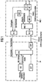
- the arrangement comprises a mobile radio terminal MG 1, here a conventional mobile keyboard and a microphone as input device EE 1, here a display and a speaker as output device AE 1 and integrated in the device as a software route control device RKE 1 and an integrated GPS receiver as location determining means SBE 1 contains.
- the mobile radio terminal MG 1 has a transmitter TX 1 and a receiver RX 1, for exchanging radio signals with base stations of a (not shown) mobile radio network.
- the input device EE 1 is connected to the transmitter TX 1, so that data from the input device EE can be transmitted to the transmitter TX 1.
- the Location determining means SBE 1 is connected to the transmitter TX 1 and to the route control means RKE 1 to transmit location data thereto.
- the route control device RKE 1 is connected on the input side to the receiver RX 1 and on the output side via a media transfer function SRF1 to the output device AE 1.
- the arrangement also has a communication network, which is designed as an intelligent network IN.
- the connection between the mobile radio network and the intelligent network IN is made by a service switching node (SSP), which forms the interface between the two networks.
- SSP service switching node
- the IN hardware consists of digital exchanges (service switching nodes) and corresponding service control nodes (SCP).
- SCP service control nodes
- the service switching node recognizes the actual call of a smart service and forwards the information to the corresponding service control node.
- the service control node which is formed by one or more computer systems, contains a route planning device RPE, which receives data inputs via the service switching node, as well as a complex navigation database ND.
- the route planning device RPE is in turn connected to the navigation database ND and transmits query data to the navigation database ND and reads data retrieved from the navigation database ND.
- the navigation database is dynamically linked to other databases (yellow pages data base, traffic data base, railway traffic database, air traffic data base, local traffic database) to create the shortest connection and to propose a change of transport due to the current traffic situation.
- the route planning device is also connected to a timer TIME.
- the route planning device calculates the expected travel time. The forecast of the route time of the individual route sections depends on the current time, especially in the use of public transport and in rush hour.
- the route planning device is also connected to the mobile radio network by the service control node SSP in order to forward the determined information.
- this embodiment represents a less expensive solution since the intelligence is completely provided in the intelligent network IN, on the other hand the network load is increased by continuously transmitted route guidance information.
Landscapes
- Engineering & Computer Science (AREA)
- Radar, Positioning & Navigation (AREA)
- Remote Sensing (AREA)
- Physics & Mathematics (AREA)
- General Physics & Mathematics (AREA)
- Mathematical Physics (AREA)
- Navigation (AREA)
- Mobile Radio Communication Systems (AREA)
- Traffic Control Systems (AREA)
Claims (17)
- Dispositif de guidage vers une destination en utilisant un réseau de communication, comportant- un dispositif d'accès (MG1 ; MG2) au réseau de communication, lequel dispositif d'accès contient un dispositif d'entrée (EE1 ; EE2) pour l'entrée de la destination,- un dispositif de traitement qui est prévu dans le réseau de communication ou qui est central et relié à celui-ci et auquel sont raccordés une base dé données de navigation (ND) avec des données de navigation pour le guidage ainsi qu'un dispositif de planification d'itinéraire (RPE) destiné à déterminer une information de guidage globale,- un dispositif de localisation (SBE1 ; SBE2) pour la détermination des données de position d'un utilisateur,- un dispositif de contrôle d'itinéraire (RKE1 ; RKE2) qui est relié au dispositif de planification d'itinéraire (RPE) et au dispositif de localisation (SBE1 ; SBE2) par l'intermédiaire du réseau de communication et qui est destiné à l'évaluation périodique ou continue des signaux du dispositif de localisation (SBE1 ; SBE2) et à la comparaison des données de position actuelles de l'utilisateur à l'information de guidage globale- ainsi qu'un dispositif de sortie (AE1 ; AE2) qui est relié au dispositif de contrôle d'itinéraire (RKE1 ; RKE2) par l'intermédiaire d'une fonction de transmission (SRF1 ; SRF2) en vue de la sortie de l'information de guidage locale déduite de l'information de guidage globale et des données de position, la fonction de transmission transmettant cette information sous forme de paroles, textes, graphiques ou données préalablement enregistrés ou synthétisés.
- Dispositif selon la revendication 1,
caractérisé par le fait que la base de données de navigation (ND) contient des données dynamiquement variables qui sont actualisées et complétées par l'intermédiaire d'une liaison permanente ou périodiquement établie vers d'autres bases de données, notamment une base de données d'adresses, une base de données de contrôle de trafic ou de situations de trafic, une base de données de trafic ferroviaire ou une base de données de trafic de grande banlieue. - Dispositif selon la revendication 1 ou 2,
caractérisé par le fait que la base de données de navigation (ND) comporte des matrices de liaison dont les valeurs dépendent de la situation actuelle du trafic et/ou du jour et de l'heure. - Dispositif selon l'une des revendications précédentes,
caractérisé par le fait que le dispositif d'accès au réseau de communication comprend un terminal de radiocommunication mobile et les interfaces, formées par l'intermédiaire d'un système de stations de base, de l'infrastructure fixe du réseau de communication. - Dispositif selon la revendication 4,
caractérisé par le fait que le dispositif de contrôle d'itinéraire (RKE1 ; RKE2) est mis en oeuvre sous forme de matériel et/ou de logiciel dans le terminal de radiocommunication mobile. - Dispositif selon l'une des revendications précédentes,
caractérisé par le fait que le dispositif de contrôle d'itinéraire (RKE1 ; RKE2) est prévu dans le réseau de communication (KN). - Dispositif selon l'une des revendications précédentes,
caractérisé par le fait que le dispositif de localisation (SBE1 ; SBE2) comporte un récepteur GPS, qui est prévu dans le terminal de radiocommunication mobile ou avec celui-ci, et un compas à champ terrestre basé sur une puce. - Dispositif selon l'une des revendications précédentes,
caractérisé par le fait que le dispositif de planification d'itinéraire (RPE) et le dispositif de contrôle d'itinéraire (RKE) coopèrent en cascade. - Dispositif selon l'une des revendications précédentes,
caractérisé par le fait que des moyens sont prévus pour la sélection de profils d'utilisateurs spéciaux. - Dispositif selon l'une des revendications précédentes,
caractérisé par le fait que des moyens sont prévus pour la sélection de différents modes de progression par l'utilisateur. - Dispositif selon l'une des revendications précédentes,
caractérisé par le fait que des moyens sont prévus pour la sélection d'un critère d'optimisation pour l'information de guidage globale. - Dispositif selon l'une des revendications précédentes,
caractérisé par le fait que des moyens sont prévus pour la sélection de différents formats de sortie pour l'information de guidage transmise par l'utilisateur. - Dispositif selon l'une des revendications 1 à 6 ou 8 à 12,
caractérisé par le fait que le dispositif de localisation (SBE1 ; SBE2), réalisé notamment par l'intermédiaire du système de stations de base, est prévu dans l'infrastructure fixe du réseau de communication. - Procédé pour le guidage vers une destination en utilisant un réseau de communication, avec les étapes suivantes :- entrée de destination par l'intermédiaire d'un dispositif d'accès (MG1 ; MG2) à un dispositif de traitement qui est prévu dans le réseau de communication ou qui est central et relié à celui-ci,- détermination des données de position d'un utilisateur par l'intermédiaire d'un dispositif de localisation (SBE1 ; SBE2),- transmission des données de position de l'utilisateur et de l'entrée de destination par l'intermédiaire du réseau de communication à un dispositif de planification d'itinéraire (RPE),- lecture d'informations de guidage dans une base de données de navigation (ND), en fonction de l'information d'entrée de destination et des données de position de l'utilisateur,- détermination d'une information de guidage globale dans le dispositif de planification d'itinéraire (RPE),- transmission de l'information de guidage globale et des données de position actuelles de l'utilisateur à un dispositif de contrôle d'itinéraire (RKE1 ; RKE2),- comparaison périodique ou continue de l'information de guidage globale et des données de position actuelles par l'intermédiaire du dispositif de contrôle d'itinéraire (RKE1 ; RKE2) en vue de l'obtention d'une information de guidage locale,- transmission de l'information de guidage locale à l'utilisateur par un dispositif de sortie (AE1 ; AE2) qui est relié par l'intermédiaire d'une fonction de transmission (SRF1 ; SRF2) au dispositif de contrôle d'itinéraire (RKE1 ; RKE2), la fonction de transmission transmettant les informations de guidage sous forme de paroles, textes, graphiques ou données préalablement enregistrés ou synthétisés.
- Procédé selon la revendication 14,
caractérisé par le fait que l'on enregistre en continu ou périodiquement les données de navigation au moyen d'une liaison permanente ou périodiquement établie de la base de données de navigation (ND) vers d'autres bases de données, notamment une base de données d'annuaire par métiers, une base de données de radios autoroutières, une base de données de trafic ferroviaire ou une base de données de trafic de grande banlieue. - Procédé selon la revendication 14 ou 15,
caractérisé par le fait que, en utilisant les structures de facturation du réseau intelligent, on effectue une facturation de l'information de guidage globale déterminée et de l'information de guidage locale déterminée. - Procédé selon l'une des revendications 14 à 16,
caractérisé par le fait que l'information de guidage globale comprend une recommandation d'itinéraire intermodal et une prise en compte de la situation actuelle du trafic.
Applications Claiming Priority (2)
| Application Number | Priority Date | Filing Date | Title |
|---|---|---|---|
| DE19946162 | 1999-09-27 | ||
| DE19946162A DE19946162A1 (de) | 1999-09-27 | 1999-09-27 | Anordnung und Verfahren zur Zielführung unter Nutzung eines Kommunikationsnetzes, insbesondere eines Mobilfunknetzes |
Publications (2)
| Publication Number | Publication Date |
|---|---|
| EP1087357A1 EP1087357A1 (fr) | 2001-03-28 |
| EP1087357B1 true EP1087357B1 (fr) | 2006-11-02 |
Family
ID=7923393
Family Applications (1)
| Application Number | Title | Priority Date | Filing Date |
|---|---|---|---|
| EP00119946A Expired - Lifetime EP1087357B1 (fr) | 1999-09-27 | 2000-09-13 | Dispositif et procédé pour navigation par l'intermédiaire d'un réseau de télécommunications |
Country Status (3)
| Country | Link |
|---|---|
| US (1) | US6529736B1 (fr) |
| EP (1) | EP1087357B1 (fr) |
| DE (2) | DE19946162A1 (fr) |
Families Citing this family (10)
| Publication number | Priority date | Publication date | Assignee | Title |
|---|---|---|---|---|
| AU2001276617A1 (en) * | 2000-08-23 | 2002-03-04 | Nokia Corporation | Travel-tracking and real-time routing information system |
| US6922629B2 (en) * | 2001-08-10 | 2005-07-26 | Aisin Aw Co., Ltd. | Traffic information retrieval method, traffic information retrieval system, mobile communication device, and network navigation center |
| US7885409B2 (en) | 2002-08-28 | 2011-02-08 | Rockwell Collins, Inc. | Software radio system and method |
| DE10242043A1 (de) * | 2002-09-11 | 2004-04-01 | T-Mobile Traffic Gmbh | Ortungsvorrichtung |
| US20060235856A1 (en) * | 2004-12-16 | 2006-10-19 | Halcrow Michael A | Route generation for task completion by a location-aware device |
| US7720506B1 (en) | 2006-07-28 | 2010-05-18 | Rockwell Collins, Inc. | System and method of providing antenna specific front ends for aviation software defined radios |
| US7831255B1 (en) | 2006-07-31 | 2010-11-09 | Rockwell Collins, Inc. | System and method of providing automated availability and integrity verification for aviation software defined radios |
| WO2008087655A2 (fr) * | 2007-01-18 | 2008-07-24 | Nitin Invofin Trade Private Limited | Sous-réseau gsm fondé sur la commutation distribuée et des noeuds d'accès à connectivité de liaison terrestre optimisée |
| EP2825848A4 (fr) * | 2012-03-16 | 2016-01-06 | Qoros Automotive Co Ltd | Mises à jour partielles de carte |
| WO2016018936A1 (fr) | 2014-07-28 | 2016-02-04 | Econolite Group, Inc. | Contrôleur de signal de trafic auto-configurable |
Family Cites Families (8)
| Publication number | Priority date | Publication date | Assignee | Title |
|---|---|---|---|---|
| DE4214067C2 (de) | 1992-04-29 | 1995-08-31 | Heinrich Wanko | Verfahren zur Überwachung des Transports von Gütern zu vorbestimmten Abnahmestellen |
| JP3385657B2 (ja) * | 1993-08-10 | 2003-03-10 | トヨタ自動車株式会社 | 車載用ナビゲーション装置 |
| DE19519066A1 (de) | 1994-11-28 | 1996-05-30 | Mannesmann Ag | Verfahren und System zur Zielführung eines Fahrzeugs |
| GB2298539A (en) * | 1995-02-27 | 1996-09-04 | Richard Deehan | Portable guidance device |
| US5933100A (en) * | 1995-12-27 | 1999-08-03 | Mitsubishi Electric Information Technology Center America, Inc. | Automobile navigation system with dynamic traffic data |
| DE19625002B4 (de) | 1996-06-22 | 2005-03-10 | Daimler Chrysler Ag | Fahrzeugkommunikationssystem |
| DE19651143B4 (de) * | 1996-12-10 | 2013-07-25 | T-Mobile Deutschland Gmbh | Verfahren und Anordnung zur Verkehrsinformation |
| DE19824587A1 (de) * | 1998-06-02 | 1998-12-03 | Markus Huber | Kommunizierendes Navigationssystem |
-
1999
- 1999-09-27 DE DE19946162A patent/DE19946162A1/de not_active Withdrawn
-
2000
- 2000-09-13 DE DE50013681T patent/DE50013681D1/de not_active Expired - Lifetime
- 2000-09-13 EP EP00119946A patent/EP1087357B1/fr not_active Expired - Lifetime
- 2000-09-27 US US09/671,824 patent/US6529736B1/en not_active Expired - Lifetime
Also Published As
| Publication number | Publication date |
|---|---|
| EP1087357A1 (fr) | 2001-03-28 |
| DE50013681D1 (de) | 2006-12-14 |
| DE19946162A1 (de) | 2001-04-05 |
| US6529736B1 (en) | 2003-03-04 |
Similar Documents
| Publication | Publication Date | Title |
|---|---|---|
| DE69506563T3 (de) | Navigationsinformationssytem | |
| DE60124391T2 (de) | Navigationssystem | |
| DE60132340T2 (de) | Verfahren und system zur bereitstellung von verkehrs- und verkehrsbezogenen informationen | |
| DE69916482T2 (de) | Fahrerinformationssystem | |
| DE69819337T2 (de) | Fahrzeuginformationssystem | |
| DE69427327T2 (de) | Bordnavigationsanlage für Fahrzeuge | |
| DE10217880B4 (de) | Verfahren zum Kompilieren von Navigationsrouteninhalt | |
| DE69720188T2 (de) | Routenauswahlsystem für wandernde personen | |
| EP1538582A2 (fr) | Procédé d'émission d'information routière dans un véhicule | |
| DE3887285T2 (de) | Zielführungs- und Streckenauswahlsysteme für Kraftfahrzeuge. | |
| DE19623666C1 (de) | Verfahren zur dynamischen Routenempfehlung | |
| WO2001002806A1 (fr) | Procede et dispositif pour la transmission d'informations de navigation d'une centrale de donnees a un systeme de navigation monte dans un vehicule | |
| WO2005029376A1 (fr) | Systeme pour la fourniture de services | |
| EP0939945B1 (fr) | Procede de selection et de filtrage d'informations sur la circulation routiere | |
| DE60036471T2 (de) | Mobiles Navigationssystem | |
| WO2008012175A1 (fr) | Procédé pour déterminer un point de rencontre commun pour au moins deux systèmes de navigation | |
| EP1087357B1 (fr) | Dispositif et procédé pour navigation par l'intermédiaire d'un réseau de télécommunications | |
| DE10021171A1 (de) | Navigationsverfahren und -vorrichtung | |
| DE19803659A1 (de) | Navigationsverfahren, insbesondere für Fahrzeuge | |
| EP1092951A2 (fr) | Système de navigation à fonction d'affichage étendue | |
| EP0925565B1 (fr) | Systeme de gestion du trafic de transport et du trafic touristique | |
| DE102007032956B4 (de) | Fahrzeugnavigationssystem im Netzwerkverbund mit Navigationssystemen anderer Fahrzeuge mit Filterung des Dateneingangs sowie zur Ermittlung von Verkehrsstörungen | |
| Xu | Development of transport telematics in Europe | |
| DE10110549B4 (de) | Verkehrsinformationssystem für Fahrzeuge auf einem Verkehrswegenetz | |
| DE10233378A1 (de) | Intelligentes vorrausschauendes Navigationssystem bzw. Verkehrswarnsystem |
Legal Events
| Date | Code | Title | Description |
|---|---|---|---|
| PUAI | Public reference made under article 153(3) epc to a published international application that has entered the european phase |
Free format text: ORIGINAL CODE: 0009012 |
|
| AK | Designated contracting states |
Kind code of ref document: A1 Designated state(s): AT BE CH CY DE DK ES FI FR GB GR IE IT LI LU MC NL PT SE |
|
| AX | Request for extension of the european patent |
Free format text: AL;LT;LV;MK;RO;SI |
|
| 17P | Request for examination filed |
Effective date: 20010219 |
|
| AKX | Designation fees paid |
Free format text: DE FI FR GB |
|
| GRAP | Despatch of communication of intention to grant a patent |
Free format text: ORIGINAL CODE: EPIDOSNIGR1 |
|
| GRAS | Grant fee paid |
Free format text: ORIGINAL CODE: EPIDOSNIGR3 |
|
| GRAA | (expected) grant |
Free format text: ORIGINAL CODE: 0009210 |
|
| AK | Designated contracting states |
Kind code of ref document: B1 Designated state(s): DE FI FR GB |
|
| PG25 | Lapsed in a contracting state [announced via postgrant information from national office to epo] |
Ref country code: FI Free format text: LAPSE BECAUSE OF FAILURE TO SUBMIT A TRANSLATION OF THE DESCRIPTION OR TO PAY THE FEE WITHIN THE PRESCRIBED TIME-LIMIT Effective date: 20061102 |
|
| REG | Reference to a national code |
Ref country code: GB Ref legal event code: FG4D Free format text: NOT ENGLISH |
|
| REF | Corresponds to: |
Ref document number: 50013681 Country of ref document: DE Date of ref document: 20061214 Kind code of ref document: P |
|
| GBT | Gb: translation of ep patent filed (gb section 77(6)(a)/1977) |
Effective date: 20070205 |
|
| ET | Fr: translation filed | ||
| PLBE | No opposition filed within time limit |
Free format text: ORIGINAL CODE: 0009261 |
|
| STAA | Information on the status of an ep patent application or granted ep patent |
Free format text: STATUS: NO OPPOSITION FILED WITHIN TIME LIMIT |
|
| 26N | No opposition filed |
Effective date: 20070803 |
|
| REG | Reference to a national code |
Ref country code: FR Ref legal event code: PLFP Year of fee payment: 17 |
|
| REG | Reference to a national code |
Ref country code: FR Ref legal event code: PLFP Year of fee payment: 18 |
|
| REG | Reference to a national code |
Ref country code: FR Ref legal event code: PLFP Year of fee payment: 19 |
|
| REG | Reference to a national code |
Ref country code: DE Ref legal event code: R081 Ref document number: 50013681 Country of ref document: DE Owner name: LOUGH CORRIB INTELLECTUAL PROPERTY LTD., IE Free format text: FORMER OWNER: SIEMENS AKTIENGESELLSCHAFT, 80333 MUENCHEN, DE |
|
| REG | Reference to a national code |
Ref country code: GB Ref legal event code: 732E Free format text: REGISTERED BETWEEN 20190808 AND 20190814 |
|
| PGFP | Annual fee paid to national office [announced via postgrant information from national office to epo] |
Ref country code: DE Payment date: 20190807 Year of fee payment: 20 Ref country code: FR Payment date: 20190809 Year of fee payment: 20 |
|
| PGFP | Annual fee paid to national office [announced via postgrant information from national office to epo] |
Ref country code: GB Payment date: 20190813 Year of fee payment: 20 |
|
| REG | Reference to a national code |
Ref country code: DE Ref legal event code: R071 Ref document number: 50013681 Country of ref document: DE |
|
| REG | Reference to a national code |
Ref country code: GB Ref legal event code: PE20 Expiry date: 20200912 |
|
| PG25 | Lapsed in a contracting state [announced via postgrant information from national office to epo] |
Ref country code: GB Free format text: LAPSE BECAUSE OF EXPIRATION OF PROTECTION Effective date: 20200912 |
|
| REG | Reference to a national code |
Ref country code: GB Ref legal event code: 732E Free format text: REGISTERED BETWEEN 20201105 AND 20201111 |
|
| REG | Reference to a national code |
Ref country code: GB Ref legal event code: 732E Free format text: REGISTERED BETWEEN 20201203 AND 20201209 |
|
| REG | Reference to a national code |
Ref country code: GB Ref legal event code: 732E Free format text: REGISTERED BETWEEN 20210107 AND 20210113 |