EP1092952A1 - Système de navigation avec changeur de porteur de données automatique - Google Patents
Système de navigation avec changeur de porteur de données automatique Download PDFInfo
- Publication number
- EP1092952A1 EP1092952A1 EP00120431A EP00120431A EP1092952A1 EP 1092952 A1 EP1092952 A1 EP 1092952A1 EP 00120431 A EP00120431 A EP 00120431A EP 00120431 A EP00120431 A EP 00120431A EP 1092952 A1 EP1092952 A1 EP 1092952A1
- Authority
- EP
- European Patent Office
- Prior art keywords
- navigation system
- data
- computing unit
- route
- vehicle position
- Prior art date
- Legal status (The legal status is an assumption and is not a legal conclusion. Google has not performed a legal analysis and makes no representation as to the accuracy of the status listed.)
- Withdrawn
Links
Images

Classifications
-
- G—PHYSICS
- G01—MEASURING; TESTING
- G01C—MEASURING DISTANCES, LEVELS OR BEARINGS; SURVEYING; NAVIGATION; GYROSCOPIC INSTRUMENTS; PHOTOGRAMMETRY OR VIDEOGRAMMETRY
- G01C21/00—Navigation; Navigational instruments not provided for in groups G01C1/00 - G01C19/00
- G01C21/26—Navigation; Navigational instruments not provided for in groups G01C1/00 - G01C19/00 specially adapted for navigation in a road network
- G01C21/34—Route searching; Route guidance
- G01C21/3446—Details of route searching algorithms, e.g. Dijkstra, A*, arc-flags or using precalculated routes
-
- G—PHYSICS
- G01—MEASURING; TESTING
- G01C—MEASURING DISTANCES, LEVELS OR BEARINGS; SURVEYING; NAVIGATION; GYROSCOPIC INSTRUMENTS; PHOTOGRAMMETRY OR VIDEOGRAMMETRY
- G01C21/00—Navigation; Navigational instruments not provided for in groups G01C1/00 - G01C19/00
- G01C21/38—Electronic maps specially adapted for navigation; Updating thereof
Definitions
- the invention relates to a navigation system of a motor vehicle with a Computing unit for calculating a route between a start and a destination, a reader connected to the computing unit for Reading map data from a data carrier, means for determination the vehicle position, one connected to the computing unit Input unit and an output unit connected to the computing unit.
- map data required for route calculation are stored on an exchangeable data carrier, which is in usually a CD-ROM.
- the ones stored on the CD-ROM Map data cover a certain geographic area which is mostly limited by the borders of a country. When driving beyond the national borders, must therefore when crossing the national border the CD-ROM is changed and the country's CD-ROM, into which the motor vehicle is currently driving. In addition the driver must then enter the new destination so that the Route calculation can be done. This is often referred to as viewed unsatisfactorily.
- the object of the invention is therefore to provide a navigation system, which ensures simplified operation, even when leaving the geographical area, the map data of which is currently inserted CD-ROM are saved.
- the object is achieved in that the reader for recording several exchangeable data carriers as well as for optional reading of data from one of the data carriers and the navigation system Means for selecting a data carrier depending on the vehicle position contains.
- the navigation system according to the invention has thus first a reader in which several data carriers are inserted can be.
- the reader is thus designed as a CD changer.
- Navigation system according to the invention Means for selecting a data carrier depending on the vehicle position.
- the vehicle position is continuously determined in navigation systems to provide the required route guidance information to be able to spend at the right time.
- the Vehicle position can therefore also be used to query whether the geographic location corresponding to the vehicle position on one of the existing and possibly on which CD-ROM is available.
- the CD-ROM can be selected automatically that the contains geographical data of the current position.
- the navigation system designed for route calculation via at least 2 databases which are stored on different data carriers.
- the driver only has to enter the start and the destination and the Route planning takes place with the automatic selection of a stopover.
- a reader that can hold several data carriers can possibly for reasons of space, not in the immediate vicinity of the computing unit to be ordered. Therefore, when connecting the computing unit with to bridge the reader in the motor vehicle sometimes longer distances by cable. In a special embodiment it is therefore provided that that the connection between the reader and the computing unit is wireless, in particular via a radio interface.
- the route guidance information can be output via an acoustic signal as well as an optical output unit.
- the input For example, the destination can be done using a keyboard. Particularly preferred however, if necessary additionally, becomes a voice input unit, because here an entry can still be made while driving.
- the navigation system with a device for receiving Traffic information is connected or contains and the Traffic information is taken into account when guiding the route.
- it can be a device for receiving traffic information act as a car radio with RDS / TMC receiver, so that the Broadcast stations in the background of the current program Receive traffic information and go straight to further processing can be forwarded to the navigation system.
- Traffic information is also provided by mobile operators provided by the mobile device to the Navigation system to be forwarded for further processing.
- a wireless connection between the Mobile device and the navigation device preferred.
- it is a short-range radio connection using the Bluetooth method act.
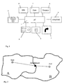
- the route guidance information can still be heard through a loudspeaker 4 be output acoustically.
- the computing unit 1 is also connected to a reader 5, in the data carrier with map data can be inserted.
- Reader 5 around a CD changer in which several CD-ROMs are inserted can map data to different geographic locations Areas included.
- the reading device 5 is operated by the computing unit 1 controlled directly. Using the map data, the computing unit 1 with known starting and destination in a known manner the optimal route can be carried out, which then over the optical output unit 3 can be output.
- the navigation system contains also a receiver 6 for receiving satellite navigation signals.
- the navigation system also contains a direction sensor 7 and a displacement sensor 8, which also with the Computing unit 1 are connected.
- a suitable one Computer program using these signals a position determination possible.
- the computer program running in the computing unit 1 is now designed so that depending on the currently determined Vehicle position is checked, which of those inserted in drive 5 Data carrier contains the current geographical vehicle position.
- the disk that contains the current vehicle position will selected and based on the map data stored on it performed a route calculation. Furthermore, on the route calculation based route guidance information output.
- the computing unit 1 additionally connected to a radio receiver 9 for reception of RDS / TMC signals.
- a radio receiver 9 for reception of RDS / TMC signals.
- Reaching of the stopover is determined by the navigation system based on the permanent position determination automatically recognized. Becomes the stopover reached, a query is automatically carried out on which CD-ROM the current vehicle position, which is now in country B is present.
- the corresponding CD-ROM is now selected and can be used for route calculation and route guidance without the user having to intervene. To one To ensure seamless route guidance, it is within the scope of the invention also possible, the CD-ROM shortly before reaching the intermediate goal to switch and carry out the further route calculation.
- the remaining route guidance information for the remaining one Travel in country A are stored in a memory.
- FIG. 3 shows a simple process sequence from which the selection can be made the required CD-ROM can be seen.
- step S1 first determines the vehicle position. This will also follow continuously determined in parallel with the other procedural steps.
- step S2 becomes the starting point and the destination as well as the stopover at which a Crossing the border should be entered. Instead of entering the starting location can also automatically use the current vehicle position as the starting point if available.
- step S3 the selection of the CD-ROM, which shows the current vehicle position, and therefore the starting location.
- a route planning is then carried out in step S4 between the starting point and the stopover.
- Step S5 then outputs the route guidance information. This continues until the intermediate goal is reached. Reaching the intermediate goal is achieved through constant evaluation of the current one Vehicle position detected.
- step S7 the CD-ROM changed (step S7) and now the CD-ROM selected that contains the current location of the vehicle. Based The map data on this CD-ROM is now used for route planning between the stopover and the destination (S8), so that subsequently the corresponding route guidance information again in step S9 can be spent.
Landscapes
- Engineering & Computer Science (AREA)
- Radar, Positioning & Navigation (AREA)
- Remote Sensing (AREA)
- Automation & Control Theory (AREA)
- Physics & Mathematics (AREA)
- General Physics & Mathematics (AREA)
- Navigation (AREA)
Applications Claiming Priority (2)
| Application Number | Priority Date | Filing Date | Title |
|---|---|---|---|
| DE19947790A DE19947790A1 (de) | 1999-10-05 | 1999-10-05 | Navigationssystem mit automatischem Datenträgerwechsel |
| DE19947790 | 1999-10-05 |
Publications (1)
| Publication Number | Publication Date |
|---|---|
| EP1092952A1 true EP1092952A1 (fr) | 2001-04-18 |
Family
ID=7924466
Family Applications (1)
| Application Number | Title | Priority Date | Filing Date |
|---|---|---|---|
| EP00120431A Withdrawn EP1092952A1 (fr) | 1999-10-05 | 2000-09-19 | Système de navigation avec changeur de porteur de données automatique |
Country Status (3)
| Country | Link |
|---|---|
| US (1) | US6438489B1 (fr) |
| EP (1) | EP1092952A1 (fr) |
| DE (1) | DE19947790A1 (fr) |
Cited By (2)
| Publication number | Priority date | Publication date | Assignee | Title |
|---|---|---|---|---|
| WO2004048894A1 (fr) * | 2002-11-27 | 2004-06-10 | Robert Bosch Gmbh | Systeme de navigation et procede de fonctionnement d'un systeme de navigation |
| RU2308681C1 (ru) * | 2006-03-22 | 2007-10-20 | Открытое акционерное общество "Специальное конструкторское бюро приборостроения и автоматики" | Гироскопическая навигационная система для подвижных объектов |
Families Citing this family (9)
| Publication number | Priority date | Publication date | Assignee | Title |
|---|---|---|---|---|
| US6934630B2 (en) * | 2000-12-20 | 2005-08-23 | The John Hopkins University | GPS receiver tracking system |
| US20050107929A1 (en) * | 2001-09-01 | 2005-05-19 | Bayerische Motoren Werke Ag | Method, device and computer product for updating data of a control device |
| DE10155514A1 (de) | 2001-11-13 | 2003-08-21 | Bosch Gmbh Robert | Verfahren zur Navigation eines Fahrzeugs |
| DE10162359B4 (de) * | 2001-12-18 | 2012-10-31 | Robert Bosch Gmbh | Verfahren zur Bereitstellung von Routendaten für ein Navigationsgerät |
| DE10261028A1 (de) * | 2002-12-24 | 2004-07-08 | Robert Bosch Gmbh | Verfahren zur Übermittlung ortsbezogener Informationen |
| JP5012504B2 (ja) * | 2005-03-30 | 2012-08-29 | アイシン・エィ・ダブリュ株式会社 | 車両用ナビゲーションシステム |
| TWI379994B (en) * | 2008-03-28 | 2012-12-21 | Pegatron Corp | Navigation device and navigation information processing method thereof |
| DE102010030419B4 (de) * | 2010-06-23 | 2017-11-30 | Bayerische Motoren Werke Aktiengesellschaft | Navigationssystem |
| US10139243B2 (en) * | 2016-04-30 | 2018-11-27 | Toyota Motor Engineering & Manufacturing North America, Inc. | High level instruction for navigational routing systems |
Citations (4)
| Publication number | Priority date | Publication date | Assignee | Title |
|---|---|---|---|---|
| JPH037983A (ja) * | 1989-06-05 | 1991-01-16 | Alpine Electron Inc | 地図用記憶媒体の交換方法 |
| JPH0546090A (ja) * | 1991-08-15 | 1993-02-26 | Sony Corp | 情報検索システムおよびナビゲーシヨンシステム |
| EP0798539A2 (fr) * | 1996-03-29 | 1997-10-01 | Sanyo Electric Co. Ltd | Dispositif de navigation |
| US5790975A (en) * | 1989-12-13 | 1998-08-04 | Pioneer Electronic Corporation | Onboard navigational system |
Family Cites Families (11)
| Publication number | Priority date | Publication date | Assignee | Title |
|---|---|---|---|---|
| DE3904344A1 (de) * | 1989-02-14 | 1990-08-16 | Bosch Gmbh Robert | Verfahren zum lesen von navigationsdaten einer compact-disc |
| DE3910194A1 (de) * | 1989-03-23 | 1990-09-27 | Heinrich Strucken | Leitsystem zur fuehrung von verkehrsteilnehmern |
| US5515284A (en) * | 1991-09-25 | 1996-05-07 | Zexel Corporation | Storage medium for map information for navigation system and system for offering map information for navigation system |
| JP3518555B2 (ja) * | 1993-08-03 | 2004-04-12 | ソニー株式会社 | 送信装置及び送信方法並びに送受信装置 |
| DE4429121C1 (de) * | 1994-08-17 | 1996-02-22 | Siemens Ag | Navigationssystem für ein Fahrzeug |
| JP3329617B2 (ja) | 1995-04-12 | 2002-09-30 | 松下電器産業株式会社 | ナビゲーション装置 |
| JP2907079B2 (ja) * | 1995-10-16 | 1999-06-21 | ソニー株式会社 | ナビゲーション装置,ナビゲート方法及び自動車 |
| KR970002795A (ko) * | 1995-10-30 | 1997-01-28 | 모리 하루오 | 네비게이션(navigation)장치 |
| JP4121157B2 (ja) * | 1997-07-01 | 2008-07-23 | マネスマン ファウデーオー アーゲー | 車両用ナビゲーションシステム |
| JP4009789B2 (ja) * | 1997-10-09 | 2007-11-21 | ソニー株式会社 | 送信機 |
| US6240347B1 (en) * | 1998-10-13 | 2001-05-29 | Ford Global Technologies, Inc. | Vehicle accessory control with integrated voice and manual activation |
-
1999
- 1999-10-05 DE DE19947790A patent/DE19947790A1/de not_active Withdrawn
-
2000
- 2000-09-19 EP EP00120431A patent/EP1092952A1/fr not_active Withdrawn
- 2000-10-04 US US09/678,135 patent/US6438489B1/en not_active Expired - Fee Related
Patent Citations (4)
| Publication number | Priority date | Publication date | Assignee | Title |
|---|---|---|---|---|
| JPH037983A (ja) * | 1989-06-05 | 1991-01-16 | Alpine Electron Inc | 地図用記憶媒体の交換方法 |
| US5790975A (en) * | 1989-12-13 | 1998-08-04 | Pioneer Electronic Corporation | Onboard navigational system |
| JPH0546090A (ja) * | 1991-08-15 | 1993-02-26 | Sony Corp | 情報検索システムおよびナビゲーシヨンシステム |
| EP0798539A2 (fr) * | 1996-03-29 | 1997-10-01 | Sanyo Electric Co. Ltd | Dispositif de navigation |
Non-Patent Citations (2)
| Title |
|---|
| PATENT ABSTRACTS OF JAPAN vol. 015, no. 119 (P - 1183) 22 March 1991 (1991-03-22) * |
| PATENT ABSTRACTS OF JAPAN vol. 017, no. 341 (P - 1565) 28 June 1993 (1993-06-28) * |
Cited By (4)
| Publication number | Priority date | Publication date | Assignee | Title |
|---|---|---|---|---|
| WO2004048894A1 (fr) * | 2002-11-27 | 2004-06-10 | Robert Bosch Gmbh | Systeme de navigation et procede de fonctionnement d'un systeme de navigation |
| US7593813B2 (en) | 2002-11-27 | 2009-09-22 | Robert Bosch Gmbh | Navigation system and method for operating a navigation system |
| CN100573051C (zh) * | 2002-11-27 | 2009-12-23 | 罗伯特-博希股份公司 | 导航系统和运行导航系统的方法 |
| RU2308681C1 (ru) * | 2006-03-22 | 2007-10-20 | Открытое акционерное общество "Специальное конструкторское бюро приборостроения и автоматики" | Гироскопическая навигационная система для подвижных объектов |
Also Published As
| Publication number | Publication date |
|---|---|
| DE19947790A1 (de) | 2001-04-12 |
| US6438489B1 (en) | 2002-08-20 |
Similar Documents
| Publication | Publication Date | Title |
|---|---|---|
| DE69531248T2 (de) | Intelligentes zielführungssystem für fahrzeuge | |
| DE69413322T2 (de) | Navigationssystem | |
| EP1030166B1 (fr) | Méthode pour la navigation d' un objet | |
| DE4219171C2 (de) | Vorrichtung zur bildlichen Wiedergabe von Karten | |
| DE69430029T2 (de) | Navigationsanlage | |
| EP1147375B1 (fr) | Procede pour guider le pilote d'un vehicule entre au moins un point de depart et au moins un point de destination | |
| DE69333916T2 (de) | Navigationsgerät für Fahrzeuge zur Bestimmung eines neuen Leitwegs, wenn ein Fahrzeug von seinem Leitweg abweicht | |
| DE69624887T2 (de) | Fahrzeugnavigationssystem | |
| EP1269119B1 (fr) | Procede pour entrer une destination dans un appareil de navigation | |
| DE69819337T2 (de) | Fahrzeuginformationssystem | |
| DE60010080T2 (de) | Tragbares informationsgerät für fahrer | |
| DE19912859A1 (de) | Kommunikationsfähiges Navigationssystem | |
| DE19808802A1 (de) | Kraftfahrzeugnavigationssystem | |
| DE60306021T2 (de) | Navigationsvorrichtung, -verfahren sowie -programm zur Aktualisierung von Einrichtungsinformationen und Aufzeichnungsträger zum Speichern des Programms | |
| DE19716354A1 (de) | Navigationssystem für Fahrzeuge | |
| WO2001002806A1 (fr) | Procede et dispositif pour la transmission d'informations de navigation d'une centrale de donnees a un systeme de navigation monte dans un vehicule | |
| DE10053874B4 (de) | Verfahren zur Navigation und Vorrichtung zu dessen Durchführung | |
| DE19836151A1 (de) | Fahrzeugnavigationssystem und Speichermedium | |
| EP1133675B1 (fr) | Dispositif et procede de navigation | |
| DE19947790A1 (de) | Navigationssystem mit automatischem Datenträgerwechsel | |
| EP1065472B1 (fr) | Dispositif d'information, élément d'un système de navigation | |
| EP1039429B1 (fr) | Méthode de guidage portable de route avec un appareil de navigation embarqué ainsi que système de navigation portable | |
| DE19701370A1 (de) | Verfahren zur Erweiterung von abgespeicherten Datensätzen eines Straßennetzes | |
| DE69726512T2 (de) | Fahrzeugsnavigationssystem mit Beschleunigung von Stadtnamenselektion und Programmspeichermedium | |
| DE10041376B4 (de) | Navigationssystem und Speicherträger, in dem Programme gespeichert sind |
Legal Events
| Date | Code | Title | Description |
|---|---|---|---|
| PUAI | Public reference made under article 153(3) epc to a published international application that has entered the european phase |
Free format text: ORIGINAL CODE: 0009012 |
|
| AK | Designated contracting states |
Kind code of ref document: A1 Designated state(s): DE FR GB |
|
| AX | Request for extension of the european patent |
Free format text: AL;LT;LV;MK;RO;SI |
|
| 17P | Request for examination filed |
Effective date: 20010906 |
|
| AKX | Designation fees paid |
Free format text: DE FR GB |
|
| RAP1 | Party data changed (applicant data changed or rights of an application transferred) |
Owner name: SIEMENS AKTIENGESELLSCHAFT |
|
| STAA | Information on the status of an ep patent application or granted ep patent |
Free format text: STATUS: THE APPLICATION IS DEEMED TO BE WITHDRAWN |
|
| 18D | Application deemed to be withdrawn |
Effective date: 20040401 |