EP1205732A2 - Centrale inertielle de navigation comportant un récepteur GPS intégré - Google Patents
Centrale inertielle de navigation comportant un récepteur GPS intégré Download PDFInfo
- Publication number
- EP1205732A2 EP1205732A2 EP01402890A EP01402890A EP1205732A2 EP 1205732 A2 EP1205732 A2 EP 1205732A2 EP 01402890 A EP01402890 A EP 01402890A EP 01402890 A EP01402890 A EP 01402890A EP 1205732 A2 EP1205732 A2 EP 1205732A2
- Authority
- EP
- European Patent Office
- Prior art keywords
- kalman
- data
- gps receiver
- kalman filter
- inertial unit
- Prior art date
- Legal status (The legal status is an assumption and is not a legal conclusion. Google has not performed a legal analysis and makes no representation as to the accuracy of the status listed.)
- Granted
Links
Images
Classifications
-
- G—PHYSICS
- G01—MEASURING; TESTING
- G01C—MEASURING DISTANCES, LEVELS OR BEARINGS; SURVEYING; NAVIGATION; GYROSCOPIC INSTRUMENTS; PHOTOGRAMMETRY OR VIDEOGRAMMETRY
- G01C21/00—Navigation; Navigational instruments not provided for in groups G01C1/00 - G01C19/00
- G01C21/10—Navigation; Navigational instruments not provided for in groups G01C1/00 - G01C19/00 by using measurements of speed or acceleration
- G01C21/12—Navigation; Navigational instruments not provided for in groups G01C1/00 - G01C19/00 by using measurements of speed or acceleration executed aboard the object being navigated; Dead reckoning
- G01C21/16—Navigation; Navigational instruments not provided for in groups G01C1/00 - G01C19/00 by using measurements of speed or acceleration executed aboard the object being navigated; Dead reckoning by integrating acceleration or speed, i.e. inertial navigation
- G01C21/165—Navigation; Navigational instruments not provided for in groups G01C1/00 - G01C19/00 by using measurements of speed or acceleration executed aboard the object being navigated; Dead reckoning by integrating acceleration or speed, i.e. inertial navigation combined with non-inertial navigation instruments
-
- G—PHYSICS
- G01—MEASURING; TESTING
- G01S—RADIO DIRECTION-FINDING; RADIO NAVIGATION; DETERMINING DISTANCE OR VELOCITY BY USE OF RADIO WAVES; LOCATING OR PRESENCE-DETECTING BY USE OF THE REFLECTION OR RERADIATION OF RADIO WAVES; ANALOGOUS ARRANGEMENTS USING OTHER WAVES
- G01S19/00—Satellite radio beacon positioning systems; Determining position, velocity or attitude using signals transmitted by such systems
- G01S19/01—Satellite radio beacon positioning systems transmitting time-stamped messages, e.g. GPS [Global Positioning System], GLONASS [Global Orbiting Navigation Satellite System] or GALILEO
- G01S19/13—Receivers
- G01S19/23—Testing, monitoring, correcting or calibrating of receiver elements
-
- G—PHYSICS
- G01—MEASURING; TESTING
- G01S—RADIO DIRECTION-FINDING; RADIO NAVIGATION; DETERMINING DISTANCE OR VELOCITY BY USE OF RADIO WAVES; LOCATING OR PRESENCE-DETECTING BY USE OF THE REFLECTION OR RERADIATION OF RADIO WAVES; ANALOGOUS ARRANGEMENTS USING OTHER WAVES
- G01S19/00—Satellite radio beacon positioning systems; Determining position, velocity or attitude using signals transmitted by such systems
- G01S19/38—Determining a navigation solution using signals transmitted by a satellite radio beacon positioning system
- G01S19/39—Determining a navigation solution using signals transmitted by a satellite radio beacon positioning system the satellite radio beacon positioning system transmitting time-stamped messages, e.g. GPS [Global Positioning System], GLONASS [Global Orbiting Navigation Satellite System] or GALILEO
- G01S19/42—Determining position
- G01S19/48—Determining position by combining or switching between position solutions derived from the satellite radio beacon positioning system and position solutions derived from a further system
- G01S19/49—Determining position by combining or switching between position solutions derived from the satellite radio beacon positioning system and position solutions derived from a further system whereby the further system is an inertial position system, e.g. loosely-coupled
Definitions
- the invention relates to an apparatus for providing a state vector of a flying object.
- It relates more particularly to an inertial unit navigation that incorporates a GPS receiver.
- the state vector of a flying object is a vector representing the position in space of the machine, its vector three-dimensional speed and attitudes of the craft, that is to say roll, pitch and heading.
- An inertial navigation unit provides a state vector. But the data obtained with such a central inertial do not always have sufficient accuracy. In particular, we know that an inertial unit has a drift and after an hour of navigation, the error on the position is a few hundred meters. This precision is insufficient for certain applications, especially when a plane must fly at low altitude.
- a GPS receiver (“Global Positioning System ”) which, in known manner, determines the aircraft position based on signals from satellites in Earth orbit. Position accuracy provided by a GPS receiver is of the order of a few tens of meters.
- a GPS system cannot be used alone because it is dependent on the position of the aircraft relative to to the satellites and the craft can be in a position where it cannot receive signals from satellites. This is why, we uses inertial navigation units incorporating a GPS receiver.
- Kalman filtering The combination or hybridization of the data provided by a GPS receiver and by the inertial navigation unit is obtained by Kalman filtering.
- a filtering of Kalman is an algorithm for obtaining the best estimation of each component of a state vector.
- Autopilot consists, in particular, in determine the detected position of the airplane relative to a memorized card and to control the machine automatically so as to avoid the obstacles indicated by the map.
- the low reliability associated with the Kalman originates from the fact that the corresponding software are developed using standardized methods, such as RTCA-DO-178B level C method. To increase reliability, would be necessary to call level A of this method, but this is not compatible with the non-deterministic nature Kalman filters.
- the invention therefore relates to an inertial unit of navigation incorporating a GPS receiver in which the combination of data supplied by the inertial unit and by the GPS receiver is performed by Kalman filtering and whose the degree of reliability associated with the state vector is high.
- the GPS receiver comprises two filters for Kalman presenting different algorithms and installed in separate and different processors with compilers different, and means of comparison of the data provided by the two Kalman filters, the data being validated if they are consistent, security measures being taken if they are not consistent.
- GPS receiver it is necessary understand a receiver that determines a position based of signals received from satellites.
- the invention is not limited to the actual GPS system; it applies to analog systems such as receivers for the system GLONASS or the EGNOS system.
- the first filtering of Kalman is of the type with satellite axes and the second filtering of Kalman is of the geographic axis type.
- the first processor is that of the inertial unit and the second processor is that of the GPS receiver.
- Consistency between the results provided by the two Kalman filters is ensured when, for each coordinate of the state vector provided by the first Kalman filter, the corresponding coordinate provided by the second Kalman filter is in the confidence interval associated with the coordinate provided by this first filter and, conversely, the coordinate provided by the first Kalman filter is found in the confidence interval associated with the corresponding coordinate provided by the second filter.
- the invention relates, in general, to an inertial unit with integrated GPS receiver or the like intended to supply a state vector of a flying machine, this unit comprising Kalman filtering means for combining the data coming from the inertial unit and of the GPS receiver or the like and this inertial unit is characterized in that it comprises a first (K 1 ) and a second (K 2 ) Kalman filters, each of them combining the data from the inertial unit and the data from the GPS receiver or the like, the two Kalman filters using different algorithms, different processors and different compilers.
- K 1 first
- K 2 second Kalman filters
- the first Kalman filter (K 1 ) uses a satellite axis algorithm and the second Kalman filter (K 2 ) uses a geographic axis algorithm.
- the first Kalman filter makes call to a processor of the inertial unit and the second Kalman filter uses a processor from the GPS receiver or similar.
- the inertial unit comprises means to compare the data provided by the two filters from Kalman and to validate the data provided by at least one filters when the data has close values and for provide a fault indication signal when the data is remote.
- the means of comparison determining whether, for each coordinate provided by the first Kalman filter, the corresponding coordinate provided by the second Kalman filter is in the confidence interval associated with the coordinate provided by this first filter and if the coordinate provided by the first Kalman filter is found in the confidence interval associated with the coordinate corresponding provided by the second filter.
- the example of the invention which will be described in relation to the figures relates to an IN inertial unit and a GPS receiver used for automatic piloting of airplanes, especially at very low altitudes.
- This hybrid inertial unit provides a vector of state formed, on the one hand, of the three coordinates of the position of the plane, or flying machine, integrating the hybrid power plant, on the other hand the three-dimensional velocity vector of the craft flying, and on the other hand finally, attitudes of the plane, that is to say roll, pitch and heading.
- the contact details of position and speed vector are provided by the control unit inertial and by the GPS receiver while the attitudes of the flying object are supplied only by the inertial unit.
- Hybridization of data provided by the central inertial and the GPS receiver is obtained by filtering Kalman.
- two Kalman filters are used corresponding first to different algorithms, to know, in the example, a satellite axis algorithm and a geographic axis algorithm.
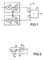
- the inertial unit with integrated GPS receiver 10 comprises, on the one hand, a computer 12 for measuring the state vectors supplied by the inertial unit and, on the other hand, a GPS receiver comprising a computer 14 of the position and speed vectors of the flying machine.
- the computer 12 is associated with a processor 16 in which is installed a Kalman K 1 algorithm of the type with satellite axes which uses, on the one hand, the data supplied by the computer 12 associated with the inertial unit and, on the other hand , to the data of the computer 14 of the GPS receiver and which delivers on its output a state vector which is applied to the first input 18 of a comparator 20.
- the computer 12 and the processor 16 form a single processor.
- a second Kalman K 2 algorithm of the type with geographical axes which receives its data, on the one hand, from the computer 14 of GPS coordinates and, on the other hand, from the computer 12 providing the state vector calculated from the inertial unit.
- the data supplied by the filter K 2 are applied to a second input 24 of the comparator 20.
- the computers 12 and 14 use the same processor.
- processors in which the filters K 1 and K 2 are installed are distinct and of a different nature.
- these processors use different compilers.
- each confidence coordinate X iK1 of the state vector supplied by the filter K 1 is associated with a confidence interval 30 (FIG. 2) which consists of the set of values between X iK1 -r and X iK1 + r.
- the confidence interval is determined so that there is a high probability, for example greater than 99.9%, that the real coordinate is within this confidence interval.
- the filter K 2 provides for the same coordinate a value X iK2 to which a confidence interval is associated, that is to say a set of values between X iK2 -r 'and X iK2 + r'.
- the comparator 20 determines whether the X coordinate iK2 is within the confidence interval 30 and whether the X coordinate iK1 is within the confidence interval 32. If so, the estimated data are reliable and available and we validate those provided by at least one of the filters. On the other hand, if the comparison criterion mentioned above is not satisfied, the data are estimated to be of insufficient reliability. In addition, the inconsistency between the data provided by the two filters is an indication of failure.
Landscapes
- Engineering & Computer Science (AREA)
- Radar, Positioning & Navigation (AREA)
- Remote Sensing (AREA)
- Physics & Mathematics (AREA)
- General Physics & Mathematics (AREA)
- Computer Networks & Wireless Communication (AREA)
- Automation & Control Theory (AREA)
- Position Fixing By Use Of Radio Waves (AREA)
- Navigation (AREA)
Abstract
Description
Claims (5)
- Centrale inertielle à récepteur GPS ou analogue intégré destinée à fournir un vecteur d'état d'un engin volant, cette centrale comprenant des moyens à filtrage de Kalman pour combiner les données provenant de la centrale inertielle et du récepteur GPS ou analogue, caractérisée en ce qu'elle comprend un premier (K1) et un second (K2) filtres de Kalman, chacun d'eux combinant les données de la centrale inertielle et les données du récepteur GPS ou analogue, les deux filtrages de Kalman utilisant des algorithmes différents, des processeurs différents et des compilateurs différents.
- Centrale selon la revendication 1, caractérisée en ce que le premier filtre de Kalman (K1) fait appel à un algorithme à axes satellites et le second filtre de Kalman (K2) fait appel à un algorithme à axes géographiques.
- Centrale selon la revendication 1 ou 2, caractérisée en ce que le premier filtre de Kalman fait appel à un processeur (16) de la centrale inertielle et le second filtre de Kalman fait appel à un processeur (22) du récepteur GPS ou analogue.
- Centrale selon l'une quelconque des revendications précédentes, caractérisée en ce qu'elle comprend des moyens (20) pour comparer les données fournies par les deux filtres de Kalman et pour valider les données fournies par au moins l'un des filtres quand les données ont des valeurs proches et pour fournir un signal d'indication de panne quand les données sont éloignées.
- Centrale selon la revendication 4, caractérisée en ce qu'elle comporte des moyens pour associer à chaque coordonnée du vecteur d'état fournie par chaque filtre de Kalman un intervalle de confiance tel que la coordonnée réelle se trouve avec une probabilité élevée à l'intérieur de cet intervalle, les moyens de comparaison déterminant si, pour chaque coordonnée fournie par le premier filtre de Kalman, la coordonnée correspondante fournie par le second filtre de Kalman se trouve dans l'intervalle de confiance (30) associé à la coordonnée fournie par ce premier filtre et si la coordonnée fournie par le premier filtre de Kalman se trouve dans l'intervalle de confiance (32) associé à la coordonnée correspondante fournie par le second filtre.
Applications Claiming Priority (2)
| Application Number | Priority Date | Filing Date | Title |
|---|---|---|---|
| FR0014491A FR2816703B1 (fr) | 2000-11-10 | 2000-11-10 | Centrale inertielle de navigation comportant un recepteur gps integre |
| FR0014491 | 2000-11-10 |
Publications (3)
| Publication Number | Publication Date |
|---|---|
| EP1205732A2 true EP1205732A2 (fr) | 2002-05-15 |
| EP1205732A3 EP1205732A3 (fr) | 2004-12-15 |
| EP1205732B1 EP1205732B1 (fr) | 2006-03-29 |
Family
ID=8856320
Family Applications (1)
| Application Number | Title | Priority Date | Filing Date |
|---|---|---|---|
| EP01402890A Expired - Lifetime EP1205732B1 (fr) | 2000-11-10 | 2001-11-09 | Centrale inertielle de navigation comportant un récepteur GPS intégré |
Country Status (3)
| Country | Link |
|---|---|
| EP (1) | EP1205732B1 (fr) |
| DE (1) | DE60118326T2 (fr) |
| FR (1) | FR2816703B1 (fr) |
Cited By (4)
| Publication number | Priority date | Publication date | Assignee | Title |
|---|---|---|---|---|
| FR2855922A1 (fr) * | 2003-06-06 | 2004-12-10 | Thales Sa | Procede et dispositif de traitement des informations provenant d'equipements primaires de vol repondants |
| US7409289B2 (en) * | 2004-02-13 | 2008-08-05 | Thales | Device for monitoring the integrity of information delivered by a hybrid INS/GNSS system |
| WO2016041963A1 (fr) * | 2014-09-17 | 2016-03-24 | Continental Teves Ag & Co. Ohg | Localisation redondante au moyen d'un signal gnss |
| CN114815880A (zh) * | 2022-04-01 | 2022-07-29 | 深圳互酷科技有限公司 | 基于手柄的无人机控制方法、装置、设备与可读存储介质 |
Families Citing this family (11)
| Publication number | Priority date | Publication date | Assignee | Title |
|---|---|---|---|---|
| US7889133B2 (en) | 1999-03-05 | 2011-02-15 | Itt Manufacturing Enterprises, Inc. | Multilateration enhancements for noise and operations management |
| US7612716B2 (en) | 1999-03-05 | 2009-11-03 | Era Systems Corporation | Correlation of flight track data with other data sources |
| US7570214B2 (en) | 1999-03-05 | 2009-08-04 | Era Systems, Inc. | Method and apparatus for ADS-B validation, active and passive multilateration, and elliptical surviellance |
| US7739167B2 (en) | 1999-03-05 | 2010-06-15 | Era Systems Corporation | Automated management of airport revenues |
| US7782256B2 (en) | 1999-03-05 | 2010-08-24 | Era Systems Corporation | Enhanced passive coherent location techniques to track and identify UAVs, UCAVs, MAVs, and other objects |
| US7908077B2 (en) | 2003-06-10 | 2011-03-15 | Itt Manufacturing Enterprises, Inc. | Land use compatibility planning software |
| US8446321B2 (en) | 1999-03-05 | 2013-05-21 | Omnipol A.S. | Deployable intelligence and tracking system for homeland security and search and rescue |
| US8203486B1 (en) | 1999-03-05 | 2012-06-19 | Omnipol A.S. | Transmitter independent techniques to extend the performance of passive coherent location |
| US7777675B2 (en) | 1999-03-05 | 2010-08-17 | Era Systems Corporation | Deployable passive broadband aircraft tracking |
| US7667647B2 (en) | 1999-03-05 | 2010-02-23 | Era Systems Corporation | Extension of aircraft tracking and positive identification from movement areas into non-movement areas |
| US7965227B2 (en) | 2006-05-08 | 2011-06-21 | Era Systems, Inc. | Aircraft tracking using low cost tagging as a discriminator |
-
2000
- 2000-11-10 FR FR0014491A patent/FR2816703B1/fr not_active Expired - Fee Related
-
2001
- 2001-11-09 EP EP01402890A patent/EP1205732B1/fr not_active Expired - Lifetime
- 2001-11-09 DE DE60118326T patent/DE60118326T2/de not_active Expired - Fee Related
Non-Patent Citations (2)
| Title |
|---|
| BROATCH S A ET AL: "AN INTEGRATED NAVIGATION SYSTEM MANAGER USING FEDERATED KALMAN FILTERING" PROCEEDINGS OF THE NATIONAL AEROSPACE AND ELECTRONICS CONFERENCE. (NAECON),US,NEW YORK, IEEE, vol. CONF. 43, 20 mai 1991 (1991-05-20), pages 422-426, XP000312679 * |
| SCHWARZ K P ET AL: "AIDED VERSUS EMBEDDED A COMPARISON OF TWO APPROACHES TO GPS/INS INTEGRATION" POSITION LOCATION AND NAVIGATION SYMPOSIUM (PLANS),US,NEW YORK, IEEE, vol. -, 11 avril 1994 (1994-04-11), pages 314-322, XP000489358 ISBN: 0-7803-1436-0 * |
Cited By (5)
| Publication number | Priority date | Publication date | Assignee | Title |
|---|---|---|---|---|
| FR2855922A1 (fr) * | 2003-06-06 | 2004-12-10 | Thales Sa | Procede et dispositif de traitement des informations provenant d'equipements primaires de vol repondants |
| WO2004109516A1 (fr) * | 2003-06-06 | 2004-12-16 | Thales | Procede et dispositif de traitement des informations provenant d'equipements primaires de vol redondants |
| US7409289B2 (en) * | 2004-02-13 | 2008-08-05 | Thales | Device for monitoring the integrity of information delivered by a hybrid INS/GNSS system |
| WO2016041963A1 (fr) * | 2014-09-17 | 2016-03-24 | Continental Teves Ag & Co. Ohg | Localisation redondante au moyen d'un signal gnss |
| CN114815880A (zh) * | 2022-04-01 | 2022-07-29 | 深圳互酷科技有限公司 | 基于手柄的无人机控制方法、装置、设备与可读存储介质 |
Also Published As
| Publication number | Publication date |
|---|---|
| DE60118326T2 (de) | 2006-11-30 |
| FR2816703A1 (fr) | 2002-05-17 |
| FR2816703B1 (fr) | 2003-01-31 |
| EP1205732A3 (fr) | 2004-12-15 |
| DE60118326D1 (de) | 2006-05-18 |
| EP1205732B1 (fr) | 2006-03-29 |
Similar Documents
| Publication | Publication Date | Title |
|---|---|---|
| EP1205732B1 (fr) | Centrale inertielle de navigation comportant un récepteur GPS intégré | |
| EP1989510B1 (fr) | Procédé et dispositif de positionnement hybride | |
| EP0925515B1 (fr) | Procede d'aide a la navigation d'un mobile vers une cible egalement mobile | |
| EP1914561B1 (fr) | Procédé de localisation d'un véhicule par satellites et garantie d'intégrité avec sélection d'un sous-groupe de satellites | |
| CA2468237C (fr) | Centrale de navigation inertielle hybride a integrite amelioree en altitude | |
| EP2987036B1 (fr) | Procede de controle d'integrite et dispositif de fusion-consolidation comprenant une pluralite de modules de traitement | |
| CA2457278C (fr) | Procede et dispositif d'aide au pilotage d'un aeronef lors d'une approche de non precision pendant une phase d'atterrissage | |
| EP1679567A2 (fr) | Architecture d'un système embarque d'aide au pilotage d'un aéronef | |
| EP2225622A1 (fr) | Procede pour l'aide a l'atterrissage d'aeronef utilisant un gps et un mls dans le cadre d'une approche axiale calculee | |
| FR2901363A1 (fr) | Dispositif de navigation aerienne a capteurs inertiels et recepteurs de radionavigation et procede de navigation aerienne utilisant de tels elements | |
| EP2765390B1 (fr) | Système et procédé d'aide à la navigation d'un aéronef | |
| FR2906615A1 (fr) | Dispositif d'estimation du vent pour aeronef et procede associe | |
| WO2024056973A1 (fr) | Procede et dispositif de navigation pour un vehicule, systeme, vehicule, programme d'ordinateur et support d'informations associes | |
| EP4588030A1 (fr) | Procede et dispositif de navigation pour un aeronef, systeme, aeronef, programme d'ordinateur et support d'informations associes | |
| FR2815145A1 (fr) | Procede et systeme de navigation pour aeronef, notamment en phase d'approche | |
| WO2021032749A1 (fr) | Detection d'une operation de leurrage d'un recepteur de signaux satellitaires | |
| EP4217681A1 (fr) | Procédé de recalage sur une pluralité d'amers, produit programme d'ordinateur et dispositif de recalage associés | |
| FR2853062A1 (fr) | Aide a la navigation augmentee en integrite verticale | |
| EP2006707B1 (fr) | Procédé de détermination d'une limite de protection avec compensation des retards de calcul | |
| FR3071624B1 (fr) | Systeme d'affichage, procede d'affichage et programme d'ordinateur associes | |
| FR3033403A1 (fr) | Systeme de fourniture et de surveillance de parametres de vol d'un aeronef | |
| FR3079608A1 (fr) | Procede de geolocalisation d'un drone, systeme de geolocalisation et produit programme d'ordinateur associes | |
| FR3151917A1 (fr) | Procédé d’estimation des coordonnées géographiques d’un aéronef, aéronef équipé d’un dispositif d’estimation de coordonnées géographiques fonctionnant selon ledit procédé | |
| EP4006491A1 (fr) | Système d'aide à la navigation d'un porteur à l'aide d'amers | |
| FR3096142A1 (fr) | Procédé de géolocalisation d'une plateforme se déplaçant en formation avec d'autres plateformes, produit programme d'ordinateur et module de géolocalisation associes |
Legal Events
| Date | Code | Title | Description |
|---|---|---|---|
| PUAI | Public reference made under article 153(3) epc to a published international application that has entered the european phase |
Free format text: ORIGINAL CODE: 0009012 |
|
| AK | Designated contracting states |
Kind code of ref document: A2 Designated state(s): AT BE CH CY DE DK ES FI FR GB GR IE IT LI LU MC NL PT SE TR |
|
| AX | Request for extension of the european patent |
Free format text: AL;LT;LV;MK;RO;SI |
|
| PUAL | Search report despatched |
Free format text: ORIGINAL CODE: 0009013 |
|
| AK | Designated contracting states |
Kind code of ref document: A3 Designated state(s): AT BE CH CY DE DK ES FI FR GB GR IE IT LI LU MC NL PT SE TR |
|
| AX | Request for extension of the european patent |
Extension state: AL LT LV MK RO SI |
|
| 17P | Request for examination filed |
Effective date: 20050404 |
|
| AKX | Designation fees paid |
Designated state(s): DE FR GB |
|
| GRAP | Despatch of communication of intention to grant a patent |
Free format text: ORIGINAL CODE: EPIDOSNIGR1 |
|
| GRAS | Grant fee paid |
Free format text: ORIGINAL CODE: EPIDOSNIGR3 |
|
| GRAA | (expected) grant |
Free format text: ORIGINAL CODE: 0009210 |
|
| AK | Designated contracting states |
Kind code of ref document: B1 Designated state(s): DE FR GB |
|
| REG | Reference to a national code |
Ref country code: GB Ref legal event code: FG4D Free format text: NOT ENGLISH |
|
| REF | Corresponds to: |
Ref document number: 60118326 Country of ref document: DE Date of ref document: 20060518 Kind code of ref document: P |
|
| GBT | Gb: translation of ep patent filed (gb section 77(6)(a)/1977) |
Effective date: 20060524 |
|
| PLBE | No opposition filed within time limit |
Free format text: ORIGINAL CODE: 0009261 |
|
| STAA | Information on the status of an ep patent application or granted ep patent |
Free format text: STATUS: NO OPPOSITION FILED WITHIN TIME LIMIT |
|
| 26N | No opposition filed |
Effective date: 20070102 |
|
| PG25 | Lapsed in a contracting state [announced via postgrant information from national office to epo] |
Ref country code: DE Free format text: LAPSE BECAUSE OF NON-PAYMENT OF DUE FEES Effective date: 20070601 |
|
| GBPC | Gb: european patent ceased through non-payment of renewal fee |
Effective date: 20061109 |
|
| REG | Reference to a national code |
Ref country code: FR Ref legal event code: ST Effective date: 20070731 |
|
| PG25 | Lapsed in a contracting state [announced via postgrant information from national office to epo] |
Ref country code: GB Free format text: LAPSE BECAUSE OF NON-PAYMENT OF DUE FEES Effective date: 20061109 |
|
| PG25 | Lapsed in a contracting state [announced via postgrant information from national office to epo] |
Ref country code: FR Free format text: LAPSE BECAUSE OF NON-PAYMENT OF DUE FEES Effective date: 20061130 |