EP1217331A1 - Méthode et système pour fixer le temps de trajet et méthode et système de calcul de route et son utilisation - Google Patents
Méthode et système pour fixer le temps de trajet et méthode et système de calcul de route et son utilisation Download PDFInfo
- Publication number
- EP1217331A1 EP1217331A1 EP01129869A EP01129869A EP1217331A1 EP 1217331 A1 EP1217331 A1 EP 1217331A1 EP 01129869 A EP01129869 A EP 01129869A EP 01129869 A EP01129869 A EP 01129869A EP 1217331 A1 EP1217331 A1 EP 1217331A1
- Authority
- EP
- European Patent Office
- Prior art keywords
- travel
- time
- travel time
- vehicle
- data
- Prior art date
- Legal status (The legal status is an assumption and is not a legal conclusion. Google has not performed a legal analysis and makes no representation as to the accuracy of the status listed.)
- Granted
Links
Images


Classifications
-
- G—PHYSICS
- G08—SIGNALLING
- G08G—TRAFFIC CONTROL SYSTEMS
- G08G1/00—Traffic control systems for road vehicles
- G08G1/09—Arrangements for giving variable traffic instructions
- G08G1/0962—Arrangements for giving variable traffic instructions having an indicator mounted inside the vehicle, e.g. giving voice messages
- G08G1/0968—Systems involving transmission of navigation instructions to the vehicle
- G08G1/096805—Systems involving transmission of navigation instructions to the vehicle where the transmitted instructions are used to compute a route
- G08G1/096811—Systems involving transmission of navigation instructions to the vehicle where the transmitted instructions are used to compute a route where the route is computed offboard
-
- G—PHYSICS
- G01—MEASURING; TESTING
- G01C—MEASURING DISTANCES, LEVELS OR BEARINGS; SURVEYING; NAVIGATION; GYROSCOPIC INSTRUMENTS; PHOTOGRAMMETRY OR VIDEOGRAMMETRY
- G01C21/00—Navigation; Navigational instruments not provided for in groups G01C1/00 - G01C19/00
- G01C21/26—Navigation; Navigational instruments not provided for in groups G01C1/00 - G01C19/00 specially adapted for navigation in a road network
- G01C21/34—Route searching; Route guidance
- G01C21/3453—Special cost functions, i.e. other than distance or default speed limit of road segments
- G01C21/3492—Special cost functions, i.e. other than distance or default speed limit of road segments employing speed data or traffic data, e.g. real-time or historical
-
- G—PHYSICS
- G08—SIGNALLING
- G08G—TRAFFIC CONTROL SYSTEMS
- G08G1/00—Traffic control systems for road vehicles
- G08G1/09—Arrangements for giving variable traffic instructions
- G08G1/0962—Arrangements for giving variable traffic instructions having an indicator mounted inside the vehicle, e.g. giving voice messages
- G08G1/0968—Systems involving transmission of navigation instructions to the vehicle
- G08G1/096805—Systems involving transmission of navigation instructions to the vehicle where the transmitted instructions are used to compute a route
- G08G1/096827—Systems involving transmission of navigation instructions to the vehicle where the transmitted instructions are used to compute a route where the route is computed onboard
-
- G—PHYSICS
- G08—SIGNALLING
- G08G—TRAFFIC CONTROL SYSTEMS
- G08G1/00—Traffic control systems for road vehicles
- G08G1/20—Monitoring the location of vehicles belonging to a group, e.g. fleet of vehicles, countable or determined number of vehicles
Definitions
- This invention relates to a method for setting in advance a travel time in a required section of road on a passage route and a system for implementing the method, and also a method and a system of performing route calculation for navigation or the like using the method of setting the travel time.
- the navigation system calculates a route connecting a starting location and a destination location based on requirements established by a user, and guides the user along a route determined by the resulting route calculation.
- the user can establish various requirements, e.g., distance priority, kinds of roadways making up the route such as a national road, toll road and expressway/motorway, use or non-use of a ferry boat, and traffic restrictions, for allowing the desired route calculation to be done.
- the route calculation in the navigation system as described above does not conventionally involve actual traffic situations such as a traffic jam. If the route calculation is done on the basis of the requirement, for example, of the shortest route or of use of an expressway/motorway, the automobile may not always arrive at the destination location in the minimum time. There may be a situation in which the automobile is caught in a traffic jam on the way and much more time is required for travelling to the destination location than that required for travelling along an alternative route that includes a detour.
- the traffic situation varies every moment and differs according to the time of day. If the route calculation is made involving a travel time assumed across the board, the route calculation is not always made in line with the actual condition.
- the present invention has been made to solve the above problems associated with the route calculation conventionally made in a navigation system or the like as described above.
- a method for setting a travel time has the feature of including the steps: receiving a position detection signal transmitted from a travelling vehicle to detect a position of the vehicle; sensing whether or not the vehicle passes a starting node of a required link on a road network for storage the passing time when the vehicle passes the starting node; sensing whether or not the vehicle passes an end node of the required link on the road network for storage of the passing time when the vehicle passes the end node; and calculating a travel time for the link from the passing times at the starting node and the end node of the link.
- the method for setting the travel time by receiving a position detection signal indicating the vehicle position which is transmitted via a mobile communication network from the travelling vehicle fitted with a navigation system or the like having communication facility, it is monitored whether or not the vehicle subjected to the position detection passes each of starting and end nodes of a link, subjected to measurement, on a road network.
- the vehicle subjected to the position detection passes both the starting and end nodes of the link subjected to the measurement on the road network, each of the times passing the respective starting and end nodes is detected and stored.
- the time required to travel the link connecting the starting node and the end node is calculated from the detected passing times.
- the travel time in each of the links making up the road network is set based on the position detection signal transmitted from the vehicle which has actually travelled the link.
- This method achieves the setting of the travel time matching the actual traffic situations including a traffic jam and the like as compared with a travel time assumed through a calculation from road data of a distance and the like.
- the travel time data for each link on the road network set by the present invention is used as reference data in route calculation in a navigation system for example, proper route calculation is made in conformity to actual traffic situations.
- the travel time data set by the present invention is used as traffic information, it is further possible to provide proper traffic information, and therefore to expect the effects of relieving traffic congestion.
- the method for setting the travel time according to a second aspect of the present invention has the feature, in addition to the configuration of the first aspect, that the step of calculating the travel time is performed in each required time slot.
- the setting of the travel time in each link of the road network based on the position detection signal transmitted from the travelling vehicle is performed separately in given time slots, for example, the time slots of morning, afternoon and night or the time slots of the commuting hours in morning and evening and other time slots.
- time slots for example, the time slots of morning, afternoon and night or the time slots of the commuting hours in morning and evening and other time slots.
- time slot is set to be shorter, it is possible to set a travel time much more closely conforming to the actual traffic situations.
- the method for setting the travel time according to a third aspect of the present invention has the feature, in addition to the configuration of the second aspect, that in the step of calculating the travel time, the travel time is calculated by averaging a plurality of data representing the travel times of the vehicles detected within the required time slot.
- a plurality of the travel times are averaged on the basis of travel times which are detected from the plurality of vehicles passing the link to be measured within the required time slot.
- a method for setting a travel time according to a fourth aspect of the present invention has the feature, in addition to the configuration of the third aspect, of further including a step of calculating a travel time in the link from road data and a set speed instead of the travel time measured when the number of data representing the travel times of the vehicles detected within the required time slot is lower than a specified number set in advance.
- the travel time is assumed on the basis of the known road data, i.e. the distance of a link, the width of a road, the number of lanes, kinds of road such as an expressway/motorway or an ordinary road, speed limits, and so on, instead of using the data of the travel times obtained from the detection.
- the travel time is allowed to be set even if no vehicle passes within the time slot subjected to the measurement. Further, if the number of vehicles passing is below the specified number, it is possible to exclude the influence of an extension of the travel time caused by individual circumstances, e.g. a failure, produced in the vehicles, for example.
- a method for setting a travel time according to a fifth aspect of the present invention has the feature, in addition to the configuration of the first aspect, of further including a step of calculating an average speed per hour from the calculated travel time and the distance of the link.
- the average speed per hour of the vehicles in the link is calculated from the measured travel time, to be used as reference data for the provision of traffic information or route calculation in navigation.
- a method for setting a travel time according to a sixth aspect of the present invention has the feature, in addition to the configuration of the first aspect, of further including a step of storing data representing the calculated travel time through an overwriting operation.
- the data on the travel time in each of the links making up the road network is updated to latest data at all times, to be made available for use.
- a system for setting a travel time has the feature of including: vehicle-position detection means for receiving a position detection signal transmitted from a travelling vehicle to detect a vehicle position; node-passing-time detection means for sensing from the position detection of said vehicle-position detection means whether or not the vehicle passes a required node on a road network, to detect the node-passing time of the vehicle; and travel-time calculation means for calculating a travel time in a link connecting the two required nodes from the node passing times of the vehicle passing the two required nodes on the road network which are detected by the node-passing-time detection means.
- the vehicle-position detection means receives a position detection signal indicating the vehicle position which is transmitted via a mobile communication network from the travelling vehicle fitted with a navigation system or the like having communication facility.
- the node-passing-time detection means monitors whether or not the vehicle subjected to the position detection passes each of the starting and end nodes of the link, subjected to the measurement, on the road network. Upon sensing that the vehicle has passed both the starting and end nodes of the link subjected to the measurement on the road network, the node-passing-time detection means detects the passing times for storage.
- the travel-time calculation means calculates the time required to travel the link connecting the starting node and the end node from the above passing times at the respective starting and end nodes, and sets the results as the travel time in the corresponding link.
- the travel time regarding each of the links making up the road network is set on the basis of the position detection signal transmitted from the vehicle actually travelling the link. For this reason, as compared with a value calculated from the road data of a distance and others, the system is able to set the travel time in conformity with the actual traffic situations including traffic congestion and the like.
- the system for setting the travel time according to an eighth aspect of the present invention has the feature, in addition to the configuration of the seventh aspect, that the travel-time calculation means calculates the travel time for each required time slot.
- the travel-time calculation means performs the setting of the travel time in each link of the road network based on the position detection signal transmitted from the travelling vehicle, in separate given time slots, for example, the time slots of morning, afternoon and night or the time slots of the commuting hours in morning and evening and other time slots.
- This configuration allows the travel time to be set in more conformity with the actual traffic situations.
- the system for setting the travel time according to a ninth aspect of the present invention has the feature, in addition to the configuration of the eighth aspect, that the travel-time calculation means averages a plurality of data representing the travel times of the vehicles detected within the required time slot for calculating the travel time.
- the travel-time calculation means averages a plurality of travel times based on the travel times detected from a plurality of vehicles which pass the link, subjected to the measurement, within the required time slot for the setting of the travel time.
- the system for setting the travel time according to a tenth aspect of the present invention has the feature, in addition to the configuration of the ninth aspect, that the travel-time calculation means calculates the travel time in the link from road data and a set speed instead of the detected node passing time when the number of data representing the travel times of a plurality of the vehicles detected within the required time slot is lower than a specified number set in advance.
- the travel-time calculation means calculates the travel time on the basis of the known road data, i.e. the distance between the nodes, the width of a road, the number of lanes, kinds of road such as a expressway/motorway or an ordinary road, speed limits, and so on, instead of using the data of the travel times obtained through the detection.
- the travel time is allowed to be set even if no vehicle passes within the time slot subjected to the measurement. Further, when the number of vehicles passing is below the specified number, it is possible to exclude the influence of an extension of the travel time caused by individual circumstances, e.g. a failure, produced in the vehicles, for example.
- the system for setting the travel time according to an eleventh aspect of the present invention has the feature, in addition to the configuration of the seventh aspect, of further including speed-per-hour calculation means for calculating an average speed per hour from the travel time calculated by the travel-time calculation means and the distance of the link.
- the speed-per-hour calculation means calculates the average speed per hour of the vehicles in the link from the measured travel time, to be used for the provision of traffic information or route calculation in navigation.
- the system for setting the travel time according to a twelfth aspect of the present invention has the feature, in addition to the configuration of the seventh aspect, of further including travel-time data storage means for storing data representing the travel time calculated by the travel-time calculation means.
- the data of the travel time for each of the links making up the road network is stored in the travel-time data storage means, and is read out from the travel-time data storage means to be used as the reference data for the provision of traffic information or route calculation for navigation.
- the system for setting the travel time according to a thirteenth aspect of the present invention has the feature, in addition to the configuration of the twelfth aspect, that the travel-time data storage means stores the data representing the travel time through an overwriting operation.
- the data regarding the travel time in each of the links making up the road network is updated to the latest data at all times for storage in the travel-time data storage means.
- a method for route calculation according to a fourteenth aspect of the present invention has the feature of including the steps of: detecting node-passing times of a vehicle passing two required nodes on a road network on the basis of vehicle positions detected by position detection signals transmitted from the travelling vehicle; calculating a travel time in a link connecting the two nodes from the detected node-passing times for storing the calculated data for each link on the road network; and calculating a route connecting a set starting location and a set destination location on the basis of the stored travel time data.
- a position detection signal indicating the vehicle position which is transmitted via mobile communication network from the travelling vehicle fitted with a navigation system or the like having communication facility it is monitored whether or not the vehicle subjected to the position detection passes each of the two required nodes on the road network.
- the vehicle subjected to the position detection passes both the starting and end nodes of a link subjected to the measurement on the road network, the times of passing the respective starting and end nodes are detected and stored. Then, the time required for the vehicle to travel the link connecting the two nodes is calculated from the stored times of passing the two nodes, and is stored for each of the links making up the road network.
- the above stored travel time data for each of the links making up the road network is read for use as the basic data in the route calculation.
- the route is calculated based on the travel time data for each of the links of the road network which is set based on the position detection signal transmitted from the vehicle which has actually traveled.
- the method achieves route calculation matching the actual traffic situations, e.g. traffic congestion, as compared with route calculation based on an assumed travel time calculated from the road data of the distance and the like.
- the method for the route calculation according to a fifteenth aspect of the present invention has the feature, in addition to the configuration of the fourteenth aspect, that the step of calculating the travel time is performed in each required time slot, and the step of calculating the route connecting the set starting location and the set destination location is performed based on the travel time data for the corresponding time slot.
- the setting of the travel time in each of the links of the road network is performed separately in given time slots, for example, the time slots of morning, afternoon and night or the time slots of the commuting hours in morning and evening and other time slots. Then, the route calculation subject to the condition of the travel time in the navigation system is performed with reference to the data of the travel time corresponding to the time slot in which the route to be set through this route calculation will be used.
- the method for the route calculation according to a sixteenth aspect of the present invention has the feature, in addition to the configuration of the fifteenth aspect, that in the step of calculating the travel time, the travel time is calculated by averaging a plurality of data representing the travel times of the vehicles detected within the required time slot, and the step of calculating the route connecting the set starting and destination locations is performed on the basis of the averaged travel-time data for the corresponding time slot.
- the plurality of the travel times are averaged for setting the travel time which is to be a reference in the route calculation in the navigation system.
- the method for the route calculation a route according to a seventeenth aspect of the present invention has the feature, in addition to the configuration of the sixteenth aspect, of further including a step of calculating a travel time in the link from road data and a set speed for storage instead of the travel time measured when the number of data representing the travel times of a plurality of the vehicles detected within the required time slot is lower than a specified number set in advance, in which the step of calculating the route connecting the set starting and destination locations is performed on the basis of the travel time data defined by the road data and the set speed.
- the travel time is assumed by use of the known road data, i.e. the distance between the nodes, the width of a road, the number of lanes, kinds of road such as an expressway/motorway or an ordinary road, speed limits, and so on, instead of the use of the travel time data obtained through the measurement. Then, in performing route calculation subject to the condition of the travel time in the navigation system, the route calculation is performed with reference to the assumed travel time.
- the travel time can be set even if no vehicle passes within the time slot in which the measurement is performed. Further, if the number of vehicles passing is below the specified number, it is possible to perform the route calculation with excluding the influence of an extension of the travel time caused by individual circumstances, e.g. a failure, produced in the vehicles.
- a system for route calculation has the feature of including: vehicle-position detection means for receiving a position detection signal transmitted from a travelling vehicle to detect a vehicle position; node-passing-time detection means for sensing from the position detection of the vehicle-position detection means whether or not the vehicle passes a required node on a road network, to detect a node passing time of the vehicle; travel time calculation means for calculating a travel time in a link connecting the two required nodes from the node passing times when the vehicle passes the two required nodes on the road network which are detected by the node-passing-time detection means; travel-time data storage means for storing the data representing the travel time calculated by the travel time calculation means for each link on the road network; and route calculation means for calculating a route connecting a set starting location and a set destination on the basis of the travel time data stored in the travel-time data storage means.
- the vehicle-position detection means receives a position detection signal indicating the vehicle position which is transmitted via a mobile communication network from the travelling vehicle fitted with a navigation system or the like having communication facility.
- the node-passing-time detecting means monitors whether or not the vehicle subjected to the position detection passes each of the two nodes on the road network. Upon sensing that the vehicle has passed each of the two nodes on the road network, the node-passing-time detection means detects the passing times for storage.
- the travel-time calculation means calculates the time required to travel the link connecting the starting node and the end node from the detected times of passing the starting and end nodes, to set the calculated result as the travel time for the corresponding link.
- the route calculation means reads the stored travel time data for each of the links making up the road network for use as basic data in the route calculation.
- the travel time regarding each of the links making up the road network is set based on the position detection signals transmitted from the vehicle which has actually traveled the link. For this reason, the route is calculated in conformity with the actual traffic situations, e.g. traffic congestion, as compared with route calculation with reference to the assumed travel time calculated from the road data of the distance and other factors.
- the system for the route calculation according to a nineteenth aspect of the present invention has the feature, in addition to the configuration of the eighteenth aspect, that the travel time calculation means calculates the travel time for each required time slot and stores it in the travel-time data storage means, and the route calculation means calculates the route connecting the set starting location and the set destination on the basis of the travel time data for the corresponding time slot read out from the travel-time data storage means.
- the travel time calculation means calculates the travel time in each of the links of the road network in separate given time slots, for example, the time slots of morning, afternoon and night or the time slots of the commuting hours in morning and evening and other time slots.
- the route calculating means performs the route calculation subject to the condition of the travel time with reference to the data of the travel time corresponding to the time slot in which the route to be set through this route calculation will be used.
- the system for the route calculation according to a twentieth aspect of the present invention has the feature, in addition to the configuration of the nineteenth aspect, that the travel-time calculation means averages a plurality of data representing the travel times of the vehicles detected within the required time slot for the calculation of the travel time, and stores the averaged travel time data in the travel-time data storage means, and the route calculation means calculates the route connecting the set starting location and the set destination on the basis of the averaged travel time data for the corresponding time slot read out from the travel-time data storage means.
- the travel time calculation means averages a plurality of travel times on the basis of the travel times detected from a plurality of vehicles which pass the link, subjected to measurement, within the required time slot, to set the travel time serving as a reference in the route calculation.
- the travel-time data storage means stores the averaged travel time data.
- the route calculation means calculates the route connecting the set starting and destination locations with reference to the averaged travel time data for the corresponding time slot read from the travel-time data storage means.
- the system for the route calculation according to a twenty-first aspect of the present invention has the feature, in addition to the configuration of the twentieth aspect, that the travel time calculation means calculates the travel time in the link from road data and a set speed instead of the measured travel time when the number of data representing the travel times of a plurality of the vehicles detected within the required time slot is lower than a specified number set in advance, and stores the calculated result in the travel-time data storage means, and the route calculating means calculates the route connecting the set starting location and the set destination location on the basis of the travel time data, defined by the road data and set speed, read out from the travel-time data storage means.
- the travel time calculation means sets the travel time
- the travel time is assumed through a calculation using the known road data, i.e. the distance between the nodes, a width of the road, the number of lanes, kinds of road such as a expressway/motorway or an ordinary road, speed limits, and so on, instead of the use of the travel time data obtained through measurement.
- the route calculation means performs route calculation subject to the conditions of the travel time, the assumed travel time is used as the reference data.
- the travel time can be set even if no vehicle travels through within the time slot in which the measurement is performed. Further, if the number of vehicles passing is below the specified number, it is possible to perform the route calculation excluding the influence of an extension of the travel time caused by individual circumstances, e.g. a failure, produced in the vehicles.
- the system for the route calculation according to a twenty-second aspect of the present invention has the feature, in addition to the configuration of the eighteenth aspect, that the travel-time data storage means stores the calculated travel time data through an overwriting operation.
- the data of the travel times in the links making up the road network are updated to latest data at all times and are stored in the travel time data storing means, leading to the route calculation most closely matching the actual conditions.
- a method and system for setting a travel time according to the present invention is applicable for use with a traffic-information-providing service for indicating the time required to reach a destination, for example.
- a traffic-information-providing service for indicating the time required to reach a destination, for example.
- the following description will use an example where the present invention is applied to a communication navigation system in which information needed for navigation, such as map information, is provided from a navigation site, via the Internet, to a vehicle-mounted navigation system.
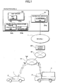
- Fig. 1 is a system configuration diagram illustrating an example of the embodiment of a communication navigation system to which the present invention is applied.
- a navigation site S for providing navigation data to navigation systems is connected to the Internet I.
- the navigation site S includes a navigation server S1 for providing a variety of navigation data such as guidance data and retrieval data which are accumulated in a navigation database S1a, and for exercising control of the communication of data between the navigation system 2 and the navigation site S which are connected through the Internet I; a map server S2 for providing map data accumulated in a map database S2a; and a route calculation server S3 for calculating a route based on a variety of data including travel time data for route calculation as described later which are accumulated in a road network database S3a and a route calculation database S3b.
- a navigation server S1 for providing a variety of navigation data such as guidance data and retrieval data which are accumulated in a navigation database S1a, and for exercising control of the communication of data between the navigation system 2 and the navigation site S which are connected through the Internet I
- a map server S2 for providing map data accumulated in a map database S2a
- a route calculation server S3 for calculating a route based on a variety of data including travel time
- the navigation server S1 has a program designed, upon an access from the navigation system 2 mounted in the vehicle 1 to the navigation server S through the Internet I, to receive a navigation setting input set in the navigation system 2 and to transmit a variety of guidance data such as data for displaying a guiding route and data for voice guidance and a variety of retrieval data for guidance which are accumulated in the navigation database S1a from the navigation database S1a to the navigation system 2; and a program designed to control the communication for supplying map data between the navigation system 2 and the map server S2, the communication of the route calculation data between the navigation system 2 and the route calculation server S3, and so on.
- the map server S2 searches the map database S2a based on the display setting input entered into the navigation system 2, to read map data and data representing landmarks and the like on a map accumulated in the map database S2a, and transmits the read data to the navigation system 2 to allow it to display the read data on the display screen of the navigation system 2.
- the route calculation server S3 calculates, on the basis of the route setting requirement entered into the navigation system 2, a route matching the entered route setting requirement from the road network data accumulated in the road network database S3a and the route calculation data accumulated in the route calculation database S3b, and transmits the calculation results to the navigation system 2 to allow the navigation system 2 to display the route for guidance on the display screen.
- the route calculation database S3b of the route calculation server S3 includes a travel time data area for recording data representing the travel time between nodes on a road network which is used for performing a route calculation with reference to the travel time.
- the travel time data to be recorded in the travel time data area is defined through the travel time measurement program installed into the route calculation server S3 as follows.
- Fig. 2 shows a flow chart illustrating steps of setting the travel time data to be recorded in the route calculation database S3b through the travel time measurement program in the route calculation server S3.
- the route calculation server S3 sets a timer in each time slot in which a travel time is measured (step s1), to start the measurement of the travel time.
- the times are set in given time slots, for example, the time slots of morning, afternoon and night or the time slots of the commuting hours in morning and evening and other time slots. Setting a time slot to be shorter allows the measurement of the travel time in line with the actual traffic situations.
- the route calculation server S3 receives a detection signal of the position of a travelling vehicle detected by GPS (Global Positioning System) from the vehicle fitted with the navigation system 2 which is connected to the navigation site S through the mobile communication network N1, the public switched phone network N2, the access server AS and the Internet I (step s2).
- GPS Global Positioning System
- the server S3 Based on the received travel position detection signal, the server S3 monitors whether or not the vehicle passes a starting node on a given link, subjected to the measurement, on the road network (step s3).
- the server S3 Upon sensing that the vehicle has passed the starting node at step s3, the server S3 stores the passing time when the vehicle passes the starting node (step s4).
- the server S3 further monitors from the travel position detection signals continuously transmitted from the vehicle whether or not the vehicle passes an end node of the link to be measured (step s5). Upon sensing that the vehicle has passed the end node, the server S3 stores the passing time when the vehicle passes the end node (step s6).
- the server S3 calculates the time required to travel the link subjected to measurement (the required travel time) from the times of respectively passing the starting and end nodes and stores the calculated result (step s7).
- the server S3 further calculates speed per hour of the vehicle on the basis of the calculated required travel time and the distance of each link stored in advance in the route calculation database S3b, and stores the calculated result (step s8).
- the server S3 performs the detection of the required travel time and the mean speed per hour on each of a plurality of vehicles which travel the link subjected to measurement within the time slot set by the timer (step s9).
- the server S3 determines whether or not the number of vehicles subjected to the detection of the required travel time and speed per hour within the time slot set by the timer reaches a specified number set in advance (step s10).
- the server S3 calculates a average value of the required travel times from a plurality of time data representing the required travel times detected (step s11), then calculates a average value of the speed per hour from a plurality of speed data representing the speeds per hour of the vehicles subjected to the detection (step s12).
- the server S3 calculates the travel time based on known road data (the distance between nodes, the width of a road, the number of lanes, kinds of road such as a expressway/motorway or an ordinary road, speed limits, and so on) accumulated in advance in the route calculation database S3b (step s13).
- the server S3 records the calculated average required-travel-times and the calculated average speeds-per-hour as described above in the route calculation database S3b as the travel time for the link subjected to the measurement (step s14).
- step s14 when the sever S3 calculated the travel time by use of the known road data at step s13, the server S3 records the travel time calculated at step s13 and speed per hour used in the travel-time calculation in the route calculation database S3b as the travel time of the link subjected to the measurement.
- the server S3 constantly measures the travel time between nodes on the road network as described above, and overwrites the travel time data stored in the route calculation database S3b whenever a time slot subjected to the measurement has elapsed, to update it to the latest travel time at all times.
- the vehicle-mounted navigation system 2 While the vehicle-mounted navigation system 2 is connected via the Internet I to the navigation site S, a starting location and a destination for route calculation are entered into the navigation system 2, and further a required time is entered as the requirement for the route calculation. Then, the data representing the requirements for the route calculation is transmitted through the navigation server S1 of the navigation site S to the route calculation server S3.
- the route calculation server S3 searches the travel time data, which are set by the aforementioned method and recorded in the route calculation database S3b, on the basis of the road network data accumulated in the road network database S3a, to calculate a route matching the requirements by use of a conventionally known route-calculation algorithm or the like.
- the shortest distance is the route from node A to node F by way of nodes B and E in that order.
- the route calculation database S3b the data representing the sum of the travel times of a link b between nodes B and C
- a link c between nodes C and D and a link d between the nodes D and E the route by way of nodes C, D and E in that order has a shorter travel time.
- the route calculation server S3 selects the route from node A to node F by way of nodes B, C, D and E in that order, and transmits the resulting route calculation data together with the guidance data, read from the navigation database S1 of the navigation server S1, to the navigation system 2 to allow it to guide the vehicle 1 to the destination location.
- the travel time data recorded in the route calculation database S3b and used in the route calculation are updated to the latest travelling data at all times, leading to route calculation in line with actual traffic situations when it is performed with reference to the travel time.
- the travel times are set based on the known road data. In such a case, however, the chances of, for example, a traffic jam occurring are remote because of a lower number of vehicle travelling in the time slot. Hence, there is no great difference from the actual required travel time, resulting in route calculation matching actual conditions.
- route calculation conforming to actual traffic situations as described holds promise of the effects of relieving traffic congestion.
Landscapes
- Engineering & Computer Science (AREA)
- Radar, Positioning & Navigation (AREA)
- Remote Sensing (AREA)
- Physics & Mathematics (AREA)
- General Physics & Mathematics (AREA)
- Automation & Control Theory (AREA)
- Traffic Control Systems (AREA)
- Navigation (AREA)
- Information Retrieval, Db Structures And Fs Structures Therefor (AREA)
Applications Claiming Priority (2)
| Application Number | Priority Date | Filing Date | Title |
|---|---|---|---|
| JP2000387437 | 2000-12-20 | ||
| JP2000387437A JP2002190091A (ja) | 2000-12-20 | 2000-12-20 | 走行時間設定方法および装置並びにこれを利用した経路計算方法および装置 |
Publications (2)
| Publication Number | Publication Date |
|---|---|
| EP1217331A1 true EP1217331A1 (fr) | 2002-06-26 |
| EP1217331B1 EP1217331B1 (fr) | 2008-06-25 |
Family
ID=18854368
Family Applications (1)
| Application Number | Title | Priority Date | Filing Date |
|---|---|---|---|
| EP01129869A Expired - Lifetime EP1217331B1 (fr) | 2000-12-20 | 2001-12-14 | Méthode et système pour fixer le temps de trajet et méthode et système de calcul de route et son utilisation |
Country Status (4)
| Country | Link |
|---|---|
| US (1) | US6915207B2 (fr) |
| EP (1) | EP1217331B1 (fr) |
| JP (1) | JP2002190091A (fr) |
| DE (1) | DE60134529D1 (fr) |
Cited By (3)
| Publication number | Priority date | Publication date | Assignee | Title |
|---|---|---|---|---|
| WO2008002034A1 (fr) | 2006-06-27 | 2008-01-03 | Ktfreetel Co., Ltd. | Procédé, dispositif et support enregistré ayant un procédé enregistré, pour fournir des informations de direction conformément à des rapports de condition de circulation en temps réel |
| EP1995563A1 (fr) | 2007-05-21 | 2008-11-26 | Navigon AG | Procédé destiné au fonctionnement d'un système de navigation |
| EP2814002A4 (fr) * | 2012-02-09 | 2015-05-06 | Igor Yurievich Matsur | Procédé de contrôle automatique de parcage de véhicules de transport |
Families Citing this family (38)
| Publication number | Priority date | Publication date | Assignee | Title |
|---|---|---|---|---|
| US7221287B2 (en) | 2002-03-05 | 2007-05-22 | Triangle Software Llc | Three-dimensional traffic report |
| JP3988865B2 (ja) * | 2002-04-12 | 2007-10-10 | パイオニア株式会社 | 案内誘導装置、案内誘導システム、その方法、そのプログラム、および、そのプログラムを記録した記録媒体 |
| JPWO2003093766A1 (ja) * | 2002-04-30 | 2005-09-08 | 株式会社日立製作所 | 通信型ナビゲーションシステムおよびナビゲーション方法 |
| JP4051699B2 (ja) * | 2002-05-09 | 2008-02-27 | 日本電気株式会社 | Gps搭載携帯電話機 |
| US6850844B1 (en) * | 2002-06-28 | 2005-02-01 | Garmin Ltd. | Portable navigation device with integrated GPS and dead reckoning capabilities |
| US6801855B1 (en) | 2002-06-28 | 2004-10-05 | Garmin Ltd. | Systems and methods with integrated GPS and dead reckoning capabilities |
| US20040006425A1 (en) * | 2002-07-03 | 2004-01-08 | Terragraphix, Inc. | System for communicating and associating information with a geographic location |
| US7197320B2 (en) * | 2003-07-02 | 2007-03-27 | Joseph Joseph | System for managing traffic patterns using cellular telephones |
| WO2005013063A2 (fr) | 2003-07-25 | 2005-02-10 | Landsonar, Inc. | Systeme et procede pour determiner une heure de depart recommandee |
| US7908080B2 (en) | 2004-12-31 | 2011-03-15 | Google Inc. | Transportation routing |
| US20060200303A1 (en) * | 2005-02-24 | 2006-09-07 | Fuentes Jorge S | The static or dynamic roadway travel time system to determine the path with least travel time between two places |
| US8112219B2 (en) * | 2005-11-11 | 2012-02-07 | GM Global Technology Operations LLC | System for and method of monitoring real time traffic conditions using probe vehicles |
| US8982116B2 (en) | 2009-03-04 | 2015-03-17 | Pelmorex Canada Inc. | Touch screen based interaction with traffic data |
| US9046924B2 (en) | 2009-03-04 | 2015-06-02 | Pelmorex Canada Inc. | Gesture based interaction with traffic data |
| US8619072B2 (en) | 2009-03-04 | 2013-12-31 | Triangle Software Llc | Controlling a three-dimensional virtual broadcast presentation |
| US8718910B2 (en) | 2010-11-14 | 2014-05-06 | Pelmorex Canada Inc. | Crowd sourced traffic reporting |
| US8583367B2 (en) | 2011-01-07 | 2013-11-12 | Honda Motor Co., Ltd. | System and method for displaying a route based on a vehicle state |
| WO2012159083A2 (fr) | 2011-05-18 | 2012-11-22 | Triangle Software Llc | Système permettant d'utiliser des données de trafic et des données d'efficacité de conduite |
| US10520581B2 (en) * | 2011-07-06 | 2019-12-31 | Peloton Technology, Inc. | Sensor fusion for autonomous or partially autonomous vehicle control |
| US20170242443A1 (en) | 2015-11-02 | 2017-08-24 | Peloton Technology, Inc. | Gap measurement for vehicle convoying |
| US8744666B2 (en) | 2011-07-06 | 2014-06-03 | Peloton Technology, Inc. | Systems and methods for semi-autonomous vehicular convoys |
| US10474166B2 (en) | 2011-07-06 | 2019-11-12 | Peloton Technology, Inc. | System and method for implementing pre-cognition braking and/or avoiding or mitigation risks among platooning vehicles |
| US10520952B1 (en) | 2011-07-06 | 2019-12-31 | Peloton Technology, Inc. | Devices, systems, and methods for transmitting vehicle data |
| CA2883973C (fr) | 2012-01-27 | 2021-02-23 | Edgar Rojas | Estimation des distributions temporelles de parcours sur des arteres signalisees |
| US10223909B2 (en) | 2012-10-18 | 2019-03-05 | Uber Technologies, Inc. | Estimating time travel distributions on signalized arterials |
| US9098386B1 (en) * | 2012-12-31 | 2015-08-04 | Amdocs Software Systems Limited | System, method, and computer program for determining a subjective distance between two locations |
| US11294396B2 (en) | 2013-03-15 | 2022-04-05 | Peloton Technology, Inc. | System and method for implementing pre-cognition braking and/or avoiding or mitigation risks among platooning vehicles |
| CA2907452A1 (fr) | 2013-03-15 | 2014-09-18 | Peloton Technology Inc. | Systemes et procedes de circulation en peloton de vehicules |
| US20150095157A1 (en) * | 2013-09-30 | 2015-04-02 | Mapquest, Inc. | Methods and systems for defining targeted geographic zones for delivering electronic content |
| US10712748B2 (en) | 2015-08-26 | 2020-07-14 | Peloton Technology, Inc. | Devices, systems, and methods for generating travel forecasts for vehicle pairing |
| EP3465371A4 (fr) | 2016-05-31 | 2019-12-18 | Peloton Technology Inc. | Machine à états pour régulateur de peloton |
| CN106056954A (zh) * | 2016-08-16 | 2016-10-26 | 合肥东上多媒体科技有限公司 | 基于gps车辆交通状态显示提示系统 |
| JP6690056B2 (ja) | 2016-08-22 | 2020-04-28 | ぺロトン テクノロジー インコーポレイテッド | 自動連続車両の制御システムアーキテクチャ |
| US10369998B2 (en) | 2016-08-22 | 2019-08-06 | Peloton Technology, Inc. | Dynamic gap control for automated driving |
| EP3529723A1 (fr) * | 2016-10-20 | 2019-08-28 | Volkswagen Aktiengesellschaft | Dispositifs, procédés et programmes d'ordinateur pour un véhicule et une centrale |
| JP6989429B2 (ja) * | 2018-03-28 | 2022-01-05 | 株式会社東芝 | 隊列走行運用システムおよび隊列走行運用方法 |
| US10762791B2 (en) | 2018-10-29 | 2020-09-01 | Peloton Technology, Inc. | Systems and methods for managing communications between vehicles |
| US11427196B2 (en) | 2019-04-15 | 2022-08-30 | Peloton Technology, Inc. | Systems and methods for managing tractor-trailers |
Citations (5)
| Publication number | Priority date | Publication date | Assignee | Title |
|---|---|---|---|---|
| EP0029201A1 (fr) * | 1979-11-13 | 1981-05-27 | Siemens Aktiengesellschaft | Procédé pour la mesure des trafic routier dans un système de guidage et d'information pour le trafic individuel |
| EP0292897A2 (fr) * | 1987-05-25 | 1988-11-30 | Siemens Aktiengesellschaft | Méthode d'évaluation du temps de voyage mesuré dans des véhicules au moyen d'un dispositif de guidage et d'informations dans un système de guidage et d'informations |
| WO1998015935A1 (fr) * | 1996-10-10 | 1998-04-16 | Mannesmann Ag | Procede et dispositif pour la transmission de donnees pour l'evaluation de la situation du trafic |
| EP0880120A2 (fr) * | 1997-05-24 | 1998-11-25 | Daimler-Benz Aktiengesellschaft | Méthode pour détecter et signaler des données de posiotn de trafic |
| EP0953825A2 (fr) * | 1998-04-28 | 1999-11-03 | Xanavi Informatics Corporation | Dispositif de recherche de route |
Family Cites Families (13)
| Publication number | Priority date | Publication date | Assignee | Title |
|---|---|---|---|---|
| US5177685A (en) * | 1990-08-09 | 1993-01-05 | Massachusetts Institute Of Technology | Automobile navigation system using real time spoken driving instructions |
| US5657010A (en) * | 1993-05-18 | 1997-08-12 | Global Research Systems, Inc. | Advance notification system and method utilizing vehicle progress report generator |
| US5539645A (en) * | 1993-11-19 | 1996-07-23 | Philips Electronics North America Corporation | Traffic monitoring system with reduced communications requirements |
| EP0815547B2 (fr) * | 1995-03-23 | 2006-08-30 | T-Mobile Deutschland GmbH | Procede et dispositif de determination d'informations dynamiques sur la circulation |
| DE19724407A1 (de) * | 1997-06-10 | 1998-12-17 | Alsthom Cge Alcatel | Verfahren zur Ermittlung von Streckendaten |
| US6680694B1 (en) * | 1997-08-19 | 2004-01-20 | Siemens Vdo Automotive Corporation | Vehicle information system |
| EP2009608A3 (fr) * | 1998-11-23 | 2009-09-23 | Integrated Transport Information Services Limited | Système instantané de surveillance de trafic |
| US6150961A (en) * | 1998-11-24 | 2000-11-21 | International Business Machines Corporation | Automated traffic mapping |
| US6449555B1 (en) * | 1999-03-05 | 2002-09-10 | Kabushiki Kaisha Toshiba | Run time information arithmetic operation apparatus |
| DE60010993T2 (de) * | 1999-08-17 | 2005-06-09 | Toyota Jidosha K.K., Toyota | Routenführungsvorrichtung |
| US6341255B1 (en) * | 1999-09-27 | 2002-01-22 | Decell, Inc. | Apparatus and methods for providing route guidance to vehicles |
| US6191708B1 (en) * | 2000-03-24 | 2001-02-20 | William E. Davidson | Method and system for providing information regarding the location of a vehicle |
| US6424910B1 (en) * | 2000-11-22 | 2002-07-23 | Navigation Technologies Corp. | Method and system for providing related navigation features for two or more end users |
-
2000
- 2000-12-20 JP JP2000387437A patent/JP2002190091A/ja active Pending
-
2001
- 2001-12-13 US US10/013,346 patent/US6915207B2/en not_active Expired - Fee Related
- 2001-12-14 DE DE60134529T patent/DE60134529D1/de not_active Expired - Fee Related
- 2001-12-14 EP EP01129869A patent/EP1217331B1/fr not_active Expired - Lifetime
Patent Citations (5)
| Publication number | Priority date | Publication date | Assignee | Title |
|---|---|---|---|---|
| EP0029201A1 (fr) * | 1979-11-13 | 1981-05-27 | Siemens Aktiengesellschaft | Procédé pour la mesure des trafic routier dans un système de guidage et d'information pour le trafic individuel |
| EP0292897A2 (fr) * | 1987-05-25 | 1988-11-30 | Siemens Aktiengesellschaft | Méthode d'évaluation du temps de voyage mesuré dans des véhicules au moyen d'un dispositif de guidage et d'informations dans un système de guidage et d'informations |
| WO1998015935A1 (fr) * | 1996-10-10 | 1998-04-16 | Mannesmann Ag | Procede et dispositif pour la transmission de donnees pour l'evaluation de la situation du trafic |
| EP0880120A2 (fr) * | 1997-05-24 | 1998-11-25 | Daimler-Benz Aktiengesellschaft | Méthode pour détecter et signaler des données de posiotn de trafic |
| EP0953825A2 (fr) * | 1998-04-28 | 1999-11-03 | Xanavi Informatics Corporation | Dispositif de recherche de route |
Cited By (5)
| Publication number | Priority date | Publication date | Assignee | Title |
|---|---|---|---|---|
| WO2008002034A1 (fr) | 2006-06-27 | 2008-01-03 | Ktfreetel Co., Ltd. | Procédé, dispositif et support enregistré ayant un procédé enregistré, pour fournir des informations de direction conformément à des rapports de condition de circulation en temps réel |
| EP2033172A4 (fr) * | 2006-06-27 | 2012-09-05 | Kt Freetel Co Ltd | Procédé, dispositif et support enregistré ayant un procédé enregistré, pour fournir des informations de direction conformément à des rapports de condition de circulation en temps réel |
| EP1995563A1 (fr) | 2007-05-21 | 2008-11-26 | Navigon AG | Procédé destiné au fonctionnement d'un système de navigation |
| DE102007023804A1 (de) | 2007-05-21 | 2008-12-04 | Navigon Ag | Verfahren zum Betrieb eines Navigationssytems |
| EP2814002A4 (fr) * | 2012-02-09 | 2015-05-06 | Igor Yurievich Matsur | Procédé de contrôle automatique de parcage de véhicules de transport |
Also Published As
| Publication number | Publication date |
|---|---|
| US6915207B2 (en) | 2005-07-05 |
| EP1217331B1 (fr) | 2008-06-25 |
| JP2002190091A (ja) | 2002-07-05 |
| DE60134529D1 (de) | 2008-08-07 |
| US20020077748A1 (en) | 2002-06-20 |
Similar Documents
| Publication | Publication Date | Title |
|---|---|---|
| EP1217331B1 (fr) | Méthode et système pour fixer le temps de trajet et méthode et système de calcul de route et son utilisation | |
| JP4026520B2 (ja) | 交通情報表示装置 | |
| EP2377111B1 (fr) | Dispositif de navigation, procédé de transmission d'informations de sonde, support de stockage lisible par ordinateur contenant un programme de transmission d'informations de sonde et dispositif de production d'informations de trafic | |
| US8965687B2 (en) | Navigation device having in-tunnel position estimation function | |
| US7471212B2 (en) | Method and device for guiding a vehicle, as well as a corresponding computer program and a corresponding computer-readable storage medium | |
| US7576661B2 (en) | Traffic information calculation device, traffic information calculation method, traffic information display method, and traffic information display device | |
| US7788030B2 (en) | Navigation system | |
| KR100927763B1 (ko) | 교통 정보 관리 시스템 | |
| US8036820B2 (en) | Vehicle-mounted device, traffic-information acquisition method, traffic-information provision system, and traffic-information provision method | |
| US7653480B2 (en) | Traffic information providing system | |
| US20110029281A1 (en) | Link travel time calculation device and method for calculating link travel time interval | |
| KR20060020360A (ko) | 네비게이션 시스템 및 네비게이션 시스템에서 이동체의경로 이탈 판단 방법 | |
| JP4295130B2 (ja) | 交通情報システム | |
| JP2004286641A (ja) | 車両用地図処理システム | |
| JP4685083B2 (ja) | ナビゲーションシステム、端末装置および経路探索サーバならびに経路探索方法 | |
| US7859434B2 (en) | Navigation device | |
| JP2007248183A (ja) | 経路探索装置、ナビゲーション装置および交通情報収集装置 | |
| US6418375B2 (en) | Navigation method using a small volume of data | |
| KR100529016B1 (ko) | 네비게이션 시스템을 이용한 교통정보 수집방법 | |
| JP2007322183A (ja) | 車載用ナビゲーション装置 | |
| CN100472579C (zh) | 交通信息计算装置、交通信息计算方法、交通信息显示方法及交通信息显示装置 | |
| JP3784171B2 (ja) | ナビゲーション装置 | |
| JPH0979883A (ja) | 航続距離算出装置 | |
| JP2001167390A (ja) | 料金報知装置、車載用ナビゲーション装置及び記録媒体 | |
| JPH11311536A (ja) | ナビゲーションシステム |
Legal Events
| Date | Code | Title | Description |
|---|---|---|---|
| PUAI | Public reference made under article 153(3) epc to a published international application that has entered the european phase |
Free format text: ORIGINAL CODE: 0009012 |
|
| AK | Designated contracting states |
Kind code of ref document: A1 Designated state(s): AT BE CH CY DE DK ES FI FR GB GR IE IT LI LU MC NL PT SE TR |
|
| AX | Request for extension of the european patent |
Free format text: AL;LT;LV;MK;RO;SI |
|
| 17P | Request for examination filed |
Effective date: 20020807 |
|
| AKX | Designation fees paid |
Designated state(s): DE FR GB |
|
| GRAP | Despatch of communication of intention to grant a patent |
Free format text: ORIGINAL CODE: EPIDOSNIGR1 |
|
| GRAS | Grant fee paid |
Free format text: ORIGINAL CODE: EPIDOSNIGR3 |
|
| GRAA | (expected) grant |
Free format text: ORIGINAL CODE: 0009210 |
|
| AK | Designated contracting states |
Kind code of ref document: B1 Designated state(s): DE FR GB |
|
| REG | Reference to a national code |
Ref country code: GB Ref legal event code: FG4D |
|
| REF | Corresponds to: |
Ref document number: 60134529 Country of ref document: DE Date of ref document: 20080807 Kind code of ref document: P |
|
| PLBE | No opposition filed within time limit |
Free format text: ORIGINAL CODE: 0009261 |
|
| STAA | Information on the status of an ep patent application or granted ep patent |
Free format text: STATUS: NO OPPOSITION FILED WITHIN TIME LIMIT |
|
| 26N | No opposition filed |
Effective date: 20090326 |
|
| PGFP | Annual fee paid to national office [announced via postgrant information from national office to epo] |
Ref country code: GB Payment date: 20081201 Year of fee payment: 8 |
|
| REG | Reference to a national code |
Ref country code: FR Ref legal event code: ST Effective date: 20090831 |
|
| PG25 | Lapsed in a contracting state [announced via postgrant information from national office to epo] |
Ref country code: DE Free format text: LAPSE BECAUSE OF NON-PAYMENT OF DUE FEES Effective date: 20090701 |
|
| PG25 | Lapsed in a contracting state [announced via postgrant information from national office to epo] |
Ref country code: FR Free format text: LAPSE BECAUSE OF NON-PAYMENT OF DUE FEES Effective date: 20081231 |
|
| GBPC | Gb: european patent ceased through non-payment of renewal fee |
Effective date: 20091214 |
|
| PG25 | Lapsed in a contracting state [announced via postgrant information from national office to epo] |
Ref country code: GB Free format text: LAPSE BECAUSE OF NON-PAYMENT OF DUE FEES Effective date: 20091214 |