EP1255127A2 - Verfahren zum Abbilden der Gehbedingungen einer Rennstrecke - Google Patents
Verfahren zum Abbilden der Gehbedingungen einer Rennstrecke Download PDFInfo
- Publication number
- EP1255127A2 EP1255127A2 EP02252900A EP02252900A EP1255127A2 EP 1255127 A2 EP1255127 A2 EP 1255127A2 EP 02252900 A EP02252900 A EP 02252900A EP 02252900 A EP02252900 A EP 02252900A EP 1255127 A2 EP1255127 A2 EP 1255127A2
- Authority
- EP
- European Patent Office
- Prior art keywords
- racecourse
- going
- map
- zones
- course
- Prior art date
- Legal status (The legal status is an assumption and is not a legal conclusion. Google has not performed a legal analysis and makes no representation as to the accuracy of the status listed.)
- Granted
Links
Images



Classifications
-
- G—PHYSICS
- G01—MEASURING; TESTING
- G01V—GEOPHYSICS; GRAVITATIONAL MEASUREMENTS; DETECTING MASSES OR OBJECTS; TAGS
- G01V3/00—Electric or magnetic prospecting or detecting; Measuring magnetic field characteristics of the earth, e.g. declination, deviation
- G01V3/15—Electric or magnetic prospecting or detecting; Measuring magnetic field characteristics of the earth, e.g. declination, deviation specially adapted for use during transport, e.g. by a person, vehicle or boat
Definitions
- the present invention relates to a method of mapping the going conditions for a racecourse. More particularly, in circumstances where the going varies between different parts of the course, the present invention allows the production of geographically accurate maps displaying the differing going conditions.
- the going (a term for the state of the ground) of a horseracing course is assessed by a person known as the Clerk of the Course, who is appointed by the racecourse, and registered by the Jockey Club for the purpose of arranging fixtures, and reporting the ground conditions prior to a race. Going is subjectively tested by the Clerk starting at one end of the racecourse and walking to the other end, while periodically testing the ground by poking or prodding the turf with a stick or other sharp object and recording mentally the penetration of the stick into the ground. On reaching the other end the Clerk makes a written assessment of the going over the course as a whole.
- the possible assessments are:
- a method of mapping the going conditions for a racecourse comprising the steps of:
- step (c) other factors may also be taken into account in choosing the zones.
- the racecourse is sectioned such that parts of the course showing greater variation in soil conductivity are provided with zones of smaller size.
- the zones chosen may result in the course being sectioned along its width as well as its length.
- the racecourse is be sectioned by placing zone markers around the course according to the desired positioning of the zones.
- each zone marker may represent the centre of a side edge of a zone.
- each zone marker may then be recorded, this data being used to create a base map of the racecourse showing the position of the various zones, the base map being for subsequent use in producing the going conditions map.
- the production of a map showing going conditions in step (e) may then comprise shading or colouring the zones of the base map according to the going information received, different shades or colours equating to different going conditions.
- any furlong markers and start and finish points may also be recorded and displayed on the going condition map.
- all location data is obtained using a GPS receiver in communication with a data processor equipped with suitable software.
- the going condition map may exaggerate to a constant scale the width of the racecourse in order to facilitate visual interpretation of the map.
- a going map produced according to the first aspect of the present invention is provided.
- a base map produced utilizing steps (a) to (c) of the first aspect of the present invention is provided.
- Mapping the going conditions for a racecourse according to the method of the present invention first requires a soil conductivity survey of the racecourse to be carried out, in order to produce a soil conductivity map for the course.
- the survey is preferably carried out using the conductivity measuring apparatus described in Patent Application GB 0106531.7, the disclosure of which is incorporated herein by reference.
- GB 0106531.7 describes an apparatus having (a)a sensor for measuring conductivity of soil by electromagnetic induction, (b)means for determining the location of the device on the area of ground being mapped, and (c) means for receiving and processing the conductivity and location data produced by (a) and (b).
- the sensor is an EM38 sensor
- the location determining means is global positioning satellite (GPS) receiver
- the means for receiving and processing the data is a handheld or laptop personal computer (HPC and LPC respectively) equipped with suitable software.
- the apparatus is mounted on a rough terrain vehicle and trailer combination.
- the survey is carried out as follows. First the boundary of the racecourse is scanned. Then the course itself is scanned by travelling the course in forward and back alternating rows, for example approximately six metres apart although wider or narrower spaced rows may be used where local knowledge or other conditions imply.
- the data from the EM38 scan is then processed in combination with the data from the GPS receiver by the HPC or LPC using a suitable geographical software package, operable in Win9x/NT or CE (Registered Trade Marks of Microsoft Corporation) formats (again as fully described in GB 0106531.7), so as rapidly to provide the surveyor with a high resolution soil conductivity map of the racecourse under investigation.
- Win9x/NT or CE Registered Trade Marks of Microsoft Corporation
- the location data obtained from the boundary scan is stored separately from the rest of the location data obtained in the conductivity survey, such that the boundaries of the racecourse can be constructed in later maps without having to display the rest of the location data obtained in the conductivity survey.
- the soil map is analysed and areas of high variability in conductivity, which indicate likely changes in ground conditions, are identified visually. Also, during this initial study, anomalies are sought which may indicate potential problem areas, such as underground water pipes, drainage backfill etc. Subsequent to this analysis, the area is sectioned or gridded into zones (also called going zones), zones being positioned in order that changes in going within a zone are unlikely. Zones are positioned based on the soil conductivity map, the anomalies mentioned above and any additional relevant factors. Such additional factors may indicate that the course be sectioned widthways as well as lengthways.
- Factors that might indicate that such sectioning should be applied would be that two types of course use the same home straight, for example a hurdle course and a chase course, or that, historically, advantages appear to have been gained, under certain soils conditions, of a horse choosing to finish on one particular side of the course.
- Sectioning of the racecourse is achieved by placing markers at intervals around the side of the course, each marker representing the centre of the side edge of a going zone, the point at which a marker is placed being referred to herein as a going point.
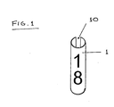
- a suitable zone marker 1 comprising a plastic tube having a longitudinal slit 10 to allow easy fitting and removal from a racecourse running rail, the outer surface of the tube displaying a clearly visible number.
- a protocol is followed for the general sectioning of the racecourse. Areas of high variability in terms of conductivity, as identified by the soil conductivity map, are considered to require going zones 40m long. Corners are also considered to require 40m long zones. Areas of intermediate change in conductivity are allocated 60m long zones, and areas of minimal change are allocated 70-80m long zones. If areas containing anomalies have been identified the spacing of the zone markers is adjusted such that the anomaly will fall fully within one going zone. Having decided upon the desired spacing, and after collaboration with the Clerk of the Course, the first zone marker (marked with the number one) is placed at a distance from an end of the racecourse corresponding to half the allocated first zone length, such that the marker is located at least substantially in what will be the centre of the first zone (ie.
- the first marker is placed 40m from the end of the racecourse). Distances may be measured using a trundle wheel. Generally, up to 140 markers may be used on a large course, with as little as 70 at a smaller venue.
- the markers are clipped on to the running rail, which marks the boundary of the racecourse, at approximately half the full height of the running rail. This allows easy identification of the markers, and facilitates correct repositioning of the markers should running rail be changed.
- the position of each marker is geo-referenced so as to obtain a complete set of geo-referenced going points from which a map accurately showing going zones can subsequently be constructed. Having geo-referenced the zone markers the positions of all starts finishes and furlong markers are also geo-referenced such that a full representation of the course can be provided.
- the same equipment used for producing the soil variability mapping is used for marker geo-referencing.
- the software used is preferably FarmWorks Site Mate sold by CTN Data Service Inc., 6795S, State Road 1, Hamilton, IN 46742-0250 USA (tel. 1-800-225-2848), although Starpal Software sold by Starpal Inc., 2531 Wapiti Road, Fort Collins, CO 80525 USA or any other suitable software package may also be used for this operation.
- the GPS receiver is started. This may be either a CSi GBX receiver as described in GB 0106531.7, or any other suitably accurate GPS system such as any Trimble GPS receivers sold by Trimble Navigation Europe Ltd., Trimble House, Meridian Office Park, Osborn Way, Hook, Hampshire, England tel. 01256 746200) the Encore M12 marketed by Motorola GPS Products, c/o BFI Optilas GmBH, Lilienthalstr, 14, D-85391, Neufahrn, Germany (www.encore.motorla.com), and the Ashtech G12 sold by Ashtech, 117 Okifer road, Sunnyvale, CA94086, USA (tel. 408-524-1400, fax 408-524-1500).
- any Trimble GPS receivers sold by Trimble Navigation Europe Ltd., Trimble House, Meridian Office Park, Osborn Way, Hook, Hampshire, England tel. 01256 746200
- the Encore M12 marketed by Motorola GPS Products, c/o BFI Optilas GmBH, Lilienthal
- Site Mate is then started. This is preferably run on a Husky HPC sold by Handheld Systems Ltd., 4300 N E Fremont, Suite 250, Portland, Oregon, 97213 (tel 503-282-2857, fax 503-281-7827) mounted on the rough terrain vehicle but any win9x/NT laptop may be used.
- the Site Mate default screen is opened and scouting (GPS integration and movement logging) is started, by using the file pull down and selecting open scouting, enabling a history of the GPS data stream to be written to file.
- the software must then be set up to allow point data referencing. This is achieved by setting the data type to point type and manual logging, after which the start (Action) button is clicked. Thereafter, activating the log button will cause the software to record the point and assign it an arbitrary value, usually starting with 1 and ending with the last logged point. Once a point has been logged, a marker will appear indicating that the point has been referenced. This allows re-navigation back to the point should it be necessary.
- a new file is preferably opened for recording the positions of the furlong markers and an additional file is then used to record the position of the starts and finishes when switching to referencing start and finish markers, such that all going points are saved under one file, the positions of all furlong markers are saved under another file, and so on.
- the use of one file is possible, but creates confusion by including superfluous information in some maps.
- the use of separate files, by comparison, allows the user to readily select the information to be displayed on any map.
- the map is constructed, using the geographical software, by processing the geo-reference data obtained on-site.
- the boundaries of the racecourse are constructed from the boundary data obtained in the conductivity survey.
- the going point data can then be processed to construct and display zones equidistant about each referenced point, such that if one hundred going points were referenced at the racecourse site, one hundred zones would be displayed, each in their correct position around the course.
- the start and finish points and furlong markers can be displayed in their correct positions.
- each set of data (going point data, boundary data, start and finish data) is preferably kept separate, allowing the user to select which sets will be displayed.
- the map is converted to a vector based image for high resolution presentation on electronic media, TV and/or paper.
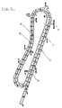
- FIG. 2 a base map of Haydock Park racecourse is shown.
- the racecourse 2 is displayed sectioned into going zones 3, as described above, each zone being numbered according to the corresponding zone marker on the racecourse itself.
- the locations of the finishing point 6 and furlong markers 7 are also displayed.
- the inner course 4 represents the Hurdle and Chase course, whereas the outer course 5 represents the flat course. Neither course has been sectioned across its width, with the exception of the run in from the number six furlong marker on the flat course. This is because this part of the racecourse has been identified as an area of change, where advantages may be gained from the particular draw of the horses, the draw being the starting stalls allocated to the horses.
- FIG. 3 a base map of Goodwood racecourse, where there is only a flat racing course, is shown. Again the locations of the zones 3, finish point 6 and furlong markers 7 on the racecourse 2 are displayed. As this racecourse is known to be variable across its width the entire length of the course has been sectioned widthways.
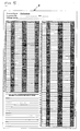
- Figure 5 shows a manual submission sheet 8 suitable for faxing that can be used to transmit the data.
- Figure 6 an HTML format submission sheet 9 located on a web page could be used.
- Other options include the Clerk providing the information verbally over the phone.
- the going information received from the Clerk is then used to create a going map for the course, by assigning to each zone on the map the going attributed by the Clerk to the corresponding zone on the racecourse. For example, if a racecourse containing one hundred going points were assessed, the going being reported as "Good” at point one and changing at or near point thirty five to "Good to Firm", a going map of the course would display the section of the course covered by zones one to thirty four as “Good” and by Zones thirty five to one hundred as “Good to Firm”, resulting in an official going of "Good to firm, Good in Places”.
- each zone may differ in size, when the zones are created, the area of each zone is recorded allowing the percentage coverage of each going to be rapidly calculated at the time of the report.
- the method of the present invention has been described above in use with traditional methods of going assessment in mind, the method may equally be used with any method of assessing going, be it quantitative or qualitative.
- FIG. 4 a second map of Goodwood racecourse is shown, with going along the racecourse now displayed according to a hatching code. As before, the finishing point 6 and furlong markers 7 are displayed. However, the divisions between zones are no longer displayed, in order to simplify the display for easier reading.
- Going maps are preferably produced in three main formats:
- the Fax map contains:
- the email map contains all of the above, except that a colour map is produced instead of a black and white copy.
- the Internet page contains all of the attributes indicated in the email copy, laid out for internet presentation in HTML format with relevant site menus.
- the colour key used for displaying going in colour going maps is as follows:
- Suitable methods of hatching are used for the display of black and white maps.
- Faxed reports are printed direct to fax from a PC.
- Email reports comprise a short note and an image of the colour going report attached.
- Internet presentation is structured for each course on the website used.
- An archive of past going reports is maintained for internet presentation. A selected number of past reports can be made available without request, with the remainder available by request only. This information is stored in a database along with all other necessary course information.
Landscapes
- Life Sciences & Earth Sciences (AREA)
- Geophysics (AREA)
- Engineering & Computer Science (AREA)
- Geology (AREA)
- Remote Sensing (AREA)
- Physics & Mathematics (AREA)
- General Life Sciences & Earth Sciences (AREA)
- Environmental & Geological Engineering (AREA)
- General Physics & Mathematics (AREA)
- Crystals, And After-Treatments Of Crystals (AREA)
- Instructional Devices (AREA)
- Management, Administration, Business Operations System, And Electronic Commerce (AREA)
- Diaphragms For Electromechanical Transducers (AREA)
- Discharge Heating (AREA)
- Analysing Materials By The Use Of Radiation (AREA)
- Radar Systems Or Details Thereof (AREA)
- Investigating Or Analyzing Materials By The Use Of Electric Means (AREA)
Applications Claiming Priority (2)
| Application Number | Priority Date | Filing Date | Title |
|---|---|---|---|
| GB0110686 | 2001-05-01 | ||
| GBGB0110686.3A GB0110686D0 (en) | 2001-05-01 | 2001-05-01 | Method of mapping going |
Publications (3)
| Publication Number | Publication Date |
|---|---|
| EP1255127A2 true EP1255127A2 (de) | 2002-11-06 |
| EP1255127A3 EP1255127A3 (de) | 2004-07-14 |
| EP1255127B1 EP1255127B1 (de) | 2008-07-09 |
Family
ID=9913831
Family Applications (1)
| Application Number | Title | Priority Date | Filing Date |
|---|---|---|---|
| EP02252900A Expired - Lifetime EP1255127B1 (de) | 2001-05-01 | 2002-04-24 | Verfahren zum Abbilden der Gehbedingungen einer Rennstrecke |
Country Status (5)
| Country | Link |
|---|---|
| US (1) | US6699042B2 (de) |
| EP (1) | EP1255127B1 (de) |
| AT (1) | ATE400827T1 (de) |
| DE (1) | DE60227445D1 (de) |
| GB (1) | GB0110686D0 (de) |
Families Citing this family (76)
| Publication number | Priority date | Publication date | Assignee | Title |
|---|---|---|---|---|
| US20060106539A1 (en) * | 2004-11-12 | 2006-05-18 | Choate Paul H | System and method for electronically recording task-specific and location-specific information, including farm-related information |
| WO2013177577A2 (en) | 2012-05-25 | 2013-11-28 | Eberle Michael J | Optical fiber pressure sensor |
| US12288233B2 (en) | 2016-04-01 | 2025-04-29 | OneTrust, LLC | Data processing systems and methods for integrating privacy information management systems with data loss prevention tools or other tools for privacy design |
| US10846433B2 (en) | 2016-06-10 | 2020-11-24 | OneTrust, LLC | Data processing consent management systems and related methods |
| US11188862B2 (en) | 2016-06-10 | 2021-11-30 | OneTrust, LLC | Privacy management systems and methods |
| US11227247B2 (en) | 2016-06-10 | 2022-01-18 | OneTrust, LLC | Data processing systems and methods for bundled privacy policies |
| US11416798B2 (en) | 2016-06-10 | 2022-08-16 | OneTrust, LLC | Data processing systems and methods for providing training in a vendor procurement process |
| US10909488B2 (en) | 2016-06-10 | 2021-02-02 | OneTrust, LLC | Data processing systems for assessing readiness for responding to privacy-related incidents |
| US12136055B2 (en) | 2016-06-10 | 2024-11-05 | OneTrust, LLC | Data processing systems for identifying, assessing, and remediating data processing risks using data modeling techniques |
| US11134086B2 (en) | 2016-06-10 | 2021-09-28 | OneTrust, LLC | Consent conversion optimization systems and related methods |
| US11675929B2 (en) | 2016-06-10 | 2023-06-13 | OneTrust, LLC | Data processing consent sharing systems and related methods |
| US10949565B2 (en) | 2016-06-10 | 2021-03-16 | OneTrust, LLC | Data processing systems for generating and populating a data inventory |
| US11416589B2 (en) | 2016-06-10 | 2022-08-16 | OneTrust, LLC | Data processing and scanning systems for assessing vendor risk |
| US11188615B2 (en) | 2016-06-10 | 2021-11-30 | OneTrust, LLC | Data processing consent capture systems and related methods |
| US10769301B2 (en) | 2016-06-10 | 2020-09-08 | OneTrust, LLC | Data processing systems for webform crawling to map processing activities and related methods |
| US10997318B2 (en) | 2016-06-10 | 2021-05-04 | OneTrust, LLC | Data processing systems for generating and populating a data inventory for processing data access requests |
| US11416590B2 (en) | 2016-06-10 | 2022-08-16 | OneTrust, LLC | Data processing and scanning systems for assessing vendor risk |
| US10284604B2 (en) | 2016-06-10 | 2019-05-07 | OneTrust, LLC | Data processing and scanning systems for generating and populating a data inventory |
| US12045266B2 (en) | 2016-06-10 | 2024-07-23 | OneTrust, LLC | Data processing systems for generating and populating a data inventory |
| US10909265B2 (en) | 2016-06-10 | 2021-02-02 | OneTrust, LLC | Application privacy scanning systems and related methods |
| US10678945B2 (en) | 2016-06-10 | 2020-06-09 | OneTrust, LLC | Consent receipt management systems and related methods |
| US11341447B2 (en) | 2016-06-10 | 2022-05-24 | OneTrust, LLC | Privacy management systems and methods |
| US12299065B2 (en) | 2016-06-10 | 2025-05-13 | OneTrust, LLC | Data processing systems and methods for dynamically determining data processing consent configurations |
| US11354434B2 (en) | 2016-06-10 | 2022-06-07 | OneTrust, LLC | Data processing systems for verification of consent and notice processing and related methods |
| US11410106B2 (en) | 2016-06-10 | 2022-08-09 | OneTrust, LLC | Privacy management systems and methods |
| US11586700B2 (en) | 2016-06-10 | 2023-02-21 | OneTrust, LLC | Data processing systems and methods for automatically blocking the use of tracking tools |
| US11727141B2 (en) | 2016-06-10 | 2023-08-15 | OneTrust, LLC | Data processing systems and methods for synching privacy-related user consent across multiple computing devices |
| US11222142B2 (en) | 2016-06-10 | 2022-01-11 | OneTrust, LLC | Data processing systems for validating authorization for personal data collection, storage, and processing |
| US11418492B2 (en) | 2016-06-10 | 2022-08-16 | OneTrust, LLC | Data processing systems and methods for using a data model to select a target data asset in a data migration |
| US11416109B2 (en) | 2016-06-10 | 2022-08-16 | OneTrust, LLC | Automated data processing systems and methods for automatically processing data subject access requests using a chatbot |
| US12118121B2 (en) | 2016-06-10 | 2024-10-15 | OneTrust, LLC | Data subject access request processing systems and related methods |
| US11481710B2 (en) | 2016-06-10 | 2022-10-25 | OneTrust, LLC | Privacy management systems and methods |
| US11544667B2 (en) | 2016-06-10 | 2023-01-03 | OneTrust, LLC | Data processing systems for generating and populating a data inventory |
| US11520928B2 (en) | 2016-06-10 | 2022-12-06 | OneTrust, LLC | Data processing systems for generating personal data receipts and related methods |
| US11475136B2 (en) | 2016-06-10 | 2022-10-18 | OneTrust, LLC | Data processing systems for data transfer risk identification and related methods |
| US11461500B2 (en) | 2016-06-10 | 2022-10-04 | OneTrust, LLC | Data processing systems for cookie compliance testing with website scanning and related methods |
| US11438386B2 (en) * | 2016-06-10 | 2022-09-06 | OneTrust, LLC | Data processing systems for data-transfer risk identification, cross-border visualization generation, and related methods |
| US11366786B2 (en) | 2016-06-10 | 2022-06-21 | OneTrust, LLC | Data processing systems for processing data subject access requests |
| US11651106B2 (en) | 2016-06-10 | 2023-05-16 | OneTrust, LLC | Data processing systems for fulfilling data subject access requests and related methods |
| US11354435B2 (en) | 2016-06-10 | 2022-06-07 | OneTrust, LLC | Data processing systems for data testing to confirm data deletion and related methods |
| US11651104B2 (en) | 2016-06-10 | 2023-05-16 | OneTrust, LLC | Consent receipt management systems and related methods |
| US10318761B2 (en) | 2016-06-10 | 2019-06-11 | OneTrust, LLC | Data processing systems and methods for auditing data request compliance |
| US11392720B2 (en) | 2016-06-10 | 2022-07-19 | OneTrust, LLC | Data processing systems for verification of consent and notice processing and related methods |
| US10685140B2 (en) | 2016-06-10 | 2020-06-16 | OneTrust, LLC | Consent receipt management systems and related methods |
| US11222139B2 (en) | 2016-06-10 | 2022-01-11 | OneTrust, LLC | Data processing systems and methods for automatic discovery and assessment of mobile software development kits |
| US11403377B2 (en) | 2016-06-10 | 2022-08-02 | OneTrust, LLC | Privacy management systems and methods |
| US11295316B2 (en) | 2016-06-10 | 2022-04-05 | OneTrust, LLC | Data processing systems for identity validation for consumer rights requests and related methods |
| US11625502B2 (en) | 2016-06-10 | 2023-04-11 | OneTrust, LLC | Data processing systems for identifying and modifying processes that are subject to data subject access requests |
| US12591828B2 (en) | 2016-06-10 | 2026-03-31 | OneTrust, LLC | Data processing systems for fulfilling data subject access requests and related methods |
| US11366909B2 (en) | 2016-06-10 | 2022-06-21 | OneTrust, LLC | Data processing and scanning systems for assessing vendor risk |
| US12381915B2 (en) | 2016-06-10 | 2025-08-05 | OneTrust, LLC | Data processing systems and methods for performing assessments and monitoring of new versions of computer code for compliance |
| US10740487B2 (en) | 2016-06-10 | 2020-08-11 | OneTrust, LLC | Data processing systems and methods for populating and maintaining a centralized database of personal data |
| US11636171B2 (en) | 2016-06-10 | 2023-04-25 | OneTrust, LLC | Data processing user interface monitoring systems and related methods |
| US12052289B2 (en) | 2016-06-10 | 2024-07-30 | OneTrust, LLC | Data processing systems for data-transfer risk identification, cross-border visualization generation, and related methods |
| US11294939B2 (en) | 2016-06-10 | 2022-04-05 | OneTrust, LLC | Data processing systems and methods for automatically detecting and documenting privacy-related aspects of computer software |
| US11562097B2 (en) | 2016-06-10 | 2023-01-24 | OneTrust, LLC | Data processing systems for central consent repository and related methods |
| US10013577B1 (en) | 2017-06-16 | 2018-07-03 | OneTrust, LLC | Data processing systems for identifying whether cookies contain personally identifying information |
| US11544409B2 (en) | 2018-09-07 | 2023-01-03 | OneTrust, LLC | Data processing systems and methods for automatically protecting sensitive data within privacy management systems |
| US10803202B2 (en) | 2018-09-07 | 2020-10-13 | OneTrust, LLC | Data processing systems for orphaned data identification and deletion and related methods |
| EP4179435B1 (de) | 2020-07-08 | 2024-09-04 | OneTrust LLC | Systeme und verfahren zur gezielten datenerfassung |
| ES3055164T3 (en) | 2020-07-28 | 2026-02-10 | Onetrust Llc | Systems and methods for automatically blocking the use of tracking tools |
| US20230289376A1 (en) | 2020-08-06 | 2023-09-14 | OneTrust, LLC | Data processing systems and methods for automatically redacting unstructured data from a data subject access request |
| US11436373B2 (en) | 2020-09-15 | 2022-09-06 | OneTrust, LLC | Data processing systems and methods for detecting tools for the automatic blocking of consent requests |
| US11526624B2 (en) | 2020-09-21 | 2022-12-13 | OneTrust, LLC | Data processing systems and methods for automatically detecting target data transfers and target data processing |
| US12265896B2 (en) | 2020-10-05 | 2025-04-01 | OneTrust, LLC | Systems and methods for detecting prejudice bias in machine-learning models |
| EP4241173A1 (de) | 2020-11-06 | 2023-09-13 | OneTrust LLC | Systeme und verfahren zur identifizierung von datenverarbeitungsaktivitäten auf der basis von datenentdeckungsergebnissen |
| WO2022159901A1 (en) | 2021-01-25 | 2022-07-28 | OneTrust, LLC | Systems and methods for discovery, classification, and indexing of data in a native computing system |
| US11442906B2 (en) | 2021-02-04 | 2022-09-13 | OneTrust, LLC | Managing custom attributes for domain objects defined within microservices |
| US11494515B2 (en) | 2021-02-08 | 2022-11-08 | OneTrust, LLC | Data processing systems and methods for anonymizing data samples in classification analysis |
| US12641108B2 (en) | 2021-02-10 | 2026-05-26 | OneTrust, LLC | Systems and methods for mitigating risks of third-party computing system functionality integration into a first-party computing system |
| US11775348B2 (en) | 2021-02-17 | 2023-10-03 | OneTrust, LLC | Managing custom workflows for domain objects defined within microservices |
| US11546661B2 (en) | 2021-02-18 | 2023-01-03 | OneTrust, LLC | Selective redaction of media content |
| US12671693B2 (en) | 2021-03-08 | 2026-06-30 | One Trust, LLC | Data transfer discovery and analysis systems and related methods |
| US11562078B2 (en) | 2021-04-16 | 2023-01-24 | OneTrust, LLC | Assessing and managing computational risk involved with integrating third party computing functionality within a computing system |
| US12153704B2 (en) | 2021-08-05 | 2024-11-26 | OneTrust, LLC | Computing platform for facilitating data exchange among computing environments |
| US11620142B1 (en) | 2022-06-03 | 2023-04-04 | OneTrust, LLC | Generating and customizing user interfaces for demonstrating functions of interactive user environments |
Family Cites Families (9)
| Publication number | Priority date | Publication date | Assignee | Title |
|---|---|---|---|---|
| US5442293A (en) * | 1992-12-21 | 1995-08-15 | Lange; James N. | Method and apparatus for determining fluid content and conductivity in porous materials |
| US6236907B1 (en) * | 1995-05-30 | 2001-05-22 | Ag-Chem Equipment Co., Inc. | System and method for creating agricultural decision and application maps for automated agricultural machines |
| US5902343A (en) * | 1996-11-22 | 1999-05-11 | Case Corporation | Automatic scaling of GPS field maps |
| US5825188A (en) * | 1996-11-27 | 1998-10-20 | Montgomery; Jerry R. | Method of mapping and monitoring groundwater and subsurface aqueous systems |
| US5841282A (en) * | 1997-02-10 | 1998-11-24 | Christy; Colin | Device for measuring soil conductivity |
| NL1007487C2 (nl) * | 1997-11-07 | 1999-05-10 | Maasland Nv | Middelen voor het regelen van een aangedreven grondbewerkingsmachine op basis van informatie ontleend aan een landkaart. |
| US6041582A (en) * | 1998-02-20 | 2000-03-28 | Case Corporation | System for recording soil conditions |
| US6199000B1 (en) * | 1998-07-15 | 2001-03-06 | Trimble Navigation Limited | Methods and apparatus for precision agriculture operations utilizing real time kinematic global positioning system systems |
| GB2340243A (en) * | 1998-07-30 | 2000-02-16 | P Shaw | Trailer apparatus for measuring ground density |
-
2001
- 2001-05-01 GB GBGB0110686.3A patent/GB0110686D0/en not_active Ceased
-
2002
- 2002-04-24 AT AT02252900T patent/ATE400827T1/de not_active IP Right Cessation
- 2002-04-24 EP EP02252900A patent/EP1255127B1/de not_active Expired - Lifetime
- 2002-04-24 DE DE60227445T patent/DE60227445D1/de not_active Expired - Fee Related
- 2002-04-25 US US10/131,908 patent/US6699042B2/en not_active Expired - Fee Related
Also Published As
| Publication number | Publication date |
|---|---|
| US20030001855A1 (en) | 2003-01-02 |
| EP1255127B1 (de) | 2008-07-09 |
| EP1255127A3 (de) | 2004-07-14 |
| DE60227445D1 (de) | 2008-08-21 |
| GB0110686D0 (en) | 2001-06-20 |
| US6699042B2 (en) | 2004-03-02 |
| ATE400827T1 (de) | 2008-07-15 |
Similar Documents
| Publication | Publication Date | Title |
|---|---|---|
| EP1255127B1 (de) | Verfahren zum Abbilden der Gehbedingungen einer Rennstrecke | |
| US8270666B2 (en) | Searchable electronic records of underground facility locate marking operations | |
| US6498982B2 (en) | Methods and apparatus for displaying a travel route and/or generating a list of places of interest located near the travel route | |
| US20140321717A1 (en) | Electronic manifest of underground facility locate marks | |
| EP1241488A2 (de) | Anlage und Verfahren zum Analysieren und Vermessen von Böden und Geländen | |
| DE102010050888A1 (de) | Systeme und Verfahren zur Ermittlung von Positionen von unterirdischen Gegenständen | |
| US9280269B2 (en) | Electronic manifest of underground facility locate marks | |
| AU2009213151B2 (en) | Searchable electronic records of underground facility locate marking operations | |
| AU2003200205B2 (en) | Method of mapping going conditions for a racecourse | |
| HK1049703A (en) | Method of mapping going conditions for a race course | |
| JP3728433B2 (ja) | ケーブル位置情報管理システム及びケーブル位置情報管理方法並びにケーブル位置情報管理プログラム | |
| AU2003200202A1 (en) | Apparatus and method for analysing and mapping soil land terrain | |
| US7047134B2 (en) | Method of selecting a soil stabilization protocol for a construction site | |
| KR20220166015A (ko) | 딥러닝 기반 항공 영상 내 포트홀 탐지 결과 시각화 장치 및 그 방법 | |
| Pariseault et al. | Determining Layer Thickness and Understanding Moisture Related Damage of State-Owned Roads Using GPR and Capturing Such in a GIS-Based Inventory | |
| CN218159025U (zh) | 一种地下管线分布采集装置 | |
| JP2023151235A (ja) | 評価単位確定装置及び相続税財産評価システム | |
| Guttormsen et al. | GIS, GPS, county uses, concerns and considerations | |
| Bilodeau et al. | Operational integration of GPS into forest management activities which use a GIS monitor forest operation | |
| AU2012241082B2 (en) | Searchable electronic records of underground facility locate marking operations | |
| JPH10307534A (ja) | 衛星画像提供システム | |
| JP2008292923A (ja) | 地形図作成システム | |
| Bryan | Application of ERTS-1 and multiplexed SLAR imagery for the study of flooded shorelines |
Legal Events
| Date | Code | Title | Description |
|---|---|---|---|
| PUAI | Public reference made under article 153(3) epc to a published international application that has entered the european phase |
Free format text: ORIGINAL CODE: 0009012 |
|
| AK | Designated contracting states |
Kind code of ref document: A2 Designated state(s): AT BE CH CY DE DK ES FI FR GB GR IE IT LI LU MC NL PT SE TR |
|
| AX | Request for extension of the european patent |
Free format text: AL;LT;LV;MK;RO;SI |
|
| PUAL | Search report despatched |
Free format text: ORIGINAL CODE: 0009013 |
|
| AK | Designated contracting states |
Kind code of ref document: A3 Designated state(s): AT BE CH CY DE DK ES FI FR GB GR IE IT LI LU MC NL PT SE TR |
|
| AX | Request for extension of the european patent |
Extension state: AL LT LV MK RO SI |
|
| RIC1 | Information provided on ipc code assigned before grant |
Ipc: 7A 01B 79/00 B Ipc: 7G 01V 3/15 A |
|
| 17P | Request for examination filed |
Effective date: 20050110 |
|
| AKX | Designation fees paid |
Designated state(s): AT BE CH CY DE DK ES FI FR GB GR IE IT LI LU MC NL PT SE TR |
|
| 17Q | First examination report despatched |
Effective date: 20070723 |
|
| APBN | Date of receipt of notice of appeal recorded |
Free format text: ORIGINAL CODE: EPIDOSNNOA2E |
|
| APBR | Date of receipt of statement of grounds of appeal recorded |
Free format text: ORIGINAL CODE: EPIDOSNNOA3E |
|
| APBV | Interlocutory revision of appeal recorded |
Free format text: ORIGINAL CODE: EPIDOSNIRAPE |
|
| GRAP | Despatch of communication of intention to grant a patent |
Free format text: ORIGINAL CODE: EPIDOSNIGR1 |
|
| RIN1 | Information on inventor provided before grant (corrected) |
Inventor name: SMITH, JOHN JUSTIN,WILSTEAD HILL COTTAGE Inventor name: PETERS, MARTIN |
|
| GRAS | Grant fee paid |
Free format text: ORIGINAL CODE: EPIDOSNIGR3 |
|
| GRAA | (expected) grant |
Free format text: ORIGINAL CODE: 0009210 |
|
| AK | Designated contracting states |
Kind code of ref document: B1 Designated state(s): AT BE CH CY DE DK ES FI FR GB GR IE IT LI LU MC NL PT SE TR |
|
| REG | Reference to a national code |
Ref country code: GB Ref legal event code: FG4D |
|
| REG | Reference to a national code |
Ref country code: CH Ref legal event code: EP |
|
| REF | Corresponds to: |
Ref document number: 60227445 Country of ref document: DE Date of ref document: 20080821 Kind code of ref document: P |
|
| REG | Reference to a national code |
Ref country code: IE Ref legal event code: FG4D |
|
| NLV1 | Nl: lapsed or annulled due to failure to fulfill the requirements of art. 29p and 29m of the patents act | ||
| PG25 | Lapsed in a contracting state [announced via postgrant information from national office to epo] |
Ref country code: PT Free format text: LAPSE BECAUSE OF FAILURE TO SUBMIT A TRANSLATION OF THE DESCRIPTION OR TO PAY THE FEE WITHIN THE PRESCRIBED TIME-LIMIT Effective date: 20081209 Ref country code: ES Free format text: LAPSE BECAUSE OF FAILURE TO SUBMIT A TRANSLATION OF THE DESCRIPTION OR TO PAY THE FEE WITHIN THE PRESCRIBED TIME-LIMIT Effective date: 20081020 Ref country code: NL Free format text: LAPSE BECAUSE OF FAILURE TO SUBMIT A TRANSLATION OF THE DESCRIPTION OR TO PAY THE FEE WITHIN THE PRESCRIBED TIME-LIMIT Effective date: 20080709 |
|
| PG25 | Lapsed in a contracting state [announced via postgrant information from national office to epo] |
Ref country code: AT Free format text: LAPSE BECAUSE OF FAILURE TO SUBMIT A TRANSLATION OF THE DESCRIPTION OR TO PAY THE FEE WITHIN THE PRESCRIBED TIME-LIMIT Effective date: 20080709 Ref country code: FI Free format text: LAPSE BECAUSE OF FAILURE TO SUBMIT A TRANSLATION OF THE DESCRIPTION OR TO PAY THE FEE WITHIN THE PRESCRIBED TIME-LIMIT Effective date: 20080709 |
|
| PG25 | Lapsed in a contracting state [announced via postgrant information from national office to epo] |
Ref country code: BE Free format text: LAPSE BECAUSE OF FAILURE TO SUBMIT A TRANSLATION OF THE DESCRIPTION OR TO PAY THE FEE WITHIN THE PRESCRIBED TIME-LIMIT Effective date: 20080709 |
|
| PG25 | Lapsed in a contracting state [announced via postgrant information from national office to epo] |
Ref country code: DK Free format text: LAPSE BECAUSE OF FAILURE TO SUBMIT A TRANSLATION OF THE DESCRIPTION OR TO PAY THE FEE WITHIN THE PRESCRIBED TIME-LIMIT Effective date: 20080709 |
|
| PLBE | No opposition filed within time limit |
Free format text: ORIGINAL CODE: 0009261 |
|
| STAA | Information on the status of an ep patent application or granted ep patent |
Free format text: STATUS: NO OPPOSITION FILED WITHIN TIME LIMIT |
|
| 26N | No opposition filed |
Effective date: 20090414 |
|
| PG25 | Lapsed in a contracting state [announced via postgrant information from national office to epo] |
Ref country code: IT Free format text: LAPSE BECAUSE OF FAILURE TO SUBMIT A TRANSLATION OF THE DESCRIPTION OR TO PAY THE FEE WITHIN THE PRESCRIBED TIME-LIMIT Effective date: 20080709 |
|
| REG | Reference to a national code |
Ref country code: CH Ref legal event code: PL |
|
| REG | Reference to a national code |
Ref country code: HK Ref legal event code: WD Ref document number: 1049703 Country of ref document: HK |
|
| GBPC | Gb: european patent ceased through non-payment of renewal fee |
Effective date: 20090424 |
|
| REG | Reference to a national code |
Ref country code: FR Ref legal event code: ST Effective date: 20091231 |
|
| PG25 | Lapsed in a contracting state [announced via postgrant information from national office to epo] |
Ref country code: CH Free format text: LAPSE BECAUSE OF NON-PAYMENT OF DUE FEES Effective date: 20090430 Ref country code: SE Free format text: LAPSE BECAUSE OF FAILURE TO SUBMIT A TRANSLATION OF THE DESCRIPTION OR TO PAY THE FEE WITHIN THE PRESCRIBED TIME-LIMIT Effective date: 20081009 Ref country code: LI Free format text: LAPSE BECAUSE OF NON-PAYMENT OF DUE FEES Effective date: 20090430 Ref country code: DE Free format text: LAPSE BECAUSE OF NON-PAYMENT OF DUE FEES Effective date: 20091103 |
|
| PG25 | Lapsed in a contracting state [announced via postgrant information from national office to epo] |
Ref country code: MC Free format text: LAPSE BECAUSE OF NON-PAYMENT OF DUE FEES Effective date: 20090430 Ref country code: IE Free format text: LAPSE BECAUSE OF NON-PAYMENT OF DUE FEES Effective date: 20090424 Ref country code: GB Free format text: LAPSE BECAUSE OF NON-PAYMENT OF DUE FEES Effective date: 20090424 Ref country code: FR Free format text: LAPSE BECAUSE OF NON-PAYMENT OF DUE FEES Effective date: 20091222 |
|
| PG25 | Lapsed in a contracting state [announced via postgrant information from national office to epo] |
Ref country code: GR Free format text: LAPSE BECAUSE OF FAILURE TO SUBMIT A TRANSLATION OF THE DESCRIPTION OR TO PAY THE FEE WITHIN THE PRESCRIBED TIME-LIMIT Effective date: 20081010 |
|
| PG25 | Lapsed in a contracting state [announced via postgrant information from national office to epo] |
Ref country code: LU Free format text: LAPSE BECAUSE OF NON-PAYMENT OF DUE FEES Effective date: 20090424 |
|
| PG25 | Lapsed in a contracting state [announced via postgrant information from national office to epo] |
Ref country code: TR Free format text: LAPSE BECAUSE OF FAILURE TO SUBMIT A TRANSLATION OF THE DESCRIPTION OR TO PAY THE FEE WITHIN THE PRESCRIBED TIME-LIMIT Effective date: 20080709 |
|
| PG25 | Lapsed in a contracting state [announced via postgrant information from national office to epo] |
Ref country code: CY Free format text: LAPSE BECAUSE OF FAILURE TO SUBMIT A TRANSLATION OF THE DESCRIPTION OR TO PAY THE FEE WITHIN THE PRESCRIBED TIME-LIMIT Effective date: 20080709 |