EP1300656A1 - System und Verfahren der Kommunikation für ein Navigationssystem, Übertragunsvorrichtung zur Routenführung und Anschlusseinheit - Google Patents
System und Verfahren der Kommunikation für ein Navigationssystem, Übertragunsvorrichtung zur Routenführung und Anschlusseinheit Download PDFInfo
- Publication number
- EP1300656A1 EP1300656A1 EP02256982A EP02256982A EP1300656A1 EP 1300656 A1 EP1300656 A1 EP 1300656A1 EP 02256982 A EP02256982 A EP 02256982A EP 02256982 A EP02256982 A EP 02256982A EP 1300656 A1 EP1300656 A1 EP 1300656A1
- Authority
- EP
- European Patent Office
- Prior art keywords
- server
- information
- navigation
- procedure
- terminal
- Prior art date
- Legal status (The legal status is an assumption and is not a legal conclusion. Google has not performed a legal analysis and makes no representation as to the accuracy of the status listed.)
- Withdrawn
Links
Images


Classifications
-
- G—PHYSICS
- G01—MEASURING; TESTING
- G01C—MEASURING DISTANCES, LEVELS OR BEARINGS; SURVEYING; NAVIGATION; GYROSCOPIC INSTRUMENTS; PHOTOGRAMMETRY OR VIDEOGRAMMETRY
- G01C21/00—Navigation; Navigational instruments not provided for in groups G01C1/00 - G01C19/00
- G01C21/26—Navigation; Navigational instruments not provided for in groups G01C1/00 - G01C19/00 specially adapted for navigation in a road network
- G01C21/34—Route searching; Route guidance
-
- G—PHYSICS
- G08—SIGNALLING
- G08G—TRAFFIC CONTROL SYSTEMS
- G08G1/00—Traffic control systems for road vehicles
- G08G1/09—Arrangements for giving variable traffic instructions
- G08G1/0962—Arrangements for giving variable traffic instructions having an indicator mounted inside the vehicle, e.g. giving voice messages
- G08G1/0968—Systems involving transmission of navigation instructions to the vehicle
- G08G1/0969—Systems involving transmission of navigation instructions to the vehicle having a display in the form of a map
Definitions
- the present invention relates to communication navigation systems and methods, etc. for performing navigation by transmitting map data to navigation terminals via a communication network. More particularly, the invention is directed to a communication navigation system and method, etc. which can present the latest information with navigation terminals.
- navigation terminals such as in-vehicle navigation units, portable navigation units, PDAs (Personal Digital Assistants) and cellular telephones, according to their request.
- navigation terminals present a user with predetermined information visibly and audibly, based on position data detected by a GPS (Global Positioning System) receiver mounted thereon as well as map data transmitted from the server, to guide the user to his or her destination.
- GPS Global Positioning System
- the server receiving a request for guidance to a destination from a navigation terminal disposed on a vehicle, calculates the best route, etc. for a total route from a starting point to the destination, and transmits to the navigation terminal the calculated data, etc. en bloc.
- a memory of the navigation terminal may, in some cases, be too small to receive all the calculated data, etc. transmitted from the server. In such cases, the navigation terminal cannot receive new data any longer, and hence cannot update the best route, etc. according to the latest traffic information, etc.
- the present invention provides a communication navigation method and system, etc. capable of appropriately reflecting the latest information while keeping the storage capacity of a terminal unit low.
- the above object of the present invention can be achieved by a communication navigation method for performing navigation, using map data stored in a server and current position data about a navigation terminal, by transmitting the map data to the navigation terminal via a communication network.
- the communication navigation method is provided with: a first procedure in which the navigation terminal requests the server to transmit an information segment necessary for a first current part of guidance via the communication network; a second procedure in which the server transmits to the navigation terminal the information segment requested by the first procedure, via the communication network; a third procedure in which after the second procedure, the navigation terminal requests the server to transmit an information segment necessary for a second current part of the guidance via the communication network; and a fourth procedure in which the server transmits to the navigation terminal the information segment requested by the third procedure, via the communication network.
- the information segment transmitted by the fourth procedure is an update of the information segment transmitted by the second procedure.
- the server transmits to the navigation terminal the information necessary for guidance in segments, whereby the navigation terminal, receiving the information on a segment basis, can reduce the storage capacity of its memory. Additionally, the updated information is transmitted, to allow the navigation terminal to acquire information reflecting the latest road conditions, etc.
- Each of the information segments may be route information indicative of a route.
- the best route information can be obtained based on the latest traffic conditions.
- Each of the information segments may be guidance information used for the guidance.
- the best guidance information can be obtained based on the latest traffic conditions.
- a communication navigation system of the present invention for implementing a communication navigation method for performing navigation, using map data stored in a server and current position data about a navigation terminal, by transmitting the map data to the navigation terminal via a communication network.
- the communication navigation method is provided with: a first procedure in which the navigation terminal requests the server to transmit an information segment necessary for a first current part of guidance via the communication network; a second procedure in which the server transmits to the navigation terminal the information segment requested by the first procedure, via the communication network; a third procedure in which after the second procedure, the navigation terminal requests the server to transmit an information segment necessary for a second current part of the guidance via the communication network; and a fourth procedure in which the server transmits to the navigation terminal the information segment requested by the third procedure, via the communication network.
- the information segment transmitted by the fourth procedure is an update of the information segment transmitted by the second procedure.
- the server transmits to the navigation terminal the information necessary for guidance in segments, whereby the navigation terminal, receiving the information on a segment basis, can reduce the storage capacity of its memory. Additionally, the updated information is transmitted, to allow the navigation terminal to acquire information reflecting the latest road conditions, etc.
- Each of the information segments may be route information indicative of a route.
- the best route information can be obtained based on the latest traffic conditions.
- Each of the information segments may be guidance information used for the guidance.
- the best guidance information can be obtained based on the latest traffic conditions.
- a terminal unit of the present invention that implements a communication navigation method for performing navigation, using map data stored in a server and current position data about a navigation terminal, by transmitting the map data to the navigation terminal via a communication network, as the navigation terminal.
- the communication navigation method is provided with: a first procedure in which the navigation terminal requests the server to transmit an information segment necessary for a first current part of guidance via the communication network; a second procedure in which the server transmits to the navigation terminal the information segment requested by the first procedure, via the communication network; a third procedure in which after the second procedure, the navigation terminal requests the server to transmit an information segment necessary for a second current part of the guidance via the communication network; and a fourth procedure in which the server transmits to the navigation terminal the information segment requested by the third procedure, via the communication network.
- the information segment transmitted by the fourth procedure is an update of the information segment transmitted by the second procedure.
- the server transmits to the navigation terminal the information necessary for guidance in segments, whereby the navigation terminal, receiving the information on a segment basis, can reduce the storage capacity of its memory. Additionally, the updated information is transmitted, to allow the navigation terminal to acquire information reflecting the latest road conditions, etc.
- Each of the information segments may be route information indicative of a route.
- the best route information can be obtained based on the latest traffic conditions.
- Each of the information segments may be guidance information used for the guidance.
- the best guidance information can be obtained based on the latest traffic conditions.
- the preferred embodiment refers to a case where the invention is applied to a navigation system which includes terminal units mounted on vehicles, a server connected to the terminal units via a network such as the Internet, and the network, and which assists in driving the vehicles.
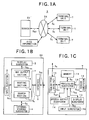
- FIGS. 1 to 4 the general configuration and operation of the navigation system according to this embodiment will be described.
- the navigation system S is provided with terminal units T, and a server SV.
- Each terminal unit T sends to the server SV a terminal signal St indicative of information such as vehicle's current position and travelling direction, as well as a request for information to be presented to a driver, and also receives from the server SV a terminal signal St indicative of various navigation process information corresponding to the request, and presents the requested information to the driver.
- the server SV Upon receipt of the terminal signal St as a server signal Ssv, the server SV searches for map information, etc.
- the terminal unit T and the server SV communicate with each other via the Internet IN.
- the server SV can obtain VICS information via the Internet.
- one sever SV is connected to a plurality of terminal units T so that the server SV can send to the terminal units T map and other information on a time division basis.
- FIGS. 1B and 1C the detailed configuration of the navigation system S will be described.
- the server SV comprises a CPU 1, a display subsystem 2, an input subsystem 3, an external storage subsystem 4 such as a hard drive, and an interface 5.
- the interface 5 appropriately interfaces an input server signal Ssv from the Internet IN to output the signal Ssv to the CPU 1 as a to-be-processed server signal Sssv, and also appropriately interfaces a processed server signal Sssv from the CPU 1 to output the signal Sssv to a terminal unit T as a server signal Ssv via the Internet IN.
- the external storage subsystem 4 stores all information requisite for a navigation process performed by the navigation system S according to this embodiment, and outputs such information to the CPU 1 as a memory signal Sm, as needed.
- the information includes map information for display on each terminal unit T, various information used for a routing process (described below), point information for performing the navigation process according to this embodiment (more specifically, position information about points indicated on a map for display on the terminal unit T and descriptions of these points), and information about a user of the terminal unit T.
- the CPU 1 is provided with a map output section 1a, a routing section 1b, and a search section 1c for its processing.
- the map output section 1a searches for and reads, based on the request input as the to-be-processed server signal Sssv, map information corresponding to the request from among the map information stored in the external storage subsystem 4 as a memory signal Sm, and outputs the memory signal Sm to the terminal unit T via the interface 5 and the Internet IN as a processed server signal Sssv.
- the routing section 1b calculates and finds, based on the request input as the to-be-processed server signal Sssv, a route along which the vehicle should travel, using the map information stored in the external storage subsystem 4, searches and reads the map information including the calculated and found route as a memory signal Sm, and outputs the memory signal Sm to the terminal unit T via the interface 5 and the Internet IN as a processed server signal Sssv.
- the routing section 1b Concurrently therewith, the routing section 1b generates route guidance information for guiding the vehicle having the terminal unit T aboard to move along the searched route, and outputs the searched result to the terminal unit T via the interface 5 and the Internet IN as a processed server signal Sssv.
- the search section 1c searches for and reads, as a memory signal Sm, the point information, etc. stored in the external storage subsystem 4 based on the request input as the to-be-processed server signal Sssv, and outputs the memory signal Sm to the terminal unit T via the interface 5 and the Internet IN as a processed server signal Sssv.
- the input subsystem 3 generates, upon entry of information necessary for the above operations, an input signal Sin corresponding to the entered information, and outputs the generated input signal Sin to the CPU 1. After having received the signal Sin, the CPU 1 performs its processing accordingly.
- Information to be presented to an operator of the server SV during the above operations is output to the display subsystem 2 as a display signal Sdp so that information corresponding to the display signal Sdp is displayed on the display subsystem 2.
- a terminal unit T is provided with a processing subsystem 10 including a CPU and a memory, a memory 11, a sensor subsystem 12, a display subsystem 13, a speech output subsystem 14, a transmitter/receiver 15 such as a cellular telephone, and an input subsystem 16.
- a processing subsystem 10 including a CPU and a memory, a memory 11, a sensor subsystem 12, a display subsystem 13, a speech output subsystem 14, a transmitter/receiver 15 such as a cellular telephone, and an input subsystem 16.
- the transmitter/receiver 15 appropriately interfaces an input terminal signal St from the Internet IN to output a to-be-processed terminal signal Stt to the processing subsystem 10, and similarly interfaces a processed terminal signal Stt from the processing subsystem 10 to output a terminal signal St to the server SV via the Internet IN.
- the sensor subsystem 12 is provided with a GPS receiver, a vehicle-speed sensor, and an acceleration sensor, and outputs information indicative of the vehicle's current position and attitude, etc. from the receiver and sensors, to the processing subsystem 10 as a sensor signal Ssc.
- the GPS receiver outputs absolute position information (absolute geographical latitude and longitude data) about a vehicle carrying the terminal unit T aboard, based on position information contained in GPS radio waves from a GPS satellite in orbit.
- the vehicle-speed sensor outputs distance and speed information by computing a distance traveled and a vehicle's speed based on so-called vehicle-speed pulses from a front wheel of the vehicle.
- the acceleration sensor detects turning angles and vertical inclinations of the vehicle to output information about the vehicle's travelling direction.
- the input subsystem 16 generates, upon specification of a map for display on the display subsystem 13 or upon specification of a setting for the navigation process according to this embodiment such as a destination, an input signal Sin corresponding to the specification, and outputs the generated input signal Sin to the processing subsystem 10.
- the processing subsystem 10 Based on these signals Ssc and Sin, the processing subsystem 10 generates information including current position information about the vehicle carrying the terminal unit T aboard, as well as a request, etc. corresponding to the specification made at the input subsystem 16. Then, the processing subsystem 10 outputs such generated information, request, etc. as a to-be-processed terminal signal Stt to the server SV via the transmitter/receiver 15.
- the processing subsystem 10 Upon receipt of a processed terminal signal Stt via the Internet IN and the transmitter/receiver 15 from the server SV that has processed the to-be-processed signal Stt based on the current position information, request, etc., the processing subsystem 10 outputs the map information contained in the received processed terminal signal Stt to the display subsystem 13 as a display signal Sdp to display the map information thereon.
- the display subsystem 13 additionally displays information such as map information along the route generated by the routing section 1b within the server SV or routing information based on the route guidance information.
- audible messages to be given to the driver of the vehicle is output to the speech output subsystem 14 as an audio signal Sad, to implement the route guidance.
- the processing subsystem 10 temporarily stores some information, such as the map information sent from the server SV, in the memory 11 as a memory signal Sm, which is then read, as needed, for proper indicator light processing.
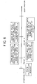
- the server SV constantly checks whether or not any terminal unit T sends a request for a map for display (step S1). If not (step S1; NO), the server SV waits. If so (step S1; YES), the server SV determines whether or not the requesting terminal unit T is authorized by the navigation system S according to this embodiment (step S2).
- the server SV Upon completion of the authorization step, the server SV causes the map output section 1a to search for appropriate map information based on the received request by referring to the map information stored in the external storage subsystem 4 (steps S3 and S4).
- the search step S4 is completed (step S4; YES)
- the searched map information is sent to the terminal unit T (step S5).
- step S6 The server SV keeps checking whether or not all of the map information has been sent (step S6). If not (step S6; NO), the server SV continues sending the rest of the information, and if so (step S6; YES), it brings the series of map search steps to an end.
- the map information is sent while divided into segments. That is, of the total route along which to guide the vehicle, only a map information segment that is immediately necessary is sent, and this is repeated multiple times until the vehicle reaches the destination. This will be detailed below.
- the server SV In the route calculation process, the server SV always checks whether or not a request containing a place of departure, a destination, and routing conditions (more specifically, whether or not highways are preferred, or calculations are to be made so that the vehicle drives along specific roads, etc.) has been sent from any terminal unit T (step S20). If not (step S20; NO), the server SV waits, and if so (step S20; YES), the server SV then determines whether or not that requesting terminal unit T is authorized by the navigation system S according to this embodiment (step S21).
- the server SV Upon completion of the authorization step, the server SV extracts and acquires user information related to a user who owns the authorized terminal unit T from the external storage subsystem 4 (step S22), and then causes its routing section 1b to perform prescribed route calculation steps based on the destination, etc. contained in the request as well as the acquired user information (steps S23 and S24).
- the server SV temporarily loads the calculated route information into the memory within the CPU 1, to terminate the route calculation process.
- the server SV may send the calculated route information to the terminal unit T so that the unit T causes its display subsystem 13 to display the received route information thereon.
- the route calculation process is carried out by dividing the route into segments. That is, of the entire route along which to guide the vehicle, route calculations are made only for a route segment that is immediately needed, and this is repeated a plurality of times until the vehicle reaches the destination. This will be further explained below.
- the server SV constantly checks whether or not the terminal unit T has sent a request for starting route guidance (step S25). If not (step S25; NO), the server SV waits, and if so (step S25; YES), it determines whether or not the requesting terminal unit T is authorized by the navigation system S according to this embodiment (step S26).
- the server SV Upon completion of the authorization step, the server SV extracts and acquires user information related to a user who owns the authorized terminal unit T from the external storage subsystem 4 for confirmation (step S27), and causes its routing section 1b to perform prescribed route guidance steps (steps S28 and S29) according to the request.
- the server SV Upon completion of the route guidance process (step S29; YES), the server SV terminates the route guidance process, which includes a step of acquiring current position information indicative of the vehicle's current position, a step of determining whether or not the acquired current position is on the previously calculated route, and a step of calculating the relationship between the vehicle's current position and a point of interest (an intersection for turn, a landmark, or the like) along the route, and sending the calculated relationship to the terminal unit T to inform the driver of the calculated relationship.
- a point of interest an intersection for turn, a landmark, or the like
- the route guidance process is carried out by dividing the guidance processing into segments. That is, of the total route along which to guide the vehicle, guidance calculations are performed only for a guidance segment that is currently necessary, and this is repeated multiple times until the vehicle reaches the destination. This will be detailed below.
- the server SV keeps checking whether or not any terminal unit T has sent a request for information to be given to the driver (step S10). If not (step S10; NO), the server SV waits. If so (step S10; YES), the server SV determines whether or not that requesting terminal unit T is authorized by the navigation system S according to this embodiment (step S11).
- the server SV Upon completion of the authorization step, the server SV then causes its search section 1c to search for appropriate information from among the information stored in the external storage subsystem 4 based on the received request (steps S12 and S13). When the search is completed (step S13; YES), the server SV sends the searched information to the terminal unit T (step S14).
- step S15 the server keeps checking whether or not all of the searched information has been sent (step S15). If not (step S15; NO), the server SV continues sending the rest of the information, and if so (step S15; YES), it brings the series of information search steps to an end.
- processing is not performed for the total route at once, but is performed by dividing the total route into segments, and only for one processing segment at a time which is immediately necessary. Referring now to FIGS. 5 and 6, such segmented processing will be described.
- FIGS. 5 and 6 are flowcharts showing the segmented processing according to this embodiment.
- the server SV requests for the map search process (FIG. 2), the rout calculation process (FIG. 3A), and the route guidance process (FIG. 3B).
- the server SV performs the series of steps shown in FIGS. 2, 3A and 3B, with the respective steps being carried out only for a segment of immediate need for travelling from the starting point.
- the server SV makes initial route calculations (FIG. 5), etc., and then sends to the terminal unit T only a route data segment and a guidance data segment which the user currently needs for driving from the starting point.
- the terminal unit T sends new requests to the server SV.
- the server SV performs the series of steps shown in FIGS. 2, 3A and 3B once again, with the processing being limited only to a segment currently necessary for travelling from the point A.
- the processing such as the route calculations takes into account the latest traffic information acquired upon passage at the point A.
- the latest traffic information is based on VICS information (FIG. 1) which the server SV has acquired via the Internet IN.
- the server SV carries out the updating route calculations (FIG. 5), etc., and sends to the terminal unit T updated route data (route calculation results) and guidance data immediately necessary for driving from the point A.
- the terminal unit T sends new requests to the server SV.
- the server SV Upon receipt of the new requests, the server SV performs the series of steps shown in FIGS. 2, 3A and 3B once again, with the processing covering only a segment of immediate need for travelling from the point B.
- the processing such as the route calculations considers the latest traffic information acquired upon passage at the point B. That is, as shown in FIGS. 5 and 6, the server SV performs the updating route calculations (FIG. 5), etc., and sends to the terminal unit T updated route data (route calculation results) and guidance data immediately required for driving from the point B.
- processing is performed by dividing the data necessary for guidance into segments, and only one immediately necessary data segment is processed and sent to the terminal unit T from the server SV every time the terminal unit T requests to do so. Therefore, the terminal unit T can reduce the storage capacity of its memory 11 that stores the data sent from the server SV. Moreover, the server SV sends to the terminal unit the data segments that are updated, and hence the terminal unit T can acquire information reflecting the latest traffic conditions at any time. For example, the user can select the best route always appropriately according to traffic information about accidents, congestions, etc.
- the timing for sending new data can be selective.
- the server SV may send updated data to the terminal unit T at predetermined time intervals (e.g., once every 5 minutes) or before the vehicle gets out of a geographical area covered by any previous guidance data segment.
- the terminal unit T may determine whether or not it sends new requests based on a relationship between a previously received guidance data segment and a current vehicle position detected by the sensor subsystem 12.
- the server SV may constantly perform route calculations offline without dependence on requests, and sends the latest route calculation results, etc. to the terminal unit T upon receipt of a request.
- the server sends to the navigation terminal information necessary for guidance in segments, whereby the navigation terminal can reduce the storage capacity of its memory. Furthermore, since the updated information segment is sent in the fourth procedure, the navigation terminal can acquire information reflecting the latest road conditions, etc.
Landscapes
- Engineering & Computer Science (AREA)
- Radar, Positioning & Navigation (AREA)
- Remote Sensing (AREA)
- Physics & Mathematics (AREA)
- General Physics & Mathematics (AREA)
- Automation & Control Theory (AREA)
- Navigation (AREA)
- Traffic Control Systems (AREA)
- Instructional Devices (AREA)
Applications Claiming Priority (2)
| Application Number | Priority Date | Filing Date | Title |
|---|---|---|---|
| JP2001309496A JP2003114133A (ja) | 2001-10-05 | 2001-10-05 | 通信ナビゲーション方法、通信ナビゲーションシステム、端末装置 |
| JP2001309496 | 2001-10-05 |
Publications (1)
| Publication Number | Publication Date |
|---|---|
| EP1300656A1 true EP1300656A1 (de) | 2003-04-09 |
Family
ID=19128634
Family Applications (1)
| Application Number | Title | Priority Date | Filing Date |
|---|---|---|---|
| EP02256982A Withdrawn EP1300656A1 (de) | 2001-10-05 | 2002-10-04 | System und Verfahren der Kommunikation für ein Navigationssystem, Übertragunsvorrichtung zur Routenführung und Anschlusseinheit |
Country Status (3)
| Country | Link |
|---|---|
| US (1) | US6879908B2 (de) |
| EP (1) | EP1300656A1 (de) |
| JP (1) | JP2003114133A (de) |
Families Citing this family (10)
| Publication number | Priority date | Publication date | Assignee | Title |
|---|---|---|---|---|
| JP4298987B2 (ja) * | 2002-11-29 | 2009-07-22 | 株式会社ザナヴィ・インフォマティクス | 経路誘導方法、情報端末装置および情報配信センタ |
| JP4361902B2 (ja) * | 2003-12-15 | 2009-11-11 | 株式会社日立製作所 | 車載制御装置の情報更新方法と更新情報通信システム、および、車両搭載制御装置と情報管理基地局装置 |
| KR100839540B1 (ko) * | 2006-06-27 | 2008-06-19 | 주식회사 케이티프리텔 | 실시간 교통 정보에 따른 주행정보 제공 방법, 장치 및 그방법을 기록한 기록매체 |
| US20080039991A1 (en) * | 2006-08-10 | 2008-02-14 | May Reed R | Methods and systems for providing accurate vehicle positioning |
| US20110166776A1 (en) * | 2010-01-07 | 2011-07-07 | Deutsche Telekom Ag | Method, navigation device, system and computer program product for using a navigation application |
| US8805275B2 (en) | 2012-06-11 | 2014-08-12 | Viasat Inc. | Robust beam switch scheduling |
| CN102879000A (zh) * | 2012-09-20 | 2013-01-16 | 华为终端有限公司 | 导航终端、导航方法及远程导航服务系统 |
| TWI593940B (zh) * | 2016-03-22 | 2017-08-01 | 群邁通訊股份有限公司 | 通訊導航方法及電子裝置 |
| CN107231388B (zh) * | 2016-03-23 | 2020-07-14 | 深圳富泰宏精密工业有限公司 | 通信导航方法及电子装置 |
| CN110567466B (zh) * | 2019-08-20 | 2022-11-25 | 广州力挚网络科技有限公司 | 一种地图生成方法、装置、电子设备以及可读存储介质 |
Citations (6)
| Publication number | Priority date | Publication date | Assignee | Title |
|---|---|---|---|---|
| EP0994449A2 (de) * | 1998-10-13 | 2000-04-19 | Hitachi, Ltd. | Funkinformationsbereitstellungssystem und Reiseumgebungsinformationssammelvorrichtung |
| EP1096232A2 (de) * | 1999-10-29 | 2001-05-02 | Pioneer Corporation | Vorrichtung und Verfahren zum Anzeigen einer Karte |
| EP1102228A2 (de) * | 1999-11-18 | 2001-05-23 | Kabushikikaisha Equos Research | Navigationssystem unter Verwendung der von einer Zentralstation übertragenen Routeninformationen |
| US6278941B1 (en) * | 1999-04-28 | 2001-08-21 | Kabushikikaisha Equos Research | Route guide system |
| US20010019309A1 (en) * | 2000-03-01 | 2001-09-06 | Toshiaki Saeki | Map data transmitting apparatus, and computer readable recording medium having computer readable programs stored therein for causing computer to perform map data transmitting method |
| US6317684B1 (en) * | 1999-12-22 | 2001-11-13 | At&T Wireless Services Inc. | Method and apparatus for navigation using a portable communication device |
Family Cites Families (5)
| Publication number | Priority date | Publication date | Assignee | Title |
|---|---|---|---|---|
| US5448593A (en) * | 1984-03-06 | 1995-09-05 | Cyplex Corporation | Frequency hopping time-diversity communications systems and transceivers for local area networks |
| US4597082A (en) * | 1984-03-06 | 1986-06-24 | Controlonics Corporation | Transceiver for multi-drop local area networks |
| DE19737256B4 (de) * | 1997-08-27 | 2005-02-24 | Robert Bosch Gmbh | Fahrzeugleit- und Zielführungssystem |
| JP4147712B2 (ja) * | 1999-11-18 | 2008-09-10 | 株式会社エクォス・リサーチ | 通信型経路案内システム |
| US6421602B1 (en) * | 2001-01-03 | 2002-07-16 | Motorola, Inc. | Method of navigation guidance for a distributed communications system having communications nodes |
-
2001
- 2001-10-05 JP JP2001309496A patent/JP2003114133A/ja active Pending
-
2002
- 2002-10-04 US US10/264,342 patent/US6879908B2/en not_active Expired - Fee Related
- 2002-10-04 EP EP02256982A patent/EP1300656A1/de not_active Withdrawn
Patent Citations (6)
| Publication number | Priority date | Publication date | Assignee | Title |
|---|---|---|---|---|
| EP0994449A2 (de) * | 1998-10-13 | 2000-04-19 | Hitachi, Ltd. | Funkinformationsbereitstellungssystem und Reiseumgebungsinformationssammelvorrichtung |
| US6278941B1 (en) * | 1999-04-28 | 2001-08-21 | Kabushikikaisha Equos Research | Route guide system |
| EP1096232A2 (de) * | 1999-10-29 | 2001-05-02 | Pioneer Corporation | Vorrichtung und Verfahren zum Anzeigen einer Karte |
| EP1102228A2 (de) * | 1999-11-18 | 2001-05-23 | Kabushikikaisha Equos Research | Navigationssystem unter Verwendung der von einer Zentralstation übertragenen Routeninformationen |
| US6317684B1 (en) * | 1999-12-22 | 2001-11-13 | At&T Wireless Services Inc. | Method and apparatus for navigation using a portable communication device |
| US20010019309A1 (en) * | 2000-03-01 | 2001-09-06 | Toshiaki Saeki | Map data transmitting apparatus, and computer readable recording medium having computer readable programs stored therein for causing computer to perform map data transmitting method |
Also Published As
| Publication number | Publication date |
|---|---|
| US20030109983A1 (en) | 2003-06-12 |
| US6879908B2 (en) | 2005-04-12 |
| JP2003114133A (ja) | 2003-04-18 |
Similar Documents
| Publication | Publication Date | Title |
|---|---|---|
| US6892132B2 (en) | Communication navigation system, communication navigation method, map data transmitting device, and terminal unit | |
| US6842693B2 (en) | Communication navigation system, communication navigation method, route guidance information transmitting device, and terminal unit | |
| EP1222647B1 (de) | Echtzeitverteilte navigationsverfahren | |
| JP4559463B2 (ja) | ナビゲーション装置、ナビゲーション方法、ナビゲーションプログラム | |
| US6427117B1 (en) | Navigation method, navigation system, and information communications apparatus used in the navigation system | |
| JP2003044992A (ja) | 通信ナビゲーションシステムにおける地図データの更新方法およびサーバ装置、記録媒体、通信ナビゲーション端末装置 | |
| US6954694B2 (en) | Communication navigation system and server apparatus and terminal apparatus therefor, communication navigation method and communication navigation program | |
| KR20160058151A (ko) | 교통 흐름을 최적화하는 경로의 생성 | |
| EP1303117A1 (de) | Verfahren und Vorrichtung zur Ausgabe eine Versicherungspolice, Server und Endgerät | |
| US6879908B2 (en) | Communication navigation system, communication navigation method, route guidance information transmitting device, and terminal unit | |
| US6778901B2 (en) | Communication navigation system, communication navigation method, terminal unit, and route guidance information transmitting apparatus | |
| KR100605944B1 (ko) | 사용자 선호 구간을 고려한 경로 안내를 위한 네비게이션 시스템 및 방법 | |
| KR100451439B1 (ko) | 차량용 네비게이션 시스템 및 그 제어 방법 | |
| US20090216439A1 (en) | Intelligent vehicle tracking | |
| JP2002202135A (ja) | 地図情報配信方法および装置 | |
| JP2003075163A (ja) | 通信ナビゲーションシステムにおけるデータ送信方法およびサーバ装置、記録媒体、通信ナビゲーション端末装置 | |
| HK1056909A (en) | System and method of communication for navigation system, route guidance information transmitting device and terminal unit | |
| JP2000146609A (ja) | ナビゲーションシステム | |
| JP2003065788A (ja) | 通信ナビゲーションシステムにおけるデータ送信方法およびサーバ装置、記録媒体、通信ナビゲーション端末装置 | |
| EP1288886A2 (de) | Vorrichtung, Verfahren und Programm zur Routenführung von Kraftfahrzeugen | |
| JP2004125506A (ja) | 情報端末装置 | |
| JP2004110129A (ja) | 通信端末装置、その接続制御方法、そのプログラム | |
| JP2002357440A (ja) | 地図表示端末、地図表示支援装置、地図表示システム | |
| JP2003075181A (ja) | 通信ナビゲーションシステムにおける地図データ構造およびサーバ装置、通信ナビゲーション端末装置 | |
| JP2003083755A (ja) | 通信ナビゲーションシステムにおける経路データ送信方法およびサーバ装置、通信ナビゲーション端末装置 |
Legal Events
| Date | Code | Title | Description |
|---|---|---|---|
| PUAI | Public reference made under article 153(3) epc to a published international application that has entered the european phase |
Free format text: ORIGINAL CODE: 0009012 |
|
| AK | Designated contracting states |
Kind code of ref document: A1 Designated state(s): AT BE BG CH CY CZ DE DK EE ES FI FR GB GR IE IT LI LU MC NL PT SE SK TR Designated state(s): AT BE BG CH CY CZ DE DK EE ES FI FR GB GR IE IT LI LU MC NL PT SE SK TR |
|
| AX | Request for extension of the european patent |
Extension state: AL LT LV MK RO SI |
|
| 17P | Request for examination filed |
Effective date: 20030321 |
|
| AKX | Designation fees paid |
Designated state(s): DE FR GB |
|
| 17Q | First examination report despatched |
Effective date: 20100215 |
|
| STAA | Information on the status of an ep patent application or granted ep patent |
Free format text: STATUS: THE APPLICATION IS DEEMED TO BE WITHDRAWN |
|
| 18D | Application deemed to be withdrawn |
Effective date: 20100626 |