EP1319964A2 - Seismisches Datenerfassungssystem unter Verwendung von Datenerfassungsstationen auf dem Meeresgrund - Google Patents
Seismisches Datenerfassungssystem unter Verwendung von Datenerfassungsstationen auf dem Meeresgrund Download PDFInfo
- Publication number
- EP1319964A2 EP1319964A2 EP02292863A EP02292863A EP1319964A2 EP 1319964 A2 EP1319964 A2 EP 1319964A2 EP 02292863 A EP02292863 A EP 02292863A EP 02292863 A EP02292863 A EP 02292863A EP 1319964 A2 EP1319964 A2 EP 1319964A2
- Authority
- EP
- European Patent Office
- Prior art keywords
- seismic
- acquisition
- station
- data
- dsau
- Prior art date
- Legal status (The legal status is an assumption and is not a legal conclusion. Google has not performed a legal analysis and makes no representation as to the accuracy of the status listed.)
- Granted
Links
Images

Classifications
-
- G—PHYSICS
- G01—MEASURING; TESTING
- G01V—GEOPHYSICS; GRAVITATIONAL MEASUREMENTS; DETECTING MASSES OR OBJECTS; TAGS
- G01V1/00—Seismology; Seismic or acoustic prospecting or detecting
- G01V1/38—Seismology; Seismic or acoustic prospecting or detecting specially adapted for water-covered areas
- G01V1/3808—Seismic data acquisition, e.g. survey design
-
- G—PHYSICS
- G01—MEASURING; TESTING
- G01V—GEOPHYSICS; GRAVITATIONAL MEASUREMENTS; DETECTING MASSES OR OBJECTS; TAGS
- G01V1/00—Seismology; Seismic or acoustic prospecting or detecting
- G01V1/38—Seismology; Seismic or acoustic prospecting or detecting specially adapted for water-covered areas
- G01V1/3843—Deployment of seismic devices, e.g. of streamers
- G01V1/3852—Deployment of seismic devices, e.g. of streamers to the seabed
Definitions
- the present invention relates to a system for acquiring seismic data at means of acquisition stations placed on the bottom of a body of water.
- Multi-component seismic prospecting (3C / 4C) and so-called repetitive seismic (4D) are today clearly identified as the technologies with the greatest potential for expansion and that they will get so close that it will be possible to manage the underground tanks by using the additional information available and combining it with the data from the instrumentation in the well.
- the challenge is to make available to the market a seismic exploration system with detectors located at the bottom of the sea at a reasonable cost, while taking into account the added value that such systems bring richness of information and logistical advantages.
- the exploration system more appropriate must meet the requirements of seismic prospecting for the characterization of the reservoirs as well as their ongoing monitoring operating conditions, especially in deep offshore, while being reliable, efficient and economic.
- Seismic receivers such than geophones mounted on universal joints to ensure correct orientation, or hydrophones are arranged along this part and are coupled with the bottom.
- the receivers are connected by internal lines to the flute, to equipment acquisition on a surface boat.
- Several cables can be laid in parallel forming a 3D seismic device.
- Such flutes are commonly used up to depths of some 500 m and even in some cases to depths greater 1000 m.
- the flutes are towed underwater as part of seismic prospecting or permanently installed as part of long-term monitoring (so-called 4D seismic).
- a second boat is used for the displacement of the seismic source. This technique is mainly used in areas obstructed and in transition areas. Unless you bury the cables in the sediment, the coupling of the sensors with the seabed is not optimal and despite a number important of sensors, the seismic data acquired are of average quality.
- a station After each use, a station is re-conditioned before further immersion.
- the majority of these stations operate at depths of up to 6000 m.
- the number of stations deployed for a scientific mission is relatively small and the distance between stations can range from a few hundred meters to hundreds of kilometers.
- the recording period which can range from one week to several months, is conditioned by data storage capacity and battery life Power.
- the implantation can be carried out using an underwater robot or by dropping from the surface acquisition units sufficiently profiled to be established directly in the bottom by the effect of gravity.
- seismic elements include a profiled part or arrow provided with a housing for at least a seismic receiver (a 3C geophone and a hydrophone for example) of inclinometers to measure their orientation and a compass and a seismic data collection module received, and also means for positioning each acquisition unit at the bottom (acoustic telemetry) as well as data recovery means on the surface seismic data collected. The recovery of these units at the end of the operation is also carried out using the robot.
- a system of this type is given for working at water depths up to 1500 m.
- Implantable acquisition systems are described for example in the request. of French patent 00/16536, or the patents FR 2 738 642 and US 4,134,097.
- Immersion acquisition devices are generally associated with positioning means acoustic.
- positioning means acoustic By acoustic telemetry, the relative position of the devices is identified by in relation to several surface buoys which are provided with means for locating in relation to to satellites (GPS positioning system).
- GPS positioning system GPS positioning system
- Tracking systems combining acoustic telemetry and satellite positioning are described for example in US patents 5,119,341 and 5,579,285.
- the system which aims to acquire multi-component seismic data a submerged underground formation by means of acquisition stations in contact with the bottom of the body of water be in response to the emission of seismic waves in water by an impulse or vibratory source of surface or bottom and in synchronism with it (active listening), either permanently from micro seismic events generated by natural changes in the basement (passive listening).
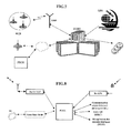
- buoys adapted to float on the surface of the water and each comprising a control module, a GPS-type satellite positioning signal receiver for example, and radio transmission means for exchanging data with the central station of control and recording, a plurality of background seismic acquisition stations each comprising a sealed body associated with a profiled part or arrow provided with a housing for seismic receivers, adapted to descend by the effect of gravity to the bottom of the body of water and to enter it so as to couple the seismic receptors with the underground formation, each acquisition station comprising a set of control and a device for acquiring seismic data received by the receivers seismic in the arrow.
- the system is characterized in that the relay buoys and the acquisition stations bottom seismic are each provided with an acoustic transmission device comprising an acoustic transponder, an acoustic positioning module and a acoustic communication module to communicate with them, by modem via the transponder, either positioning data or command data from the central station or seismic data acquired by the acquisition device at transmit to said central station.
- an acoustic transmission device comprising an acoustic transponder, an acoustic positioning module and a acoustic communication module to communicate with them, by modem via the transponder, either positioning data or command data from the central station or seismic data acquired by the acquisition device at transmit to said central station.
- the seismic acquisition stations are divided in several groups, each relay buoy being adapted to exchange data from positioning and control data or seismic data with the group of bottom acquisition stations closer to it than other relay buoys.
- each acquisition station comprises for example means for storing seismic recording traces corresponding to signals seismic received by the seismic receivers of each acquisition station and means in the control unit for controlling the delayed transfer according to a particular transmission frequency, to a relay buoy via its module acoustic communication of at least part of said stored seismic traces (i.e. the only quality data guaranteeing the proper functioning of the acquisition stations of background, i.e. the entire seismic traces if the distance between the acquisition stations and the relay buoys are not too large.
- each acquisition station includes means of optical transmission of the seismic data recorded at a relay buoy or an underwater vehicle passing in the vicinity of each of the acquisition stations.
- each acquisition station includes means for storing seismic recording traces corresponding to signals seismic received by the seismic receivers of each acquisition station and means, in the control unit, for forming data indicative of the voucher operation of said acquisition station and control the transfer according to a particular transmission frequency, data formed to a relay buoy (RCB) via its acoustic communication module.
- RTB relay buoy
- each relay buoy comprises means cooperating with the control module to acquire and date the relative acoustic signals positioning stations and transmit them to the central station at the same time time that its own coordinates received by the receiver of the positioning system by satellite.
- each relay buoy comprises means for record the seismic data acquired from the acquisition stations and at transmit to the central station.
- each acquisition station comprises means flotation associated with the waterproof body and release means for dissociating said body of the corresponding arrow, on command of the central station.
- each acquisition station includes means of coupling to an industrial transmission network, allowing direct transfer seismic data stored at the central station.
- the central station comprises a set of control comprising a central unit associated with storage means, and interface elements managing the exchanges between the central unit, and means of visualization and printing, mass storage means, means of communication with acquisition stations and relay buoys, sets of communication with radio relay buoys and receiving signal GPS positioning, and a set of control and triggering of a source seismic.
- each acquisition station includes means of optical transmission of the seismic data recorded at a relay buoy or a vehicle.
- each relay buoy comprises means for manage the transmission of the trigger signal from a seismic source in order to synchronize as best as possible the acquisition of seismic data by all of the background.
- the system includes a portable station for control and test to ensure the logistics of deployment and recovery of stations and their data, including means for locating stations acquisition after their ascent to the surface via a radio link, means for downloading data stored in acquisition stations and their recording, means of remote recovery of seismic data stored in relay buoys, and means for transferring seismic data to the central station control and recording via a communication network.
- It is characterized in that it involves the exchange between the relay buoys and the background seismic acquisition stations either of positioning data or of data from the central station or from the seismic data acquired by the background acquisition devices to be transmitted to said central station through of sets in each of said bottom acquisition devices and each of the buoys relay comprising an acoustic transponder, an acoustic positioning module and an acoustic communication module by modem.
- the method includes positioning and initial time synchronization of each bottom seismic acquisition station at when it is anchored, by reference to a satellite positioning system of GPS type for example, and tracking its descent to the bottom by combination of time synchronization and time measurement data obtained by telemetry acoustics between the acquisition station and the various relay buoys, up to stabilization of said station in contact with the bottom.
- the method includes acoustic transmission of seismic recording traces captured by the seismic receivers of each station acquisition to the corresponding relay buoy by means of said sets correspondents.
- the method includes acoustic transmission from each acquisition station to the corresponding relay buoy through the so-called corresponding sets of quality data indicative of the proper functioning of each acquisition station.
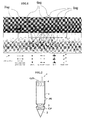
- Each DSAU acquisition station includes (Fig. 2) a cylindrical housing pressurized 1 adapted to contain the various constituent electronic modules.
- An arrow conical 2 is fixed with the base of the cylindrical casing 1 by means of a device removable attachment 3. It favors the descent of the station under the effect of gravity towards the bottom of the sea, substantially vertical to the drop location and coupling to the ground with sufficient background taking into account possible currents.
- Arrow 2 is decoupled mechanically from cylinder 1 and has housings for different sensors seismic S (at least one set comprising a three-component geophone or "Triphone" associated with a hydrophone).
- a flotation device 4 comprising buoys, a gas tank and a control element, is fixed above the housing cylindrical 1 in order to bring the station to the surface when the cylindrical housing is off the arrow 2.
- each station includes a mechanism (not shown) for propulsion into seabed sediments at the time of impact to ensure perfect coupling of sensors.
- the propulsion mechanism can be triggered either by the detection of the DSAU ground contact, either from a command received by the buoy RCB relay and control from the moment the positioning system has detected the establishment of the DSAU at the bottom of the water.
- each bottom station can also include several cylinders (two or three for example), fixed to a central axis supporting the boom conical.
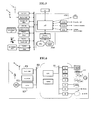
- the control unit UC comprises a microprocessor of the DSP (Digital Signal) type Processor) with low consumption.
- Programmable logic circuits are used to manage input-output resources, interrupts and specific interfaces for non-seismic sensors or devices such as the acoustic communication module ACM, RM release module, PLM positioning module, GPS receiver and the VHF radio transmitter / receiver in the RM release module, the storage module for DSM data and high and medium speed wired links for information exchange seismic or control towards the outside of the case.
- the application program of DSAU resides in re-programmable memory and dynamic data, parameters or seismic data, are contained in a random access memory with a suitable capacity.
- An oscillator, of the OCXO type (for "oven compensated crystal oscillator”) for example, with a precision of 2x10 -9 (1 ms / 5 days) will be necessary to ensure the precise dating of events either related to positioning or to seismic acquisition. For longer periods of use (beyond 5 days), it will certainly be necessary to provide a means of re-calibration.
- the synchronization of the clock as well as the date and the time will be carried out before the launching of the DSAU via the signal PPS (Pulse per second) of an internal or external GPS receiver. The accuracy of the date and time must be greater than 1 ⁇ s.
- the DAM data acquisition module is in charge of the receiver module seismic SRU including the 3C geophone, the PS hydrophone module and the ASU non-seismic sensors detecting power supply voltage, pressure for positioning, humidity in the housing, ground contact of the DSAU, the inclinometer and the compass.
- the circuits for digitizing the seismic signals received by the three-part geophone components X, Y, Z and the hydrophone P have for each channel (Fig. 4) a amplifier A and a filter F and an analog-to-digital ADC converter of the type Delta-Sigma with DF decimation filter, all low consumption.
- the conversion is done on 24 bits with a clock frequency of 2048 MHz.
- the sampling period will be 0.5 - 1 - 2 or 4 ms between 3 Hz and 824 - 412 - 206 - 103 Hz respectively.
- the signal dynamics is for example 120 dB.
- the digitization circuits for non-seismic sensors are functionally identical but the sampling period is much longer (1 s for example) and adapted according to the specifications of the specific devices used.
- the GP geophone module includes as standard a 3-component geophone and, optionally, an X-Y inclinometer and a magnetic compass.
- the basis of the module is profiled to allow optimal coupling suitable for S waves.
- This module is located in the arrow of the DSAU bottom acquisition station which is embedded in the sediments of the bottom of the sea to ensure perfect coupling of the sensors.
- the acquired seismic data is stored on a non-volatile medium, consisting of one or more disks based on flash memory technology or microdisks.
- the minimum storage capacity is for example 1 Gigabyte expandable up to 4 GB.
- a capacity of the order of 1 Gigabyte is sufficient to store some 26,000 shots of 10 s duration at a sampling period of 2 ms with a compression ratio of 1: 2.
- the shooting surface to be covered is of the order of 36 km 2 which corresponds to 28,800 shots at the rate of a firing point every 25 m and a space between lines 50 m.
- the principle of positioning the network of buoys positioned on the surface of the water is to measure the journey time of a signal emitted by a source acoustic, for example the transponder of an AUV underwater vehicle or from a DSAU bottom station.
- the acoustic source periodically emits two signals successive: the first synchronous at GPS time and the second offset according to the depth. These signals are received by all the buoys which date very precisely the arrival of these two signals with the corresponding GPS time.
- the buoy transmits by a radio link to the control system its own DGPS position associated with arrival times received by the DSAU. Knowing the speed of sound propagation in water, the propagation time is directly converted into a transponder / buoy distance. As the depth is measured precisely by each buoy, the position of the source acoustic is obtained by the intersection of circles having a radian equivalent to the range oblique in the horizontal plane.
- Positioning accuracy is on the order of a meter or less, depending on the depth of the device.
- the positioning system is activated as soon as each DSAU station is launched thus allowing the tracking of its trajectory in the water during the whole descent. Setting place of DSAU can be considered finished as soon as its position remains stable. The positioning system can then be deactivated until recovery or well to allow to check its position punctually during operations.
- this acoustic transponder is also used by the communication module acoustic.
- the two-way acoustic modem link will be used to transmit the orders related to the operations of the CCRU control and recording center on the boat to DSAUs via RCB buoys positioned on the surface and receive QC quality control data from it.
- This link will also used for precise synchronization of seismic fire. 1200 bit / s throughput example would transmit 150 bytes / s which would be sufficient to perform a almost continuous monitoring during seismic operations.
- Each RCB buoy is associated preferably an own acoustic frequency to communicate with the sets DSAU acquisition of the device that will be assigned to it. This also aims optimize the acoustic range.
- the commands will manage the different functionalities of the DSAU such management of the power supply, activation or deactivation of functions, their configuration, configuration for seismic acquisition, operations control seismic and data logging, etc.
- QC quality data transmitted from each DSAU station will allow to obtain an operating diagnosis: quality of the seismic signal, level control power supply, followed by data logging capacity, electronic control, etc.
- the release system will be triggered from a command from either the central CCRU record control, or the PTCU portable test system. This ensures the triggering of the release mechanism causing the container to rise to the surface and activation of localization devices for collection.
- the GP geophone module could possibly be disconnected from the DSAU and abandoned at the bottom of the sea, if the flotation assembly is not sufficient to clear the boom from the bottom.
- the DSAU station will activate the positioning system and will schedule, taking into account the ascent time, the activation delay GPS receiver, radio transmitter and visual location flash from the DSAU station.
- the radio transmitter will transmit the GPS coordinates to the relay buoys RCB or directly to the pickup ship.
- the transmitter will not be activated effectively only after the DSAU has risen to the surface of the water.
- the radio frequency used will be identical to that used for the RCB relay buoys link and control center and CCRU registration.
- the role of the TB sync module is to determine with precision ( ⁇ 100 ⁇ s) the moment of triggering the source and synchronizing the data acquired on this time.
- seismic acquisitions are started in synchronization with the triggering of the seismic source.
- This requires the transmission of a signal synchronization, TB (Time Break) in the case of seismic operations, from the source passing the CCRU control and recording center, RCB buoys to DSAU acquisition stations.
- TB Time Break
- CCRU control and registration center associates the time with the precise instant of the triggering of a seismic fire. This information is transmitted to DSAU background stations immediately after the synchronization signal acquisitions which allows them to re-synchronize the seismic samples acquired in applying the method described in patent FR 2,778,201 (US 6,253,156) to the applicant.
- the power supply module is designed so that it can be replaced easily and that the supply capacity can be adapted to the needs of the operation seismic. For short-term operations, you can probably use batteries alkaline, whereas for longer periods it will be necessary to use batteries at more expensive lithium.
- the autonomy of the food must be at least 7 days of quasi-continuous operations. As an option, the autonomy capacity must be extendable to 1 months or more.
- the microprocessor card is for example a PC card of industrial type with low consumption adapted to manage the disk and the subsequent transfer of seismic data which are stored there at the CCRU central control and recording station by a high speed communication network.
- Each RCB buoy is identified by its own address and has a frequency clean radio broadcast. The reception frequency is identical for all buoys.
- Each RCB buoy has its own acoustic frequency to communicate with the DSAU bottom stations of the system assigned to it. This also aims to optimize the acoustic range.
- the speed of the link can be chosen between 20 and 4800 bits / s according to the conditions of transmission. An average speed of 1200 bits / s is generally suitable.
- This module communicates with an acoustic transponder, a very precise and stable clock (10 -8 per month), the GPS receiver and the radio transceiver.
- the clock is synchronized with the 1 PPS (Pulse per Second) signal from the GPS receiver before setting up the relay buoy.
- the signal repetition period is 1 or 2 s for example.
- This interface is suitable for managing the transmission of the trigger signal of the seismic source in order to best synchronize acquisitions at the level of all DSAU background stations.
- each relay buoy can be adjusted taking into account its functionality and duration of operations.
- the batteries are packaged in a case independent of electronics to facilitate their replacement during operations, if necessary.
- a system for anchoring the buoy to the bottom of the water is preferable because it is less expensive.
- the deployment of the system is as follows:
- Each DSAU bottom station is configured, checked and synchronized on the bridge of the boat before launching.
- the DSAU bottom stations are then dropped successively overboard and fall by gravity to the bottom of the sea. Their positioning is monitored using the portable PTCU test system or central control and recording station CCRU. It is necessary to take into account the sea currents which risk introducing a more or less significant drift of the stations' trajectory towards the bottom.
- the descent speed of a DSAU station is 1 m / s and that the position we want to assign to it is 3000 m deep.
- the drop point is deviated by around 700 m in relation to the point sought.
- the difference can even reach several km.
- ocean currents are stronger at the surface than at depth.
- the acquisition of seismic data can begin.
- the data is stored in the DSM storage module (Fig. 3) from each background station.
- the bidirectional acoustic link between the DSAU bottom acquisition stations and the RCB relay buoys can also allow, if the water height is not too large and sufficient flow, to transmit at least part of the seismic traces to the surface recorded in the bottom acquisition stations.
- the DSAU bottom acquisition stations are recovered at the end of the shots seismic by acoustic activation of the attachment device 3 (Fig. 2) and release of acquisition boxes 1 which can rise to the surface.
- Visual devices, flag and flashes, and activation of the GPS receiver unit and the VHF transmitter will facilitate location and pick up of DSAU stations.
- the recovery of seismic data is carried out for example with the system of portable PTCU test which is connected to the central control and recording station CCRU via a link of a fast industrial network of Ethernet type by example.
- the DSAU bottom stations After reconditioning, replacement or recharging of the batteries and ballast, the DSAU bottom stations are operational again.
Landscapes
- Life Sciences & Earth Sciences (AREA)
- Physics & Mathematics (AREA)
- Geology (AREA)
- Engineering & Computer Science (AREA)
- Acoustics & Sound (AREA)
- Environmental & Geological Engineering (AREA)
- Oceanography (AREA)
- Remote Sensing (AREA)
- General Life Sciences & Earth Sciences (AREA)
- General Physics & Mathematics (AREA)
- Geophysics (AREA)
- Position Fixing By Use Of Radio Waves (AREA)
- Geophysics And Detection Of Objects (AREA)
- Arrangements For Transmission Of Measured Signals (AREA)
- Selective Calling Equipment (AREA)
Applications Claiming Priority (2)
| Application Number | Priority Date | Filing Date | Title |
|---|---|---|---|
| FR0116005A FR2833359B1 (fr) | 2001-12-10 | 2001-12-10 | Systeme d'acquisition de donnees sismiques utilisant des stations d'acquisition posees sur le fond marin |
| FR0116005 | 2001-12-10 |
Publications (3)
| Publication Number | Publication Date |
|---|---|
| EP1319964A2 true EP1319964A2 (de) | 2003-06-18 |
| EP1319964A3 EP1319964A3 (de) | 2003-07-02 |
| EP1319964B1 EP1319964B1 (de) | 2011-08-31 |
Family
ID=8870349
Family Applications (1)
| Application Number | Title | Priority Date | Filing Date |
|---|---|---|---|
| EP02292863A Expired - Lifetime EP1319964B1 (de) | 2001-12-10 | 2002-11-19 | Seismisches Datenerfassungssystem unter Verwendung von Datenerfassungsstationen auf dem Meeresgrund |
Country Status (7)
| Country | Link |
|---|---|
| US (1) | US7016260B2 (de) |
| EP (1) | EP1319964B1 (de) |
| JP (1) | JP4354686B2 (de) |
| CN (1) | CN1279368C (de) |
| CA (1) | CA2413036A1 (de) |
| FR (1) | FR2833359B1 (de) |
| NO (1) | NO20025831L (de) |
Cited By (13)
| Publication number | Priority date | Publication date | Assignee | Title |
|---|---|---|---|---|
| WO2011106237A2 (en) | 2010-02-23 | 2011-09-01 | Geco Technology B.V. | Seismic data acquisition using self-propelled underwater vehicles |
| US8881665B2 (en) | 2011-09-30 | 2014-11-11 | Cggveritas Services Sa | Deployment and recovery vessel for autonomous underwater vehicle for seismic survey |
| US9090319B2 (en) | 2011-09-30 | 2015-07-28 | Seabed Geosolutions As | Autonomous underwater vehicle for marine seismic surveys |
| US9381986B2 (en) | 2012-11-21 | 2016-07-05 | Seabed Geosolutions B.V. | Jet-pump-based autonomous underwater vehicle and method for coupling to ocean bottom during marine seismic survey |
| US9457879B2 (en) | 2012-12-17 | 2016-10-04 | Seabed Geosolutions B.V. | Self-burying autonomous underwater vehicle and method for marine seismic surveys |
| US9969470B2 (en) | 2011-09-30 | 2018-05-15 | Cgg Services Sas | Deployment and recovery of autonomous underwater vehicles for seismic survey |
| CN109686074A (zh) * | 2019-02-27 | 2019-04-26 | 深圳市斯迈耐特科技有限公司 | 八通道测力采集器 |
| US10322783B2 (en) | 2015-10-16 | 2019-06-18 | Seabed Geosolutions B.V. | Seismic autonomous underwater vehicle |
| US10543892B2 (en) | 2017-02-06 | 2020-01-28 | Seabed Geosolutions B.V. | Ocean bottom seismic autonomous underwater vehicle |
| US10823865B2 (en) | 2015-10-12 | 2020-11-03 | 4Cnode Geophysical As | Multi component sensor device for point measurements on the seabed during seismic surveys |
| US11059552B2 (en) | 2014-10-29 | 2021-07-13 | Seabed Geosolutions B.V. | Deployment and retrieval of seismic autonomous underwater vehicles |
| US11255998B2 (en) | 2018-05-17 | 2022-02-22 | Seabed Geosolutions B.V. | Cathedral body structure for an ocean bottom seismic node |
| WO2024126851A1 (fr) * | 2022-12-16 | 2024-06-20 | Technip Energies France | Unité de surveillance d'un sous-sol sous-marin et procédé associé |
Families Citing this family (157)
| Publication number | Priority date | Publication date | Assignee | Title |
|---|---|---|---|---|
| NO318314B1 (no) * | 2002-12-09 | 2005-02-28 | Seabed Geophysical As | Sensoranordning for seismiske bolger |
| US8466703B2 (en) * | 2003-03-14 | 2013-06-18 | Rudolph Technologies, Inc. | Probe card analysis system and method |
| US7974150B2 (en) * | 2003-05-16 | 2011-07-05 | Schlumberger Technology Corporation | Methods and apparatus of source control for sequential firing of staggered air gun arrays in borehole seismic |
| US7359282B2 (en) * | 2003-05-16 | 2008-04-15 | Schlumberger Technology Corporation | Methods and apparatus of source control for borehole seismic |
| US8687460B2 (en) * | 2003-05-16 | 2014-04-01 | Schlumberger Technology Corporation | Methods and apparatus of source control for synchronized firing of air gun arrays with receivers in a well bore in borehole seismic |
| US7310287B2 (en) | 2003-05-30 | 2007-12-18 | Fairfield Industries Incorporated | Method and apparatus for seismic data acquisition |
| US7561493B2 (en) * | 2003-05-30 | 2009-07-14 | Fairfield Industries, Inc. | Method and apparatus for land based seismic data acquisition |
| US7599249B2 (en) * | 2003-07-21 | 2009-10-06 | Westerngeco L.L.C. | Cable motion detection |
| GB0322859D0 (en) * | 2003-09-30 | 2003-10-29 | British Telecomm | Communication |
| US7667849B2 (en) * | 2003-09-30 | 2010-02-23 | British Telecommunications Public Limited Company | Optical sensor with interferometer for sensing external physical disturbance of optical communications link |
| US8824239B2 (en) * | 2004-03-17 | 2014-09-02 | Westerngeco L.L.C. | Marine seismic survey method and system |
| US6995707B2 (en) * | 2004-03-18 | 2006-02-07 | The United States Of America As Represented By The Secretary Of The Navy | Integrated maritime portable acoustic scoring and simulator control and improvements |
| GB0407386D0 (en) * | 2004-03-31 | 2004-05-05 | British Telecomm | Monitoring a communications link |
| CN1332226C (zh) * | 2004-08-06 | 2007-08-15 | 中国科学院海洋研究所 | 一种深海潜标测量系统 |
| US7233545B2 (en) | 2004-09-08 | 2007-06-19 | Mcginn-Harvey Holdings, Llc | System and method for determining the location of an acoustic event |
| CN102788992B (zh) * | 2004-09-21 | 2016-09-28 | 费尔菲尔德工业公司 | 用于地震数据采集的方法和设备 |
| EP3699647A1 (de) * | 2004-09-21 | 2020-08-26 | Magseis FF LLC | Verfahren und vorrichtung zur erfassung seismischer daten |
| US7848645B2 (en) * | 2004-09-30 | 2010-12-07 | British Telecommunications Public Limited Company | Identifying or locating waveguides |
| GB0421747D0 (en) * | 2004-09-30 | 2004-11-03 | British Telecomm | Distributed backscattering |
| US20060083109A1 (en) | 2004-10-14 | 2006-04-20 | Tsunehisa Kimura | Seismic source controller and display system |
| GB0427733D0 (en) * | 2004-12-17 | 2005-01-19 | British Telecomm | Optical system |
| US8045174B2 (en) | 2004-12-17 | 2011-10-25 | British Telecommunications Public Limited Company | Assessing a network |
| US8534959B2 (en) | 2005-01-17 | 2013-09-17 | Fairfield Industries Incorporated | Method and apparatus for deployment of ocean bottom seismometers |
| GB0504579D0 (en) | 2005-03-04 | 2005-04-13 | British Telecomm | Communications system |
| DE602006007442D1 (de) * | 2005-03-04 | 2009-08-06 | British Telecomm Public Ltd Co | Akustooptische modulatoranordnung |
| EP1708388A1 (de) | 2005-03-31 | 2006-10-04 | British Telecommunications Public Limited Company | Verfahren zum Mitteilen von Informationen |
| FR2884323B1 (fr) * | 2005-04-07 | 2007-06-15 | Geophysique Cie Gle | Procede d'acquisition sismique au fond de la mer, equipement de guidage, ensemble d'acquisition sismique et installation d'acquisition sismique pour la mise en oeuvre de ce procede |
| EP1713301A1 (de) * | 2005-04-14 | 2006-10-18 | BRITISH TELECOMMUNICATIONS public limited company | Verfahren und Gerät zur Schallübertragung über eine optische Verbindung |
| US8127706B2 (en) * | 2005-05-02 | 2012-03-06 | Fairfield Industries Incorporated | Deck configuration for ocean bottom seismometer launch platforms |
| EP1729096A1 (de) * | 2005-06-02 | 2006-12-06 | BRITISH TELECOMMUNICATIONS public limited company | Verfahren und Vorrichtung zur Ermittlung der Stelle einer Störung in einer optischen Faser |
| US7333394B2 (en) * | 2005-06-22 | 2008-02-19 | Basilico Albert R | Navigational aid for diver |
| US7272074B2 (en) * | 2005-07-15 | 2007-09-18 | Basilico Albert R | System and method for extending GPS to divers and underwater vehicles |
| US7969822B2 (en) * | 2005-07-15 | 2011-06-28 | Estate Of Albert R. Basilico | System and method for extending GPS to divers and underwater vehicles |
| EP1915656B1 (de) * | 2005-08-16 | 2011-10-19 | VEGA Grieshaber KG | Automatisierungsnetz-feldgerät mit ultraschall-kommunikationsverbindung |
| US7433265B2 (en) * | 2005-10-04 | 2008-10-07 | Fairfield Industries, Inc. | Converted wave energy removal from seismic data |
| US7773457B2 (en) * | 2005-10-07 | 2010-08-10 | Wireless Seismic | Wireless exploration seismic system |
| US8238199B2 (en) * | 2005-10-07 | 2012-08-07 | Wireless Seismic, Inc. | Wireless exploration seismic system |
| US9294201B2 (en) | 2006-02-06 | 2016-03-22 | Woods Hole Oceanographic Institution | Optical communication systems and methods |
| WO2007096579A1 (en) * | 2006-02-24 | 2007-08-30 | British Telecommunications Public Limited Company | Sensing a disturbance |
| EP1826924A1 (de) * | 2006-02-24 | 2007-08-29 | BRITISH TELECOMMUNICATIONS public limited company | Abtastung einer Störung |
| WO2007096578A1 (en) * | 2006-02-24 | 2007-08-30 | British Telecommunications Public Limited Company | Sensing a disturbance |
| CA2647173A1 (en) * | 2006-04-03 | 2007-10-11 | British Telecommunications Public Company Limited | Evaluating the position of a disturbance |
| US7366055B2 (en) * | 2006-05-05 | 2008-04-29 | Optoplan As | Ocean bottom seismic sensing system |
| US8064286B2 (en) * | 2006-05-05 | 2011-11-22 | Optoplan As | Seismic streamer array |
| US20070286022A1 (en) * | 2006-06-09 | 2007-12-13 | Input/Output, Inc. | Operating State Management for Seismic Data Acquisition |
| US20080021658A1 (en) * | 2006-06-10 | 2008-01-24 | Input/Output, Inc. | Apparatus and Method for Integrating Survey Parameters Into a Header |
| US20070286021A1 (en) * | 2006-06-10 | 2007-12-13 | Input/Output, Inc. | One Touch Data Acquisition |
| CA2654949A1 (en) * | 2006-06-10 | 2007-12-13 | Ion Geophysical Corporation | Digital elevation model for use with seismic data acquisition systems |
| CN100447826C (zh) * | 2006-12-01 | 2008-12-31 | 哈尔滨工程大学 | 定位通信一体化浮标 |
| CN1971305B (zh) * | 2006-12-01 | 2010-09-08 | 哈尔滨工程大学 | 智能深水应答器 |
| US7796466B2 (en) * | 2006-12-13 | 2010-09-14 | Westerngeco L.L.C. | Apparatus, systems and methods for seabed data acquisition |
| US20080147328A1 (en) | 2006-12-15 | 2008-06-19 | Jun Wang | Generating a Geographic Representation of a Network of Seismic Devices |
| WO2008079307A1 (en) * | 2006-12-19 | 2008-07-03 | Rudolph Technologies, Inc. | Probe card analysis system and method |
| CN100428287C (zh) * | 2006-12-21 | 2008-10-22 | 上海交通大学 | 变深度声纳浮标探测阵列 |
| JP5117728B2 (ja) * | 2007-01-11 | 2013-01-16 | 株式会社リコー | シート処理装置、画像形成装置及びシート処理方法 |
| JP5076653B2 (ja) * | 2007-06-07 | 2012-11-21 | 日本電気株式会社 | 通信システム、通信方法および基地局装置 |
| GB2451427A (en) * | 2007-07-25 | 2009-02-04 | Vetco Gray Controls Ltd | Electronic card communication |
| US8898019B2 (en) * | 2007-09-21 | 2014-11-25 | Geospace Technologies, Lp | Low-power satellite-timed seismic data acquisition system |
| US20090140926A1 (en) * | 2007-12-04 | 2009-06-04 | Elden Douglas Traster | System and method for localization utilizing dynamically deployable beacons |
| US8611191B2 (en) | 2008-05-22 | 2013-12-17 | Fairfield Industries, Inc. | Land based unit for seismic data acquisition |
| CN101280681B (zh) * | 2008-05-29 | 2012-04-04 | 北京金禾创业科技发展有限公司 | 采用gps定位技术的油井憋压试验记录仪 |
| RU2410725C2 (ru) * | 2008-06-18 | 2011-01-27 | Специальное конструкторское бюро средств автоматизации морских исследований Дальневосточного отделения Российской академии наук | Буйковая гидроакустическая станция для определения предвестников сильных землетрясений и цунами |
| US8233801B2 (en) * | 2008-08-18 | 2012-07-31 | Vetco Gray Inc. | Wireless high capacity sub-sea communications system |
| RU2405176C2 (ru) * | 2008-09-15 | 2010-11-27 | Специальное конструкторское бюро средств автоматизации морских исследований Дальневосточного отделения Российской академии наук | Дрейфующая буйковая гидроакустическая станция для определения предвестников сильных землетрясений и цунами |
| US9274238B2 (en) * | 2008-11-08 | 2016-03-01 | Westerngeco L.L.C. | Reliable broadcast delivery of communications in land-based seismic surveying |
| WO2010059304A1 (en) * | 2008-11-21 | 2010-05-27 | Exxonmobil Upstream Research Company | Free charge carrier diffusion response transducer for sensing gradients |
| US8138417B2 (en) * | 2009-03-24 | 2012-03-20 | Leach Dana N | Underground storage of operational electronic equipment |
| US20110176383A1 (en) * | 2010-01-19 | 2011-07-21 | Fairfield Industries Incorporated | Method and apparatus for accurate placement of ocean bottom seismic instrumentation |
| US8579545B2 (en) | 2010-03-02 | 2013-11-12 | Fairfield Industries Incorporated | Apparatus and methods for an ocean bottom seismic sensor deployment vehicle |
| US9250344B2 (en) * | 2010-10-13 | 2016-02-02 | The Petroleum Institute | Method to acquire seismic data in shallow sea water environment |
| JP2013545980A (ja) * | 2010-11-08 | 2013-12-26 | シュルンベルジェ ホールディングス リミテッド | 掘削機と表面装置との間でデータを通信するシステムおよび方法 |
| CN102255981B (zh) * | 2011-07-11 | 2013-10-16 | 中国石油天然气集团公司 | 一种高效可靠的采集站地址分配方法及系统 |
| US20130023131A1 (en) * | 2011-07-20 | 2013-01-24 | Cggveritas Services Sa | Connecting part between lead-in and marine streamer and method |
| US8403389B1 (en) * | 2011-09-29 | 2013-03-26 | The United States Of America As Represented By The Secretary Of The Navy | Device for recovery of physical objects |
| CN102442416B (zh) * | 2011-10-20 | 2013-11-13 | 中国船舶重工集团公司第七一〇研究所 | 长线阵水下浮动平台 |
| RU2483330C1 (ru) * | 2011-12-22 | 2013-05-27 | Юрий Николаевич Жуков | Способ регистрации сейсмических сигналов на акватории моря при поиске подводных залежей углеводородов |
| AU2013211950B2 (en) * | 2012-01-25 | 2016-03-10 | Inova Ltd. | High-precision time synchronization for a cabled network in linear topology |
| CA2864094A1 (en) * | 2012-02-09 | 2013-08-15 | Inova Ltd. | Method of seismic source synchronization |
| EP2657723B1 (de) * | 2012-04-26 | 2014-11-12 | Vetco Gray Controls Limited | Drahtloser Unterwasser-Erdbebensensor und Datensammelverfahren |
| EP2657725B1 (de) * | 2012-04-27 | 2015-01-14 | Sercel | Verfahren und System zur Verwaltung eines seismischen Systems mit mehreren Schiffen |
| RU2540454C2 (ru) * | 2012-05-11 | 2015-02-10 | Федеральное бюджетное государственное учреждение "Специальное конструкторское бюро средств автоматизации морских исследований Дальневосточного отделения Российской академии наук | Малогабаритная автономная сейсмоакустическая станция |
| NO337136B1 (no) * | 2012-05-16 | 2016-01-25 | Scantrawl As | Akustisk avstandsmåling til trål |
| EP2690468B1 (de) * | 2012-07-27 | 2019-03-27 | Sercel | Schleppvorrichtung für die seismische Vorhersage mit Kippausgleich von direktionalen Sensoren |
| NO336544B1 (no) * | 2012-08-16 | 2015-09-21 | Magseis As | Autonom seismisk node for havbunnen omfattende en referanseoscillator |
| CN102829770B (zh) * | 2012-08-20 | 2015-05-06 | 国家海洋技术中心 | Gps浮标测波方法和测波系统 |
| JP6025456B2 (ja) * | 2012-08-28 | 2016-11-16 | キヤノン株式会社 | 被検体情報取得装置、表示方法、及びプログラム |
| US20140126325A1 (en) * | 2012-11-02 | 2014-05-08 | Silixa Ltd. | Enhanced seismic surveying |
| RU2513635C1 (ru) * | 2012-12-13 | 2014-04-20 | Андрей Федорович Зеньков | Термозонд для измерения вертикального распределения температуры воды |
| US20140185408A1 (en) * | 2012-12-28 | 2014-07-03 | Vladimir Eduardovich Kyasper | Bottom seismic system |
| US9490911B2 (en) | 2013-03-15 | 2016-11-08 | Fairfield Industries Incorporated | High-bandwidth underwater data communication system |
| US9490910B2 (en) | 2013-03-15 | 2016-11-08 | Fairfield Industries Incorporated | High-bandwidth underwater data communication system |
| US9845137B2 (en) | 2013-03-20 | 2017-12-19 | Seabed Geosolutions B.V. | Methods and underwater bases for using autonomous underwater vehicle for marine seismic surveys |
| CN103399359A (zh) * | 2013-08-21 | 2013-11-20 | 国家海洋局第二海洋研究所 | 一种海底地球物理观测装置 |
| US10033469B2 (en) * | 2013-08-29 | 2018-07-24 | Battelle Memorial Institute | Injectable acoustic transmission devices and process for making and using same |
| US10033470B2 (en) | 2013-08-29 | 2018-07-24 | Battelle Memorial Institute | Acoustic transmission devices and process for making and using same |
| WO2015125015A2 (en) | 2014-02-19 | 2015-08-27 | Cgg Services Sa | Systems and methods for wireless data acquisition in seismic monitoring systems |
| RU2554283C1 (ru) * | 2014-03-25 | 2015-06-27 | Нина Владимировна Червякова | Малогабаритный донный сейсмический модуль |
| CN103941579B (zh) * | 2014-04-09 | 2016-08-17 | 浙江理工大学 | 一种用于海洋仪器的时刻记录和时钟同步方法 |
| WO2015187396A2 (en) | 2014-06-06 | 2015-12-10 | Austin Star Detonator Company | Methods and apparatus for confirmation time break (ctb) determination and shotpoint in-situ recording in seismic electronic detonators |
| US20160011324A1 (en) * | 2014-07-11 | 2016-01-14 | Sercel | Method For Harvesting Seismic Data And Generating Seismic Output Files |
| CN104166121B (zh) * | 2014-08-07 | 2016-09-14 | 广州市香港科大霍英东研究院 | 一种海洋无线传感器网络定位方法 |
| CN104155695B (zh) * | 2014-08-15 | 2017-03-15 | 中国科学院地质与地球物理研究所 | 潜水式浮标地震数据采集站 |
| CN104202569B (zh) * | 2014-09-02 | 2018-09-21 | 青岛市光电工程技术研究院 | 分布式水下微光监控系统 |
| GB2531032B (en) * | 2014-10-07 | 2021-01-06 | Aker Solutions Ltd | Subsea electronics module |
| CN104570158B (zh) | 2015-01-07 | 2015-11-04 | 中国科学院南海海洋研究所 | 一种自浮式海底热流长期观测基站 |
| US10101429B2 (en) | 2015-02-25 | 2018-10-16 | Battelle Memorial Institute | Acoustic transmission device and process for tracking selected hosts |
| JP6294563B2 (ja) | 2015-03-23 | 2018-03-14 | 株式会社日立製作所 | センサ端末の故障または異常の検出方法 |
| KR101720328B1 (ko) * | 2015-06-12 | 2017-03-28 | 한국해양과학기술원 | 해양의 지열량 측정 장치 |
| RU2598622C1 (ru) * | 2015-07-21 | 2016-09-27 | Общество с ограниченной ответственностью "Региональные Геофизические Исследования" | Система и способ сбора сейсмических данных |
| RU2614659C2 (ru) * | 2015-08-04 | 2017-03-28 | Федеральное государственное бюджетное учреждение науки Федеральный исследовательский центр "Единая геофизическая служба Российской академии наук" | Система регистрации инфразвуковых сигналов |
| US10067112B2 (en) | 2015-09-30 | 2018-09-04 | Battelle Memorial Institute | Autonomous sensor fish to support advanced hydropower development |
| US10236920B2 (en) | 2015-12-15 | 2019-03-19 | Battelle Memorial Institute | Signal transmitter and methods for transmitting signals from animals |
| US11278004B2 (en) | 2015-12-15 | 2022-03-22 | Battelle Memorial Institute | Transmitters for animals and methods for transmitting from animals |
| US20170346557A1 (en) * | 2016-05-25 | 2017-11-30 | Korea Maritime and Ocean University Research and Development Business Foundation | Underwater visible light transceiving terminal |
| US10488537B2 (en) | 2016-06-30 | 2019-11-26 | Magseis Ff Llc | Seismic surveys with optical communication links |
| RU2625100C1 (ru) * | 2016-07-22 | 2017-07-11 | Владимир Васильевич Чернявец | Способ прогнозирования сейсмического события и наблюдательная система для сейсмических исследований |
| US20180048713A1 (en) * | 2016-08-09 | 2018-02-15 | Sciemetric Instruments Inc. | Modular data acquisition and control system |
| US10531639B2 (en) | 2016-08-25 | 2020-01-14 | Battelle Memorial Institute | Systems and methods for monitoring organisms within an aquatic environment |
| RU169150U1 (ru) * | 2016-09-08 | 2017-03-07 | Российская Федерация, от имени которой выступает Министерство промышленности и торговли Российской Федерации (Минпромторг) | Устройство оперативного оценивания вертикального распределения скорости звука в мировом океане для обеспечения гидроакустических расчетов и прогноза дальности действия гидроакустических средств |
| JP6965506B2 (ja) * | 2016-10-06 | 2021-11-10 | 富士フイルムビジネスイノベーション株式会社 | 水中移動体及び水中通信システム |
| CN106501860B (zh) * | 2016-10-14 | 2019-05-24 | 中国船舶工业系统工程研究院 | 一种应用于海洋物探的全局解算定位方法 |
| RU2650849C1 (ru) * | 2017-03-10 | 2018-04-17 | Владимир Васильевич Чернявец | Автономная сейсмоакустическая станция |
| RU171967U1 (ru) * | 2017-03-20 | 2017-06-22 | Федеральное государственное бюджетное учреждение науки Тихоокеанский океанологический институт им. В.И. Ильичева Дальневосточного отделения Российской академии наук (ТОИ ДВО РАН) | Автономный регистратор гидрофизических полей |
| JP6945335B2 (ja) * | 2017-04-24 | 2021-10-06 | 池上通信機株式会社 | 液中投入用の送信装置 |
| CN107192983B (zh) * | 2017-07-04 | 2023-11-17 | 深圳潜行创新科技有限公司 | 一种观测水下潜航器相对位置的装置、方法和系统 |
| CN107179554B (zh) * | 2017-07-17 | 2023-08-22 | 国家深海基地管理中心 | 一种海底地震探测装置及探测方法 |
| CN108037534B (zh) * | 2017-12-27 | 2024-08-27 | 国家深海基地管理中心 | 一种基于水下移动平台的水声阵列装置 |
| JP7079930B2 (ja) * | 2018-04-25 | 2022-06-03 | 株式会社ソニック | マルチチャンネルストリーマケーブル |
| CN108645445B (zh) * | 2018-05-18 | 2020-07-07 | 中国海洋石油集团有限公司 | 一种用于海底管柱的光纤分布式监测系统 |
| EP4276008A3 (de) | 2018-05-23 | 2024-05-29 | Blue Ocean Seismic Services Limited | System zur autonomen datenerfassung |
| CN108414982A (zh) * | 2018-05-29 | 2018-08-17 | 中国科学院声学研究所 | 一种用于水声定位的通信浮标及其组网 |
| NO344845B1 (en) * | 2018-07-10 | 2020-05-25 | Magseis Asa | A seismic node for an ocean bottom seismic survey comprising a seismic sensor capsule and a seafloor casing, a method for performing an ocean bottom seismic survey and the use of the seismic node for achieving the method |
| CN109298452B (zh) * | 2018-09-12 | 2023-08-01 | 国家海洋局第一海洋研究所 | 一种卫星传输海底地震探测装置 |
| CN109061720B (zh) | 2018-09-12 | 2023-10-20 | 国家海洋局第一海洋研究所 | 一种基于海底物联网的海底地震监测装置及系统 |
| JP6766122B2 (ja) * | 2018-11-12 | 2020-10-07 | 応用地質株式会社 | 水底微動探査装置 |
| WO2020121173A1 (en) * | 2018-12-09 | 2020-06-18 | Hemisens Technologies Ltd | Sensing devices, systems and methods |
| CN110058309A (zh) * | 2018-12-13 | 2019-07-26 | 广州海洋地质调查局 | 一种立体时移地震观测系统及方法 |
| US11533818B2 (en) | 2019-03-12 | 2022-12-20 | Battelle Memorial Institute | Sensor assemblies and methods for emulating interaction of entities within water systems |
| CN110320560A (zh) * | 2019-07-09 | 2019-10-11 | 浙江大学 | 一种海洋地震和海啸实时监测系统 |
| JP2021018172A (ja) * | 2019-07-22 | 2021-02-15 | 有限会社手島通商 | 地震に関するデータの測定方法 |
| WO2021058051A1 (de) * | 2019-09-26 | 2021-04-01 | Geomar Helmholtz-Zentrum Für Ozeanforschung Kiel | Meeresbodenmessungen-messeinheit, meeresbodenmessungen-messeinheiten-sensorschwarm und einsatzverfahren dafür |
| CN110686766A (zh) * | 2019-10-28 | 2020-01-14 | 海鹰企业集团有限责任公司 | 一种自容式水听器装置及系统 |
| CN111399058A (zh) * | 2020-04-28 | 2020-07-10 | 中国石油大学(华东) | 一种组合式海底地震采集节点 |
| CN111800614B (zh) * | 2020-07-08 | 2021-03-23 | 浙江大学 | 一种基于水声通信机组网的水质图像采集和信息传输系统及其方法 |
| CN111781648A (zh) * | 2020-08-03 | 2020-10-16 | 广东欧深科技有限公司 | 一种海洋信息探测集群系统及探测方法 |
| US20240094421A1 (en) * | 2021-01-14 | 2024-03-21 | Schlumberger Technology Corporation | Marine seismic imaging |
| JP2022131633A (ja) * | 2021-02-26 | 2022-09-07 | 日本電気株式会社 | 量子センシングデバイス、量子センシングシステム、量子センシング方法、およびプログラム |
| RU2770130C1 (ru) * | 2021-04-27 | 2022-04-14 | Владимир Васильевич Чернявец | Дрейфующая буйковая гидроакустическая станция для определения предвестников сильных землетрясений и цунами на акваториях с ледовым покровом |
| RU208856U1 (ru) * | 2021-05-25 | 2022-01-18 | Акционерное Общество "Концерн "Океанприбор" | Устройство гидроакустических расчетов по данным оперативной океанологии |
| CN115903010B (zh) * | 2021-08-26 | 2025-07-08 | 中国石油天然气集团有限公司 | 海洋地震节点采集装置 |
| CN114189820B (zh) * | 2021-11-17 | 2023-09-12 | 青岛杰瑞自动化有限公司 | 一种浮标数据采集系统及控制方法 |
| CN114721066B (zh) * | 2022-03-14 | 2025-07-22 | 中煤科工集团西安研究院有限公司 | 一种适用于固体地震物理模拟的自适应精准耦合方法及系统 |
| CN116045923A (zh) * | 2023-04-03 | 2023-05-02 | 国家海洋技术中心 | 一种温盐深测量仪及系统 |
| CN116400408B (zh) * | 2023-06-09 | 2023-08-18 | 厦门大学 | 具有在线数据传输和水下定位功能的智能海底地震仪 |
| CN116567681B (zh) * | 2023-06-14 | 2025-12-02 | 杭州电子科技大学 | 异构通信级联的远程可控海底观测系统及其数据传输方法 |
| NO349252B1 (en) * | 2024-04-03 | 2025-11-17 | Allton Norway AS | A deployment system for deploying equipment to a floor of a body of water from a vessel, and methods of deploying and retrieving equipment |
| CN119535605B (zh) * | 2024-10-11 | 2026-01-06 | 中国科学院深圳先进技术研究院 | 一种基于海底潜标的时移地震数据准实时传输方法 |
Family Cites Families (13)
| Publication number | Priority date | Publication date | Assignee | Title |
|---|---|---|---|---|
| US3903497A (en) * | 1974-06-14 | 1975-09-02 | Us Navy | Opto-acoustic hydrophone |
| US4309763A (en) * | 1977-03-02 | 1982-01-05 | Refraction Technology, Inc. | Digital sonobuoy |
| US4463451A (en) * | 1982-01-11 | 1984-07-31 | The Standard Oil Company | System for seismic digital data acquisition over water covered areas |
| JPH0820506B2 (ja) * | 1986-09-10 | 1996-03-04 | 海洋科学技術センター | 海洋音響トモグラフィーデータ伝送装置 |
| FR2608780B1 (fr) * | 1986-12-23 | 1989-05-19 | Inst Francais Du Petrole | Procede de transmission a un dispositif central d'enregistrement de donnees sismiques collectees par des appareils d'acquisition repartis sur le terrain et dispositif pour sa mise en oeuvre |
| NO168557C (no) * | 1989-10-26 | 1992-03-04 | Norske Stats Oljeselskap | Seismisk anordning. |
| US5113377A (en) * | 1991-05-08 | 1992-05-12 | Atlantic Richfield Company | Receiver array system for marine seismic surveying |
| US5189642A (en) * | 1991-09-10 | 1993-02-23 | Chevron Research And Technology Company | Seafloor seismic recorder |
| US5691957A (en) * | 1994-06-30 | 1997-11-25 | Woods Hole Oceanographic Institution | Ocean acoustic tomography |
| US5452262A (en) * | 1994-10-11 | 1995-09-19 | The United States Of America As Represented By The Secretary Of The Navy | Radio telemetry buoy for long-range communication |
| FR2772931B1 (fr) * | 1997-12-24 | 2001-04-20 | Geophysique Cie Gle | Systeme pour le suivi de la mise en place d'un cable sismique sur un fond marin a partir d'un bateau |
| US6058071A (en) * | 1998-08-10 | 2000-05-02 | The United States Of America As Represented By The Secretary Of The Navy | Magneto-inductive submarine communications system and buoy |
| FR2818388B1 (fr) * | 2000-12-15 | 2003-02-14 | Inst Francais Du Petrole | Methode et dispositif d'exploration sismique d'une zone souterraine immergee, utilisant des recepteurs sismiques couples avec le fond de l'eau |
-
2001
- 2001-12-10 FR FR0116005A patent/FR2833359B1/fr not_active Expired - Fee Related
-
2002
- 2002-11-19 EP EP02292863A patent/EP1319964B1/de not_active Expired - Lifetime
- 2002-12-04 NO NO20025831A patent/NO20025831L/no not_active Application Discontinuation
- 2002-12-06 US US10/310,818 patent/US7016260B2/en not_active Expired - Fee Related
- 2002-12-09 CA CA002413036A patent/CA2413036A1/fr not_active Abandoned
- 2002-12-10 CN CN02156133.8A patent/CN1279368C/zh not_active Expired - Fee Related
- 2002-12-10 JP JP2002358455A patent/JP4354686B2/ja not_active Expired - Fee Related
Cited By (20)
| Publication number | Priority date | Publication date | Assignee | Title |
|---|---|---|---|---|
| EP2539742A4 (de) * | 2010-02-23 | 2015-05-13 | Geco Technology Bv | Beschaffung seismischer daten unter verwendung von unterwasserfahrzeugen mit eigenantrieb |
| WO2011106237A2 (en) | 2010-02-23 | 2011-09-01 | Geco Technology B.V. | Seismic data acquisition using self-propelled underwater vehicles |
| US9575198B2 (en) | 2010-02-23 | 2017-02-21 | Westerngeco L.L.C. | Seismic data acquisition using self-propelled underwater vehicles |
| US9969470B2 (en) | 2011-09-30 | 2018-05-15 | Cgg Services Sas | Deployment and recovery of autonomous underwater vehicles for seismic survey |
| US8881665B2 (en) | 2011-09-30 | 2014-11-11 | Cggveritas Services Sa | Deployment and recovery vessel for autonomous underwater vehicle for seismic survey |
| US9090319B2 (en) | 2011-09-30 | 2015-07-28 | Seabed Geosolutions As | Autonomous underwater vehicle for marine seismic surveys |
| US9487275B2 (en) | 2011-09-30 | 2016-11-08 | Cgg Services Sa | Deployment and recovery vessel for autonomous underwater vehicle for seismic survey |
| US9821894B2 (en) | 2011-09-30 | 2017-11-21 | Seabed Geosolutions As | Autonomous underwater vehicle for marine seismic surveys |
| US9381986B2 (en) | 2012-11-21 | 2016-07-05 | Seabed Geosolutions B.V. | Jet-pump-based autonomous underwater vehicle and method for coupling to ocean bottom during marine seismic survey |
| US9821895B2 (en) | 2012-11-21 | 2017-11-21 | Seabed Geosolutions B.V. | Autonomous underwater vehicle and method for coupling to ocean bottom during marine seismic survey |
| US9457879B2 (en) | 2012-12-17 | 2016-10-04 | Seabed Geosolutions B.V. | Self-burying autonomous underwater vehicle and method for marine seismic surveys |
| US11059552B2 (en) | 2014-10-29 | 2021-07-13 | Seabed Geosolutions B.V. | Deployment and retrieval of seismic autonomous underwater vehicles |
| US10823865B2 (en) | 2015-10-12 | 2020-11-03 | 4Cnode Geophysical As | Multi component sensor device for point measurements on the seabed during seismic surveys |
| US10322783B2 (en) | 2015-10-16 | 2019-06-18 | Seabed Geosolutions B.V. | Seismic autonomous underwater vehicle |
| US10543892B2 (en) | 2017-02-06 | 2020-01-28 | Seabed Geosolutions B.V. | Ocean bottom seismic autonomous underwater vehicle |
| US11267546B2 (en) | 2017-02-06 | 2022-03-08 | Seabed Geosolutions B.V. | Ocean bottom seismic autonomous underwater vehicle |
| US11255998B2 (en) | 2018-05-17 | 2022-02-22 | Seabed Geosolutions B.V. | Cathedral body structure for an ocean bottom seismic node |
| CN109686074A (zh) * | 2019-02-27 | 2019-04-26 | 深圳市斯迈耐特科技有限公司 | 八通道测力采集器 |
| WO2024126851A1 (fr) * | 2022-12-16 | 2024-06-20 | Technip Energies France | Unité de surveillance d'un sous-sol sous-marin et procédé associé |
| FR3143773A1 (fr) * | 2022-12-16 | 2024-06-21 | Technip Energies France | Unité de surveillance d’un sous-sol sous-marin et procédé associé |
Also Published As
| Publication number | Publication date |
|---|---|
| CA2413036A1 (fr) | 2003-06-10 |
| US20030117893A1 (en) | 2003-06-26 |
| CN1424592A (zh) | 2003-06-18 |
| JP4354686B2 (ja) | 2009-10-28 |
| EP1319964B1 (de) | 2011-08-31 |
| CN1279368C (zh) | 2006-10-11 |
| US7016260B2 (en) | 2006-03-21 |
| EP1319964A3 (de) | 2003-07-02 |
| FR2833359B1 (fr) | 2004-04-23 |
| JP2003232865A (ja) | 2003-08-22 |
| FR2833359A1 (fr) | 2003-06-13 |
| NO20025831L (no) | 2003-06-11 |
| NO20025831D0 (no) | 2002-12-04 |
Similar Documents
| Publication | Publication Date | Title |
|---|---|---|
| EP1319964B1 (de) | Seismisches Datenerfassungssystem unter Verwendung von Datenerfassungsstationen auf dem Meeresgrund | |
| AU2004275381B2 (en) | Single station wireless seismic data acquisition method and apparatus | |
| US6932185B2 (en) | Acquisition method and device for seismic exploration of a geologic formation by permanent receivers set on the sea bottom | |
| US11422274B2 (en) | Seismic surveys with optical communication links | |
| US6024344A (en) | Method for recording seismic data in deep water | |
| US8335128B2 (en) | Single station wireless seismic data acquisition method and apparatus | |
| CA2364190A1 (fr) | Methode et dispositif d'exploitation sismique d'une zone souterraine immergee, utilisant des recepteurs sismiques couples avec le fond de l'eau | |
| NO20180048A1 (en) | Node Hub – a seismic reservoir monitoring system for deployment on the seafloor in marine seismic surveys, and a method for deployment of seismic sensor nodes on the seafloor and collecting the seismic sensor nodes. | |
| FR2952189A1 (fr) | Procede de detection et de localisation d'une source accoustique immergee a grande profondeur | |
| WO2018005151A1 (en) | Seismic surveys with optical communication links | |
| Brückmann et al. | West-Nil-Delta-Projekt: POSEIDON-Fahrt 388, Logbuch POS388 | |
| GB2569550A (en) | A method and system for acquiring seismic data | |
| BR122019008086B1 (pt) | Sondagens sísmicas com ligações de comunicação óptica |
Legal Events
| Date | Code | Title | Description |
|---|---|---|---|
| PUAI | Public reference made under article 153(3) epc to a published international application that has entered the european phase |
Free format text: ORIGINAL CODE: 0009012 |
|
| PUAL | Search report despatched |
Free format text: ORIGINAL CODE: 0009013 |
|
| AK | Designated contracting states |
Designated state(s): AT BE BG CH CY CZ DE DK EE ES FI FR GB GR IE IT LI LU MC NL PT SE SK TR |
|
| AX | Request for extension of the european patent |
Extension state: AL LT LV MK RO SI |
|
| AK | Designated contracting states |
Designated state(s): AT BE BG CH CY CZ DE DK EE ES FI FR GB GR IE IT LI LU MC NL PT SE SK TR |
|
| AX | Request for extension of the european patent |
Extension state: AL LT LV MK RO SI |
|
| 17P | Request for examination filed |
Effective date: 20040102 |
|
| AKX | Designation fees paid |
Designated state(s): DE GB NL |
|
| 17Q | First examination report despatched |
Effective date: 20100518 |
|
| GRAP | Despatch of communication of intention to grant a patent |
Free format text: ORIGINAL CODE: EPIDOSNIGR1 |
|
| GRAS | Grant fee paid |
Free format text: ORIGINAL CODE: EPIDOSNIGR3 |
|
| GRAA | (expected) grant |
Free format text: ORIGINAL CODE: 0009210 |
|
| AK | Designated contracting states |
Kind code of ref document: B1 Designated state(s): DE GB NL |
|
| REG | Reference to a national code |
Ref country code: GB Ref legal event code: FG4D Free format text: NOT ENGLISH |
|
| REG | Reference to a national code |
Ref country code: DE Ref legal event code: R096 Ref document number: 60240934 Country of ref document: DE Effective date: 20111027 |
|
| REG | Reference to a national code |
Ref country code: NL Ref legal event code: VDEP Effective date: 20110831 |
|
| PG25 | Lapsed in a contracting state [announced via postgrant information from national office to epo] |
Ref country code: NL Free format text: LAPSE BECAUSE OF FAILURE TO SUBMIT A TRANSLATION OF THE DESCRIPTION OR TO PAY THE FEE WITHIN THE PRESCRIBED TIME-LIMIT Effective date: 20110831 |
|
| PLBE | No opposition filed within time limit |
Free format text: ORIGINAL CODE: 0009261 |
|
| STAA | Information on the status of an ep patent application or granted ep patent |
Free format text: STATUS: NO OPPOSITION FILED WITHIN TIME LIMIT |
|
| GBPC | Gb: european patent ceased through non-payment of renewal fee |
Effective date: 20111130 |
|
| 26N | No opposition filed |
Effective date: 20120601 |
|
| REG | Reference to a national code |
Ref country code: DE Ref legal event code: R119 Ref document number: 60240934 Country of ref document: DE Effective date: 20120601 |
|
| PG25 | Lapsed in a contracting state [announced via postgrant information from national office to epo] |
Ref country code: GB Free format text: LAPSE BECAUSE OF NON-PAYMENT OF DUE FEES Effective date: 20111130 |
|
| PG25 | Lapsed in a contracting state [announced via postgrant information from national office to epo] |
Ref country code: DE Free format text: LAPSE BECAUSE OF NON-PAYMENT OF DUE FEES Effective date: 20120601 |