EP1322916B1 - Systeme et procede pour l'affichage textuel simultane d'un plan de vol d'origine et d'un plan de vol modifie - Google Patents
Systeme et procede pour l'affichage textuel simultane d'un plan de vol d'origine et d'un plan de vol modifie Download PDFInfo
- Publication number
- EP1322916B1 EP1322916B1 EP01977892A EP01977892A EP1322916B1 EP 1322916 B1 EP1322916 B1 EP 1322916B1 EP 01977892 A EP01977892 A EP 01977892A EP 01977892 A EP01977892 A EP 01977892A EP 1322916 B1 EP1322916 B1 EP 1322916B1
- Authority
- EP
- European Patent Office
- Prior art keywords
- flight plan
- waypoints
- original
- waypoint
- modified
- Prior art date
- Legal status (The legal status is an assumption and is not a legal conclusion. Google has not performed a legal analysis and makes no representation as to the accuracy of the status listed.)
- Expired - Lifetime
Links
- 230000008859 change Effects 0.000 claims abstract description 3
- 238000000034 method Methods 0.000 description 57
- 230000008569 process Effects 0.000 description 31
- 239000000446 fuel Substances 0.000 description 15
- 230000004048 modification Effects 0.000 description 13
- 238000012986 modification Methods 0.000 description 13
- 238000013459 approach Methods 0.000 description 4
- 230000009471 action Effects 0.000 description 2
- 230000003213 activating effect Effects 0.000 description 2
- 238000003491 array Methods 0.000 description 2
- 238000010586 diagram Methods 0.000 description 2
- 238000003780 insertion Methods 0.000 description 2
- 230000037431 insertion Effects 0.000 description 2
- 238000012545 processing Methods 0.000 description 2
- 230000000717 retained effect Effects 0.000 description 2
- RZVHIXYEVGDQDX-UHFFFAOYSA-N 9,10-anthraquinone Chemical compound C1=CC=C2C(=O)C3=CC=CC=C3C(=O)C2=C1 RZVHIXYEVGDQDX-UHFFFAOYSA-N 0.000 description 1
- 238000010276 construction Methods 0.000 description 1
- 230000001351 cycling effect Effects 0.000 description 1
- 230000006870 function Effects 0.000 description 1
- 238000007726 management method Methods 0.000 description 1
- 238000004519 manufacturing process Methods 0.000 description 1
- 238000013507 mapping Methods 0.000 description 1
- 230000003287 optical effect Effects 0.000 description 1
Images



Classifications
-
- G—PHYSICS
- G01—MEASURING; TESTING
- G01C—MEASURING DISTANCES, LEVELS OR BEARINGS; SURVEYING; NAVIGATION; GYROSCOPIC INSTRUMENTS; PHOTOGRAMMETRY OR VIDEOGRAMMETRY
- G01C23/00—Combined instruments indicating more than one navigational value, e.g. for aircraft; Combined measuring devices for measuring two or more variables of movement, e.g. distance, speed or acceleration
Definitions
- the present invention relates to aircraft navigation. More particularly, the present invention relates to an improved aircraft navigation system and method for textually displaying an original flight plan and a modified flight plan simultaneously.
- Conventional flight planning systems provide a graphical representation of an active flight plan on a graphical display and a textual representation of the active flight plan on a separate Control Display Unit (CDU).
- the flight plan displayed on the CDU includes route information listing the waypoints and showing performance data, such as constraints and performance parameters, for each.
- the constraints include descent angle, speed, altitude, time, etc.
- the performance parameters include course and distance information, expected time of arrival, fuel remaining, winds aloft, groundspeed, etc.
- the graphical display shows the active flight plan in two dimensions with the waypoints connected by a line showing the active flight route.
- Figure 1 shows a graphical display with the waypoints ABC, LL01, and LL03 connected by the active flight route 202.
- the active flight plan can be modified by adding or deleting waypoints by interfacing with the CDU using a keyboard or by interfacing with the graphical display using a cursor control device.
- the graphical display is capable of showing the active flight plan and the modified flight plan in graphical form.
- Figure 2 shows a graphical display with an active flight plan 202 including the waypoints GUP, GUP44, and ABC and a modified flight plan 204 direct from the aircraft's present position (PPOS) to ABC.
- a solid line represents the active flight plan
- a dashed line represents the modified flight plan.
- U.S. Patent No. 5,715,163 relates to a cursor controlled navigation system for aircraft in which a flight plan can be modified by adding waypoints to either a graphical display or a CDU.
- a flight plan can be modified by adding waypoints to either a graphical display or a CDU.
- waypoints that are not on the desired flight plan are deleted.
- EP-A-0826946 discloses a pilot assistance system for an aircraft.
- the present invention relates a navigational system, comprising:
- the present invention solves the problems of the conventional systems by displaying a textlist that simultaneously presents both an original flight plan and a modified flight plan. Performance data, such as constraints and performance parameters, for both flight plans may then be compared prior to activating the modified flight plan.
- FIG. 3 is a block diagram showing components of a navigational system for use with the present invention.
- the system includes a CPU 302 that interfaces with the navigational system and other systems on the aircraft.
- the CPU 302 may be a flight management computer or an area navigator.
- the CPU 302 includes logic for the navigational system for textually and/or graphically displaying flight plans on a textual display 304 and a graphical display 306, respectively.
- Interface devices such as a keyboard 308 and a cursor control device 310, allow a user to interface with the CPU 302 to operate the navigational system.
- the CPU 302 may also operate the flight control system 312 based on inputs from the logic of the navigational system.
- the outputs from the CPU 302 can be sent to a display that shows the lateral and vertical deviations from the desired lateral and vertical path.
- the pilot can then hand fly the aircraft following the deviations, without an autopilot or flight director.
- Yet another implementation is to send outputs from the CPU 302 to a flight director.
- the flight director then provides steering cues or commands for the pilot to follow. The steering cues or commands keep the aircraft on the CPU's defined lateral and vertical path.
- the invention provides the textual display 304 in conjunction with the graphical display 306, for example, a CDU and a graphical display. It is more preferred to combine the textual display 304 and the graphical display 306 on a single screen, for example, a computer monitor, to provide all relevant information in a single location.
- Figure 4 shows a graphical display 402 and a textual display 404 combined in a single navigational display 400, such as a computer generated display on a computer monitor.
- the graphical display 402 shows the original, or active, flight plan 418 as a solid line connecting the PPOS 422 of the aircraft to waypoints LL07, INW, GCN, PGS, BLD, KLAS, BTY, BIH, and FRA, and the aircraft is currently flying direct to waypoint LL07.
- the graphical display 402 shows only a portion of the flight plan; therefore, waypoints after FRA are not shown, as they are not located within the viewing area.
- the textual display 404 lists the waypoints of the original flight plan, as well as corresponding constraints and performance parameters for each.
- the route type controller 416 indicates that the active flight plan is currently being displayed.
- the textual display 404 also shows that the aircraft is currently flying direct to waypoint LL07, as listed in the first two boxes of the textual display 404, and then to the remaining waypoints in the order listed.
- the data listed for each waypoint shows the course and distance from that waypoint to the next. Initially, the course and distance from PPOS 422 to LL07 are 008° and 22.8 nautical miles, respectively. The data also shows that the Expected Time of Arrival (ETA) at LL07 is 1516Z, that the waypoint will be crossed at an altitude of 9999 (i.e., 10,000) feet, and the fuel remaining at LL07 is 24,738 pounds. As shown, for example from INW to GCN, the display also provides the amount of fuel required for each leg, which is 945 pounds in this example.
- the textual display 404 is also capable of displaying airspeed constraints/predictions (Spd) and vertical path descent angles (Ang) for crossing each waypoint.
- the present invention is not limited to displaying only the constraints and performance parameters shown in Figure 4 , and additional information for the flight route may be displayed, for example, groundspeed and true airspeed, leg distance and distance to go (DTG) to destination, leg time and time remaining to destination, and predicted wind and temperature for each waypoint in the flight plan.
- the embodiment shown in Figure 4 includes a button 406, which allows cycling between different sets of displayed information. For example, the current display shows the fuel for each leg and the fuel remaining at each waypoint, but if the button 406 is selected with a cursor, then other information may be displayed.
- the portion of the original flight plan of interest in Figure 4 consists of flying from INW direct GCN direct PGS direct BLD direct KLAS and then as filed. It is desired to modify the original flight plan to fly direct from INW to KLAS, which will remove the waypoints GCN, PGS, and BLD from the original flight plan. To begin the modification process, waypoint INW is selected with the cursor 414, and the "Amend Route" task is selected from the task menu 424 ( Figure 5 ).
- the textual display 404 indicates "Pending" in the route type controller 416, indicating that modifications to the flight plan are in progress.
- the cursor 414 is used to designate the route modification, as shown by the dashed line 408 proceeding west from INW.
- the dashed line 408 represents movement of the cursor 414 from INW towards KLAS, and KLAS is selected with the cursor 414.
- "Activate/Cancel" buttons 410 appear at the bottom of the graphical display 402 and the textual display 404. If Activate is selected with the cursor 414, then the route modification is accepted, and if Cancel is selected with the cursor 414, then the Amend Route process is canceled.
- the textual display 404 now contains a small dialog box 412, which allows the operator to type in the next waypoint, rather than pointing to it graphically with the cursor 414.
- the graphical display 402 When KLAS is selected with the cursor 414, the graphical display 402 then shows both the original flight plan 418 and the modified, or pending, flight plan 420, as shown in Figure 7 . Additionally, the textual display 404 provides a simultaneous, textual representation of both flight plans. Looking at the far left column of the textual display 404, it can be seen that the modified flight plan consists of INW direct KLAS and then as filed. The waypoints proposed to be removed from the flight plan (GCN, PGS, and BLD) are shown vertically on the waypoint list between INW and KLAS, as originally included on the original plan. Because those waypoints are not on the modified flight plan, they are designated to be removed. In this embodiment, those waypoints are displayed “grayed out” and with a " ⁇ " placed over their identifiers, and the data associated with those waypoints is removed.
- the textual display 404 in Figure 7 is displaying the fuel predictions (fuel for each leg and the fuel remaining) of both the original and modified flight plans for each common waypoint that is on both flight plans.
- the original flight plan fuel predictions (leg and remaining) for each waypoint are displayed on the top half of the box, and the modified flight plan fuel predictions are displayed under the original flight plan fuel predictions.
- the fuel remaining at KLAS for the original flight plan is 21,289 pounds
- the fuel remaining at KLAS for the modified flight plan is 21,481 pounds.
- the modified flight plan fuel predictions are displayed using the same color as the modified flight plan 420.
- the present invention is not limited to a comparison of fuel predictions between the original and modified flight plans. Rather, it encompasses any simultaneous, textual display of original and modified flight plans, ranging from only a comparison list of waypoint identifiers to a comparison of all constraints and performance parameters. For example, simultaneous presentation of both routes can allow comparison of ETAs, speed, distance, time, etc. Additionally, the present invention provides performance data for waypoints that are added to the modified flight plan.
- the modified flight plan becomes the new flight plan 426, as shown in Figure 8 .
- the waypoints that are not on the new flight plan are removed from the graphical display 402 and the textual display 404, leaving only the waypoints that remain on the new flight plan.
- the route type controller 416 indicates that an active flight plan is displayed, and the solid line 426 represents the new flight plan.
- the simultaneous display of the waypoints on both the original and modified flight plans, as well as the constraints and performance parameters for both, allows the operator to compare the data from each route and make an informed decision before activating the modified flight plan.
- the textual display may also have the feature of an option to list only the waypoints on the modified flight plan, i.e., without listing the waypoints marked for removal.
- the constraints and performance data for both flight plans are still simultaneously displayed, and the waypoints marked for removal are not removed from the original flight plan until the modified flight plan is activated.
- the present invention is not limited to operation of the route type controller 416 as described above.
- Figures 6 and 7 indicate “Pending” in the route type controller 416.
- a preferred method is for the route type controller 416 to indicate "Active” during the modification process, because the active and pending flight plans are displayed simultaneously.
- the route type controller can be used to display different,types of flight plans on the navigational display 400 (e.g., a secondary flight plan) and is not limited to showing only the active flight plan.
- the present invention is not limited to amending an original flight plan as discussed above. Rather, it encompasses any changes to the original flight plan where the original flight plan and the modified flight plan are simultaneously, textually displayed.
- the two flight plans are the original flight plan and the modified flight plan.
- the modified flight plan is a copy of the original flight plan that is being edited.
- any operations performed on the modified flight plan are also requested in the waypoint textlist of the textual display.
- waypoints that are to be removed from the original flight plan are retained on the textlist, but they are shown in a non-original manner, e.g., grayed out.
- the constraints and performance parameters are displayed next to each other for comparison.
- Options for editing a flight plan include, but are not limited to, skipping waypoints, inserting a single waypoint, inserting a series of waypoints, such as stored flight plans, procedures, and airways, etc., or a combination of the above.
- the flight plan is searched forward from the point of insertion. If a duplicate of the new waypoint is found, then all the waypoints from just past the new waypoint up to and including the duplicate waypoint will be marked as "removed.”
- the logic for applying this method of "folding forward" the textlist is shown in Fig. 9 . This logic assures that only the newly added waypoints and waypoints from the original flight plan are presented in the textlist.
- Step S502 of Figure 9 the user requests inserting a waypoint at Position X (Pos x ) in the flight plan through either inputs to the graphical display or the textual display.
- Step S504 it is determined if the new waypoint is a duplicate of an existing waypoint in the textlist after Pos x . If it is not a duplicate, then the new waypoint is inserted in the textlist and is marked as "added," Step S506, and the process returns to Step S502, where another waypoint may be added. If the new waypoint is a duplicate of another waypoint following Pos x , for example, at Pos y , then in Step S508, it is determined if the duplicate waypoint at Pos y is marked as removed.
- Step S510 the new waypoint is added to the textlist in Step S510, it is marked as "added,” and the process then returns to Step S502, where another waypoint may be added. If the duplicate waypoint at Pos y is not marked as removed, then the process proceeds to Step S512, where the new waypoint is added at Pos x and each waypoint after Pos x up to Pos y (i.e., Pos x+1 to Pos y ) is either removed or marked as "removed.” The waypoint is removed from the textlist if it was already marked as "added,” for example, from Step S506 or Step S510.
- the textlist of the modified flight plan then includes all waypoints from the original flight plan and all added waypoints, with waypoints to be removed from the original flight plan designated accordingly. For waypoints on the modified flight plan that are common with the original flight plan, a simultaneous display of the constraints and performance parameters of the common waypoint on each flight plan is then provided.
- the duplicate waypoint is inserted so that it shows up twice in the list, which preserves the constraints and performance parameters at both the beginning and the end of the section to be removed.
- the duplicate waypoint is preferably only listed once.
- Step S512 the logic may alternatively not insert the waypoint at Pos x and may then process waypoints from Pos x up to Pos y-1 . If the waypoint is marked as added, then it is removed from the list. Otherwise, it is marked as "removed,” so that waypoints from Pos x to Pos y-1 are designated as "removed.”
- the modification is closed at waypoint E, by designating waypoint E as the next waypoint after waypoint H (i.e., the modified flight plan returns to the original flight plan by adding waypoint E).
- Waypoint E is a duplicate, Step S504, and is not marked as "removed," Step S508; therefore, waypoint E is added to the modified flight plan, and waypoints at Pos x+1 to Pos y are marked to be removed, Step S512.
- the textlist includes the waypoints shown above and allows comparison of the performance data for the modified and original flight plans. Performance data for added waypoints is also provided. Once the modified flight plan is activated to become the new flight plan, waypoints C, D, and original E (if first alternative) are removed, and the textlist then includes waypoints A B G H E F.
- the original flight plan is shown and includes waypoints LL07, INW, GCN, PGS, BLD, KLAS, BTY, BIH, FRA, and then as filed.
- the user initiates a modification to the original flight plan by selecting INW with the cursor 414 and then selecting "amend route" from the menu 424.
- the user moves the cursor 414 to add KLAS as the next waypoint on the modified flight plan after INW, i.e., at Pos x .
- KLAS is a duplicate of a waypoint at Pos y on the original flight plan, Step S504, and the waypoint at Pos y is not marked "removed," Step S508.
- Step S512 when the edit process is closed, the waypoints from Pos x to Pos y-1 are marked as "removed.”
- the textlist of the logic now includes INW, KLAS, BTY, BIH, FRA, and then as filed.
- the textual display 404 shows the waypoints listed above, with waypoints GCN, PGS, and BLD designated to be removed.
- Textual display 404 also provides a comparison of the modified and original flight plans by displaying the constraints and performance parameters for common and added waypoints.
- the graphical display 402 displays both the original flight plan 418 and the modified flight plan 420. When the modified flight plan is activated to become the new flight plan 426, waypoints GCN, PGS, and BLD are removed from the textual display 404 and the graphical display 402 ( Figure 8 ).
- Logic of "folding back” may also be used for adding a series of waypoints.
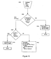
- the "folding back” logic is shown in Figure 10 and operates substantially the same as the logic of Figure 9 , with like steps being designated by the same reference number. A detailed discussion of the like steps is omitted.
- the difference in the "folding back” logic is that it looks back up the flight plan to find a duplicate of the first waypoint in a series of newly inserted waypoints (e.g. an arrival), Step S604. If a duplicate is found, for example, at Pos y , then the waypoints will be marked as "removed” from Pos y to Pos x-1 , Step S612.
- the logic of Figures 9 and 10 is also used in other flight plan operations when inserting a procedure in a single operation of Step S502, for example, when adding a terminal procedure.
- the flight plan will be searched forward from the last waypoint or backwards from the first waypoint that is entered in the series.
- a procedure is a series of waypoints that can be handled as a group. Whenever a procedure is selected in the modified flight plan, the old modified waypoints for the selected procedure will be removed and the new ones will be added. If the waypoints were part of the original flight plan procedure, they will be retained and marked as “removed.” If there are "removed" waypoints already representing the new procedure, then the "removed" designation will be cleared.
- the approach C G H is added after the last waypoint F, Step S502.
- An interim textlist of the logic includes waypoints A B C D E F C G H .
- the first waypoint in the approach (C) is a duplicate of a previous waypoint at Pos y , Step S604, that is not marked as "removed,” Step S508.
- the waypoints from Pos y to Pos x-1 are marked as "removed,” Step S612.
- the textlist of the logic looks like: A B C G H .
- the textlist includes the waypoints shown above and allows comparison of the performance data for the modified and original flight plans. Once the modified flight plan is activated to become the new flight plan, waypoints C, D, E, and F are removed, and the textlist then includes waypoints A B C G H.
- the Logic of Figures 9 and 10 can also be adapted for a modified flight plan that only removes waypoints. For example, if the original flight plan includes waypoints A B C D and waypoint C is selected to be removed, then, as in Step S512, waypoint C would be marked as removed.
- the modified textlist would then show waypoints A B C D and would allow comparison of the original flight plan and modified flight plan constraints and performance data. The same operation would apply if several waypoints were being removed, for example, if it is desired to bypass several waypoints by flying direct to a waypoint in the flight plan.
- the preferred method for producing the textlist is to merge two flight plans, such as the original and modified flight plans, to form the textlist. Any waypoints in the original flight plan that are not in the modified flight plan will be marked “removed” in the textlist, and any waypoints that are new in the modified flight plan and not in the original flight plan will be marked as "added.”
- the textlist is rebuilt after each edit operation such as a waypoint or procedure insertion.
- the logic produces a textlist that shows waypoints that have been "added” in the modified flight plan, as well as waypoints that are "removed” from the original flight plan.
- the constraints and performance data for the two flight plans can then be simultaneously displayed and compared.
- a flight plan change is initiated on the original flight plan, the original flight plan is copied into the modified flight plan.
- Each modified waypoint is assigned a new ID and a CopyID.
- a CopyID is a copy of the original flight plan's waypoint ID from which the modified waypoint was copied.
- the use of a CopyID allows identification of the location of the waypoint in the original flight plan, even if the waypoint occurs more than once in the flight plan.
- Figure 11 shows the logic for merging the original and modified flight plans into a textlist.
- An "index" is the position of a waypoint in a flight plan.
- the OriginalIndex and the ModifiedIndex correspond to the position where a waypoint action is currently being processed in the original and modified flight plans, respectively.
- the WptM odifiedIndex is the waypoint in the modified flight plan located at the modified index.
- the MatchIndex is the location in the original flight plan where the Wpt ModifiedIndex is found by searching forward from the OriginalIndex. At the MatchIndex, the CopyID of the Wpt ModifiedIndex in the modified flight plan equals the ID of the Wpt MatchIndex in the original flight plan.
- Step S702 the Matchlndex, OriginalIndex, and ModifiedIndex equal zero.
- Step S704 the Wpt ModifiedIndex , i.e., the waypoint located at the position ModifiedIndex, is obtained from the modified flight plan.
- Step S706 it is determined if the Wpt ModifiedIndex has a valid CopyID, i.e., whether it was copied from the original flight plan. If it does not have a valid CopyID, then it has been "added" to the modified flight plan, and it is added directly to the textlist, Step S708. If there is a CopyID, then the process proceeds to Step S710, where the original flight plan is searched to find the location of the matching waypoint. The search of the original flight plan begins at the Wpt OriginalIndex and searches forward until the location of the matching waypoint is found (i.e., the MatchIndex is found).
- Step S712 it is determined if the MatchIndex equals the OriginalIndex (i.e., whether the location of the matching waypoint is in the same relative location in both the original and modified flight plans). If yes, then the waypoint is added to the textlist, and the OriginalIndex is incremented by one, Step S716. The process then proceeds to Step S 718, where the ModifiedIndex is incremented by one. If the answer in Step S712 is no, then there are waypoints in the original flight plan from the OriginalIndex down to the matching waypoint. These waypoints are added to the textlist and marked as "removed," Step S714.
- Step S714 the matching waypoint (WPt ModifiedIndex ) is added to the textlist, and the OriginalIndex is set to equal the ModifiedIndex plus one.
- the process then proceeds to Step S718, where the ModifiedIndex is incremented by one.
- Step S720 it is determined whether there are any waypoints left in the modified flight plan to process. If so, then the process returns to Step S704 to analyze the next waypoint in the modified flight plan. If not, then the process proceeds to Step S722, where all remaining waypoints in the original flight plan are added to the textlist and are marked as "removed.” In Step S724, the process returns to Step S702 to wait the beginning of a new merge process.
- each waypoint in the modified flight plan is compared to the original flight plan.
- the textlist is rebuilt to show the common waypoints on both flight plans, waypoints on the original flight plan that are designated to be removed, and additional waypoints that are only on the modified flight plan. Comparison data can then be provided for the common waypoints, and data for the added waypoints can also be provided.
- Procedure section names can be compared to determine if procedure sections have been changed. This can be used to display a removed procedure as a section name, e.g., rather than as a series of "removed" waypoints.
- an original flight plan includes waypoints LL07, INW, GCN, PGS, BLD, KLAS, BTY, BIH, FRA, HYP, MOD, and KSFO.
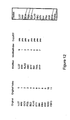
- each waypoint is copied into the modified flight plan and is assigned a CopyID corresponding to its original flight plan counterpart ( Figure 12 indicates which waypoints from the modified flight plan have a CopyID).
- the modified flight plan shown in Figure 12 includes waypoints LL07, INW, KLAS, ABC, BTY, BIH, FRA, and HYP.
- Figure 12 also shows the position of the waypoints in the original and modified flight plans, which correspond to the OriginalIndex position and ModifiedIndex position, respectively.
- Step S702 the process starts at index position 0 in the original and modified flight plans.
- Step S704 the first waypoint LL07 at position ModifiedIndex 0 is obtained from the modified flight plan.
- Step S706 it is determined that LL07 has a CopyID, indicating that it originated from the original flight plan (i.e., LL07 has a matching waypoint in the original flight plan).
- the process proceeds to Step S710 to obtain the MatchIndex, which corresponds to the position of the matching waypoint in the original flight plan.
- the MatchIndex for LL07 in the original flight plan is 0, because LL07 is located at index position 0.
- the OriginalIndex for LL07 is also 0, as mentioned earlier.
- Step S712 it is determined that the MatchIndex equals the OriginalIndex, and the process proceeds to Step S716, where waypoint LL07 is added to the textlist, and the OriginalIndex is incremented to position 1.
- Step S720 it is determined that all waypoints in the modified flight plan have not been processed, and the process returns to Step S704.
- Step S704 the next waypoint in the modified flight plan is obtained, i.e., the waypoint INW at ModifiedIndex 1 is obtained.
- the process for INW is identical to that of LL07, and a detailed discussion is omitted.
- Step S706 it is determined that KLAS has a CopyID, indicating that it originated from the original flight plan (i.e., KLAS has a matching waypoint in the original flight plan).
- the process proceeds to Step S710 to obtain the MatchIndex, which corresponds to the position of the matching waypoint in the original flight plan.
- the Matchlndex for KLAS in the original flight plan is 5, because KLAS is located at index position 5.
- the OriginalIndex is set to 2.
- Step S712 it is determined that the MatchIndex and the OriginalIndex are not equal, and the process proceeds to Step S714.
- Step S714 waypoints from the OriginalIndex to the MatchIndex-1 (i.e., GCN, PGS, and BLD) are added to the textlist and marked as "removed.” KLAS is also added to the textlist, and the OriginalIndex is set to the MatchIndex+1 (i.e., 6).
- Step S718 the ModifiedIndex is incremented to position 3.
- Step S720 it is determined that all waypoints in the modified flight plan have not been processed, and the process returns to Step S704.
- Step S704 ABC is obtained from position 3 of the modified flight plan.
- Step S706 it is determined that ABC does not have a CopyId, i.e., it did not originate from the original flight plan.
- the process proceeds to Step S708 where ABC is added to the textlist.
- the ModifiedIndex is incremented to 4, Step S718, and the process returns to Step S704 after it is determined in Step S720 that all modified waypoints have not been processed.
- the OriginalIndex is 6 and the ModifiedIndex is 4.
- Waypoints BTY, BIH, FRA, and HYP are processed and added to the textlist in a similar manner as waypoints LL07 and INW, and a description of their processing is omitted.
- Step S720 After HYP is processed, it is determined in Step S720 that all waypoints in the modified flight plan have been processed. The process then proceeds to Step S722 where the waypoints remaining in the original flight plan (i.e., MOD and KSFO) are added to the textlist and marked as "removed.” In Step S724, the process returns to Step S702 for the next editing procedure.
- the waypoints remaining in the original flight plan i.e., MOD and KSFO
- the systems, methods, and procedures described herein can be embodied in a programmable computer, computer executable software, or digital circuitry.
- the software can be stored on computer readable media, for example, on a floppy disk, RAM, ROM, a hard disk, removable media, flash memory, memory sticks, optical media, magneto-optical media, CD-ROMs, etc.
- the digital circuitry can include integrated circuits, gate arrays, building block logic, field programmable gate arrays (FPGA), etc.
Landscapes
- Engineering & Computer Science (AREA)
- Radar, Positioning & Navigation (AREA)
- Remote Sensing (AREA)
- Aviation & Aerospace Engineering (AREA)
- Physics & Mathematics (AREA)
- General Physics & Mathematics (AREA)
- Traffic Control Systems (AREA)
- Navigation (AREA)
- Control Of Indicators Other Than Cathode Ray Tubes (AREA)
- Circuits Of Receivers In General (AREA)
Claims (4)
- Système de navigation, comprenant :un dispositif d'affichage (304, 306) comportant une partie d'affichage graphique (306) et une partie d'affichage textuel (304) ; et caractérisé par :une logique (302) permettant l'exploitation de la partie d'affichage graphique et de la partie d'affichage textuel dudit dispositif d'affichage, ladite logique (302) présentant un affichage textuel d'un plan de vol d'origine et d'un plan de vol modifié dans la partie d'affichage textuel en présentant simultanément un affichage graphique du plan de vol d'origine et du plan de vol modifié sur la partie d'affichage graphique.
- Système de navigation selon la revendication 1, l'affichage textuel présenté par ladite logique (302) comprenant une liste textuelle de points de cheminement figurant sur le plan de vol d'origine et le plan de vol modifié, et des données de performances pour des points de cheminement communs figurant simultanément sur le plan de vol d'origine et le plan de vol modifié.
- Système de navigation selon la revendication 2, les données de performances pour chaque point de cheminement commun comprenant des données de performances pour le point de cheminement figurant sur le plan de vol d'origine et pour le point de cheminement figurant sur le plan de vol modifié.
- Système de navigation selon la revendication 3, comprenant en outre :un dispositif d'interface (308, 310) permettant à un opérateur de changer le plan de vol modifié ;ladite logique (302) mettant à jour la liste textuelle de points de cheminement sur l'affichage textuel (304) lors d'un changement du plan de vol modifié, etladite logique mettant à jour les données de performances sur l'affichage textuel pou des points de cheminement communs lors d'un changement du plan de vol modifié.
Applications Claiming Priority (3)
| Application Number | Priority Date | Filing Date | Title |
|---|---|---|---|
| US09/680,280 US6922631B1 (en) | 2000-10-06 | 2000-10-06 | System and method for textually displaying an original flight plan and a modified flight plan simultaneously |
| US680280 | 2000-10-06 | ||
| PCT/US2001/042458 WO2002029363A2 (fr) | 2000-10-06 | 2001-10-02 | Systeme et procede pour l'affichage textuel simultane d'un plan de vol d'origine et d'un plan de vol modifie |
Publications (2)
| Publication Number | Publication Date |
|---|---|
| EP1322916A2 EP1322916A2 (fr) | 2003-07-02 |
| EP1322916B1 true EP1322916B1 (fr) | 2010-11-10 |
Family
ID=24730458
Family Applications (1)
| Application Number | Title | Priority Date | Filing Date |
|---|---|---|---|
| EP01977892A Expired - Lifetime EP1322916B1 (fr) | 2000-10-06 | 2001-10-02 | Systeme et procede pour l'affichage textuel simultane d'un plan de vol d'origine et d'un plan de vol modifie |
Country Status (5)
| Country | Link |
|---|---|
| US (1) | US6922631B1 (fr) |
| EP (1) | EP1322916B1 (fr) |
| AT (1) | ATE487924T1 (fr) |
| DE (1) | DE60143441D1 (fr) |
| WO (1) | WO2002029363A2 (fr) |
Families Citing this family (66)
| Publication number | Priority date | Publication date | Assignee | Title |
|---|---|---|---|---|
| US7640098B2 (en) | 2001-07-31 | 2009-12-29 | Stenbock & Everson, Inc. | Process for generating travel plans on the internet |
| US7831292B2 (en) * | 2002-03-06 | 2010-11-09 | Mako Surgical Corp. | Guidance system and method for surgical procedures with improved feedback |
| US20040059474A1 (en) | 2002-09-20 | 2004-03-25 | Boorman Daniel J. | Apparatuses and methods for displaying autoflight information |
| SE0300871D0 (sv) * | 2003-03-27 | 2003-03-27 | Saab Ab | Waypoint navigation |
| FR2855303B1 (fr) * | 2003-05-19 | 2005-08-05 | Airbus France | Dispositif et systeme d'affichage de secours d'un aeronef. |
| US20050049762A1 (en) * | 2003-08-26 | 2005-03-03 | Dwyer David B. | Integrated flight management and textual air traffic control display system and method |
| US7460029B2 (en) * | 2003-12-24 | 2008-12-02 | The Boeing Company | Systems and methods for presenting and obtaining flight control information |
| US7188007B2 (en) | 2003-12-24 | 2007-03-06 | The Boeing Company | Apparatuses and methods for displaying and receiving tactical and strategic flight guidance information |
| US7418319B2 (en) | 2004-03-31 | 2008-08-26 | The Boeing Company | Systems and methods for handling the display and receipt of aircraft control information |
| FR2870372B1 (fr) * | 2004-05-11 | 2006-08-18 | Thales Sa | Procede d'aide a la verification de la trajectoire d'un aeronef |
| US20060235768A1 (en) * | 2005-03-24 | 2006-10-19 | Sabre Inc.And Travelocity.Com Lp. | System, method, and computer program product for reducing the burden on inventory system by displaying product availability information for a range of parameters related to a product |
| FR2883964B1 (fr) * | 2005-04-04 | 2007-05-11 | Airbus France Sas | Systeme d'aide a la navigation au sol d'un avion sur un aeroport |
| US8078344B2 (en) * | 2005-04-21 | 2011-12-13 | Honeywell International Inc. | System and method for displaying the protected airspace associated with a circle-to-land maneuver |
| US7966122B2 (en) * | 2005-05-13 | 2011-06-21 | Flightview Inc. | System and method for flight plan data capture |
| FR2895074B1 (fr) * | 2005-12-21 | 2008-02-15 | Thales Sa | Moniteur fonctionnel pour systeme de gestion de vol |
| US8271150B2 (en) * | 2005-12-22 | 2012-09-18 | The Boeing Company | Methods and systems for displaying enroute moving maps |
| US7876238B2 (en) * | 2005-12-22 | 2011-01-25 | The Boeing Company | Methods and systems for displaying procedure information |
| FR2905480B1 (fr) | 2006-08-30 | 2011-03-25 | Thales Sa | Methode de changement de la route suivie par un aeronef, l'aeronef suivant initialement une trajectoire predefinie, la methode permettant un retour eventuel de l'aeronef sur la trajectoire predefinie. |
| FR2906048B1 (fr) * | 2006-09-19 | 2008-12-19 | Thales Sa | Procede et dispositif de modification d'un plan de vol et notamment d'une procedure de decollage pour un aeronef |
| FR2909460B1 (fr) * | 2006-12-05 | 2009-01-23 | Thales Sa | Procede de remplacement de segments dans une procedure de navigation aerienne |
| FR2909782A1 (fr) * | 2006-12-08 | 2008-06-13 | Thales Sa | Procede de filtrage selectif d'un plan de vol d'aeronef en fonction des besoins operationnels |
| FR2916841B1 (fr) * | 2007-05-29 | 2009-09-11 | Thales Sa | Procede d'elaboration d'un plan de vol d'aeronef |
| US7698026B2 (en) * | 2007-06-14 | 2010-04-13 | The Boeing Company | Automatic strategic offset function |
| FR2920232B1 (fr) * | 2007-08-22 | 2015-02-27 | Airbus France | Procede et dispositif d'aide au pilotage d'un avion |
| FR2921152B1 (fr) * | 2007-09-14 | 2010-03-12 | Thales Sa | Procede d'assistance de rejointe de plan de vol d'aeronef par interception d'un segment de vol proche de l'aeronef |
| CN101424537B (zh) * | 2007-10-30 | 2012-02-08 | 联发科技(合肥)有限公司 | 航点代码创建方法、导航启动方法以及其相关装置 |
| US20090125222A1 (en) * | 2007-11-13 | 2009-05-14 | Honeywell International, Inc. | Flight plan comparison system and method |
| FR2924833B1 (fr) * | 2007-12-07 | 2014-02-07 | Thales Sa | Selection manuelle de la reference active d'un plan de vol pour le guidage d'un aeronef |
| US8180562B2 (en) * | 2008-06-04 | 2012-05-15 | The Boeing Company | System and method for taxi route entry parsing |
| US20090319100A1 (en) * | 2008-06-20 | 2009-12-24 | Honeywell International Inc. | Systems and methods for defining and rendering a trajectory |
| US8285427B2 (en) * | 2008-07-31 | 2012-10-09 | Honeywell International Inc. | Flight deck communication and display system |
| USD602942S1 (en) * | 2008-08-05 | 2009-10-27 | Allgress, Inc. | Graphical user interface for portion of a display screen |
| US9245242B2 (en) * | 2008-08-15 | 2016-01-26 | Hewlett Packard Enterprise Development Lp | Aircraft status timeline |
| FR2938327B1 (fr) * | 2008-11-07 | 2010-12-10 | Thales Sa | Procede pour la determination de la vitesse d'un aeronef |
| US8386167B2 (en) | 2008-11-14 | 2013-02-26 | The Boeing Company | Display of taxi route control point information |
| US8321069B2 (en) * | 2009-03-26 | 2012-11-27 | Honeywell International Inc. | Methods and systems for reviewing datalink clearances |
| FR2943778B1 (fr) * | 2009-03-27 | 2015-04-10 | Thales Sa | Dispositif interactif de navigation |
| FR2945622B1 (fr) * | 2009-05-15 | 2012-04-27 | Thales Sa | Procede de rejointe a court terme d'un plan de vol en guidage radar d'un aeronef |
| FR2951005B1 (fr) * | 2009-10-02 | 2012-08-03 | Thales Sa | Procede et dispositif d'aide a la gestion de vol d'un aeronef recevant une clairance de controle |
| FR2953302B1 (fr) * | 2009-11-27 | 2012-08-10 | Thales Sa | Procede de planification, de calcul de trajectoire, de predictions et de guidage pour le respect d'une contrainte de temps de passage d'un aeronef |
| US20110137998A1 (en) * | 2009-12-04 | 2011-06-09 | Honeywell International Inc. | System and method for delivery of non-textual controller pilot data link communications (cpdlc) for pilot review |
| FR2954490B1 (fr) * | 2009-12-18 | 2016-01-15 | Thales Sa | Procede et systeme de gestion dynamique d'une procedure de vol d'un plan de vol d'un aeronef |
| FR2956763B1 (fr) * | 2010-02-24 | 2016-01-29 | Airbus Operations Sas | Systeme embarque a bord d'un aeronef en lien avec un plan de vol |
| US9410819B2 (en) * | 2011-08-02 | 2016-08-09 | The Boeing Company | Management system for aeronautical information |
| US9495883B2 (en) | 2011-08-02 | 2016-11-15 | Honeywell International Inc. | System and method for displaying a procedure to an aircrew member |
| US8793038B1 (en) * | 2011-12-14 | 2014-07-29 | Rockwell Collins, Inc. | Providing preview information to facilitate flight plan selection |
| US8756012B2 (en) | 2012-02-03 | 2014-06-17 | Honeywell International Inc. | System and method for displaying performance based range and time scales on a navigation display |
| US8965600B2 (en) * | 2012-07-26 | 2015-02-24 | Ge Aviation Systems, Llc | Method for displaying a flight plan |
| GB201222453D0 (en) * | 2012-10-05 | 2013-01-23 | Airbus Operations Ltd | System and method for maximizing displaying of trajectory elements in an edit area of a navigational display of a cockpit display system |
| US9260197B2 (en) * | 2012-11-14 | 2016-02-16 | The Boeing Company | Systems and methods for displaying in-flight navigation procedures |
| FR2999700B1 (fr) * | 2012-12-14 | 2015-07-10 | Thales Sa | Procede et dispositif pour fournir sur une interface homme machine les donnees relatives a un plan de vol |
| US9448702B2 (en) | 2013-05-08 | 2016-09-20 | Honeywell International Inc. | Methods and systems for selecting a displayed aircraft approach or departure |
| CN103488179A (zh) * | 2013-09-18 | 2014-01-01 | 航天科工深圳(集团)有限公司 | 无人机飞行模拟系统及模拟方法 |
| USD746747S1 (en) * | 2013-09-26 | 2016-01-05 | Rockwell Collins, Inc. | Flight control panel |
| FR3020706B1 (fr) * | 2014-04-30 | 2017-10-06 | Airbus Operations Sas | Procede et dispositif de comparaison automatique de deux trajectoires de vol pour un aeronef. |
| FR3022354B1 (fr) * | 2014-06-16 | 2016-07-15 | Thales Sa | Procede de prediction d'une trajectoire court terme d'un aeronef, produit programme d'ordinateur, disponible de prediction, procede de guidage, systeme de guidage et aeronef associes |
| FR3023644B1 (fr) | 2014-07-11 | 2016-07-01 | Thales Sa | Procede d'insertion d'un troncon de plan de vol dans un plan de vol |
| US10204430B2 (en) * | 2015-11-03 | 2019-02-12 | Honeywell International Inc. | Aircraft systems and methods with enhanced CPDLC message management |
| US10876857B1 (en) * | 2019-10-30 | 2020-12-29 | Honeywell International Inc. | Wake vortex display system |
| FR3105870B1 (fr) * | 2019-12-27 | 2022-04-01 | Thales Sa | Dispositif électronique de génération d’un plan de vol pour un aéronef, procédé de génération et produit programme ordinateur associés |
| FR3105871B1 (fr) | 2019-12-27 | 2022-10-14 | Thales Sa | Procede d'aide a la verification d'au moins un plan de vol, produit programme d'ordinateur et module d'aide a la verification d'au moin un plan de vol associes |
| ES3057527T3 (en) * | 2021-08-19 | 2026-03-03 | Merlin Labs Inc | Advanced flight processing system and/or method |
| US12125393B2 (en) * | 2022-01-05 | 2024-10-22 | Honeywell International Inc. | Systems and methods to corroborate an externally recommended flight plan change with flight management system |
| US12354485B2 (en) * | 2022-03-07 | 2025-07-08 | The Boeing Company | Systems and methods for monitoring a flight plan of an aircraft |
| US12482362B2 (en) * | 2022-03-07 | 2025-11-25 | The Boeing Company | Systems and methods for monitoring a flight plan of an aircraft |
| US12573309B2 (en) | 2022-10-11 | 2026-03-10 | Merlin Labs, Inc. | System and/or method for pilot attention monitoring |
Family Cites Families (47)
| Publication number | Priority date | Publication date | Assignee | Title |
|---|---|---|---|---|
| US3267263A (en) | 1962-11-29 | 1966-08-16 | Carlton J Nelson | Navigational computer-display apparatus |
| US3652837A (en) | 1969-05-13 | 1972-03-28 | Butler National Corp | Automatic waypoint |
| US3883861A (en) | 1973-11-12 | 1975-05-13 | Gen Electric | Digital data base generator |
| US4086632A (en) * | 1976-09-27 | 1978-04-25 | The Boeing Company | Area navigation system including a map display unit for establishing and modifying navigation routes |
| US4339751A (en) | 1978-04-25 | 1982-07-13 | Raytheon Company | Marine radar including anticollision unit |
| US4413322A (en) | 1980-12-17 | 1983-11-01 | Foster Airdata Systems Inc. | Automatic waypoint area navigation system |
| US4642775A (en) * | 1984-05-25 | 1987-02-10 | Sundstrand Data Control, Inc. | Airborne flight planning and information system |
| US4692869A (en) | 1985-03-28 | 1987-09-08 | The Boeing Company | Aircraft navigational systems and methods for creating navigational guidepoints |
| DE3519276A1 (de) | 1985-05-30 | 1986-12-04 | Robert Bosch Gmbh, 7000 Stuttgart | Navigationssystem fuer fahrzeuge |
| US4825374A (en) | 1985-12-20 | 1989-04-25 | The Boeing Company | Aircraft descent guide system and method for creating descent guidance information |
| US4796190A (en) | 1986-06-04 | 1989-01-03 | Cummings Elihu C | Navigation system |
| US4994974A (en) | 1986-06-04 | 1991-02-19 | Cummings Elihu C | Touch sensitive navigation system |
| US4827419A (en) | 1986-09-22 | 1989-05-02 | Lasertrak Corporation | Portable navigational planning device |
| US4893127A (en) | 1987-02-06 | 1990-01-09 | Raytheon Company | Radar navigation system |
| US4812990A (en) | 1987-04-29 | 1989-03-14 | Merit Technology Incorporated | System and method for optimizing aircraft flight path |
| US4857902A (en) | 1987-05-14 | 1989-08-15 | Advanced Interaction, Inc. | Position-dependent interactivity system for image display |
| US5057835A (en) | 1987-10-28 | 1991-10-15 | Eventide, Inc. | Map and text display system for vehicle navigation |
| US5072218A (en) | 1988-02-24 | 1991-12-10 | Spero Robert E | Contact-analog headup display method and apparatus |
| US4891761A (en) | 1988-03-31 | 1990-01-02 | Mets, Inc. | Method for accurately updating positional information provided on a digital map |
| JPH0227218A (ja) | 1988-07-18 | 1990-01-30 | Aisin Aw Co Ltd | ナビゲーション装置における距離誤差修正方法 |
| US4939661A (en) | 1988-09-09 | 1990-07-03 | World Research Institute For Science And Technology | Apparatus for a video marine navigation plotter with electronic charting and methods for use therein |
| US5268844A (en) | 1989-03-06 | 1993-12-07 | Carver Christopher S | Electronic digital position and navigational plotter |
| EP0388174A3 (fr) | 1989-03-14 | 1991-07-31 | Invention Factory (Proprietary) Limited | Aide pour la navigation |
| US4999782A (en) | 1989-05-03 | 1991-03-12 | Honeywell Inc. | Fixed curved path waypoint transition for aircraft |
| US5047946A (en) | 1989-09-21 | 1991-09-10 | The Boeing Company, Inc. | Aircraft navigational system and method for guiding an aircraft along intersecting airways |
| US5646854A (en) | 1989-11-14 | 1997-07-08 | Honeywell Inc. | Lateral guidance transition control apparatus for aircraft area navigation systems |
| US5220507A (en) | 1990-11-08 | 1993-06-15 | Motorola, Inc. | Land vehicle multiple navigation route apparatus |
| FR2677149B1 (fr) * | 1991-05-27 | 1994-02-04 | Sextant Avionique | Procede et dispositif pour la revision du plan de vol lateral d'un aerodyne. |
| US5179385A (en) | 1992-01-02 | 1993-01-12 | International Marine Industries, Inc. | Visual navigation aid with point of interest feature |
| FR2694392B1 (fr) | 1992-07-31 | 1994-10-07 | Sextant Avionique | Procédé d'assistance à la navigation. |
| JP3302445B2 (ja) | 1993-06-18 | 2002-07-15 | パイオニア株式会社 | ナビゲーション装置 |
| US5408413A (en) * | 1993-08-03 | 1995-04-18 | Honeywell Inc. | Apparatus and method for controlling an optimizing aircraft performance calculator to achieve time-constrained navigation |
| US5422814A (en) | 1993-10-25 | 1995-06-06 | Trimble Navigation Limited | Global position system receiver with map coordinate system outputs |
| US6321158B1 (en) | 1994-06-24 | 2001-11-20 | Delorme Publishing Company | Integrated routing/mapping information |
| FR2729480B1 (fr) | 1995-01-16 | 1997-04-04 | Sextant Avionique | Procede de pilotage d'un aerodyne par asservissement sur une trajectoire horizontale determinee a partir de points de passage |
| US5842142A (en) * | 1995-05-15 | 1998-11-24 | The Boeing Company | Least time alternate destination planner |
| US5715163A (en) * | 1995-08-22 | 1998-02-03 | The Boeing Company | Cursor controlled navigation system for aircraft |
| DE19604931A1 (de) * | 1996-02-10 | 1997-08-14 | Nfs Navigations Und Flugfuehru | Verfahren zur Korrektur des Flugablaufs eines Fluggerätes |
| US5797106A (en) * | 1996-03-29 | 1998-08-18 | The Boeing Company | Method and apparatus for an improved flight management system providing for linking of an outbound course line from a predetermined position with an existing flight plan |
| US5916297A (en) * | 1996-04-24 | 1999-06-29 | The Boeing Company | Method and apparatus for an improved flight management system providing for synchronization of control display units in an alternate navigation mode |
| KR100279366B1 (ko) | 1996-07-31 | 2001-01-15 | 모리 하루오 | 차량용네비게이션장치 |
| FR2752934B1 (fr) * | 1996-08-30 | 1998-11-13 | Sextant Avionique | Procede d'assistance au pilotage d'un aerodyne |
| US5995901A (en) | 1996-09-30 | 1999-11-30 | Rockwell International Corporation | Automatic view adjusting flight plan display |
| US6112141A (en) * | 1997-10-15 | 2000-08-29 | Dassault Aviation | Apparatus and method for graphically oriented aircraft display and control |
| US6314349B1 (en) | 1998-12-21 | 2001-11-06 | The United States Of America As Represented By The Secretary Of The Navy | Landmass fly-around boundary generation |
| US6314362B1 (en) | 1999-02-02 | 2001-11-06 | The United States Of America As Represented By The Administrator Of The National Aeronautics And Space Administration | Method and system for an automated tool for en route traffic controllers |
| US6134500A (en) * | 1999-06-03 | 2000-10-17 | United Air Lines, Inc. | System and method for generating optimal flight plans for airline operations control |
-
2000
- 2000-10-06 US US09/680,280 patent/US6922631B1/en not_active Expired - Lifetime
-
2001
- 2001-10-02 AT AT01977892T patent/ATE487924T1/de not_active IP Right Cessation
- 2001-10-02 DE DE60143441T patent/DE60143441D1/de not_active Expired - Lifetime
- 2001-10-02 EP EP01977892A patent/EP1322916B1/fr not_active Expired - Lifetime
- 2001-10-02 WO PCT/US2001/042458 patent/WO2002029363A2/fr not_active Ceased
Also Published As
| Publication number | Publication date |
|---|---|
| US6922631B1 (en) | 2005-07-26 |
| WO2002029363A3 (fr) | 2002-10-03 |
| ATE487924T1 (de) | 2010-11-15 |
| WO2002029363A2 (fr) | 2002-04-11 |
| DE60143441D1 (de) | 2010-12-23 |
| EP1322916A2 (fr) | 2003-07-02 |
Similar Documents
| Publication | Publication Date | Title |
|---|---|---|
| EP1322916B1 (fr) | Systeme et procede pour l'affichage textuel simultane d'un plan de vol d'origine et d'un plan de vol modifie | |
| EP1323151B1 (fr) | Procede et appareil logique d'affichage textuel simultane d'un plan de vol original et d'un plan de vol modifie | |
| US6542796B1 (en) | Methods and apparatus for integrating, organizing, and accessing flight planning and other data on multifunction cockpit displays | |
| US7493196B2 (en) | On-board flight management system for aircraft | |
| EP1649248B1 (fr) | Methode et systeme pour recapturer une route laterale au moyen d'un ordinateur de gestion de vol | |
| CA2199912C (fr) | Methode et appareillage d'un systeme de gestion de vol ameliore qui inserent dans un plan de vol existant une trajectoire de route exterieure a partir d'une position predeterminee. | |
| EP0929869B1 (fr) | Procede et appareil de gestion d'equipement electronique de bord | |
| JP4579540B2 (ja) | 航空機タキシー計画システム及び方法 | |
| US8914227B2 (en) | Method of generating an aircraft flight plan | |
| CN105599910B (zh) | 用于显示滑行许可的方法和系统 | |
| CN102737523B (zh) | 用于自动地管理飞行器的飞行计划的竖直轮廓的方法和装置 | |
| EP2410295A2 (fr) | Systèmes et procédé pour rechercher et afficher des plans de vol | |
| US20090306887A1 (en) | System and Method for Taxi Route Entry Parsing | |
| CN107192403A (zh) | 用于管理多目的地飞行计划的方法和系统 | |
| US10026327B2 (en) | Managing the trajectory of an aircraft in case of engine outage | |
| US6311125B1 (en) | Road selecting and editing using shortest path tree | |
| US20100250117A1 (en) | Device for Flight Plan Display with Displacement Based on Jumps | |
| CN1742277A (zh) | 飞机滑行规划系统和方法 | |
| US7698027B2 (en) | Aircraft path verification assistance method | |
| CN101228414B (zh) | 飞机的机场观察系统 | |
| CN110525670A (zh) | 管理飞行器的飞行剖面显示的方法和电子设备、电子系统 | |
| WO2007065775A1 (fr) | Systeme de gestion de la partie terminale d'un plan de vol | |
| JP2003130676A (ja) | 低高度飛行計画経路の作成方法および装置 | |
| JP2003130674A (ja) | 飛行管理方法および装置 | |
| US12315379B2 (en) | Automatic selection of an aircraft flight plan in the approach phase |
Legal Events
| Date | Code | Title | Description |
|---|---|---|---|
| PUAI | Public reference made under article 153(3) epc to a published international application that has entered the european phase |
Free format text: ORIGINAL CODE: 0009012 |
|
| 17P | Request for examination filed |
Effective date: 20030404 |
|
| AK | Designated contracting states |
Designated state(s): AT BE CH CY DE DK ES FI FR GB GR IE IT LI LU MC NL PT SE TR |
|
| 17Q | First examination report despatched |
Effective date: 20080729 |
|
| GRAP | Despatch of communication of intention to grant a patent |
Free format text: ORIGINAL CODE: EPIDOSNIGR1 |
|
| GRAS | Grant fee paid |
Free format text: ORIGINAL CODE: EPIDOSNIGR3 |
|
| GRAA | (expected) grant |
Free format text: ORIGINAL CODE: 0009210 |
|
| AK | Designated contracting states |
Kind code of ref document: B1 Designated state(s): AT BE CH CY DE DK ES FI FR GB GR IE IT LI LU MC NL PT SE TR |
|
| REG | Reference to a national code |
Ref country code: GB Ref legal event code: FG4D |
|
| REG | Reference to a national code |
Ref country code: CH Ref legal event code: EP |
|
| REG | Reference to a national code |
Ref country code: IE Ref legal event code: FG4D |
|
| REF | Corresponds to: |
Ref document number: 60143441 Country of ref document: DE Date of ref document: 20101223 Kind code of ref document: P |
|
| REG | Reference to a national code |
Ref country code: NL Ref legal event code: VDEP Effective date: 20101110 |
|
| PG25 | Lapsed in a contracting state [announced via postgrant information from national office to epo] |
Ref country code: AT Free format text: LAPSE BECAUSE OF FAILURE TO SUBMIT A TRANSLATION OF THE DESCRIPTION OR TO PAY THE FEE WITHIN THE PRESCRIBED TIME-LIMIT Effective date: 20101110 Ref country code: FI Free format text: LAPSE BECAUSE OF FAILURE TO SUBMIT A TRANSLATION OF THE DESCRIPTION OR TO PAY THE FEE WITHIN THE PRESCRIBED TIME-LIMIT Effective date: 20101110 Ref country code: SE Free format text: LAPSE BECAUSE OF FAILURE TO SUBMIT A TRANSLATION OF THE DESCRIPTION OR TO PAY THE FEE WITHIN THE PRESCRIBED TIME-LIMIT Effective date: 20101110 Ref country code: CY Free format text: LAPSE BECAUSE OF FAILURE TO SUBMIT A TRANSLATION OF THE DESCRIPTION OR TO PAY THE FEE WITHIN THE PRESCRIBED TIME-LIMIT Effective date: 20101110 Ref country code: PT Free format text: LAPSE BECAUSE OF FAILURE TO SUBMIT A TRANSLATION OF THE DESCRIPTION OR TO PAY THE FEE WITHIN THE PRESCRIBED TIME-LIMIT Effective date: 20110310 Ref country code: NL Free format text: LAPSE BECAUSE OF FAILURE TO SUBMIT A TRANSLATION OF THE DESCRIPTION OR TO PAY THE FEE WITHIN THE PRESCRIBED TIME-LIMIT Effective date: 20101110 |
|
| PG25 | Lapsed in a contracting state [announced via postgrant information from national office to epo] |
Ref country code: GR Free format text: LAPSE BECAUSE OF FAILURE TO SUBMIT A TRANSLATION OF THE DESCRIPTION OR TO PAY THE FEE WITHIN THE PRESCRIBED TIME-LIMIT Effective date: 20110211 |
|
| PG25 | Lapsed in a contracting state [announced via postgrant information from national office to epo] |
Ref country code: ES Free format text: LAPSE BECAUSE OF FAILURE TO SUBMIT A TRANSLATION OF THE DESCRIPTION OR TO PAY THE FEE WITHIN THE PRESCRIBED TIME-LIMIT Effective date: 20110221 Ref country code: BE Free format text: LAPSE BECAUSE OF FAILURE TO SUBMIT A TRANSLATION OF THE DESCRIPTION OR TO PAY THE FEE WITHIN THE PRESCRIBED TIME-LIMIT Effective date: 20101110 |
|
| PG25 | Lapsed in a contracting state [announced via postgrant information from national office to epo] |
Ref country code: DK Free format text: LAPSE BECAUSE OF FAILURE TO SUBMIT A TRANSLATION OF THE DESCRIPTION OR TO PAY THE FEE WITHIN THE PRESCRIBED TIME-LIMIT Effective date: 20101110 |
|
| PLBE | No opposition filed within time limit |
Free format text: ORIGINAL CODE: 0009261 |
|
| STAA | Information on the status of an ep patent application or granted ep patent |
Free format text: STATUS: NO OPPOSITION FILED WITHIN TIME LIMIT |
|
| 26N | No opposition filed |
Effective date: 20110811 |
|
| REG | Reference to a national code |
Ref country code: DE Ref legal event code: R097 Ref document number: 60143441 Country of ref document: DE Effective date: 20110811 |
|
| PG25 | Lapsed in a contracting state [announced via postgrant information from national office to epo] |
Ref country code: IT Free format text: LAPSE BECAUSE OF FAILURE TO SUBMIT A TRANSLATION OF THE DESCRIPTION OR TO PAY THE FEE WITHIN THE PRESCRIBED TIME-LIMIT Effective date: 20101110 |
|
| PG25 | Lapsed in a contracting state [announced via postgrant information from national office to epo] |
Ref country code: MC Free format text: LAPSE BECAUSE OF NON-PAYMENT OF DUE FEES Effective date: 20111031 |
|
| REG | Reference to a national code |
Ref country code: CH Ref legal event code: PL |
|
| PG25 | Lapsed in a contracting state [announced via postgrant information from national office to epo] |
Ref country code: DE Free format text: LAPSE BECAUSE OF NON-PAYMENT OF DUE FEES Effective date: 20120501 Ref country code: LI Free format text: LAPSE BECAUSE OF NON-PAYMENT OF DUE FEES Effective date: 20111031 Ref country code: CH Free format text: LAPSE BECAUSE OF NON-PAYMENT OF DUE FEES Effective date: 20111031 |
|
| REG | Reference to a national code |
Ref country code: IE Ref legal event code: MM4A |
|
| REG | Reference to a national code |
Ref country code: DE Ref legal event code: R119 Ref document number: 60143441 Country of ref document: DE Effective date: 20120501 |
|
| PG25 | Lapsed in a contracting state [announced via postgrant information from national office to epo] |
Ref country code: IE Free format text: LAPSE BECAUSE OF NON-PAYMENT OF DUE FEES Effective date: 20111002 |
|
| PG25 | Lapsed in a contracting state [announced via postgrant information from national office to epo] |
Ref country code: LU Free format text: LAPSE BECAUSE OF NON-PAYMENT OF DUE FEES Effective date: 20111002 |
|
| PG25 | Lapsed in a contracting state [announced via postgrant information from national office to epo] |
Ref country code: TR Free format text: LAPSE BECAUSE OF FAILURE TO SUBMIT A TRANSLATION OF THE DESCRIPTION OR TO PAY THE FEE WITHIN THE PRESCRIBED TIME-LIMIT Effective date: 20101110 |
|
| REG | Reference to a national code |
Ref country code: FR Ref legal event code: PLFP Year of fee payment: 16 |
|
| REG | Reference to a national code |
Ref country code: FR Ref legal event code: PLFP Year of fee payment: 17 |
|
| REG | Reference to a national code |
Ref country code: FR Ref legal event code: PLFP Year of fee payment: 18 |
|
| PGFP | Annual fee paid to national office [announced via postgrant information from national office to epo] |
Ref country code: FR Payment date: 20201027 Year of fee payment: 20 Ref country code: GB Payment date: 20201027 Year of fee payment: 20 |
|
| REG | Reference to a national code |
Ref country code: GB Ref legal event code: PE20 Expiry date: 20211001 |
|
| PG25 | Lapsed in a contracting state [announced via postgrant information from national office to epo] |
Ref country code: GB Free format text: LAPSE BECAUSE OF EXPIRATION OF PROTECTION Effective date: 20211001 |
|
| P01 | Opt-out of the competence of the unified patent court (upc) registered |
Effective date: 20230525 |