EP1455198A2 - Système de navigation hybride avec un réseau neuronal - Google Patents
Système de navigation hybride avec un réseau neuronal Download PDFInfo
- Publication number
- EP1455198A2 EP1455198A2 EP04251298A EP04251298A EP1455198A2 EP 1455198 A2 EP1455198 A2 EP 1455198A2 EP 04251298 A EP04251298 A EP 04251298A EP 04251298 A EP04251298 A EP 04251298A EP 1455198 A2 EP1455198 A2 EP 1455198A2
- Authority
- EP
- European Patent Office
- Prior art keywords
- gps
- tdoa
- neural network
- signal processor
- mobile terminal
- Prior art date
- Legal status (The legal status is an assumption and is not a legal conclusion. Google has not performed a legal analysis and makes no representation as to the accuracy of the status listed.)
- Granted
Links
Images



Classifications
-
- G—PHYSICS
- G01—MEASURING; TESTING
- G01S—RADIO DIRECTION-FINDING; RADIO NAVIGATION; DETERMINING DISTANCE OR VELOCITY BY USE OF RADIO WAVES; LOCATING OR PRESENCE-DETECTING BY USE OF THE REFLECTION OR RERADIATION OF RADIO WAVES; ANALOGOUS ARRANGEMENTS USING OTHER WAVES
- G01S19/00—Satellite radio beacon positioning systems; Determining position, velocity or attitude using signals transmitted by such systems
- G01S19/38—Determining a navigation solution using signals transmitted by a satellite radio beacon positioning system
- G01S19/39—Determining a navigation solution using signals transmitted by a satellite radio beacon positioning system the satellite radio beacon positioning system transmitting time-stamped messages, e.g. GPS [Global Positioning System], GLONASS [Global Orbiting Navigation Satellite System] or GALILEO
- G01S19/42—Determining position
- G01S19/48—Determining position by combining or switching between position solutions derived from the satellite radio beacon positioning system and position solutions derived from a further system
-
- G—PHYSICS
- G01—MEASURING; TESTING
- G01S—RADIO DIRECTION-FINDING; RADIO NAVIGATION; DETERMINING DISTANCE OR VELOCITY BY USE OF RADIO WAVES; LOCATING OR PRESENCE-DETECTING BY USE OF THE REFLECTION OR RERADIATION OF RADIO WAVES; ANALOGOUS ARRANGEMENTS USING OTHER WAVES
- G01S19/00—Satellite radio beacon positioning systems; Determining position, velocity or attitude using signals transmitted by such systems
- G01S19/01—Satellite radio beacon positioning systems transmitting time-stamped messages, e.g. GPS [Global Positioning System], GLONASS [Global Orbiting Navigation Satellite System] or GALILEO
-
- G—PHYSICS
- G01—MEASURING; TESTING
- G01S—RADIO DIRECTION-FINDING; RADIO NAVIGATION; DETERMINING DISTANCE OR VELOCITY BY USE OF RADIO WAVES; LOCATING OR PRESENCE-DETECTING BY USE OF THE REFLECTION OR RERADIATION OF RADIO WAVES; ANALOGOUS ARRANGEMENTS USING OTHER WAVES
- G01S5/00—Position-fixing by co-ordinating two or more direction or position line determinations; Position-fixing by co-ordinating two or more distance determinations
- G01S5/02—Position-fixing by co-ordinating two or more direction or position line determinations; Position-fixing by co-ordinating two or more distance determinations using radio waves
- G01S5/0257—Hybrid positioning
-
- G—PHYSICS
- G01—MEASURING; TESTING
- G01S—RADIO DIRECTION-FINDING; RADIO NAVIGATION; DETERMINING DISTANCE OR VELOCITY BY USE OF RADIO WAVES; LOCATING OR PRESENCE-DETECTING BY USE OF THE REFLECTION OR RERADIATION OF RADIO WAVES; ANALOGOUS ARRANGEMENTS USING OTHER WAVES
- G01S5/00—Position-fixing by co-ordinating two or more direction or position line determinations; Position-fixing by co-ordinating two or more distance determinations
- G01S5/02—Position-fixing by co-ordinating two or more direction or position line determinations; Position-fixing by co-ordinating two or more distance determinations using radio waves
- G01S5/0294—Trajectory determination or predictive filtering, e.g. target tracking or Kalman filtering
-
- G—PHYSICS
- G01—MEASURING; TESTING
- G01S—RADIO DIRECTION-FINDING; RADIO NAVIGATION; DETERMINING DISTANCE OR VELOCITY BY USE OF RADIO WAVES; LOCATING OR PRESENCE-DETECTING BY USE OF THE REFLECTION OR RERADIATION OF RADIO WAVES; ANALOGOUS ARRANGEMENTS USING OTHER WAVES
- G01S5/00—Position-fixing by co-ordinating two or more direction or position line determinations; Position-fixing by co-ordinating two or more distance determinations
- G01S5/02—Position-fixing by co-ordinating two or more direction or position line determinations; Position-fixing by co-ordinating two or more distance determinations using radio waves
- G01S5/06—Position of source determined by co-ordinating a plurality of position lines defined by path-difference measurements
-
- G—PHYSICS
- G06—COMPUTING OR CALCULATING; COUNTING
- G06N—COMPUTING ARRANGEMENTS BASED ON SPECIFIC COMPUTATIONAL MODELS
- G06N3/00—Computing arrangements based on biological models
- G06N3/02—Neural networks
-
- H—ELECTRICITY
- H04—ELECTRIC COMMUNICATION TECHNIQUE
- H04W—WIRELESS COMMUNICATION NETWORKS
- H04W64/00—Locating users or terminals or network equipment for network management purposes, e.g. mobility management
Definitions
- the present invention relates to navigation systems for locating mobile terminals in a mobile communication system; more particularly, a hybrid navigation systems using a neural network.
- a hybrid navigation system is a navigation system having a mixture of a global positioning system (GPS) using satellites and a radio localization system using a mobile communication network.
- GPS global positioning system
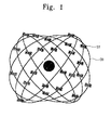
- Fig. 1 shows an arrangement of satellites for a global positioning system (GPS), a component of the hybrid navigation system.
- GPS global positioning system
- each group of four satellites ST is arranged on a circular orbital plane OB.
- a 3-dimensional position information and clock bias of a mobile terminal can be determined.
- the GPS receives radio waves including position information from the satellites. Then, the GPS measures an arrival time of the radio waves at a mobile terminal, and analyzes the position information to determine the position of the mobile terminal in real-time.
- a GPS generally utilizes the position information of the satellites, pseudo range, and a Kalman filter as an estimator for locating mobile terminals.
- a Kalman filter uses a system model comprising a state equation and a measuring equation describing movements of state variables in predicting movements. The Kalman filter estimates a state variable from the measurements. For example, future states are predicted using covariance of the errors between the predicted state variables and the measured values. In other words, the Kalman filter repeatedly performs processes of prediction and correction to minimize the covariance of the errors between the predicted values and the measured values.
- a GPS using a Kalman filter can provide fairly accurate position determination even with weak satellite signals. Moreover, a Kalman filter has good signal/noise separation and thus can prevent instantaneous jumps in position. Accordingly, position, velocity, and time can be determined. However, when a mobile terminal is at locations wherein not enough satellites are visible such as in case of a downtown area or indoors, the GPS may have difficulty in determining accurately the position of the mobile terminal, or at least requires a lengthy acquisition time period.
- a hybrid navigation system may be used.
- a hybrid system having a radio localization system and a mobile communication network.
- the radio localization system determines the position of the mobile terminal using the arrival time of signals between the stations and the mobile terminal, for example, by using time of arrival (TOA) of signals or by using a time difference of arrival (TDOA). Therefore, at least three or more stations capable of receiving signals generating from the mobile terminal are needed.
- TOA time of arrival
- TDOA time difference of arrival
- Fig. 2 shows a method for determining position using a radio determination system with TDOA.
- This system determines position of the mobile terminal using TOA of signals from different stations.
- the TOA of several signals is measured, which is proportional to the difference in distance between each of the two stations BS1 and BS2 and the mobile terminal MS.
- R1-R2 constant
- the localization signals of the TDOA system used for determining position are less susceptible to interferences of GPS signals in areas such as urban areas or indoors.
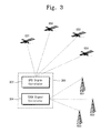
- a hybrid navigation system 300 such as shown in Fig. 3 has been proposed, including a GPS 302 and a TDOA system 304.
- the GPS 302 is used as the main navigation system and the TDOA system is used where the signals from satellites are weak or have been interfered with.
- the TDOA system is much less accurate than that of the GPS, largely due to a non line of sight (NLOS) and multi-path errors. Therefore, even the hybrid navigation system with both the GPS and TDOA system may not satisfy the condition of the E911 standard (i.e., Enhanced 911) prescribed by Federal communication commission (FCC).
- Enhanced 911 specifies that the probability that errors in tracking of users' positions are less than 100m is more than 67% in a network based radio determination system and the probability that the errors are less than 50m is more than 67%.
- the errors of the hybrid navigation system may be compensated for by a Kalman filter.
- the position values determined with the GPS or the TDOA system includes errors.
- Kalman filters can be based on a mathematical model having a dynamic equation of a hybrid navigation system and an error model.
- the position values have nonlinear dynamic characteristics, making difficult the deriavation of an accurate mathematical model.
- An improved hybrid navigation system which comprises a GPS signal processor, a TDOA signal processor and a neural network.
- the GPS signal processor receives GPS signals from satellites to detect positions of mobile terminal.
- the TDOA signal processor receives localization signals from mobile communication stations to determine positions of the mobile terminal.
- the neural network uses position values inputted from each of the GPS signal processor and the TDOA signal processor to learn and to predict the position of the mobile terminal.
- a hybrid navigation system comprises: a GPS signal processor for receiving GSP signals from satellites to determine positions of the mobile terminal; a TDOA signal processor for receiving localization signals from stations of the mobile communication system to determine positions of the mobile terminal; and a neural network for learning and predicting the positions of the mobile terminal based on signals received from the GPS signal processor and the TDOA signal processor, wherein the GPS processor is used to determine position of the mobile terminal when four or more GPS satellites are in view.
- the neural network corrects weights to learn position information, receiving position values determined with the GPS signal processor, position values determined with the TDOA signal processor and clock bias of a GPS receiver, and the position values determined with the GPS signal processor as a target value, wherein the neural network back propagates position values inputted by the GPS signal processor.
- neural network learns the position values inputted by the GPS signal processor in real time.
- the target value of the neural network is a position value estimated with a Kalman filter of the GPS signal processor.
- the TDOA signal processor predicts positions of the mobile terminal in case that the number of visible satellites is less than four, wherein the neural network receives the position values determined with the TDOA signal processor to predict positions of the mobile terminal by the learning process.
- a method of determining positions of a mobile terminal comprising: receiving position values determined with the GPS and the TDOA system; learning the determined position information by a neural network in case that the number of the GPS signal is four or more; estimating a present position of the mobile terminal with the GPS; and estimating positions of the mobile terminal with the TDOA system including the learned neural network in case that the number of the received GPS signals is less than four and the total number of the received GPS and TDOA signals is three or more; and initializing the GPS and the TDOA system in case that the total number of the received GPS and TDOA signals is less than three.
- the case that the number of the TDOA signals is three or more takes priority in the step of estimating the position of the mobile terminal with the TDOA system.
- the neural network learns by back-propagation.
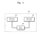
- Fig. 4 is a block diagram showing a hybrid navigation system including a neural network according to an embodiment of the present invention.
- the hybrid navigation system 400 comprises a GPS signal processor 402, a TDOA signal processor 404 and a neural network 406.
- the GPS signal processor 402 determines position of a mobile terminal by receiving GPS signals from satellites and the TDOA signal processor 404 determines position of a mobile terminal by receiving localization signals from mobile communication stations.
- the neural network 406 performs learning and prediction functions by using position values from the GPS signal processor 402 and the TDOA signal processor 404.
- the hybrid navigation system uses the GPS as the main navigation system to determine position, and the neural network learns the position values. If the GPS is unavailable, the hybrid navigation system uses the TDOA system. Then, the TDOA system uses the learned neural network for providing a more accurate position determination.
- the neural network analyzes problems using a learning process and controlling correlation between neurons to derive mathematical models (A neuron is a minimum unit composing a neural network). This process is similar to what a human does in learning and memorizing and performing the functions such as reasoning, classification, prediction, etc.
- the neural network is widely used in optimization and prediction and can be applied in various tasks for example, signal processing, voice recognition, robotics, navigation system, etc. In the neural network, probability of occurrence or statistics using past data is used to predict system operations.
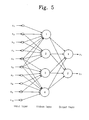
- Fig. 5 shows a conventional neural network including a hidden layer.
- the neural network comprises an input layer, a hidden layer and an output layer.
- the number of hidden layers and processing units of the neural network are not determined by specific rules but determined experimentally by trial and error. Generally, predictions are more accurate as the number of the hidden layers and the processing units is larger (i.e., as a degree of freedom of the neural network is larger), but the time needed for the neural network to learn becomes longer.
- the hybrid navigation system learns position information using a back propagation algorithm.
- An examplary back propagation algorithm is now described. First, weights of the neural network are initialized and then the position values introduced into an input layer are propagated through a hidden layer and an output layer. Next, target values set in the output layer are compared to the propagated output values to calculate errors of the output layer and errors of the hidden layer. Then, the weight of each layer is corrected considering the calculated errors. The process is repeated until there are no errors between the output values propagated by the neural network and the real target values.
- Fig. 6 is a diagram showing a preferred neural network according to the present invention.
- the neural network comprises five inputs, one hidden layer and three outputs.
- the hidden layer comprises six processing units.
- the neural network estimates present position values via a propagation process, receiving GPS position values (NG t-1 , EG t- 1) and position values of the TDOA system (NT t-1 , ET t-1 ), with respect to the positions at prior time, and clock bias values of a mobile terminal. Then, estimated present position values (Nt, Et) are compared to target values achieved with a Kalman filter of the GPS (i.e., position values determined by the GPS) to reach errors. Therefore, the errors are corrected by the reverse propagation algorithm to learn the neural network.
- the NG t-1 and EG t- 1 are coordinate values of the position determined at the prior time t-1 by the GPS in an NE coordinate system
- the NT t-1 and ET t-1 are coordinate values of the position determined by the TDOA system.
- the N t and E t are coordinate values of the present position that are estimated by the neural network.
- the position values determined by the TDOA system are used as inputs to carry out the propagation.
- Fig. 7 is a flow chart showing a process of a hybrid navigation system.
- the GPS is initialized together with a Kalman filter therein.
- positions of the GPS satellite and pseudo ranges are obtained by sensing and tracking GPS signals, and TDOA signals are sensed (in a step S702).
- TDOA signals are sensed (in a step S702).
- step S704 if the number of receivable GPS satellites in view is less than four (step S704), the position of mobile terminal cannot be determined with the GPS. In such case, the TDOA system is utilized to determine the position of the mobile terminal. Illustrative steps can be: first, it is judged whether the number of the TDOA signals is three or more (in a step S710); if the number of receivable TDOA signals is three or more, the TDOA system starts to measure positions of mobile terminal, and the learned neural network uses the measured position values to determine final position values (in a step S714).
- step S714 When the number of receivable TDOA signals is not three or more (in step S714), the total number of the received GPS signals and TDOA signals is judged (in a step S712). If the total number of receiving signals is three or more, the position of the mobile terminal is determined with the TDOA system using the learned neural network (step S714). If the total number of signals received in the step S712 is less than three, the GPS and TDOA systems are initialized and the position of the mobile terminal is predicted with only the previous resultant values by the neural network.
- the hybrid navigation system can mutually compensate for disadvantages of the GPS and TDOA system by way of a learning process of a neural network without building mathematical model with respect to nonlinear position values. As a result, the position of mobile terminal can be acquired accurately.
Landscapes
- Engineering & Computer Science (AREA)
- Radar, Positioning & Navigation (AREA)
- Remote Sensing (AREA)
- Physics & Mathematics (AREA)
- General Physics & Mathematics (AREA)
- Computer Networks & Wireless Communication (AREA)
- Theoretical Computer Science (AREA)
- Computational Linguistics (AREA)
- Molecular Biology (AREA)
- Artificial Intelligence (AREA)
- Biomedical Technology (AREA)
- Biophysics (AREA)
- Health & Medical Sciences (AREA)
- Data Mining & Analysis (AREA)
- Evolutionary Computation (AREA)
- General Health & Medical Sciences (AREA)
- Life Sciences & Earth Sciences (AREA)
- Computing Systems (AREA)
- General Engineering & Computer Science (AREA)
- Mathematical Physics (AREA)
- Software Systems (AREA)
- Signal Processing (AREA)
- Position Fixing By Use Of Radio Waves (AREA)
- Navigation (AREA)
Applications Claiming Priority (2)
| Application Number | Priority Date | Filing Date | Title |
|---|---|---|---|
| KR1020030014049A KR100591751B1 (ko) | 2003-03-06 | 2003-03-06 | 신경망을 이용한 복합 항법 시스템 및 신경망 적용 방법 |
| KR2003014049 | 2003-03-06 |
Publications (3)
| Publication Number | Publication Date |
|---|---|
| EP1455198A2 true EP1455198A2 (fr) | 2004-09-08 |
| EP1455198A3 EP1455198A3 (fr) | 2005-09-28 |
| EP1455198B1 EP1455198B1 (fr) | 2014-05-07 |
Family
ID=32822717
Family Applications (1)
| Application Number | Title | Priority Date | Filing Date |
|---|---|---|---|
| EP04251298.8A Expired - Lifetime EP1455198B1 (fr) | 2003-03-06 | 2004-03-05 | Système de navigation hybride avec un réseau neuronal |
Country Status (3)
| Country | Link |
|---|---|
| US (1) | US6919842B2 (fr) |
| EP (1) | EP1455198B1 (fr) |
| KR (1) | KR100591751B1 (fr) |
Cited By (10)
| Publication number | Priority date | Publication date | Assignee | Title |
|---|---|---|---|---|
| KR100754613B1 (ko) | 2004-11-11 | 2007-09-05 | 삼성전자주식회사 | Gps 방식 및 tdoa 방식을 통합한 이동단말의 위치추적방법 및 장치 |
| WO2008019172A3 (fr) * | 2006-03-06 | 2008-06-19 | Qualcomm Inc | méthode de détermination de la position avec des mesures ponctuelles |
| WO2008134572A1 (fr) | 2007-04-26 | 2008-11-06 | Qualcomm Incorporated | Suivi basé sur un emplacement |
| US8704707B2 (en) | 2010-06-02 | 2014-04-22 | Qualcomm Incorporated | Position determination using measurements from past and present epochs |
| US9074897B2 (en) | 2009-06-15 | 2015-07-07 | Qualcomm Incorporated | Real-time data with post-processing |
| CN108872932A (zh) * | 2018-05-03 | 2018-11-23 | 中国人民解放军战略支援部队信息工程大学 | 基于神经网络的超视距目标直接定位结果纠偏方法 |
| EP3688738A1 (fr) * | 2017-09-25 | 2020-08-05 | Continental Automotive Systems, Inc. | Localisation de véhicule à base de réseau neuronal |
| WO2020223908A1 (fr) * | 2019-05-07 | 2020-11-12 | Nokia Technologies Oy | Gestion de confidentialité |
| WO2021262570A1 (fr) * | 2020-06-23 | 2021-12-30 | Qualcomm Incorporated | Positionnement et télémétrie en liaison latérale ue-à-ue assistés par station de base avec formes d'onde prédéfinies |
| CN114280651A (zh) * | 2021-12-31 | 2022-04-05 | 中国测试技术研究院机械研究所 | 一种gnss定位方法、观测目标定位方法、微位移监控方法、定位装置、微位移监控装置 |
Families Citing this family (52)
| Publication number | Priority date | Publication date | Assignee | Title |
|---|---|---|---|---|
| KR20050117557A (ko) * | 2003-03-13 | 2005-12-14 | 메시네트웍스, 인코포레이티드 | 저속 중앙처리장치를 이용하는 무선 애드-혹 통신네트워크에 있어서 이동 가입자에 대한 위치계산의정확도를 향상시키기 위한 시스템 및 방법 |
| IL169408A (en) * | 2004-06-28 | 2010-02-17 | Northrop Grumman Corp | System for navigation redundancy |
| US7397424B2 (en) * | 2005-02-03 | 2008-07-08 | Mexens Intellectual Property Holding, Llc | System and method for enabling continuous geographic location estimation for wireless computing devices |
| US9392406B2 (en) | 2005-02-03 | 2016-07-12 | Trueposition, Inc. | Method and system for location-based monitoring of a mobile device |
| US8565788B2 (en) | 2005-02-03 | 2013-10-22 | Mexens Intellectual Property Holding Llc | Method and system for obtaining location of a mobile device |
| JP2006214933A (ja) * | 2005-02-04 | 2006-08-17 | Seiko Epson Corp | 測位システム、端末装置、端末装置の制御方法、端末装置の制御プログラム、端末装置の制御プログラムを記録したコンピュータ読み取り可能な記録媒体 |
| US7257412B2 (en) * | 2005-04-25 | 2007-08-14 | Mediatek Inc. | Methods and systems for location estimation |
| KR100648269B1 (ko) * | 2005-10-13 | 2006-11-23 | (주)래디안트 | 자기 학습 알고리즘을 통한 측위 향상을 위한 이동 통신단말기의 위치 결정 시스템 및 방법 |
| KR100701773B1 (ko) * | 2005-12-01 | 2007-03-30 | 에스케이 텔레콤주식회사 | Gps기능을 갖는 이동통신단말기의 위치 측정 방법 |
| US20070155489A1 (en) * | 2005-12-30 | 2007-07-05 | Frederic Beckley | Device and network enabled geo-fencing for area sensitive gaming enablement |
| US8150421B2 (en) * | 2005-12-30 | 2012-04-03 | Trueposition, Inc. | User plane uplink time difference of arrival (U-TDOA) |
| US20090005061A1 (en) * | 2005-12-30 | 2009-01-01 | Trueposition, Inc. | Location quality of service indicator |
| US8185129B2 (en) | 2006-07-07 | 2012-05-22 | Skyhook Wireless, Inc. | System and method of passive and active scanning of WLAN-enabled access points to estimate position of a WLAN positioning device |
| US7856234B2 (en) | 2006-11-07 | 2010-12-21 | Skyhook Wireless, Inc. | System and method for estimating positioning error within a WLAN-based positioning system |
| US8059028B2 (en) | 2008-08-14 | 2011-11-15 | Trueposition, Inc. | Hybrid GNSS and TDOA wireless location system |
| US8972177B2 (en) | 2008-02-26 | 2015-03-03 | Microsoft Technology Licensing, Llc | System for logging life experiences using geographic cues |
| US8015144B2 (en) * | 2008-02-26 | 2011-09-06 | Microsoft Corporation | Learning transportation modes from raw GPS data |
| US8966121B2 (en) * | 2008-03-03 | 2015-02-24 | Microsoft Corporation | Client-side management of domain name information |
| US20100090893A1 (en) * | 2008-10-09 | 2010-04-15 | Takayuki Hoshizaki | User based positioning aiding network by mobile GPS station/receiver |
| WO2010073057A1 (fr) * | 2008-12-23 | 2010-07-01 | Nokia Corporation | Procédé et appareil pour acquérir des informations concernant une position |
| TWI394976B (zh) * | 2008-12-24 | 2013-05-01 | Mstar Semiconductor Inc | 定位輔助方法以及使用該方法之定位輔助裝置 |
| US9063226B2 (en) | 2009-01-14 | 2015-06-23 | Microsoft Technology Licensing, Llc | Detecting spatial outliers in a location entity dataset |
| US8160610B2 (en) * | 2009-03-18 | 2012-04-17 | Andrew Llc | System and method for locating mobile device in wireless communication network |
| US9392521B2 (en) * | 2009-03-18 | 2016-07-12 | Telecommunication Systems, Inc. | System and method for concurrently determining locations of mobile device in wireless communication network |
| US8022877B2 (en) | 2009-07-16 | 2011-09-20 | Skyhook Wireless, Inc. | Systems and methods for using a satellite positioning system to detect moved WLAN access points |
| US9009177B2 (en) | 2009-09-25 | 2015-04-14 | Microsoft Corporation | Recommending points of interests in a region |
| US8013785B2 (en) * | 2009-12-31 | 2011-09-06 | Ntt Docomo, Inc. | Positioning system and positioning method |
| US8106817B2 (en) * | 2009-12-31 | 2012-01-31 | Polaris Wireless, Inc. | Positioning system and positioning method |
| US8106818B2 (en) * | 2009-12-31 | 2012-01-31 | Polaris Wireless, Inc. | Positioning system and positioning method |
| US9261376B2 (en) | 2010-02-24 | 2016-02-16 | Microsoft Technology Licensing, Llc | Route computation based on route-oriented vehicle trajectories |
| US10288433B2 (en) * | 2010-02-25 | 2019-05-14 | Microsoft Technology Licensing, Llc | Map-matching for low-sampling-rate GPS trajectories |
| US9182498B2 (en) * | 2010-03-31 | 2015-11-10 | Telenav Inc. | Hybrid navigation system with non-network update and method of operation thereof |
| US9541402B2 (en) | 2010-03-31 | 2017-01-10 | Telenav, Inc. | Hybrid navigation system with location based services and method of operation thereof |
| US9593957B2 (en) | 2010-06-04 | 2017-03-14 | Microsoft Technology Licensing, Llc | Searching similar trajectories by locations |
| US9754226B2 (en) | 2011-12-13 | 2017-09-05 | Microsoft Technology Licensing, Llc | Urban computing of route-oriented vehicles |
| US20130166188A1 (en) | 2011-12-21 | 2013-06-27 | Microsoft Corporation | Determine Spatiotemporal Causal Interactions In Data |
| KR101509135B1 (ko) * | 2014-02-10 | 2015-04-07 | 에이엠텔레콤주식회사 | 안심단말기에서 측위시간을 단축하는 방법 |
| CN104391314A (zh) * | 2014-12-11 | 2015-03-04 | 山东超越数控电子有限公司 | 一种WindowsCE系统下实现北斗/GPS组合导航的方法 |
| KR102203799B1 (ko) | 2017-09-18 | 2021-01-14 | 에스케이텔레콤 주식회사 | 단말 측위 장치 및 단말 측위 방법 |
| CN107949054A (zh) * | 2017-12-29 | 2018-04-20 | 清华大学 | 基于深度学习可见光室内高精度指纹定位方法 |
| CN108828519B (zh) * | 2018-05-24 | 2022-08-09 | 桂林电子科技大学 | 一种基于机器学习的高精度室内可见光定位方法 |
| CN109814101B (zh) * | 2019-01-25 | 2020-11-20 | 北京邮电大学 | 一种航空器位置预测的方法及装置 |
| CN109991564B (zh) * | 2019-02-26 | 2022-12-13 | 中国人民解放军战略支援部队信息工程大学 | 基于神经网络的短波单站定位结果纠偏方法 |
| KR102440457B1 (ko) * | 2019-11-26 | 2022-09-05 | 한국항공우주연구원 | 지구 관측 영상 전송 우선순위 결정 방법 및 장치 |
| KR102109488B1 (ko) * | 2019-12-03 | 2020-05-12 | (주)씨앤피에스 | 딥러닝을 이용한 고정밀 거리 측정 시스템 |
| KR102305048B1 (ko) * | 2019-12-29 | 2021-09-24 | 이원찬 | 인공지능을 이용한 센서위치보정시스템 |
| KR102372368B1 (ko) * | 2020-01-04 | 2022-03-07 | 이원찬 | 인공지능을 이용한 재난대응 피구조자 위치예측시스템 |
| CN111413719B (zh) * | 2020-03-21 | 2022-07-15 | 哈尔滨工程大学 | 一种基于神经网络的北斗实时精密时钟预测方法 |
| CN111947644B (zh) * | 2020-08-10 | 2022-04-12 | 北京洛必德科技有限公司 | 一种室外移动机器人定位方法、系统及其电子设备 |
| CN112859136B (zh) * | 2021-01-19 | 2022-03-25 | 腾讯科技(深圳)有限公司 | 一种定位方法和相关装置 |
| CN115825857A (zh) * | 2022-12-29 | 2023-03-21 | 亿航智能设备(广州)有限公司 | 一种无人机定位方法、装置及其设备 |
| CN116224378A (zh) * | 2023-03-13 | 2023-06-06 | 合肥工业大学 | 动态反向学习改进状态空间模型的北斗卫星信号干扰检测方法 |
Family Cites Families (5)
| Publication number | Priority date | Publication date | Assignee | Title |
|---|---|---|---|---|
| SE9302140L (sv) * | 1993-06-21 | 1994-08-29 | Televerket | Förfarande för lokalisering av mobilstationer i digitalt telenät |
| US5717406A (en) * | 1995-06-07 | 1998-02-10 | Sanconix Inc. | Enhanced position calculation |
| WO2001095642A2 (fr) * | 2000-06-02 | 2001-12-13 | Tracbeam Llc | Passerelle de localisation sans fil et application associee |
| US6148211A (en) * | 1997-09-05 | 2000-11-14 | Motorola, Inc. | Method and system for estimating a subscriber's location in a cluttered area |
| US20040075606A1 (en) * | 2002-10-22 | 2004-04-22 | Jaawa Laiho | Method and system for location estimation analysis within a communication network |
-
2003
- 2003-03-06 KR KR1020030014049A patent/KR100591751B1/ko not_active Expired - Fee Related
-
2004
- 2004-03-01 US US10/790,307 patent/US6919842B2/en not_active Expired - Lifetime
- 2004-03-05 EP EP04251298.8A patent/EP1455198B1/fr not_active Expired - Lifetime
Cited By (15)
| Publication number | Priority date | Publication date | Assignee | Title |
|---|---|---|---|---|
| KR100754613B1 (ko) | 2004-11-11 | 2007-09-05 | 삼성전자주식회사 | Gps 방식 및 tdoa 방식을 통합한 이동단말의 위치추적방법 및 장치 |
| US7446701B2 (en) * | 2004-11-11 | 2008-11-04 | Samsung Electronics Co., Ltd. | Method and apparatus for tracking location of user equipment by using integrated GPS and TDOA scheme |
| WO2008019172A3 (fr) * | 2006-03-06 | 2008-06-19 | Qualcomm Inc | méthode de détermination de la position avec des mesures ponctuelles |
| US9354321B2 (en) | 2006-03-06 | 2016-05-31 | Qualcomm Incorporated | Method for position determination with measurement stitching |
| WO2008134572A1 (fr) | 2007-04-26 | 2008-11-06 | Qualcomm Incorporated | Suivi basé sur un emplacement |
| US8019356B2 (en) | 2007-04-26 | 2011-09-13 | Qualcomm Incorporated | Location based tracking |
| US9074897B2 (en) | 2009-06-15 | 2015-07-07 | Qualcomm Incorporated | Real-time data with post-processing |
| US8704707B2 (en) | 2010-06-02 | 2014-04-22 | Qualcomm Incorporated | Position determination using measurements from past and present epochs |
| US10247828B2 (en) | 2010-06-02 | 2019-04-02 | Qualcomm Incorporated | Position determination using measurements from past and present epochs |
| EP3688738A1 (fr) * | 2017-09-25 | 2020-08-05 | Continental Automotive Systems, Inc. | Localisation de véhicule à base de réseau neuronal |
| CN108872932A (zh) * | 2018-05-03 | 2018-11-23 | 中国人民解放军战略支援部队信息工程大学 | 基于神经网络的超视距目标直接定位结果纠偏方法 |
| WO2020223908A1 (fr) * | 2019-05-07 | 2020-11-12 | Nokia Technologies Oy | Gestion de confidentialité |
| US12143811B2 (en) | 2019-05-07 | 2024-11-12 | Nokia Technologies Oy | Privacy management |
| WO2021262570A1 (fr) * | 2020-06-23 | 2021-12-30 | Qualcomm Incorporated | Positionnement et télémétrie en liaison latérale ue-à-ue assistés par station de base avec formes d'onde prédéfinies |
| CN114280651A (zh) * | 2021-12-31 | 2022-04-05 | 中国测试技术研究院机械研究所 | 一种gnss定位方法、观测目标定位方法、微位移监控方法、定位装置、微位移监控装置 |
Also Published As
| Publication number | Publication date |
|---|---|
| US6919842B2 (en) | 2005-07-19 |
| KR100591751B1 (ko) | 2006-06-22 |
| US20040174297A1 (en) | 2004-09-09 |
| EP1455198B1 (fr) | 2014-05-07 |
| KR20040079120A (ko) | 2004-09-14 |
| EP1455198A3 (fr) | 2005-09-28 |
Similar Documents
| Publication | Publication Date | Title |
|---|---|---|
| US6919842B2 (en) | Hybrid navigation system using neural network | |
| US7679561B2 (en) | Systems and methods for positioning using multipath signals | |
| US7257411B2 (en) | Selective fusion location estimation (SELFLOC) for wireless access technologies | |
| KR100749835B1 (ko) | 반송파 위상 gps 위치결정 장치 및 방법 | |
| US6414629B1 (en) | Tracking device | |
| US10422854B1 (en) | Neural network training for mobile device RSS fingerprint-based indoor navigation | |
| KR101108751B1 (ko) | 복수의 선택된 초기 위치 추정값을 사용하여 위치를결정하기 위한 방법 및 시스템 | |
| US6947880B2 (en) | Method for improving accuracy of a velocity model | |
| US10641610B1 (en) | Neural network—instantiated lightweight calibration of RSS fingerprint dataset | |
| US20110224824A1 (en) | Robot localization system | |
| CN116678421B (zh) | 基于多模块ble发射装置的多源融合定位方法及系统 | |
| US6535833B1 (en) | Method and apparatus for filtering measurements used in a generalized positioning system | |
| US10671921B1 (en) | Crowd-sourced training of a neural network for RSS fingerprinting | |
| US10655971B1 (en) | Maintaining a trained neural network for mobile device RSS fingerprint based indoor navigation | |
| EP4220233A1 (fr) | Procédé d'estimation de la position d'un dispositif | |
| JP2001201553A (ja) | 汎用位置決めシステム、およびハイブリッド位置決め機能をもった多重モデルナビゲーションフィルタ | |
| CN113063425B (zh) | 车辆定位方法、装置、电子设备及存储介质 | |
| KR102119196B1 (ko) | 머신러닝 기반의 실내 측위 방법 및 시스템 | |
| EP4141466B1 (fr) | Procédé de création d'un modèle de positionnement et procédé de positionnement | |
| WO2016196717A2 (fr) | Localisation mobile à l'aide de plages de temps de vol épars et d'une navigation à l'estime | |
| JP2681029B2 (ja) | Gps信号による位置決定方法およびその装置 | |
| Landau et al. | STEPS-indoor visual navigation framework for mobile devices. | |
| Hussain et al. | Hybrid technique to predict the position of Vehicle | |
| CN120821286A (zh) | 一种融合rtk与rssi的无人机导航方法及装置 | |
| RU2248669C2 (ru) | Способ определения местоположения абонентской мобильной станции |
Legal Events
| Date | Code | Title | Description |
|---|---|---|---|
| PUAI | Public reference made under article 153(3) epc to a published international application that has entered the european phase |
Free format text: ORIGINAL CODE: 0009012 |
|
| 17P | Request for examination filed |
Effective date: 20040326 |
|
| AK | Designated contracting states |
Kind code of ref document: A2 Designated state(s): AT BE BG CH CY CZ DE DK EE ES FI FR GB GR HU IE IT LI LU MC NL PL PT RO SE SI SK TR |
|
| AX | Request for extension of the european patent |
Extension state: AL HR LT LV MK |
|
| PUAL | Search report despatched |
Free format text: ORIGINAL CODE: 0009013 |
|
| AK | Designated contracting states |
Kind code of ref document: A3 Designated state(s): AT BE BG CH CY CZ DE DK EE ES FI FR GB GR HU IE IT LI LU MC NL PL PT RO SE SI SK TR |
|
| AX | Request for extension of the european patent |
Extension state: AL LT LV MK |
|
| AKX | Designation fees paid |
Designated state(s): DE GB |
|
| 17Q | First examination report despatched |
Effective date: 20110211 |
|
| RAP1 | Party data changed (applicant data changed or rights of an application transferred) |
Owner name: SAMSUNG ELECTRONICS CO., LTD. |
|
| REG | Reference to a national code |
Ref country code: DE Ref legal event code: R079 Ref document number: 602004045015 Country of ref document: DE Free format text: PREVIOUS MAIN CLASS: G01S0005140000 Ipc: G01S0019480000 |
|
| GRAP | Despatch of communication of intention to grant a patent |
Free format text: ORIGINAL CODE: EPIDOSNIGR1 |
|
| RIC1 | Information provided on ipc code assigned before grant |
Ipc: G01S 19/48 20100101AFI20131002BHEP Ipc: G01S 5/02 20100101ALN20131002BHEP |
|
| RIC1 | Information provided on ipc code assigned before grant |
Ipc: G01S 5/02 20100101ALN20131009BHEP Ipc: G01S 19/48 20100101AFI20131009BHEP |
|
| RIC1 | Information provided on ipc code assigned before grant |
Ipc: G01S 19/48 20100101AFI20131014BHEP Ipc: G01S 5/02 20100101ALN20131014BHEP |
|
| INTG | Intention to grant announced |
Effective date: 20131031 |
|
| GRAS | Grant fee paid |
Free format text: ORIGINAL CODE: EPIDOSNIGR3 |
|
| GRAA | (expected) grant |
Free format text: ORIGINAL CODE: 0009210 |
|
| AK | Designated contracting states |
Kind code of ref document: B1 Designated state(s): DE GB |
|
| REG | Reference to a national code |
Ref country code: GB Ref legal event code: FG4D |
|
| REG | Reference to a national code |
Ref country code: DE Ref legal event code: R096 Ref document number: 602004045015 Country of ref document: DE Effective date: 20140612 |
|
| REG | Reference to a national code |
Ref country code: DE Ref legal event code: R097 Ref document number: 602004045015 Country of ref document: DE |
|
| PLBE | No opposition filed within time limit |
Free format text: ORIGINAL CODE: 0009261 |
|
| STAA | Information on the status of an ep patent application or granted ep patent |
Free format text: STATUS: NO OPPOSITION FILED WITHIN TIME LIMIT |
|
| 26N | No opposition filed |
Effective date: 20150210 |
|
| REG | Reference to a national code |
Ref country code: DE Ref legal event code: R097 Ref document number: 602004045015 Country of ref document: DE Effective date: 20150210 |
|
| REG | Reference to a national code |
Ref country code: DE Ref legal event code: R119 Ref document number: 602004045015 Country of ref document: DE |
|
| GBPC | Gb: european patent ceased through non-payment of renewal fee |
Effective date: 20150305 |
|
| PG25 | Lapsed in a contracting state [announced via postgrant information from national office to epo] |
Ref country code: DE Free format text: LAPSE BECAUSE OF NON-PAYMENT OF DUE FEES Effective date: 20151001 Ref country code: GB Free format text: LAPSE BECAUSE OF NON-PAYMENT OF DUE FEES Effective date: 20150305 |
|
| P01 | Opt-out of the competence of the unified patent court (upc) registered |
Effective date: 20230520 |