EP1524191A1 - Flugführungsverfahren für den Landeanflug und zugehörige Bodenstation - Google Patents
Flugführungsverfahren für den Landeanflug und zugehörige Bodenstation Download PDFInfo
- Publication number
- EP1524191A1 EP1524191A1 EP04104852A EP04104852A EP1524191A1 EP 1524191 A1 EP1524191 A1 EP 1524191A1 EP 04104852 A EP04104852 A EP 04104852A EP 04104852 A EP04104852 A EP 04104852A EP 1524191 A1 EP1524191 A1 EP 1524191A1
- Authority
- EP
- European Patent Office
- Prior art keywords
- beacon
- aircraft
- information
- ground
- sbas
- Prior art date
- Legal status (The legal status is an assumption and is not a legal conclusion. Google has not performed a legal analysis and makes no representation as to the accuracy of the status listed.)
- Granted
Links
- 238000000034 method Methods 0.000 title claims abstract description 10
- 238000013459 approach Methods 0.000 claims abstract description 38
- 238000012937 correction Methods 0.000 claims abstract description 36
- 230000005540 biological transmission Effects 0.000 claims description 14
- 230000003416 augmentation Effects 0.000 claims description 12
- 101000972822 Homo sapiens Protein NipSnap homolog 2 Proteins 0.000 claims 2
- 102100022564 Protein NipSnap homolog 2 Human genes 0.000 claims 2
- 239000003550 marker Substances 0.000 abstract 1
- 230000000694 effects Effects 0.000 description 1
- 230000006870 function Effects 0.000 description 1
Images


Classifications
-
- B—PERFORMING OPERATIONS; TRANSPORTING
- B64—AIRCRAFT; AVIATION; COSMONAUTICS
- B64D—EQUIPMENT FOR FITTING IN OR TO AIRCRAFT; FLIGHT SUITS; PARACHUTES; ARRANGEMENT OR MOUNTING OF POWER PLANTS OR PROPULSION TRANSMISSIONS IN AIRCRAFT
- B64D45/00—Aircraft indicators or protectors not otherwise provided for
- B64D45/04—Landing aids; Safety measures to prevent collision with earth's surface
-
- G—PHYSICS
- G01—MEASURING; TESTING
- G01S—RADIO DIRECTION-FINDING; RADIO NAVIGATION; DETERMINING DISTANCE OR VELOCITY BY USE OF RADIO WAVES; LOCATING OR PRESENCE-DETECTING BY USE OF THE REFLECTION OR RERADIATION OF RADIO WAVES; ANALOGOUS ARRANGEMENTS USING OTHER WAVES
- G01S19/00—Satellite radio beacon positioning systems; Determining position, velocity or attitude using signals transmitted by such systems
- G01S19/01—Satellite radio beacon positioning systems transmitting time-stamped messages, e.g. GPS [Global Positioning System], GLONASS [Global Orbiting Navigation Satellite System] or GALILEO
- G01S19/03—Cooperating elements; Interaction or communication between different cooperating elements or between cooperating elements and receivers
- G01S19/07—Cooperating elements; Interaction or communication between different cooperating elements or between cooperating elements and receivers providing data for correcting measured positioning data, e.g. DGPS [differential GPS] or ionosphere corrections
-
- G—PHYSICS
- G01—MEASURING; TESTING
- G01S—RADIO DIRECTION-FINDING; RADIO NAVIGATION; DETERMINING DISTANCE OR VELOCITY BY USE OF RADIO WAVES; LOCATING OR PRESENCE-DETECTING BY USE OF THE REFLECTION OR RERADIATION OF RADIO WAVES; ANALOGOUS ARRANGEMENTS USING OTHER WAVES
- G01S19/00—Satellite radio beacon positioning systems; Determining position, velocity or attitude using signals transmitted by such systems
- G01S19/01—Satellite radio beacon positioning systems transmitting time-stamped messages, e.g. GPS [Global Positioning System], GLONASS [Global Orbiting Navigation Satellite System] or GALILEO
- G01S19/13—Receivers
- G01S19/14—Receivers specially adapted for specific applications
- G01S19/15—Aircraft landing systems
-
- G—PHYSICS
- G01—MEASURING; TESTING
- G01S—RADIO DIRECTION-FINDING; RADIO NAVIGATION; DETERMINING DISTANCE OR VELOCITY BY USE OF RADIO WAVES; LOCATING OR PRESENCE-DETECTING BY USE OF THE REFLECTION OR RERADIATION OF RADIO WAVES; ANALOGOUS ARRANGEMENTS USING OTHER WAVES
- G01S19/00—Satellite radio beacon positioning systems; Determining position, velocity or attitude using signals transmitted by such systems
- G01S19/38—Determining a navigation solution using signals transmitted by a satellite radio beacon positioning system
- G01S19/39—Determining a navigation solution using signals transmitted by a satellite radio beacon positioning system the satellite radio beacon positioning system transmitting time-stamped messages, e.g. GPS [Global Positioning System], GLONASS [Global Orbiting Navigation Satellite System] or GALILEO
- G01S19/40—Correcting position, velocity or attitude
- G01S19/41—Differential correction, e.g. DGPS [differential GPS]
Definitions
- the invention relates to a method for guiding an aircraft in approach phase and a ground beacon for the implementation of the method.
- the field of the invention is that of guiding an aircraft in approach phase.
- Final approach or precision approach is defined as the guidance phase during which the aircraft is brought along a trajectory predetermined and under clearly defined conditions of visibility at a certain height relative to the runway. This approach is Category 1 when the aircraft is brought to 200 feet, Category 2 when the aircraft is brought to 100 feet and Category 3 if the aircraft is brought to 50 feet or less, as shown in Figure 1.
- Ground tags can be GBAS ("Ground Based Augmentation System") tags or SBAS (Space Based Augmentation System).
- GBAS and SBAS systems are augmentation systems the positioning accuracy obtained by the GNSS system.
- SBAS-S satellites relay this SBAS signal from the station central to aircraft receivers.
- the receiver of the aircraft uses this SBAS signal to determine the integrity of its position and improve its precision.
- SBAS systems include: European Global Navigation Overlay Service (EGNOS), the North American WAAS system (Wide Aera Augmentation System).
- the "MMR" receiver on board the aircraft is able to receive the signals transmitted by the GBAS beacons as well as those issued by a central station SBAS-G and relayed by SBAS-S satellites.
- GBAS tags provide more accurate corrections than those of a SBAS central station.
- GBAS tags are under authority of the air traffic control service which can thus control the emission of these tags based on the integrity and accuracy of the position required.
- GBAS tags provide, in addition to corrections, Ideal Approach Path Information ("FAS").
- FAS Ideal Approach Path Information
- GBAS ground beacons are therefore used for final approaches, while SBAS-type stations ("Space Based Augmentation System "in English) are used for precision.
- the guidance is based on a trajectory ideal approach and the position of the aircraft in relation to this path. The closer the aircraft is to the runway, the more the position must be accurate and the integrity must be high.
- the MMR receiver receives radio-satellite signals from differential positioning of the GNSS system; he also receives, from tags, corrections applicable to these signals and information concerning the ideal trajectories.
- the aircraft crew selects the desired ideal course and then the receiver then calculates the guiding gap between this ideal trajectory and the corrected position of the aircraft. This guide gap is then transmitted to the autopilot that adjusts the flight path of the aircraft accordingly.
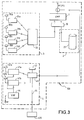
- a GBAS 100 ground beacon includes as represented in FIG. 3, a VHF transmitter 1 preceded by a formatting element 10, connected to a device 2 capable of providing the information of ideal trajectories (“FAS") that are issued by the issuer 1 in the form an M4 message; the formatting element 10 is also connected to a device 3 able to calculate the corrections that are issued by the transmitter 1 in the form of a message M1.
- FAS ideal trajectories
- the device 2 comprises a database 21 comprising the ideal trajectories of runways.
- the ideal trajectories are transmitted to the transmitter 1 after formatting.
- the device 3 comprises reference receivers able to receive radio-satellite signals of differential positioning of the GNSS system, in general 4 receivers 31a, 31b, 31c, 31d respectively equipped with their antennas 32a, 32b, 32c, 32d. Each reference receiver calculates corrections for all satellites in view.
- the device 3 also includes a calculator 33 which verifies these corrections and eliminates the outliers then calculates an average correction for all satellites. These corrections are then transmitted to the transmitter 1 after formatting.
- the beacon preferably also includes a control device 4 the transmission of messages M1 and M4, also called position monitor. It includes positioning radio-satellite signal receivers differential of the GNSS system, for example two receivers 41a and 41b respectively equipped with their antennas 42a and 42b and which determine the position of the beacon and a receiver VHF 44 of the message M1 comprising the corrections. These corrections are provided to receivers 41a and 41b which determine the corrected position of the beacon. Moreover, the position of the tag is known and stored in memory 47 in the tag. A calculator 43 calculates the difference between this known position and the corrected position so determine the integrity of the position calculation. Representative parameters of integrity are associated with the corrections in the M1 message in order to be also transmitted to the receiver of the aircraft.
- a control device 4 the transmission of messages M1 and M4, also called position monitor. It includes positioning radio-satellite signal receivers differential of the GNSS system, for example two receivers 41a and 41b respectively equipped with their antennas 42a and 42b and which determine the position of the
- This device 4 is connected to the air traffic control service 400 wire or radio: messages M1 and M4 are transmitted under the authority of this service. When the integrity is sufficient, that is to say is greater than one value determined by this service, messages M1 and M4 are issued by the transmitter 1; when not enough, a controlled switch by the computer 43 cuts the emission. This service can also decide to to cut the emission for example in case of wind, fog, .... even when integrity seems sufficient.
- This control device 4 preferably comprises more than one GNSS receiver on the one hand to enhance integrity and on the other hand to that in case of failure of one of the receivers, the other takes over.
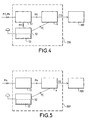
- An MMR 200 receiver on board the aircraft is schematically represented in FIG. reception of signals, among which, a device 51 for receiving GBAS signals M1 and M4, a device 52 for receiving signals from differential positioning GNSS able to receive further M1 corrections of the device 51 and to determine the corrected position of the aircraft, a calculator 6 which, from M4 provided by the device 51 and position corrected PC provided by the device 52, determines the guide gap EG and the transmits to the autopilot 300.
- This guidance deviation EG includes the deviation the vertical distance, the horizontal distance and the distance between the aircraft and the next obligatory passage.
- SBAS satellites have the same characteristics as GNSS satellites. This is why the SBAS signal receiving device 53 is part of the device 52 for receiving GNSS signals. These measures 53 SBAS signal reception is inactive in the final approach phase.
- the device 51 is inactive while the device 53 is active and the device 52 determines the corrected position from the GNSS signals and the SBAS signal containing corrections in the form of a message M1 'of a different format from that of M1. These corrections are almost the same as those from a GBAS tag.
- the device 52 then transmits the position corrected from the aircraft to the computer 6 which determines a guide deviation vertical.
- An important object of the invention is therefore to guide with respect to a final approach course, an aircraft located more than 200 feet use expensive ground tags.
- the invention also relates to a ground beacon for the implementation process of the method, comprising information storage means 21 on selected approach trajectories, formatting means 10 of this information in the form of a message M4, transmission means 1 of the message M4 on the same transmission channel as that of a beacon of a system for increasing the accuracy of the type positioning GBAS.
- Such a tag is obviously less expensive than that presented in the preamble and the correction information is transmitted in the form of a message M1 'by the central station SBAS which is already installed.
- the ground beacon comprises in in addition to reception means 42a, 42b of radio-satellite signals of differential positioning and reception of correction information from these radio-satellite signals, this information coming, via satellites SBAS, of a central station ground of a system of increase of the SBAS type positioning accuracy, means 41a, 41b for determine the corrected position of the beacon from radio-satellite signals and correction information, means 47 for storing the known position of the beacon, means 43 for determining the integrity of the position calculation according to the corrected position and the known position and means 43 for controlling the transmission of the beacon from the integrity.
- the MMR receiver onboard the airplane represented 5 has the same elements as those shown in FIG. operation differs from that described in relation to this figure: receiver 51 only receives the signals of type M4 emitted by a beacon simplified GBAS and transmits them as before to the calculator 6.
- the receiver 53 also active, receives via the SBAS satellites, signals SBAS including the position correction information and the device 52 determines the corrected position PC of the aircraft and transmits it to the according to this mode of operation of the MMR receiver, the receiving devices 51 and 53 operate simultaneously.
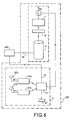
- the ground beacon 100 ' is a beacon of the GBAS type simplified, as shown in Figure 6. It does not have as represented in FIG. 3, the device 3 able to calculate the corrections that are transmitted by the transmitter 1 in the form of a message M1. It includes the device 2 capable of providing the information of ideal trajectories which are transmitted by the transmitter 1 in the form of a message M4. The message of M4 type is thus transmitted on the same VHF transmission channel as a classical GBAS beacon. The crew of the aircraft selects the trajectory desired, on instruction from the air traffic control service.
- the trajectory desired ideal is selected at the tag level on instruction of the ATM 400: the message M4 does not then include other trajectories.
- the instruction of the air traffic control service passes through a link 46 between the storage means 21 and the service 400. It may be a connection by wire or radio.
- Such a tag is obviously less expensive than that presented in the preamble and the correction information is transmitted in the form of a message M1 'by the central station SBAS which is already installed.
- This beacon 100 'advantageously comprises a device 4' of control of the transmission of the M4 message by the control service 400.
- This device 4 ' also called position monitor, is connected to the 400 air traffic control service by a 45 wire or radio link. He understands at least one receiver, for example two receivers 41a and 41b of signals radio-satellite differential positioning of the GNSS system and SBAS signals in the form of a message M1 ', the corrections transmitted by the SBAS central station via the SBAS satellites. These receivers are respectively provided with an antenna 42a and 42b. Each receiver 41a, 41b determines the corrected position of the beacon from the positioning signals and corrections. Moreover, the position of the tag is known and stored in memory in the tag.
- a calculator 43 calculate the difference between this known position and the corrected position in order to determine the integrity of the position calculation.
- integrity is sufficient, that is, when the representative parameters of integrity exceed one threshold determined by the air traffic control service, the message M4 is issued by the issuer 1; when not enough, a switch cuts transmission.
- the air traffic control service receives various parameters, including representative parameters of integrity. He can also decide to cut the emission for example in case of wind, fog, .... even when integrity seems sufficient. Finally the show can be cut automatically or by intervention of this service.
- the GNSS system can be the GPS system, the system GALILEO, the GLONASS system or any other positioning system by satellites.
- the aircraft is for example an airplane or a helicopter.
Landscapes
- Engineering & Computer Science (AREA)
- Radar, Positioning & Navigation (AREA)
- Remote Sensing (AREA)
- Computer Networks & Wireless Communication (AREA)
- Physics & Mathematics (AREA)
- General Physics & Mathematics (AREA)
- Aviation & Aerospace Engineering (AREA)
- Position Fixing By Use Of Radio Waves (AREA)
- Traffic Control Systems (AREA)
Applications Claiming Priority (2)
| Application Number | Priority Date | Filing Date | Title |
|---|---|---|---|
| FR0312185 | 2003-10-17 | ||
| FR0312185A FR2861051B1 (fr) | 2003-10-17 | 2003-10-17 | Procede de guidage d'un aeronef en phase d'approche et balise sol correspondante |
Publications (2)
| Publication Number | Publication Date |
|---|---|
| EP1524191A1 true EP1524191A1 (de) | 2005-04-20 |
| EP1524191B1 EP1524191B1 (de) | 2006-09-06 |
Family
ID=34355503
Family Applications (1)
| Application Number | Title | Priority Date | Filing Date |
|---|---|---|---|
| EP04104852A Expired - Lifetime EP1524191B1 (de) | 2003-10-17 | 2004-10-04 | Flugführungsverfahren für den Landeanflug und zugehörige Bodenstation |
Country Status (5)
| Country | Link |
|---|---|
| US (1) | US7218278B1 (de) |
| EP (1) | EP1524191B1 (de) |
| CA (1) | CA2484141C (de) |
| DE (1) | DE602004002257T2 (de) |
| FR (1) | FR2861051B1 (de) |
Cited By (4)
| Publication number | Priority date | Publication date | Assignee | Title |
|---|---|---|---|---|
| RU2373115C1 (ru) * | 2008-02-11 | 2009-11-20 | Общество с ограниченной ответственностью "Авиакомпания Волга-Днепр" | Устройство для предотвращения выкатывания воздушных судов за пределы взлетно-посадочной полосы |
| US7965227B2 (en) | 2006-05-08 | 2011-06-21 | Era Systems, Inc. | Aircraft tracking using low cost tagging as a discriminator |
| CN107562999A (zh) * | 2017-07-31 | 2018-01-09 | 上海宇航系统工程研究所 | 运载火箭固体发动机制导偏差仿真方法 |
| CN111309049A (zh) * | 2020-03-02 | 2020-06-19 | 中国人民解放军海军航空大学 | 一种微型飞行器的虚拟目标五米小幅高精度导引方法 |
Families Citing this family (21)
| Publication number | Priority date | Publication date | Assignee | Title |
|---|---|---|---|---|
| US8203486B1 (en) | 1999-03-05 | 2012-06-19 | Omnipol A.S. | Transmitter independent techniques to extend the performance of passive coherent location |
| US7570214B2 (en) | 1999-03-05 | 2009-08-04 | Era Systems, Inc. | Method and apparatus for ADS-B validation, active and passive multilateration, and elliptical surviellance |
| US8446321B2 (en) | 1999-03-05 | 2013-05-21 | Omnipol A.S. | Deployable intelligence and tracking system for homeland security and search and rescue |
| US7777675B2 (en) | 1999-03-05 | 2010-08-17 | Era Systems Corporation | Deployable passive broadband aircraft tracking |
| US7739167B2 (en) | 1999-03-05 | 2010-06-15 | Era Systems Corporation | Automated management of airport revenues |
| US7782256B2 (en) | 1999-03-05 | 2010-08-24 | Era Systems Corporation | Enhanced passive coherent location techniques to track and identify UAVs, UCAVs, MAVs, and other objects |
| US7667647B2 (en) | 1999-03-05 | 2010-02-23 | Era Systems Corporation | Extension of aircraft tracking and positive identification from movement areas into non-movement areas |
| US7612716B2 (en) | 1999-03-05 | 2009-11-03 | Era Systems Corporation | Correlation of flight track data with other data sources |
| US7889133B2 (en) | 1999-03-05 | 2011-02-15 | Itt Manufacturing Enterprises, Inc. | Multilateration enhancements for noise and operations management |
| US7908077B2 (en) | 2003-06-10 | 2011-03-15 | Itt Manufacturing Enterprises, Inc. | Land use compatibility planning software |
| FR2878953B1 (fr) * | 2004-12-03 | 2007-01-26 | Thales Sa | Architecture d'un systeme embarque d'aide au pilotage d'un aeronef |
| FR2980618A1 (fr) * | 2011-09-22 | 2013-03-29 | Airbus Operations Sas | Procede et systeme de determination d'une information de position d'un aeronef lors d'une approche d'une piste d'atterrissage. |
| US9069070B2 (en) | 2012-06-01 | 2015-06-30 | Honeywell International Inc. | Systems and methods for the selection of antennas in aircraft navigation systems |
| CN103991553B (zh) * | 2013-02-19 | 2016-02-24 | 成都海存艾匹科技有限公司 | 飞机精准着陆辅助装置 |
| US8928527B2 (en) * | 2013-03-19 | 2015-01-06 | Honeywell International Inc. | Systems and methods for reducing error detection latency in LPV approaches |
| JP6366357B2 (ja) * | 2014-05-16 | 2018-08-01 | 三菱電機株式会社 | 測位装置および測位方法 |
| US20160133138A1 (en) * | 2014-07-30 | 2016-05-12 | Aviation Communication & Surveillance Systems Llc | Systems and methods for helicopter situational awareness and landing assistance |
| US9470528B1 (en) * | 2015-03-26 | 2016-10-18 | Honeywell International Inc. | Aircraft synthetic vision systems utilizing data from local area augmentation systems, and methods for operating such aircraft synthetic vision systems |
| DE102017117501A1 (de) * | 2017-08-02 | 2019-02-07 | Airbus Defence and Space GmbH | Vorrichtung zum Prüfen der Konsistenz einer Positionsbestimmung |
| CN110599612B (zh) * | 2019-07-22 | 2023-01-13 | 广州南方卫星导航仪器有限公司 | 高速公路不停车自动收费的方法、设备、存储介质 |
| FR3099251B1 (fr) | 2019-07-24 | 2021-07-02 | Thales Sa | Procede de validation d'au moins une donnee de position predeterminee stockee au sein d'une base de donnees d'un aeronef, programme d'ordinateur et dispositif associes |
Citations (4)
| Publication number | Priority date | Publication date | Assignee | Title |
|---|---|---|---|---|
| US5786773A (en) * | 1996-10-02 | 1998-07-28 | The Boeing Company | Local-area augmentation system for satellite navigation precision-approach system |
| US6023239A (en) * | 1997-10-08 | 2000-02-08 | Arinc, Inc. | Method and system for a differential global navigation satellite system aircraft landing ground station |
| US6531981B1 (en) * | 2000-05-01 | 2003-03-11 | Skynetix, Llc | Global augmentation to global positioning system |
| DE10141595A1 (de) * | 2001-08-24 | 2003-03-13 | Guenter Blaschke | Hybride Instrumenten Landesysteme für Luftfahrzeuge |
-
2003
- 2003-10-17 FR FR0312185A patent/FR2861051B1/fr not_active Expired - Fee Related
-
2004
- 2004-10-04 EP EP04104852A patent/EP1524191B1/de not_active Expired - Lifetime
- 2004-10-04 DE DE602004002257T patent/DE602004002257T2/de not_active Expired - Fee Related
- 2004-10-07 CA CA2484141A patent/CA2484141C/fr not_active Expired - Lifetime
- 2004-10-12 US US10/961,376 patent/US7218278B1/en not_active Expired - Lifetime
Patent Citations (4)
| Publication number | Priority date | Publication date | Assignee | Title |
|---|---|---|---|---|
| US5786773A (en) * | 1996-10-02 | 1998-07-28 | The Boeing Company | Local-area augmentation system for satellite navigation precision-approach system |
| US6023239A (en) * | 1997-10-08 | 2000-02-08 | Arinc, Inc. | Method and system for a differential global navigation satellite system aircraft landing ground station |
| US6531981B1 (en) * | 2000-05-01 | 2003-03-11 | Skynetix, Llc | Global augmentation to global positioning system |
| DE10141595A1 (de) * | 2001-08-24 | 2003-03-13 | Guenter Blaschke | Hybride Instrumenten Landesysteme für Luftfahrzeuge |
Cited By (6)
| Publication number | Priority date | Publication date | Assignee | Title |
|---|---|---|---|---|
| US7965227B2 (en) | 2006-05-08 | 2011-06-21 | Era Systems, Inc. | Aircraft tracking using low cost tagging as a discriminator |
| RU2373115C1 (ru) * | 2008-02-11 | 2009-11-20 | Общество с ограниченной ответственностью "Авиакомпания Волга-Днепр" | Устройство для предотвращения выкатывания воздушных судов за пределы взлетно-посадочной полосы |
| CN107562999A (zh) * | 2017-07-31 | 2018-01-09 | 上海宇航系统工程研究所 | 运载火箭固体发动机制导偏差仿真方法 |
| CN107562999B (zh) * | 2017-07-31 | 2020-05-22 | 上海宇航系统工程研究所 | 运载火箭固体发动机制导偏差仿真方法 |
| CN111309049A (zh) * | 2020-03-02 | 2020-06-19 | 中国人民解放军海军航空大学 | 一种微型飞行器的虚拟目标五米小幅高精度导引方法 |
| CN111309049B (zh) * | 2020-03-02 | 2023-07-04 | 中国人民解放军海军航空大学 | 一种微型飞行器的虚拟目标五米小幅高精度导引方法 |
Also Published As
| Publication number | Publication date |
|---|---|
| FR2861051B1 (fr) | 2006-03-03 |
| US20070090993A1 (en) | 2007-04-26 |
| DE602004002257T2 (de) | 2007-04-05 |
| EP1524191B1 (de) | 2006-09-06 |
| FR2861051A1 (fr) | 2005-04-22 |
| US7218278B1 (en) | 2007-05-15 |
| CA2484141C (fr) | 2012-12-18 |
| DE602004002257D1 (de) | 2006-10-19 |
| CA2484141A1 (fr) | 2005-04-17 |
Similar Documents
| Publication | Publication Date | Title |
|---|---|---|
| EP1524191B1 (de) | Flugführungsverfahren für den Landeanflug und zugehörige Bodenstation | |
| ES2870669T3 (es) | Método y estación base de ADS-B para validar información de posición contenida en un mensaje de señales espontáneas ampliadas de modo S (ADS-B) desde una aeronave | |
| US7373223B2 (en) | Global navigation satellite system landing systems and methods | |
| US9830828B2 (en) | Systems and method for AIS transponder integration with ILS/VOR receivers | |
| US7164383B2 (en) | Navigation system using locally augmented GPS | |
| US7400292B2 (en) | GPS Navigation system with integrity and reliability monitoring channels | |
| US20060214844A1 (en) | Navigation system using external monitoring | |
| US20110231038A1 (en) | Aircraft landing system using relative gnss | |
| CA2337264C (fr) | Dispositif destine a ameliorer la securite des aeronefs en regime de vol a vue | |
| FR3044810A1 (fr) | Systeme d’aide a la gestion du vol d’un aeronef lors d’une phase d’atterrissage. | |
| FR2946173A1 (fr) | Procede et dispositif d'engagement d'un mode de pilotage automatique d'un aeronef. | |
| EP2367023B1 (de) | Système d'atterrissage d'avion au moyen de GNSS relative | |
| EP3688493B1 (de) | Verfahren zur verteilung und / oder aktualisierung einer flugverbotszonendatenbank für unbemannte luftfahrzeuge und fahrzeug dafür | |
| US20160340056A1 (en) | Precision guidance method and system for aircraft approaching and landing | |
| Gonzaga-López et al. | Implementing precision approaches supported by satellite-based augmentation systems in the Austrian alps | |
| FR2852685A1 (fr) | Procede et dispositif pour determiner au moins une information de position verticale d'un aeronef. | |
| US20250028060A1 (en) | Gnss spoofing detection and alert using sbas satellites | |
| EP4495634A1 (de) | Gnss-spoofing-detektion und -warnung unter verwendung von sbas-satelliten | |
| CA2697086C (en) | Aircraft landing system using relative gnss | |
| Ilčev | Global Satellite Augmentation Systems (GSAS) | |
| FR2934364A1 (fr) | Procede d'initialisation d'un systeme de navigation par satellite embarque dans un aeronef, et systeme associe | |
| FR3042047A1 (fr) | Procede et dispositif d'affichage sur un aeronef d'une image synthetique de l'environnement externe de l'aeronef. | |
| FR3122739A1 (fr) | Procédé de navigation avec recalage sur des aéronefs voisins | |
| Lee et al. | Availability of LAAS to Calibrate IRS for CAT IIIB | |
| Schaenzer et al. | Smart Airport Communication Navigation and Surveillance System Concepts |
Legal Events
| Date | Code | Title | Description |
|---|---|---|---|
| PUAI | Public reference made under article 153(3) epc to a published international application that has entered the european phase |
Free format text: ORIGINAL CODE: 0009012 |
|
| AK | Designated contracting states |
Kind code of ref document: A1 Designated state(s): AT BE BG CH CY CZ DE DK EE ES FI FR GB GR HU IE IT LI LU MC NL PL PT RO SE SI SK TR |
|
| AX | Request for extension of the european patent |
Extension state: AL HR LT LV MK |
|
| 17P | Request for examination filed |
Effective date: 20050625 |
|
| AKX | Designation fees paid |
Designated state(s): DE FR GB |
|
| GRAP | Despatch of communication of intention to grant a patent |
Free format text: ORIGINAL CODE: EPIDOSNIGR1 |
|
| GRAS | Grant fee paid |
Free format text: ORIGINAL CODE: EPIDOSNIGR3 |
|
| GRAA | (expected) grant |
Free format text: ORIGINAL CODE: 0009210 |
|
| AK | Designated contracting states |
Kind code of ref document: B1 Designated state(s): DE FR GB |
|
| REG | Reference to a national code |
Ref country code: GB Ref legal event code: FG4D Free format text: NOT ENGLISH |
|
| REF | Corresponds to: |
Ref document number: 602004002257 Country of ref document: DE Date of ref document: 20061019 Kind code of ref document: P |
|
| GBT | Gb: translation of ep patent filed (gb section 77(6)(a)/1977) |
Effective date: 20061211 |
|
| PLBE | No opposition filed within time limit |
Free format text: ORIGINAL CODE: 0009261 |
|
| STAA | Information on the status of an ep patent application or granted ep patent |
Free format text: STATUS: NO OPPOSITION FILED WITHIN TIME LIMIT |
|
| 26N | No opposition filed |
Effective date: 20070607 |
|
| PGFP | Annual fee paid to national office [announced via postgrant information from national office to epo] |
Ref country code: DE Payment date: 20070927 Year of fee payment: 4 |
|
| GBPC | Gb: european patent ceased through non-payment of renewal fee |
Effective date: 20081004 |
|
| PG25 | Lapsed in a contracting state [announced via postgrant information from national office to epo] |
Ref country code: DE Free format text: LAPSE BECAUSE OF NON-PAYMENT OF DUE FEES Effective date: 20090501 |
|
| PG25 | Lapsed in a contracting state [announced via postgrant information from national office to epo] |
Ref country code: GB Free format text: LAPSE BECAUSE OF NON-PAYMENT OF DUE FEES Effective date: 20081004 |
|
| REG | Reference to a national code |
Ref country code: FR Ref legal event code: PLFP Year of fee payment: 13 |
|
| REG | Reference to a national code |
Ref country code: FR Ref legal event code: PLFP Year of fee payment: 14 |
|
| REG | Reference to a national code |
Ref country code: FR Ref legal event code: PLFP Year of fee payment: 15 |
|
| PGFP | Annual fee paid to national office [announced via postgrant information from national office to epo] |
Ref country code: FR Payment date: 20201013 Year of fee payment: 17 |
|
| PG25 | Lapsed in a contracting state [announced via postgrant information from national office to epo] |
Ref country code: FR Free format text: LAPSE BECAUSE OF NON-PAYMENT OF DUE FEES Effective date: 20211031 |
|
| P01 | Opt-out of the competence of the unified patent court (upc) registered |
Effective date: 20230427 |