EP1571460A2 - Dispositif de détermination de position par satellite et méthode pour déterminer la position actuelle - Google Patents
Dispositif de détermination de position par satellite et méthode pour déterminer la position actuelle Download PDFInfo
- Publication number
- EP1571460A2 EP1571460A2 EP05250725A EP05250725A EP1571460A2 EP 1571460 A2 EP1571460 A2 EP 1571460A2 EP 05250725 A EP05250725 A EP 05250725A EP 05250725 A EP05250725 A EP 05250725A EP 1571460 A2 EP1571460 A2 EP 1571460A2
- Authority
- EP
- European Patent Office
- Prior art keywords
- satellites
- satellite
- designated
- positioning
- satellite positioning
- Prior art date
- Legal status (The legal status is an assumption and is not a legal conclusion. Google has not performed a legal analysis and makes no representation as to the accuracy of the status listed.)
- Granted
Links
- 238000000034 method Methods 0.000 title claims description 21
- 238000010790 dilution Methods 0.000 claims description 3
- 239000012895 dilution Substances 0.000 claims description 3
- 238000004590 computer program Methods 0.000 claims 2
- 231100000572 poisoning Toxicity 0.000 claims 1
- 230000000607 poisoning effect Effects 0.000 claims 1
- 238000013500 data storage Methods 0.000 description 3
- 238000010586 diagram Methods 0.000 description 3
- 230000000694 effects Effects 0.000 description 3
- 238000006073 displacement reaction Methods 0.000 description 2
- 230000001133 acceleration Effects 0.000 description 1
- 238000005352 clarification Methods 0.000 description 1
Images


Classifications
-
- G—PHYSICS
- G01—MEASURING; TESTING
- G01S—RADIO DIRECTION-FINDING; RADIO NAVIGATION; DETERMINING DISTANCE OR VELOCITY BY USE OF RADIO WAVES; LOCATING OR PRESENCE-DETECTING BY USE OF THE REFLECTION OR RERADIATION OF RADIO WAVES; ANALOGOUS ARRANGEMENTS USING OTHER WAVES
- G01S19/00—Satellite radio beacon positioning systems; Determining position, velocity or attitude using signals transmitted by such systems
- G01S19/01—Satellite radio beacon positioning systems transmitting time-stamped messages, e.g. GPS [Global Positioning System], GLONASS [Global Orbiting Navigation Satellite System] or GALILEO
- G01S19/13—Receivers
- G01S19/24—Acquisition or tracking or demodulation of signals transmitted by the system
- G01S19/28—Satellite selection
-
- G—PHYSICS
- G01—MEASURING; TESTING
- G01S—RADIO DIRECTION-FINDING; RADIO NAVIGATION; DETERMINING DISTANCE OR VELOCITY BY USE OF RADIO WAVES; LOCATING OR PRESENCE-DETECTING BY USE OF THE REFLECTION OR RERADIATION OF RADIO WAVES; ANALOGOUS ARRANGEMENTS USING OTHER WAVES
- G01S19/00—Satellite radio beacon positioning systems; Determining position, velocity or attitude using signals transmitted by such systems
- G01S19/38—Determining a navigation solution using signals transmitted by a satellite radio beacon positioning system
- G01S19/39—Determining a navigation solution using signals transmitted by a satellite radio beacon positioning system the satellite radio beacon positioning system transmitting time-stamped messages, e.g. GPS [Global Positioning System], GLONASS [Global Orbiting Navigation Satellite System] or GALILEO
- G01S19/42—Determining position
- G01S19/48—Determining position by combining or switching between position solutions derived from the satellite radio beacon positioning system and position solutions derived from a further system
- G01S19/49—Determining position by combining or switching between position solutions derived from the satellite radio beacon positioning system and position solutions derived from a further system whereby the further system is an inertial position system, e.g. loosely-coupled
Definitions
- the present invention relates to a satellite positioning apparatus for use in a satellite positioning system, such as the global positioning system (GPS), for determining the position of the apparatus based on signals received from satellites.
- a satellite positioning system such as the global positioning system (GPS)
- GPS global positioning system
- GPS is a well-known satellite navigation system including a plurality of satellites and a satellite positioning apparatus that moves along with a mobile object, e.g., a vehicle.
- One known positioning technique for use in GPS receivers serving as such GPS satellite positioning apparatuses is positioning with the use of only signals received from high-elevation satellites, thereby reducing multipath effects on the positioning accuracy, which are caused by obstacles, such as buildings (see, for example, Japanese Unexamined Patent Application Publication No. 6-281721).
- DOP Deution of Precision
- the positioning accuracy and error of a satellite positioning apparatus vary depending upon a combination of satellites used for positioning. Frequent changes of the satellites used for positioning can deteriorate the positioning stability of satellite navigation, and can cause position jumps or positioning errors. Such position jumps or positioning errors make it difficult to correct the position determined by the satellite navigation apparatus to a correct position using a correction technique, e.g., map matching between a trajectory defined by determined position records and a road map view.
- a correction technique e.g., map matching between a trajectory defined by determined position records and a road map view.
- the satellite positioning apparatus when a combination of satellites is continuously available for satellite positioning, this combination of satellites can continuously be used for satellite positioning.
- satellite positioning using the same combination of satellites with priority can be realized, leading to stable satellite positioning while suppressing frequent changes of the combination of designated satellites.
- satellites to be used for satellite positioning each time may be selected from satellites stably available for satellite positioning for a predetermined period of time or longer up to now so that the combination of satellites to be used for the satellite positioning each time can be as similar as possible to the combination of satellites used for satellite positioning the previous time. It is highly probable that the satellites stably available for satellite positioning for a predetermined period of time or longer up to now will also be stably available for satellite positioning in the future.
- the designated-satellite selecting unit may select n satellites as the designated satellites to be used for the satellite positioning each time.
- the satellite positioning unit may perform three-dimensional positioning using the signals received from the n designated satellites. In this case, n may be 4.
- the designated-satellite selecting unit may select the three satellites as the designated satellites to be used for the satellite positioning each time.
- the satellite positioning may perform two-dimensional positioning using the signals received from the three designated satellites.
- the candidate satellites selected by the candidate-satellite selecting unit are satellites that are continuously selected a predetermined number of times or more as the available satellites by the available-satellite selecting unit each time satellite positioning is performed and that have a variation level of signal receiving intensity for a most recent predetermined period of time smaller than a predetermined level.
- the available satellites selected by the available-satellite selecting unit may be satellites having at least an elevation angle greater than a predetermined value.
- the available satellites selected by the available-satellite selecting unit may be satellites having at least a signal receiving intensity level higher than a predetermined level, or satellites providing the best or better dilution of precision than a predetermined level.
- the satellite positioning apparatus described above may be used in a navigation apparatus for determining a current vehicle position.
- the navigation apparatus may include the satellite positioning apparatus including the candidate-satellite selecting unit, a self-contained-navigation positioning apparatus that performs positioning using self-contained navigation, and a current-position determining unit that determines the current position based on a position determined by the satellite positioning apparatus and a position determined by the self-contained-navigation positioning apparatus.
- the current-position determining unit determines the current position based on only the position determined by the self-contained-navigation positioning apparatus.
- the current position may be determined based on self-contained-navigation positioning without using satellite positioning.
- the current position can be stably determined while preventing a satellite positioning error due to frequent changes of the combination of satellites used for satellite positioning from affecting determination of the current position.
- a satellite positioning apparatus according to an embodiment of the present invention will now be described in the context of a navigation system installed in a vehicle.
- Fig. 1 is a block diagram of an in-vehicle navigation system according to an embodiment of the present invention.
- the navigation system includes a navigation apparatus 1, an operation unit 2, a display device 3, a vehicle-state sensor 4, and a GPS receiver 5.
- the vehicle-state sensor 4 is composed of a group of sensors for detecting the vehicle state, including a direction sensor, such as an angular acceleration sensor or a geomagnetic sensor, and a vehicle speed sensor, such as a vehicle speed pulse sensor.
- the navigation apparatus 1 includes a road map data storage unit 11 that is a storage device, such as a digital versatile disk (DVD) drive or a hard disk drive (HDD), storing road map data, a current-position determining unit 12, a map matching processor 13, a route searching unit 14, a memory 15, a controller 16, and a navigation image generator 17.
- a road map data storage unit 11 that is a storage device, such as a digital versatile disk (DVD) drive or a hard disk drive (HDD), storing road map data, a current-position determining unit 12, a map matching processor 13, a route searching unit 14, a memory 15, a controller 16, and a navigation image generator 17.
- DVD digital versatile disk
- HDD hard disk drive
- the current-position determining unit 12 includes a self-contained-navigation positioning unit 121 that performs positioning using self-contained navigation, and a satellite positioning controller 122 that controls the GPS receiver 5 to perform satellite positioning.
- the self-contained-navigation positioning unit 121 of the current-position determining unit 12 repeatedly adds a displacement of the vehicle's position to a set reference point to determine the vehicle's position, and outputs the determined position as a first position.
- the displacement is determined by the vehicle speed and traveling direction output from the vehicle-state sensor 4.
- the satellite positioning controller 122 of the current-position determining unit 12 repeatedly causes the GPS receiver 5 to determine the vehicle's position based on satellite positioning while controlling positioning parameters of the GPS receiver 5, and outputs the position determined by the GPS receiver 5 as a second position.
- the map matching processor 13 repeatedly performs map matching to a road map view including a range within which the vehicle's position determined the previous time is located, which is read from the road map data storage unit 11, based on the first and second positions output from the current-position determining unit 12, and determines the current position and the traveling direction of the vehicle.
- the map matching processor 13 further repeatedly sets the results in the memory 15, and updates the reference point set in the self-contained-navigation positioning unit 121, if necessary.
- the map matching processor 13 determines the current vehicle position by, for example, the following method: if the first position output from the self-contained-navigation positioning unit 121 is located within a circle having a predetermined radius centered around the second position output from the satellite positioning controller 122, the first position is used as a provisional current vehicle position, and a point on a road network that is determined by map matching between the provisional current vehicle position or trajectory and the map view and that is best matched to the provisional current vehicle position is determined as the current vehicle position.
- the second position is used as a provisional current vehicle position, and a point on a road network that is determined by map matching between the provisional current vehicle position or trajectory and the map view and that is best matched to the provisional current vehicle position is determined as the current vehicle position. Then, the reference point set in the self-contained-navigation positioning unit 121 is updated to the second position or the determined current vehicle position.
- the map matching processor 13 may use any other algorithm to determine the current vehicle position using the first and second positions output from the current-position determining unit 12 and the road map view and to update the reference point set in the self-contained-navigation positioning unit 121.
- the map matching processor 13 uses the first position as a provisional current vehicle position, and determines as the current vehicle position a point on a road network that is determined by map matching between the provisional current vehicle position or trajectory and the map view and that is best matched to the provisional current vehicle position.
- the route searching unit 14 searches for a route from the current vehicle position stored in the memory 15 to a destination, and stores the searched route in the memory 15 as a recommended route.
- the destination is received by the controller 16 from a user via the operation unit 2, and is stored in the memory 15.
- the navigation image generator 17 generates a navigation image, and displays the navigation image on the display device 3.
- the navigation image is configured so that the current vehicle position, the recommended route, and the destination stored in the memory 15 are displayed on the road map stored in the road map data storage unit 11.
- Fig. 2 is a navigation image displayed on the display device 3.
- a current-position mark 202 indicating the current vehicle position a route line 203 indicating a recommended route, etc.
- a road map view 201 indicating a range including the vehicle's position.
- a destination mark 204 indicating the destination is also displayed on the road view 201.
- the controller 16 determines that the vehicle has arrived at the destination, and clears the destination data and the recommended route data stored in the memory 15.
- the GPS receiver 5 includes an antenna 51, a radio-frequency (RF) processor 52, a satellite filter 53, a satellite positioning unit 54, and a receiver controller 55.
- the RF processor 52 demodulates satellite baseband signals from radio waves received by the antenna 51, and sends the demodulated satellite signals and the field intensities of the radio waves received from the satellites to the satellite filter 53.
- the satellite filter 53 selects satellites available for positioning from the satellites whose signals have been received by the RF processor 52.
- the receiver controller 55 sends information about the satellites selected by the satellite filter 53 to the satellite positioning controller 122.
- the receiver controller 55 also causes the satellite positioning unit 54 to perform satellite positioning using the signals from the satellites designated by the satellite positioning controller 122, and outputs the position determined by the satellite positioning unit 54 as a satellite-positioning-based position to the satellite positioning controller 122.
- an algorithm used by the satellite filter 53 to select a satellite available for positioning from the satellites whose signals have been received may have a combination of the following conditions:
- DOP types include horizontal DOP (HDOP) indicating the accuracy of the horizontal position, vertical DOP (VDOP) indicating the accuracy of the vertical position, position DOP (PDOP) indicating the accuracy of the horizontal and vertical positions, time DOP (TDOP) indicating the time accuracy, and geometric DOP (GDOP) indicating the overall accuracy of horizontal and vertical positions and time.
- HDOP horizontal DOP
- VDOP vertical DOP
- PDOP position DOP
- TDOP time DOP
- GDOP geometric DOP
- the satellite positioning controller 122 includes a satellite selecting processor 310.
- the satellite selecting processor 310 reads information about satellites available for positioning from the receiver controller 55 as available-satellite data 302.
- the satellites available for positioning are selected by the satellite filter 53 from satellites 301 whose signals have been received.
- the receiver controller 55 sends the available-satellite data 302 indicating information about the satellites selected by the satellite filter 53 to the satellite positioning controller 122.
- the available-satellite data 302 sent from the receiver controller 55 includes at least a satellite number for identifying each satellite and a receiving level indicating the field intensity level of the radio wave received from each satellite.
- the satellite positioning controller 122 receives the available-satellite data 302, and the satellite selecting processor 310 selects satellites to be used for actual satellite positioning from the satellites included in the available-satellite data 302 based on the available-satellite data 302 and available-satellite record data 303.
- the satellite selecting processor 310 transmits designated-satellite data 304 designating the selected satellites to the receiver controller 55.
- the satellite selecting processor 310 accumulates the received available-satellite data 302 in the available-satellite record data 303.
- the satellite selecting processor 310 If the satellite selecting processor 310 cannot select three or more satellites to be used for actual satellite positioning, it reports a satellite positioning failure to the map matching processor 13.
- the map matching processor 13 uses the first position determined by the self-contained-navigation positioning unit 121 as a provisional current vehicle position, and determines as the current vehicle position a point on a road network that is determined by map matching between the provisional current vehicle position or trajectory and the map view and that is best matched to the provisional current vehicle position.
- the receiver controller 55 Upon receiving the designated-satellite data 304, the receiver controller 55 causes the satellite positioning unit 54 to perform satellite positioning using the signals received from the satellites designated by the designated-satellite data 304, and sends the position determined by the satellite positioning unit 54 to the satellite positioning controller 122 as positioning data 305.
- the satellite positioning unit 54 may use satellite parameters, such as the elevation angle and the direction, which are determined by the satellite filter 53 for selecting a satellite available for satellite positioning, to perform satellite positioning, if necessary.
- the receiver controller 55 causes the satellite positioning unit 54 to perform three-dimensional positioning to determine the horizontal position (i.e., the latitude and the longitude) and the vertical position (i.e., the altitude) using satellite positioning.
- the receiver controller 55 causes the satellite positioning unit 54 to perform two-dimensional positioning to determine the horizontal position using satellite positioning.
- the vertical position is represented by an average of a predetermined number of vertical positions recently determined by the satellite positioning unit 54.
- the positioning data 306 includes the presumed vertical position as the vertical position.
- the satellite positioning controller 122 outputs a position identified by the received positioning data 305 as the second position.
- satellite selecting processor 310 The details of the satellite selecting processor 310 to select satellites to be used for actual satellite positioning will now be described.
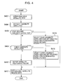
- Fig. 4 is a flowchart showing a satellite selection process performed by the satellite selecting processor 310.
- the satellite selection process is performed at constant intervals (e.g., at one-second intervals).
- the available-satellite data 302 is obtained from the GPS receiver 5 (step 402). Then, satellites that are recorded in the available-satellite record data 303 for all previous n (e.g., 10) times are extracted from the satellites available for satellite positioning included in the available-satellite data 302. Then, satellites whose variation between the receiving level indicated by the available-satellite data 302 and the most recent receiving level in the receiving levels indicated by the available-satellite record data 303 for the previous n times is smaller than a predetermined value are extracted from the extracted satellites as candidate satellites (step 404).
- n e.g. 10
- step 406 If the number of extracted candidate satellites is four or more (step 406), four satellites are selected from the four or more extracted candidate satellites so that a candidate satellite (or satellites) selected as the designated satellite (or satellites) the previous time is also selected this time as a designated satellite (or satellites) with priority.
- the satellite numbers of the four selected candidate satellites are set in the designated-satellite data 304, and the designated-satellite data 304 is then sent to the GPS receiver 5 (step 414). Then, the process proceeds to step 412.
- the satellite positioning unit 54 of the GPS receiver 5 performs three-dimensional positioning using the four satellites designated by the designated-satellite data 304.
- step 406 it is determined whether or not the number of extracted candidate satellites is three (step 408). If the number of extracted candidate satellites is three, the three extracted candidate satellites are selected as designated satellites, and the satellite numbers of the three designated satellites are set in the designated-satellite data 304, which is then sent to the GPS receiver 5 (step 416). Then, the process proceeds to step 412. In this case, as described above, the satellite positioning unit 54 of the GPS receiver 5 performs two-dimensional positioning using the three satellites designated by the designated-satellite data 304.
- step 408 If the number of extracted candidate satellites is smaller than three (step 408), a satellite positioning failure is reported to the map matching processor 13 (step 410). Then, the process proceeds to step 412.
- step 412 the available-satellite data 302 is accumulated in the available-satellite record data 303. Then, the process of this time ends.
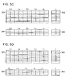
- n is 5 and all available satellites selected by the satellite filter 53 have a stable signal level.
- the satellite selection process in this case will be described with reference to Figs. 5A to 5D.
- the satellites having satellite numbers 1, 5, 9, and 11 selected as the designated satellites the previous time (T-1) are selected as the designated satellites this time (T) and are set in the designated-satellite data 304. Then, three-dimensional positioning using the four designated satellites is performed. As shown in Fig. 5A, once the satellites having satellite numbers 1, 5, 9, and 11 are selected as designated satellites, the satellites having satellite numbers 1, 5, 9, and 11 are continuously selected as designated satellites as long as the available-satellite data 302 includes satellite numbers 1, 5, 9, and 11.
- the satellite having satellite number 11 in the satellites having satellite numbers 1, 5, 9, and 11 continuously selected by the designated-satellite data 304 for the previous five times (T-1 to T-5) is not included in the available-satellite data 302 for this time (T)
- four of the satellites having satellite numbers 1, 2, 5, 8, and 9 included in the available-satellite data 302 for this time (T) and the available-satellite record data 303 for all previous five times (T-1 to T-5) are selected as designated satellites.
- the satellites having satellite numbers 1, 5, and 9 selected as the designated satellites the previous time (T-1) are selected with priority as designated satellites.
- the three satellites having satellite numbers 1, 5, and 9 are selected as the designated satellites this time (T).
- a satellite having one of satellite numbers 2 and 8 (in Fig. 5B, satellite number 8) is selected.
- the satellites having satellite numbers 1, 5, 8, and 9 are selected as the designated satellites this time (T).
- three-dimensional positioning is performed using these four designated satellites.
- the satellites having satellite numbers 1, 5, 8, and 9 are continuously selected as designated satellites as long as the available-satellite data 302 includes satellite numbers 1, 5, 8, and 9.
- satellite number 11 in the satellites having satellite numbers 1, 5, 9, and 11 continuously selected by the designated-satellite data 304 for the previous five times (T-1 to T-5), shown in Fig. 5A, is not included in the available-satellite data 302 for this time (T), and the three satellites having satellite numbers 1, 5, and 8 are still included in the available-satellite data 302 for this time (T) and the available-satellite record data 303 for the previous five times (T-1 to T-5).
- these three satellites are selected as the designated satellites this time (T), and two-dimensional positioning is performed using these three designated satellites.
- the three satellites having satellite numbers 1, 5, and 8 are continuously selected as designated satellites as long as the three satellites having satellite numbers 1, 5, and 8 are included in the available-satellite data 302 for a given time (T) and the available-satellite record data 303 for the previous five times (T-1 to T-5).
- Fig. 5D if the number of satellite numbers included in the available-satellite data 302 for this time (T) and the available-satellite record data 303 for the previous five times (T-1 to T-5) is changed to four or more, i.e., satellite numbers 1, 5, 8, and 13, four of these satellites are selected as the designated satellites this time (T), and three-dimensional positioning restarts using these four designated satellites.
- the satellites having satellite numbers 1, 5, 8, and 13 are continuously selected as designated satellites as long as the available-satellite data 302 includes satellite numbers 1, 5, 8, and 13.
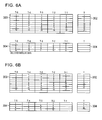
- Fig. 6B when the number of satellite numbers included in the available-satellite data 302 for this time (T) and the available-satellite record data 303 for all previous five times (T-1 to T-5) is turned to three or more (in Fig. 6B, satellite numbers 1, 5, and 13), designated satellites are selected in the way described above, and satellite positioning is performed again depending upon the number of designated satellites.
- the number of satellites stably available for satellite positioning for a predetermined period of time or longer up to now is four or more, four of the four or more satellites are selected for satellite positioning this time so that the combination of four satellites to be used for satellite positioning this time can be as similar as possible to the combination of four satellites used for satellite positioning the previous times. It is highly probable that the satellites stably available for satellite positioning for a predetermined period of time or longer up to now will also be stably available for satellite positioning in the future.
- the number of satellites stably available for satellite positioning for a predetermined period of time or longer is three, two-dimensional positioning is performed using these three satellites.
- stable two-dimensional positioning can be performed while suppressing frequent changes of the combination of designated satellites with high probability, which is normally caused by continuous three-dimensional positioning using four or more satellites.
- the current vehicle position is determined based on self-contained-navigation positioning without using satellite positioning.
- the current vehicle position can be stably determined while preventing a positioning error due to frequent changes of the combination of designated satellites used for satellite positioning with high probability, which is caused by continuous satellite positioning.
- the navigation apparatus may be implemented as a computer including a central processing unit (CPU), the memory 15, and an external storage device.
- the satellite selecting processor 310 may be implemented by the computer executing a program defining the processing described above.
Landscapes
- Engineering & Computer Science (AREA)
- Radar, Positioning & Navigation (AREA)
- Remote Sensing (AREA)
- Computer Networks & Wireless Communication (AREA)
- Physics & Mathematics (AREA)
- General Physics & Mathematics (AREA)
- Position Fixing By Use Of Radio Waves (AREA)
- Navigation (AREA)
- Traffic Control Systems (AREA)
Applications Claiming Priority (2)
| Application Number | Priority Date | Filing Date | Title |
|---|---|---|---|
| JP2004062032A JP4234039B2 (ja) | 2004-03-05 | 2004-03-05 | 衛星測位装置及びナビゲーション装置 |
| JP2004062032 | 2004-03-05 |
Publications (3)
| Publication Number | Publication Date |
|---|---|
| EP1571460A2 true EP1571460A2 (fr) | 2005-09-07 |
| EP1571460A3 EP1571460A3 (fr) | 2006-05-17 |
| EP1571460B1 EP1571460B1 (fr) | 2010-09-08 |
Family
ID=34747692
Family Applications (1)
| Application Number | Title | Priority Date | Filing Date |
|---|---|---|---|
| EP05250725A Ceased EP1571460B1 (fr) | 2004-03-05 | 2005-02-09 | Dispositif de détermination de position par satellite et méthode pour déterminer la position actuelle |
Country Status (5)
| Country | Link |
|---|---|
| US (1) | US7295155B2 (fr) |
| EP (1) | EP1571460B1 (fr) |
| JP (1) | JP4234039B2 (fr) |
| CN (1) | CN100498224C (fr) |
| DE (1) | DE602005023368D1 (fr) |
Cited By (5)
| Publication number | Priority date | Publication date | Assignee | Title |
|---|---|---|---|---|
| EP1804071A1 (fr) * | 2005-12-29 | 2007-07-04 | Alcatel Lucent | Procédé d'optimisation des traitements de données de localisation en présence de plusieurs constellations de positionnement par satellites |
| WO2007078223A1 (fr) | 2006-01-05 | 2007-07-12 | Nordnav Technologies Ab | Récepteur logiciel de spectre étalé |
| FR2927705A1 (fr) * | 2008-02-19 | 2009-08-21 | Thales Sa | Systeme de navigation a hybridation par les mesures de phase |
| CN113589345A (zh) * | 2021-08-03 | 2021-11-02 | 北京小米移动软件有限公司 | 定位方法、装置及存储介质 |
| CN118274828A (zh) * | 2024-06-03 | 2024-07-02 | 西安现代控制技术研究所 | 一种多特征融合的远程制导火箭弹末段组合导航切换方法 |
Families Citing this family (26)
| Publication number | Priority date | Publication date | Assignee | Title |
|---|---|---|---|---|
| JP3922585B2 (ja) * | 2004-05-13 | 2007-05-30 | セイコーエプソン株式会社 | 測位装置、測位方法、測位プログラム、測位プログラムを記録したコンピュータ読み取り可能な記録媒体 |
| JP4662158B2 (ja) * | 2006-01-20 | 2011-03-30 | アルパイン株式会社 | 自車位置判定装置 |
| US7570206B2 (en) * | 2006-03-23 | 2009-08-04 | Seiko Epson Corporation | Positioning device, positioning control method, positioning control program, and computer-readable recording medium having positioning control program recorded thereon |
| US7898474B2 (en) * | 2006-07-20 | 2011-03-01 | Seiko Epson Corporation | Positioning device, method of controlling positioning device, and recording medium having program for controlling positioning device recorded thereon |
| KR101478182B1 (ko) * | 2008-02-26 | 2015-01-02 | 삼성전자주식회사 | 보행자 이동방향 보정장치 및 그 방법 |
| JP5283439B2 (ja) * | 2008-07-04 | 2013-09-04 | 日本無線株式会社 | 衛星航法装置 |
| JP5586278B2 (ja) * | 2010-03-12 | 2014-09-10 | 三菱電機株式会社 | 測位データ評価装置、測位データ評価方法および測位データ評価プログラム |
| CN102401902A (zh) * | 2010-09-08 | 2012-04-04 | 神讯电脑(昆山)有限公司 | 卫星状态判断方法 |
| JP5365593B2 (ja) | 2010-09-13 | 2013-12-11 | 日本電気株式会社 | 信頼度の高いgps測位信号のみを用いた衛星航法補強システム |
| GB2491549A (en) * | 2011-01-05 | 2012-12-12 | Cambridge Silicon Radio Ltd | Satellite subset selection |
| GB2487348B (en) | 2011-01-05 | 2018-10-03 | Qualcomm Technologies Int Ltd | Calculation of location in a satellite navigation system with extended convergence zone |
| GB2487256B8 (en) | 2011-01-05 | 2015-04-01 | Cambridge Silicon Radio Ltd | Location fix from unknown position |
| GB201100114D0 (en) | 2011-01-05 | 2011-02-16 | Cambridge Silicon Radio Ltd | Determing positiion |
| US8634850B2 (en) | 2011-03-11 | 2014-01-21 | Qualcomm Incorporated | Providing wireless transmitter almanac information to mobile station based on expected contribution to future navigation operation |
| KR101437346B1 (ko) * | 2011-05-24 | 2014-09-04 | 이흥수 | Gps 수신기의 위치 계산 방법, 그 방법을 구현하기 위한 프로그램이 기록된 기록매체 및 gps 수신기 |
| CN102955162A (zh) * | 2011-08-16 | 2013-03-06 | 神基科技股份有限公司 | 卫星定位方法 |
| US20130197800A1 (en) * | 2012-01-31 | 2013-08-01 | Autotalks Ltd. | Method and system for gps augmentation using cooperative altitude learning |
| CN104297764A (zh) * | 2013-07-16 | 2015-01-21 | 凹凸电子(武汉)有限公司 | 一种提高导航系统时间的pps准确度的方法和接收机 |
| US9671499B2 (en) * | 2013-10-30 | 2017-06-06 | Microsoft Technology Licensing, Llc | High-sensitivity GPS device with directional antenna |
| CN103954982A (zh) * | 2014-04-18 | 2014-07-30 | 中国人民解放军国防科学技术大学 | 基于多模gnss接收机的可见卫星快速选择方法 |
| KR101846831B1 (ko) * | 2014-06-30 | 2018-04-09 | 후아웨이 테크놀러지 컴퍼니 리미티드 | 실내 위치결정 방법 및 장치 |
| WO2017046914A1 (fr) * | 2015-09-17 | 2017-03-23 | 三菱電機株式会社 | Dispositif de sélection de satellite de positionnement, dispositif de positionnement, système de positionnement, dispositif de transmission d'informations de positionnement et terminal de positionnement |
| CN106199654B (zh) * | 2016-08-23 | 2019-03-29 | 东南大学 | 卫星接收机快速冷启动方法 |
| CN108226985B (zh) * | 2017-12-25 | 2020-01-07 | 北京交通大学 | 基于精密单点定位的列车组合导航方法 |
| US11595815B2 (en) * | 2020-02-19 | 2023-02-28 | Higher Ground Llc | Using satellite diversity for enhancing communication confidentiality |
| JP7601066B2 (ja) * | 2022-08-10 | 2024-12-17 | カシオ計算機株式会社 | 情報処理装置、電子時計、情報処理方法及びプログラム |
Citations (1)
| Publication number | Priority date | Publication date | Assignee | Title |
|---|---|---|---|---|
| JPH05297104A (ja) | 1992-04-21 | 1993-11-12 | Mitsubishi Electric Corp | Gps受信装置 |
Family Cites Families (28)
| Publication number | Priority date | Publication date | Assignee | Title |
|---|---|---|---|---|
| US4114155A (en) * | 1976-07-30 | 1978-09-12 | Cincinnati Electronics Corporation | Position determining apparatus and method |
| JPS59214710A (ja) * | 1983-05-23 | 1984-12-04 | Hitachi Ltd | ナビゲ−シヨン装置 |
| JPS61137009A (ja) * | 1984-12-07 | 1986-06-24 | Nissan Motor Co Ltd | 車両用測位装置 |
| KR910004416B1 (ko) * | 1987-03-13 | 1991-06-27 | 미쓰비시덴기 가부시기가이샤 | 차량 탑재형 내비게이터 장치 |
| JPH0820504B2 (ja) * | 1987-09-22 | 1996-03-04 | 株式会社豊田中央研究所 | Gps航法装置 |
| JP2609292B2 (ja) * | 1988-06-22 | 1997-05-14 | 株式会社日立製作所 | Gps測位装置 |
| DE69126630T2 (de) * | 1990-03-06 | 1998-01-29 | Pioneer Electronic Corp | Navigationsgerät für Fahrzeuge |
| JP2584564B2 (ja) * | 1992-04-15 | 1997-02-26 | 住友電気工業株式会社 | 車両位置検出装置 |
| JPH06281721A (ja) | 1993-03-26 | 1994-10-07 | Matsushita Electric Works Ltd | ナビゲーション装置 |
| US5506588A (en) * | 1993-06-18 | 1996-04-09 | Adroit Systems, Inc. | Attitude determining system for use with global positioning system, and laser range finder |
| US6125325A (en) * | 1996-04-25 | 2000-09-26 | Sirf Technology, Inc. | GPS receiver with cross-track hold |
| DE19624719A1 (de) | 1996-06-21 | 1998-01-02 | Claas Ohg | System zur Positionsbestimmung von mobilen Objekten, insbesondere von Fahrzeugen |
| US5936571A (en) * | 1997-01-31 | 1999-08-10 | Lockheed Martin Corporation | Integrated GPS/interference location system |
| US6816710B2 (en) * | 1998-05-06 | 2004-11-09 | Snaptrack, Inc. | Method and apparatus for signal processing in a satellite positioning system |
| US6167347A (en) * | 1998-11-04 | 2000-12-26 | Lin; Ching-Fang | Vehicle positioning method and system thereof |
| JP2001021637A (ja) * | 1999-07-07 | 2001-01-26 | Mitsubishi Electric Corp | 位置測定装置および位置測定方法 |
| US6430504B1 (en) * | 2000-03-07 | 2002-08-06 | Trimble Navigation Ltd. | User interface for global positioning system receiver |
| US6778136B2 (en) * | 2001-12-13 | 2004-08-17 | Sirf Technology, Inc. | Fast acquisition of GPS signal |
| US6397147B1 (en) * | 2000-06-06 | 2002-05-28 | Csi Wireless Inc. | Relative GPS positioning using a single GPS receiver with internally generated differential correction terms |
| US6525688B2 (en) * | 2000-12-04 | 2003-02-25 | Enuvis, Inc. | Location-determination method and apparatus |
| JP4091276B2 (ja) * | 2001-07-09 | 2008-05-28 | 三菱電機株式会社 | 測位装置 |
| US6662107B2 (en) * | 2001-10-30 | 2003-12-09 | Sirf Technology, Inc. | Calibrated real time clock for acquisition of GPS signals during low power operation |
| JP2003139841A (ja) * | 2001-10-31 | 2003-05-14 | Hitachi Ltd | Gps内蔵携帯端末装置 |
| US6646596B2 (en) * | 2001-11-13 | 2003-11-11 | Nokia Corporation | Method, system and devices for positioning a receiver |
| KR100450954B1 (ko) * | 2002-06-12 | 2004-10-02 | 삼성전자주식회사 | 전세계위치확인 시스템에서 최적 위성의 선택방법 및 장치 |
| US6825805B2 (en) * | 2002-08-29 | 2004-11-30 | Qualcomm Incorporated | Search procedure for position determination system |
| US6882936B2 (en) * | 2003-03-03 | 2005-04-19 | Lockheed Martin Corporation | Integrated GPS/interference location system with anti-jam processor |
| JP2006138682A (ja) * | 2004-11-10 | 2006-06-01 | Alpine Electronics Inc | Gps受信器 |
-
2004
- 2004-03-05 JP JP2004062032A patent/JP4234039B2/ja not_active Expired - Fee Related
-
2005
- 2005-02-09 EP EP05250725A patent/EP1571460B1/fr not_active Ceased
- 2005-02-09 DE DE602005023368T patent/DE602005023368D1/de not_active Expired - Lifetime
- 2005-03-04 US US11/073,024 patent/US7295155B2/en not_active Expired - Lifetime
- 2005-03-07 CN CNB2005100526484A patent/CN100498224C/zh not_active Expired - Fee Related
Patent Citations (1)
| Publication number | Priority date | Publication date | Assignee | Title |
|---|---|---|---|---|
| JPH05297104A (ja) | 1992-04-21 | 1993-11-12 | Mitsubishi Electric Corp | Gps受信装置 |
Cited By (9)
| Publication number | Priority date | Publication date | Assignee | Title |
|---|---|---|---|---|
| EP1804071A1 (fr) * | 2005-12-29 | 2007-07-04 | Alcatel Lucent | Procédé d'optimisation des traitements de données de localisation en présence de plusieurs constellations de positionnement par satellites |
| US7646338B2 (en) | 2005-12-29 | 2010-01-12 | Alcatel Lucent | Method of optimization of processing of location data in the presence of a plurality of satellite positioning constellations |
| WO2007078223A1 (fr) | 2006-01-05 | 2007-07-12 | Nordnav Technologies Ab | Récepteur logiciel de spectre étalé |
| EP1969385A4 (fr) * | 2006-01-05 | 2013-10-30 | Nordnav Technologies Ab | Récepteur logiciel de spectre étalé |
| FR2927705A1 (fr) * | 2008-02-19 | 2009-08-21 | Thales Sa | Systeme de navigation a hybridation par les mesures de phase |
| US8311728B2 (en) | 2008-02-19 | 2012-11-13 | Thales | Navigation system using hybridization by phase measurements |
| CN113589345A (zh) * | 2021-08-03 | 2021-11-02 | 北京小米移动软件有限公司 | 定位方法、装置及存储介质 |
| CN113589345B (zh) * | 2021-08-03 | 2024-04-30 | 北京小米移动软件有限公司 | 定位方法、装置及存储介质 |
| CN118274828A (zh) * | 2024-06-03 | 2024-07-02 | 西安现代控制技术研究所 | 一种多特征融合的远程制导火箭弹末段组合导航切换方法 |
Also Published As
| Publication number | Publication date |
|---|---|
| CN100498224C (zh) | 2009-06-10 |
| JP4234039B2 (ja) | 2009-03-04 |
| EP1571460A3 (fr) | 2006-05-17 |
| JP2005249653A (ja) | 2005-09-15 |
| CN1664505A (zh) | 2005-09-07 |
| EP1571460B1 (fr) | 2010-09-08 |
| US20050195107A1 (en) | 2005-09-08 |
| DE602005023368D1 (de) | 2010-10-21 |
| US7295155B2 (en) | 2007-11-13 |
Similar Documents
| Publication | Publication Date | Title |
|---|---|---|
| EP1571460B1 (fr) | Dispositif de détermination de position par satellite et méthode pour déterminer la position actuelle | |
| US5272483A (en) | Navigation system | |
| US5293318A (en) | Navigation system | |
| US20110307171A1 (en) | GPS Location Refinement Method In Environments With Low Satellite Visibility | |
| US7136015B2 (en) | Method and apparatus for satellite positioning | |
| JPH08502827A (ja) | 車両ナビゲーションシステムのための位置修正方法 | |
| US8510077B1 (en) | Methods and apparatus for self-assisting positioning system | |
| JPH0518774A (ja) | 車両位置方位算出装置 | |
| JP2007127439A (ja) | ナビゲーション装置 | |
| EP1162432A1 (fr) | Dispositif de guidage de parcours | |
| JP2008139247A (ja) | Gps測位装置 | |
| JP6055185B2 (ja) | ナビゲーションデバイスの位置を決定すること | |
| KR100526571B1 (ko) | 오프-보드 네비게이션 시스템 및 그의 오차 보정 방법 | |
| JP2006242911A (ja) | 位置検出装置 | |
| KR20010092142A (ko) | 골프장에서의 홀컵의 위치 지시장치 및 그 방법 | |
| EP2146183B1 (fr) | Appareil de navigation et son procédé de positionnement | |
| JP2003207342A (ja) | 地図情報更新装置およびシステム | |
| JP7478701B2 (ja) | 地図処理装置、および、地図処理方法 | |
| US7428461B2 (en) | Walker navigation device, walker navigation method, and program | |
| JP4357357B2 (ja) | Gps衛星の測位装置、測位方法およびこれを利用したナビゲーション装置 | |
| JP2008249614A (ja) | 車載ナビゲーション装置、ナビゲーションシステム及びコンピュータプログラム | |
| JP2004301725A (ja) | ナビゲーション用gps受信方法及び受信機 | |
| JP4646720B2 (ja) | ナビゲーション装置 | |
| JP2007225459A (ja) | 車載器 | |
| JP2005016955A (ja) | 車載用ナビゲーション装置及び車載用ナビゲーション装置の測位方法 |
Legal Events
| Date | Code | Title | Description |
|---|---|---|---|
| PUAI | Public reference made under article 153(3) epc to a published international application that has entered the european phase |
Free format text: ORIGINAL CODE: 0009012 |
|
| AK | Designated contracting states |
Kind code of ref document: A2 Designated state(s): AT BE BG CH CY CZ DE DK EE ES FI FR GB GR HU IE IS IT LI LT LU MC NL PL PT RO SE SI SK TR |
|
| AX | Request for extension of the european patent |
Extension state: AL BA HR LV MK YU |
|
| PUAL | Search report despatched |
Free format text: ORIGINAL CODE: 0009013 |
|
| AK | Designated contracting states |
Kind code of ref document: A3 Designated state(s): AT BE BG CH CY CZ DE DK EE ES FI FR GB GR HU IE IS IT LI LT LU MC NL PL PT RO SE SI SK TR |
|
| AX | Request for extension of the european patent |
Extension state: AL BA HR LV MK YU |
|
| 17P | Request for examination filed |
Effective date: 20061009 |
|
| AKX | Designation fees paid |
Designated state(s): DE FR GB |
|
| 17Q | First examination report despatched |
Effective date: 20070308 |
|
| GRAP | Despatch of communication of intention to grant a patent |
Free format text: ORIGINAL CODE: EPIDOSNIGR1 |
|
| RIC1 | Information provided on ipc code assigned before grant |
Ipc: G01S 19/28 20100101AFI20100518BHEP |
|
| RIC1 | Information provided on ipc code assigned before grant |
Ipc: G01S 19/28 20100101AFI20100531BHEP |
|
| GRAS | Grant fee paid |
Free format text: ORIGINAL CODE: EPIDOSNIGR3 |
|
| GRAA | (expected) grant |
Free format text: ORIGINAL CODE: 0009210 |
|
| AK | Designated contracting states |
Kind code of ref document: B1 Designated state(s): DE FR GB |
|
| REG | Reference to a national code |
Ref country code: GB Ref legal event code: FG4D |
|
| REF | Corresponds to: |
Ref document number: 602005023368 Country of ref document: DE Date of ref document: 20101021 Kind code of ref document: P |
|
| PLBE | No opposition filed within time limit |
Free format text: ORIGINAL CODE: 0009261 |
|
| STAA | Information on the status of an ep patent application or granted ep patent |
Free format text: STATUS: NO OPPOSITION FILED WITHIN TIME LIMIT |
|
| 26N | No opposition filed |
Effective date: 20110609 |
|
| REG | Reference to a national code |
Ref country code: DE Ref legal event code: R097 Ref document number: 602005023368 Country of ref document: DE Effective date: 20110609 |
|
| REG | Reference to a national code |
Ref country code: FR Ref legal event code: PLFP Year of fee payment: 12 |
|
| REG | Reference to a national code |
Ref country code: FR Ref legal event code: PLFP Year of fee payment: 13 |
|
| REG | Reference to a national code |
Ref country code: DE Ref legal event code: R082 Ref document number: 602005023368 Country of ref document: DE Representative=s name: SCHMITT-NILSON SCHRAUD WAIBEL WOHLFROM PATENTA, DE |
|
| REG | Reference to a national code |
Ref country code: FR Ref legal event code: PLFP Year of fee payment: 14 |
|
| PGFP | Annual fee paid to national office [announced via postgrant information from national office to epo] |
Ref country code: GB Payment date: 20180216 Year of fee payment: 14 Ref country code: DE Payment date: 20180219 Year of fee payment: 14 |
|
| PGFP | Annual fee paid to national office [announced via postgrant information from national office to epo] |
Ref country code: FR Payment date: 20180223 Year of fee payment: 14 |
|
| REG | Reference to a national code |
Ref country code: DE Ref legal event code: R119 Ref document number: 602005023368 Country of ref document: DE |
|
| GBPC | Gb: european patent ceased through non-payment of renewal fee |
Effective date: 20190209 |
|
| PG25 | Lapsed in a contracting state [announced via postgrant information from national office to epo] |
Ref country code: GB Free format text: LAPSE BECAUSE OF NON-PAYMENT OF DUE FEES Effective date: 20190209 Ref country code: DE Free format text: LAPSE BECAUSE OF NON-PAYMENT OF DUE FEES Effective date: 20190903 |
|
| PG25 | Lapsed in a contracting state [announced via postgrant information from national office to epo] |
Ref country code: FR Free format text: LAPSE BECAUSE OF NON-PAYMENT OF DUE FEES Effective date: 20190228 |