EP1640936B1 - Verfahren und System für selektive Verarbeitung von Verkehrsunfallinformation - Google Patents
Verfahren und System für selektive Verarbeitung von Verkehrsunfallinformation Download PDFInfo
- Publication number
- EP1640936B1 EP1640936B1 EP05077065A EP05077065A EP1640936B1 EP 1640936 B1 EP1640936 B1 EP 1640936B1 EP 05077065 A EP05077065 A EP 05077065A EP 05077065 A EP05077065 A EP 05077065A EP 1640936 B1 EP1640936 B1 EP 1640936B1
- Authority
- EP
- European Patent Office
- Prior art keywords
- information
- incident
- traffic
- interest
- threshold
- Prior art date
- Legal status (The legal status is an assumption and is not a legal conclusion. Google has not performed a legal analysis and makes no representation as to the accuracy of the status listed.)
- Expired - Lifetime
Links
Images


Classifications
-
- G—PHYSICS
- G01—MEASURING; TESTING
- G01C—MEASURING DISTANCES, LEVELS OR BEARINGS; SURVEYING; NAVIGATION; GYROSCOPIC INSTRUMENTS; PHOTOGRAMMETRY OR VIDEOGRAMMETRY
- G01C21/00—Navigation; Navigational instruments not provided for in groups G01C1/00 - G01C19/00
- G01C21/26—Navigation; Navigational instruments not provided for in groups G01C1/00 - G01C19/00 specially adapted for navigation in a road network
- G01C21/34—Route searching; Route guidance
- G01C21/36—Input/output arrangements for on-board computers
- G01C21/3679—Retrieval, searching and output of POI information, e.g. hotels, restaurants, shops, filling stations, parking facilities
-
- G—PHYSICS
- G01—MEASURING; TESTING
- G01C—MEASURING DISTANCES, LEVELS OR BEARINGS; SURVEYING; NAVIGATION; GYROSCOPIC INSTRUMENTS; PHOTOGRAMMETRY OR VIDEOGRAMMETRY
- G01C21/00—Navigation; Navigational instruments not provided for in groups G01C1/00 - G01C19/00
- G01C21/26—Navigation; Navigational instruments not provided for in groups G01C1/00 - G01C19/00 specially adapted for navigation in a road network
- G01C21/34—Route searching; Route guidance
- G01C21/36—Input/output arrangements for on-board computers
- G01C21/3691—Retrieval, searching and output of information related to real-time traffic, weather, or environmental conditions
-
- G—PHYSICS
- G08—SIGNALLING
- G08G—TRAFFIC CONTROL SYSTEMS
- G08G1/00—Traffic control systems for road vehicles
- G08G1/09—Arrangements for giving variable traffic instructions
- G08G1/0962—Arrangements for giving variable traffic instructions having an indicator mounted inside the vehicle, e.g. giving voice messages
Definitions
- Radio broadcasts Users listen to radio broadcasts in a number of settings, including from within their vehicles.
- the content of these broadcasts may include a variety of news, traffic, information, and/or music.
- a user's reception of radio broadcasts was limited by the geographical area of where the user was located. For example, when a user passed between geographical regions, the radio signals often became attenuated to the point that the radio broadcast lost clarity or was lost altogether.
- Satellite radio broadcasts are transmitted using satellites that orbit the earth instead of the land based antennas associated with conventional broadcasting means. These transmissions are broadcast in a digital format, which enhances the quality of the broadcast received by radio users.
- the use of a satellite reduces and often eliminates the geographical limitations common to conventional radio broadcasts and allows for transmission of radio broadcasts across broad geographical regions, such as across the entire continental United States.
- satellite broadcasting typically includes a broad array of programs or listening selections.
- the broadcast of a signal across a broad geographical region complicates the reception and processing of locally relevant information such as traffic incidents or other geographically relevant information.
- RDS-TMC Radio Data System Traffic Management Channel
- US-B1-6266608 discloses a traffic information method which include receiving at least current location information, receiving at least a threshold range value, and relating said threshold range value to said current location information.
- the present system and method allows for the selective processing of incident reports, such as traffic accidents, contained within traffic incident information.
- One exemplary method includes receiving current location and heading information, receiving threshold range and bearing values, receiving an incident report corresponding to a traffic incident at a point of interest, and selectively retaining the incident report if the point of interest is within the threshold range and bearing values. This determination may be made by a traffic incident filter, which may be part of a traffic management system. This configuration allows for decreased memory and processor requirements, thereby reducing the cost of such a system.
- the exemplary traffic incident filter described herein may be used with satellite radio systems that include traffic management systems.
- the traffic incident filter allows the traffic management system to present only geographically relevant traffic incident information to the user through the satellite radio system. This configuration reduces the processor and/or memory requirements of the traffic management system, and thus the cost of implementing such a system.
- the traffic incident filter and the embodiments disclosed herein may be used to present any information pertinent to the user. Such pertinent information is not limited, and may include items such as the location of restaurants, rest stops or any other information pertinent to the user.
- an example relating to traffic incidents is used in connection with the embodiments described below. Such description is not intended to limit the embodiments to only traffic incidents.
- the traffic management system receives information related to traffic incidents across a broad geographical region.
- This traffic incident information includes the location of each traffic incident for all of the geographical region.
- the location of a particular traffic incident may be referred to as a point of interest.
- the system uses range and bearing threshold values in determining whether traffic incident information is relevant. For example, some traffic incidents are simply too distant to be of interest. In addition, some traffic incidents, while they may be within a distance that may be of interest, may nevertheless be irrelevant because they are not relevant to the direction or heading the user is taking. These values may be established in a number of ways, including presetting the values in the system or receiving the values from a user. These values are then used by the traffic incident filter to determine whether traffic incident information is geographically relevant.
- the traffic incident filter uses a filter algorithm to determine whether information related to a given traffic incident at its corresponding point of interest should be retained or discarded.
- the filter algorithm determines the relationship between the current location and heading and the point of interest.
- the algorithm determines whether the point of interest is within the threshold range and bearing values. If the point of interest is within the threshold range and bearing values, the filter algorithm provides an indication to the traffic management system that the information should be retained.
- the satellite radio system is then able to use the geographically relevant information in providing route planning, navigation, or other functions to a user.
- An exemplary satellite radio system will first be discussed. This discussion will include details of an exemplary traffic management system. Two exemplary applications of threshold values will then be discussed, explaining how zones of interest are defined by the threshold values and illustrating visually the operation of the traffic incident filter. An exemplary filter algorithm used by an exemplary traffic incident filter will then be described, showing the procedural operation of the traffic incident filter.
- Fig. 1 is a schematic view of a satellite radio system (100) that includes an exemplary traffic management system (110) and a satellite radio receiver (115).
- the satellite radio receiver (115) receives satellite radio broadcasts (170) according to well-known methods.
- the system (100) receives information related to traffic incidents.
- the traffic management system (110) retains only incident information relevant to the user.
- the traffic management system (110) includes a global positioning satellite (GPS) receiver (120), a traffic incident filter (130), a database (140), and a processor (150) with a controlling program (155) residing thereon.
- the traffic management system (110) receives GPS information (160) from GPS satellites (190) and traffic incident information (170) from SDARS (Satellite digital audio radio service) satellites (180). If the traffic incident filter (130) determines information pertaining to a given traffic incident is to be retained, the information is passed to the controlling program (155) and subsequently stored in retained memory (185).
- the processor (150) is then selectively able to access the retained memory (185) when prompted by a user.
- the traffic incident filter (130) allows the traffic management system (110) to present only meaningful information to the user by accepting only geographically meaningful information and rejecting undesired information.
- the incident filter (130) uses system location and heading information received from the GPS module (120) and threshold values to determine whether traffic incident information is relevant. The processing of the GPS information (160) will first be discussed, followed by a discussion of the traffic incident information (170) and how the incident filter uses this information.
- the GPS module (120) processes the GPS information (160) to determine the current position and heading of the user within the system (100).
- the exemplary GPS module (120) shown in Fig. 1 processes the GPS information (160) to determine current location in terms of latitude and longitude, wherein latitude is positive north of the equator and longitude is positive east.
- the GPS module (120) also determines the current heading in terms of azimuth, with the positive direction being clockwise relative to zero degrees north.
- the controlling program (155) also conveys threshold values to the traffic incident filter (130). These threshold values may include a threshold distance and a threshold bearing angle. The application of several exemplary threshold values will be discussed in more detail with reference to Figs. 2 and 3 .
- the traffic incident filter (130) uses the threshold location and bearing information values from the calling program to determine whether information related to a given traffic incident should be preserved in retained memory (185) or whether the information should be discarded.
- the traffic incident information (170) is received by the controlling program (155) and the corresponding location of each incident is processed by the traffic incident filter (130).
- the traffic incident information (170) may be information conveyed to the traffic incident filter (130) via a traffic message channel (TMC), which includes information about the location of incidents across a broad geographical region.
- TMC traffic message channel
- Information about each individual incident may be characterized by the location of the incident, or the point of interest and other information in the form of individual incident reports.
- the information transmitted over an exemplary TMC includes traffic incident information (170) for the entire USA in a pre-assigned frequency broadcast channel.
- This information is conveyed using a "virtual language" in which the codes broadcasted over the air corresponds to information stored in the database (140).
- the traffic incident filter (130) processes the location information of each incident report to determine whether the information related to that incident should be retained or discarded.
- the traffic incident filter (130) tells the controlling program (155) to discard the information. If the incident report is to be retained, the information is stored in retained memory (185).
- the information in the incident report corresponds to information stored on the database, such as lists of weather and traffic situations, advice, duration, and other information. This information also incorporates lists of locations, including intersections, road numbers, and place names.
- the processor (150) receives a command to process the incident report contained in the retained memory (185), it uses the "virtual language" contained therein to access the relevant information on the database and outputs the relevant information.
- the traffic incident filter (130) uses current location and range information and threshold values to determine whether each incident report contained in the traffic incident information is relevant and should be retained or whether the incident report is irrelevant and should be discarded. This configuration minimizes the processor and memory requirements of the traffic management system, while allowing for the benefits of satellite radio systems. Consequently, the traffic incident filter (130) provides for a more efficient and less expensive traffic management system and/or radio system that includes the same.
- the threshold values may be preset values, values determined by the controlling program based on current speed, past selections, or other criteria that are selected by the user.
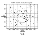
- FIG. 2 An application of an exemplary threshold value is shown in Fig. 2.
- Fig. 2 illustrates a geographical area of approximately 40 miles by 40 miles wherein a zone of interest (200) is shown.
- the mobile system is illustrated in Fig. 2 as moving in a heading of approximately 30 degrees. Further, the locations of several individual traffic incidents as represented by points of interest (210) are shown across the geographical area.
- the traffic incident filter 130 (See Fig. 1 ) receives the incident report for each of these incidents (210), as well as all the other incidents contained within a broader geographical area, such as across the USA.
- the traffic incident filter (130) uses threshold values to establish the zone of interest (200).
- the threshold values applied in Fig. 2 include a range threshold value of 10 miles and a bearing threshold of +/- 180 degrees. As a result, the zone of interest (200) defined by the threshold values forms a circle with a radius of 10 miles.
- the traffic incident filter (130) uses the location and bearing information and the threshold values passed thereto from the controlling program (155) to determine whether each incident report should be retained. If the traffic incident filter (130) determines that the incident report, which is represented by a point of interest (210), is within the range and bearing thresholds, the traffic incident filter (130) directs the controlling program (155) to retain the information.
- the incident reports that are retained are visually represented by points of interest (210) with full circles that fall within the zone of interest (200). Similarly, those incidents which are outside of either the range or bearing threshold are discarded. These incidents are visually represented by points of interest (210) with hollow circles that fall outside of the zone of interest (200).
- FIG. 3 Another exemplary zone of interest is shown in Fig. 3 .
- the threshold values shown by a zone of interest (200-1) represent a range threshold value of 10 miles and a bearing threshold of +/- 60 degrees. With such a configuration, if the azimuth or heading is taken with respect to the mobile system, the bearing arc that defines the zone of interest (200-1) will be between -30 degrees and 90 degrees. These values are obtained by subtracting and adding the bearing threshold value, or 60 degrees, from or to the current heading value, or 30 degrees.
- the size of the zone of interest (200-1) also depends on the range threshold value, or 10 miles.
- Fig. 3 illustrates that range and bearing threshold values may be selected to define a zone of interest of a desired size.
- the traffic incident filter 130 determines whether individual points of interest are within the range and bearing threshold and thus the corresponding incident reports should be retained. As previously discussed, this is represented graphically in the figures by the inclusion of points of interest (210) contained within the zone of interest (200-1). Any range threshold values and/or bearing threshold values may be selected to suit the needs of the mobile system.
- the traffic incident filter (130) uses a filter algorithm to determine whether each incident report should be retained for further processing or discarded. An exemplary filter algorithm used by the traffic incident filter (130) and the filter algorithm's interaction with the controlling program (155) will now be discussed in more detail.
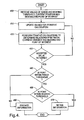
- Fig. 4 is a flowchart of an exemplary filter algorithm showing a method of determining whether an incident report should be retained or discarded. As will be discussed in more detail below, the filter algorithm reduces the processor and/or memory requirements of a traffic management system.
- the method begins by receiving values of the range and bearing threshold, the current position and bearing values, and the location of the point of interest (step 400).
- the range and bearing threshold values and the current position and bearing values may be conveyed to the traffic incident filter from the controlling program, while the traffic incident information, which includes the incident reports, may be received by the traffic management system and conveyed to the traffic incident filter.
- the information and values may be conveyed to the traffic incident filter by any suitable method, including the direct reception of all the values and information by the traffic incident filter.
- the traffic incident filter performs a set of calculations to relate the point of interest to the current position and bearing values.
- the exemplary determination discussed with reference to Fig. 4 includes a set of iterative calculations.
- an iterative solution which may be either direct or inverse, may be used to relate the point of interest to the current location and bearing values.
- Such an approach is more fully described in "Direct and Inverse Solutions of Geodesics on the Ellipsoid with Application on Nested Equations," VINCENTY, T. Survey Review Vol. XXIII No. 176 April, 1975; which is hereby incorporated by reference in its entirety. A summary of the iterative process will now be briefly discussed.
- the iterative process begins by updating the values for the iterative calculation (step 410). On the first iteration, the values used in the calculation are at an initial value. The iterative process then proceeds by performing iterative calculations to determine the relationship, including the distance and bearing, between the current location and the location of the point of interest (step 420). The iterative process narrows the difference between an iterative value and a calculated value until the difference is below a predetermined value. Once this difference is below the predetermined value, an accepted value is returned. If the filter determines that an accepted value has not been returned (NO, determination 430), the calculation values are updated (step 410) and the iterative calculation is again performed (step 420).
- the accepted value is checked against the range threshold (determination 440). If the point of interest is not within the range threshold (NO, determination 440), the information related to the traffic incident at the point of interest is discarded (step 460).
- the filter algorithm determines whether the point is also within the bearing threshold (determination 450). If the point of interest is not within the bearing threshold, the information is discarded (step 460). If the point of interest is within the bearing threshold (YES, determination 450), the algorithm issues a command to retain the information (step 470) for further processing.
- the traffic management system then stores the incident report in retained memory (185).
- the processor (150) is then able to selectively access the database in providing geographically relevant traffic incident reports.
- the traffic management system (110) may be configured to access the GPS module (120) to provide route planning to the user.
- the controlling program (155) may be configured to retrieve geographically relevant information, as determined by the threshold values, to suggest alternate routes.
- the traffic management system (110) may be configured to provide route planning information in addition to providing geographically relevant traffic incident information.
- This information may then be output to a navigation system having a visual display.
- this information may be output by other methods, such as by an audio system, alphanumeric display or other suitable methods.
- the exemplary traffic incident filter previously described may be used with satellite radio systems that include traffic management systems.
- the traffic incident filter allows the traffic management system to present only geographically relevant traffic incident information to the user through the satellite radio system. This configuration reduces the processor and/or memory requirements of the traffic management system, and thus the cost of implementing such a system.
- the traffic management system receives information related to traffic incidents across a broad geographical region.
- This traffic incident information includes the location of each traffic incident.
- the location of each traffic incident may be referred to as a point of interest.
- the system uses range and bearing threshold values in determining whether traffic incident information is relevant.
Landscapes
- Engineering & Computer Science (AREA)
- Radar, Positioning & Navigation (AREA)
- Remote Sensing (AREA)
- Physics & Mathematics (AREA)
- General Physics & Mathematics (AREA)
- Automation & Control Theory (AREA)
- Biodiversity & Conservation Biology (AREA)
- Atmospheric Sciences (AREA)
- Life Sciences & Earth Sciences (AREA)
- Ecology (AREA)
- Environmental & Geological Engineering (AREA)
- Environmental Sciences (AREA)
- Navigation (AREA)
- Position Fixing By Use Of Radio Waves (AREA)
- Traffic Control Systems (AREA)
- Alarm Systems (AREA)
- Mobile Radio Communication Systems (AREA)
Claims (12)
- Verfahren zum Betreiben eines Verkehrsverwaltungssystems (110), wobei das System aufweist ein Steuerungsprogramm (155), einen Verkehrshindernisfilter (130) in Kommunikation mit dem Steuerungsprogramm, und einen Verwahrungsspeicher (185), der zu dem Steuerungsprogramm gehört, wobei das Verfahren aufweist:Empfangen zumindest aktueller Positionsinformation (400) von einem GPS(global positioning system)-Satellit (190);Empfangen zumindest eines Schwellenbereichswerts (400);in Beziehung Bringen des Schwellenbereichswerts zu der aktuellen Positionsinformation (420), um eine Zone von Interesse zu bestimmen;Empfangen, von einem SDARS(Satellite Digital Audio Radio Service)-Satellit (180), eines Broadcasts, der eine Vielzahl von Hindernismeldungen aufweist, wobei jede Hindernismeldung einer relevanten Information an einem Punkt von Interesse (210) entspricht;Verarbeiten, durch den Verkehrshindernisfilter, jede dieser Hindernismeldungen durch Vergleich mit zumindest einem Lageschwellenwert und zumindest einem Bereichsschwellenwert zur Bestimmung, ob der Punkt von Interesse in der Zone von Interesse liegt;selektives Speichern, in dem Verwahrungsspeicher, einer Hindernismeldung (470) nur für die Punkte von Interesse (210) in der Zone von Interesse; undVerwerfen (460) der Hindernismeldungen, wenn der entsprechende Punkt von Interesse (210) außerhalb der Zone von Interesse (200) ist.
- Verfahren gemäß Anspruch 1, wobei die relevante Information (210) einem Verkehrshindernis (210) entspricht.
- Verfahren gemäß Anspruch 2, wobei das Verfahren weiter die Schritte umfasst eines Empfangens von aktueller Richtungsinformation (400) und in Beziehung bringen des Schwellenbereichswerts zu der Richtungsinformation (400).
- Verfahren gemäß Anspruch 3, wobei das Verfahren weiter die Schritte umfasst eines in Beziehung Bringens der Schwellenbereichs- und Schwellenlagewerte zu der Richtungsinformation (420).
- Verfahren gemäß Anspruch 4, wobei die Richtungsinformation (400) Information aufweist, die von einem globalen Positionsbestimmungssystem (190) empfangen wird.
- Verfahren gemäß Anspruch 4, wobei der Schritt des Empfangens der aktuellen Positionsinformation (400) und der Richtungsinformation (400) und der Schritt des Empfangens der Schwellenbereichs- und Schwellenlagewerte ein Empfangen der Information und der Werte von einem Steuerungsprogramm (155) aufweist.
- Verfahren gemäß Anspruch 2, wobei die Verkehrshindernisinformation Information von einem oder mehreren Verkehrshindernissen (210) über ein weites geographisches Gebiet enthält.
- Verfahren gemäß Anspruch 2, wobei die Verkehrshindernisinformation (170) einen Teil eines Verkehrsverwaltungskanals aufweist.
- Verfahren gemäß Anspruch 4, das weiter aufweist ein anfängliches Auswählen der Schwellenbereichs- und Lagewerte.
- Verfahren gemäß Anspruch 1, das weiter den Schritt aufweist eines Aufstellens des Schwellenbereichswerts (400) und Schwellenlagewerts (400) durch Empfangen einer Eingabe von einem Benutzer.
- Verfahren gemäß Anspruch 1, das weiter den Schritt aufweist eines Aufstellens des Schwellenbereichswerts (400) und Schwellenlagewerts (400) durch Aufstellen der Bereichs- und Lagewerte als voreingestellte Werte in einem Prozessor.
- Verkehrsverwaltungssystem (110), das aufweist:einen Verkehrshindernisfilter (130), der konfiguriert ist, Verkehrshindernisinformation (170) zu empfangen, einschließlich Hindernismeldungen über ein weites geographisches Gebiet;einen Prozessor oder ein Steuerungsprogramm (155) in Kommunikation mit dem Verkehrshindernisfilter (130), wobei der Verkehrshindernisfilter konfiguriert ist, zu bestimmen, ob die Hindernismeldungen geographisch relevante Hindernismeldungen sind; undeinen Verwahrungsspeicherteil (185), der konfiguriert ist, die geographisch relevanten Hindernismeldungen zu speichern;wobei das System das Verfahren gemäß Anspruch 1 durchführt.
Applications Claiming Priority (1)
| Application Number | Priority Date | Filing Date | Title |
|---|---|---|---|
| US10/946,837 US7526268B2 (en) | 2004-09-22 | 2004-09-22 | Method and system for selectively processing traffic incident information |
Publications (2)
| Publication Number | Publication Date |
|---|---|
| EP1640936A1 EP1640936A1 (de) | 2006-03-29 |
| EP1640936B1 true EP1640936B1 (de) | 2010-08-18 |
Family
ID=35448373
Family Applications (1)
| Application Number | Title | Priority Date | Filing Date |
|---|---|---|---|
| EP05077065A Expired - Lifetime EP1640936B1 (de) | 2004-09-22 | 2005-09-12 | Verfahren und System für selektive Verarbeitung von Verkehrsunfallinformation |
Country Status (4)
| Country | Link |
|---|---|
| US (1) | US7526268B2 (de) |
| EP (1) | EP1640936B1 (de) |
| AT (1) | ATE478411T1 (de) |
| DE (1) | DE602005022963D1 (de) |
Families Citing this family (23)
| Publication number | Priority date | Publication date | Assignee | Title |
|---|---|---|---|---|
| US8788192B2 (en) * | 2005-05-18 | 2014-07-22 | International Business Machines Corporation | Navigation method, system or service and computer program product |
| US7609203B2 (en) * | 2005-12-14 | 2009-10-27 | Delphi Technologies, Inc. | Method for ephemeris assisted global positioning |
| US9316738B2 (en) | 2005-12-28 | 2016-04-19 | The Directv Group, Inc. | Method and apparatus for controlling a mobile device beyond an area of interest boundary |
| US20070146200A1 (en) * | 2005-12-28 | 2007-06-28 | The Directv Group, Inc. | Method and apparatus for providing advertising and real time content to a mobile device based upon location |
| US20070149218A1 (en) * | 2005-12-28 | 2007-06-28 | The Directv Group, Inc. | Method and apparatus for conveying regions for controlling a mobile device based upon location |
| US7720431B2 (en) * | 2005-12-28 | 2010-05-18 | The Directv Group, Inc. | Method and apparatus for providing emergency information to a mobile receiving device |
| US8023883B1 (en) * | 2005-12-28 | 2011-09-20 | The Directv Group, Inc. | Method and apparatus for controlling handoffs in a mobile system |
| US7609172B2 (en) * | 2006-10-12 | 2009-10-27 | Garmin Ltd. | System and method for providing real-time traffic information |
| US7617045B2 (en) * | 2006-10-12 | 2009-11-10 | Visteon Global Technologies, Inc. | Programmable route specific dynamic traffic warning system |
| DE102007001857A1 (de) * | 2007-01-12 | 2008-07-17 | Siemens Ag | Verfahren und Vorrichtung zum Navigieren eines Fahrzeugs |
| US8180558B1 (en) * | 2007-04-04 | 2012-05-15 | Xm Satellite Radio Inc. | System and method for improved traffic flow reporting using satellite digital audio radio service (SDARS) and vehicle communications, navigation and tracking system |
| US8971926B2 (en) | 2007-07-05 | 2015-03-03 | The Directv Group, Inc. | Method and apparatus for warning a mobile user approaching a boundary of an area of interest |
| TWI379994B (en) * | 2008-03-28 | 2012-12-21 | Pegatron Corp | Navigation device and navigation information processing method thereof |
| US9466212B1 (en) * | 2010-01-05 | 2016-10-11 | Sirius Xm Radio Inc. | System and method for improved updating and annunciation of traffic enforcement camera information in a vehicle using a broadcast content delivery service |
| US20110238304A1 (en) * | 2010-03-25 | 2011-09-29 | Mark Steven Kendall | Method of Transmitting a Traffic Event Report for a Personal Navigation Device |
| EP2561315B1 (de) | 2010-04-21 | 2019-10-02 | TomTom Navigation B.V. | System und verfahren zur erstellung einer strecke durch eine elektronische karte |
| US8989699B2 (en) | 2010-07-27 | 2015-03-24 | Ford Global Technologies, Llc | Methods and apparatus for selective emergency alert notification and response |
| EP2687061A4 (de) * | 2011-03-17 | 2015-03-25 | Hewlett Packard Development Co | Selbstorganisation eines satellitennetzes |
| WO2013094865A1 (ko) * | 2011-12-18 | 2013-06-27 | 엘지전자 주식회사 | 경로 계산 방법, 경로 획득 방법 또는 이를 위한 단말 |
| EP2626846B1 (de) * | 2012-02-08 | 2014-05-14 | Skobbler GmbH | System und Verfahren zum Warnen eines Fahrzeugführers vor verkehrstechnischen Besonderheiten |
| WO2014170444A1 (en) | 2013-04-17 | 2014-10-23 | Tomtom International B.V. | Methods and apparatus for providing travel information |
| US20150169695A1 (en) * | 2013-12-12 | 2015-06-18 | TollShare, Inc. | Location based event identification |
| CN106133801A (zh) * | 2014-03-27 | 2016-11-16 | 三菱电机株式会社 | 驾驶辅助信息生成系统、驾驶辅助信息提供装置、驾驶辅助信息生成方法以及驾驶辅助信息生成程序 |
Family Cites Families (12)
| Publication number | Priority date | Publication date | Assignee | Title |
|---|---|---|---|---|
| DE4445582C2 (de) | 1994-12-20 | 2002-05-29 | Deutsche Automobilgesellsch | Verfahren und Einrichtung zur Ausgabe von Verkehrsstörungsmeldungen in einem Fahrzeug |
| DE19637127A1 (de) | 1996-09-12 | 1998-03-19 | Mannesmann Vdo Ag | Verfahren zur fahrtroutenspezifischen Selektion von Verkehrsinformationen und Empfangsgerät zum Ausführen des Verfahrens |
| US6208932B1 (en) * | 1996-09-30 | 2001-03-27 | Mazda Motor Corporation | Navigation apparatus |
| DE19847849A1 (de) * | 1998-10-16 | 2000-04-27 | Nokia Mobile Phones Ltd | Verfahren und Vorrichtung zur Selektion von Verkehrsinformation für ein Kraftfahrzeug |
| ES2261240T3 (es) * | 1999-10-11 | 2006-11-16 | Lastmile Communications Limited | Sistema de informacion. |
| US6731940B1 (en) * | 2000-04-28 | 2004-05-04 | Trafficmaster Usa, Inc. | Methods of using wireless geolocation to customize content and delivery of information to wireless communication devices |
| US6603033B2 (en) * | 2001-01-19 | 2003-08-05 | Korea Institute Of Science And Technology | Organotitanium precursors for chemical vapor deposition and manufacturing method thereof |
| US6741168B2 (en) * | 2001-12-13 | 2004-05-25 | Samsung Electronics Co., Ltd. | Method and apparatus for automated collection and transfer of collision information |
| US20050096842A1 (en) * | 2003-11-05 | 2005-05-05 | Eric Tashiro | Traffic routing method and apparatus for navigation system to predict travel time and departure time |
| US7412313B2 (en) * | 2004-01-07 | 2008-08-12 | Temic Automotive Of North America, Inc. | Maintenance assistance for a vehicle |
| US7532859B2 (en) * | 2004-08-30 | 2009-05-12 | General Motors Corporation | Targeted messaging for mobile vehicles using satellite-radio broadcasts |
| US7769340B2 (en) * | 2004-09-14 | 2010-08-03 | General Motors Llc | Method and system for program data dissemination |
-
2004
- 2004-09-22 US US10/946,837 patent/US7526268B2/en not_active Expired - Fee Related
-
2005
- 2005-09-12 DE DE602005022963T patent/DE602005022963D1/de not_active Expired - Lifetime
- 2005-09-12 AT AT05077065T patent/ATE478411T1/de not_active IP Right Cessation
- 2005-09-12 EP EP05077065A patent/EP1640936B1/de not_active Expired - Lifetime
Also Published As
| Publication number | Publication date |
|---|---|
| DE602005022963D1 (de) | 2010-09-30 |
| EP1640936A1 (de) | 2006-03-29 |
| US7526268B2 (en) | 2009-04-28 |
| US20060063559A1 (en) | 2006-03-23 |
| ATE478411T1 (de) | 2010-09-15 |
Similar Documents
| Publication | Publication Date | Title |
|---|---|---|
| US7526268B2 (en) | Method and system for selectively processing traffic incident information | |
| US6728522B1 (en) | Weather band radio and method of tuning same | |
| US5438687A (en) | System for selecting route-relevant information when using the radio data system (RDS) | |
| US7720431B2 (en) | Method and apparatus for providing emergency information to a mobile receiving device | |
| US7949330B2 (en) | System and method for providing weather warnings and alerts | |
| US6526268B1 (en) | Mobile weather band radio and method | |
| US5649300A (en) | Message delivery system and method therefor | |
| KR101467557B1 (ko) | 주행 경로 선택 | |
| CA2158500C (en) | Navigation system for an automotive vehicle | |
| EP2080179B1 (de) | System und Verfahren zur Bereitstellung von Echtzeit-Verkehrsinformationen. | |
| US20050033504A1 (en) | Satellite radio real time traffic updates | |
| US20080275640A1 (en) | Method of selecting route and terminal using the same | |
| EP1630978A2 (de) | Fahrzeug gerichtete geschaltete Antenna Anordnung | |
| GB2373655A (en) | Radio receiver in which station category related tuning information is selected in dependence on GPS or cellular system position information | |
| JP4627476B2 (ja) | サーバ及び車載ナビゲーション装置、車両、気象情報配信システム | |
| EP2346013A1 (de) | Verfahren zum Warnen eines Fahrers eines Straßenfahrzeugs vor einem Priorität genießendem Fahrzeug in der Nähe | |
| US20160112832A1 (en) | Data services via receivers independent of navigation systems | |
| JPH08330908A (ja) | 移動体fm受信機用選局処理装置 | |
| US7617045B2 (en) | Programmable route specific dynamic traffic warning system | |
| US20070149218A1 (en) | Method and apparatus for conveying regions for controlling a mobile device based upon location | |
| JP2003158690A (ja) | 車載用受信装置 | |
| EP1603258A2 (de) | Empfänger für digitalen Multimediarundfunk und Verfahren zur Anzeige der Kanäle | |
| US10205546B2 (en) | Method for operating a radio system, radio system and motor vehicle having a radio station | |
| JPH04372209A (ja) | 車載用放送受信装置 | |
| US7643787B2 (en) | Receiver system and method for receiving broadcasting |
Legal Events
| Date | Code | Title | Description |
|---|---|---|---|
| PUAI | Public reference made under article 153(3) epc to a published international application that has entered the european phase |
Free format text: ORIGINAL CODE: 0009012 |
|
| AK | Designated contracting states |
Kind code of ref document: A1 Designated state(s): AT BE BG CH CY CZ DE DK EE ES FI FR GB GR HU IE IS IT LI LT LU LV MC NL PL PT RO SE SI SK TR |
|
| AX | Request for extension of the european patent |
Extension state: AL BA HR MK YU |
|
| 17P | Request for examination filed |
Effective date: 20060929 |
|
| 17Q | First examination report despatched |
Effective date: 20061027 |
|
| AKX | Designation fees paid |
Designated state(s): AT BE BG CH CY CZ DE DK EE ES FI FR GB GR HU IE IS IT LI LT LU LV MC NL PL PT RO SE SI SK TR |
|
| GRAP | Despatch of communication of intention to grant a patent |
Free format text: ORIGINAL CODE: EPIDOSNIGR1 |
|
| GRAS | Grant fee paid |
Free format text: ORIGINAL CODE: EPIDOSNIGR3 |
|
| GRAA | (expected) grant |
Free format text: ORIGINAL CODE: 0009210 |
|
| AK | Designated contracting states |
Kind code of ref document: B1 Designated state(s): AT BE BG CH CY CZ DE DK EE ES FI FR GB GR HU IE IS IT LI LT LU LV MC NL PL PT RO SE SI SK TR |
|
| REG | Reference to a national code |
Ref country code: GB Ref legal event code: FG4D |
|
| REG | Reference to a national code |
Ref country code: CH Ref legal event code: EP |
|
| REG | Reference to a national code |
Ref country code: IE Ref legal event code: FG4D |
|
| REF | Corresponds to: |
Ref document number: 602005022963 Country of ref document: DE Date of ref document: 20100930 Kind code of ref document: P |
|
| REG | Reference to a national code |
Ref country code: NL Ref legal event code: VDEP Effective date: 20100818 |
|
| LTIE | Lt: invalidation of european patent or patent extension |
Effective date: 20100818 |
|
| PG25 | Lapsed in a contracting state [announced via postgrant information from national office to epo] |
Ref country code: LT Free format text: LAPSE BECAUSE OF FAILURE TO SUBMIT A TRANSLATION OF THE DESCRIPTION OR TO PAY THE FEE WITHIN THE PRESCRIBED TIME-LIMIT Effective date: 20100818 Ref country code: FI Free format text: LAPSE BECAUSE OF FAILURE TO SUBMIT A TRANSLATION OF THE DESCRIPTION OR TO PAY THE FEE WITHIN THE PRESCRIBED TIME-LIMIT Effective date: 20100818 Ref country code: AT Free format text: LAPSE BECAUSE OF FAILURE TO SUBMIT A TRANSLATION OF THE DESCRIPTION OR TO PAY THE FEE WITHIN THE PRESCRIBED TIME-LIMIT Effective date: 20100818 |
|
| PG25 | Lapsed in a contracting state [announced via postgrant information from national office to epo] |
Ref country code: BG Free format text: LAPSE BECAUSE OF FAILURE TO SUBMIT A TRANSLATION OF THE DESCRIPTION OR TO PAY THE FEE WITHIN THE PRESCRIBED TIME-LIMIT Effective date: 20101118 Ref country code: CY Free format text: LAPSE BECAUSE OF FAILURE TO SUBMIT A TRANSLATION OF THE DESCRIPTION OR TO PAY THE FEE WITHIN THE PRESCRIBED TIME-LIMIT Effective date: 20100818 Ref country code: IS Free format text: LAPSE BECAUSE OF FAILURE TO SUBMIT A TRANSLATION OF THE DESCRIPTION OR TO PAY THE FEE WITHIN THE PRESCRIBED TIME-LIMIT Effective date: 20101218 Ref country code: PL Free format text: LAPSE BECAUSE OF FAILURE TO SUBMIT A TRANSLATION OF THE DESCRIPTION OR TO PAY THE FEE WITHIN THE PRESCRIBED TIME-LIMIT Effective date: 20100818 Ref country code: PT Free format text: LAPSE BECAUSE OF FAILURE TO SUBMIT A TRANSLATION OF THE DESCRIPTION OR TO PAY THE FEE WITHIN THE PRESCRIBED TIME-LIMIT Effective date: 20101220 Ref country code: SI Free format text: LAPSE BECAUSE OF FAILURE TO SUBMIT A TRANSLATION OF THE DESCRIPTION OR TO PAY THE FEE WITHIN THE PRESCRIBED TIME-LIMIT Effective date: 20100818 |
|
| PG25 | Lapsed in a contracting state [announced via postgrant information from national office to epo] |
Ref country code: BE Free format text: LAPSE BECAUSE OF FAILURE TO SUBMIT A TRANSLATION OF THE DESCRIPTION OR TO PAY THE FEE WITHIN THE PRESCRIBED TIME-LIMIT Effective date: 20100818 Ref country code: LV Free format text: LAPSE BECAUSE OF FAILURE TO SUBMIT A TRANSLATION OF THE DESCRIPTION OR TO PAY THE FEE WITHIN THE PRESCRIBED TIME-LIMIT Effective date: 20100818 Ref country code: NL Free format text: LAPSE BECAUSE OF FAILURE TO SUBMIT A TRANSLATION OF THE DESCRIPTION OR TO PAY THE FEE WITHIN THE PRESCRIBED TIME-LIMIT Effective date: 20100818 Ref country code: GR Free format text: LAPSE BECAUSE OF FAILURE TO SUBMIT A TRANSLATION OF THE DESCRIPTION OR TO PAY THE FEE WITHIN THE PRESCRIBED TIME-LIMIT Effective date: 20101119 Ref country code: SE Free format text: LAPSE BECAUSE OF FAILURE TO SUBMIT A TRANSLATION OF THE DESCRIPTION OR TO PAY THE FEE WITHIN THE PRESCRIBED TIME-LIMIT Effective date: 20100818 |
|
| PG25 | Lapsed in a contracting state [announced via postgrant information from national office to epo] |
Ref country code: MC Free format text: LAPSE BECAUSE OF NON-PAYMENT OF DUE FEES Effective date: 20100930 Ref country code: DK Free format text: LAPSE BECAUSE OF FAILURE TO SUBMIT A TRANSLATION OF THE DESCRIPTION OR TO PAY THE FEE WITHIN THE PRESCRIBED TIME-LIMIT Effective date: 20100818 |
|
| REG | Reference to a national code |
Ref country code: CH Ref legal event code: PL |
|
| PG25 | Lapsed in a contracting state [announced via postgrant information from national office to epo] |
Ref country code: RO Free format text: LAPSE BECAUSE OF FAILURE TO SUBMIT A TRANSLATION OF THE DESCRIPTION OR TO PAY THE FEE WITHIN THE PRESCRIBED TIME-LIMIT Effective date: 20100818 Ref country code: EE Free format text: LAPSE BECAUSE OF FAILURE TO SUBMIT A TRANSLATION OF THE DESCRIPTION OR TO PAY THE FEE WITHIN THE PRESCRIBED TIME-LIMIT Effective date: 20100818 Ref country code: IT Free format text: LAPSE BECAUSE OF FAILURE TO SUBMIT A TRANSLATION OF THE DESCRIPTION OR TO PAY THE FEE WITHIN THE PRESCRIBED TIME-LIMIT Effective date: 20100818 Ref country code: CZ Free format text: LAPSE BECAUSE OF FAILURE TO SUBMIT A TRANSLATION OF THE DESCRIPTION OR TO PAY THE FEE WITHIN THE PRESCRIBED TIME-LIMIT Effective date: 20100818 Ref country code: SK Free format text: LAPSE BECAUSE OF FAILURE TO SUBMIT A TRANSLATION OF THE DESCRIPTION OR TO PAY THE FEE WITHIN THE PRESCRIBED TIME-LIMIT Effective date: 20100818 |
|
| PLBE | No opposition filed within time limit |
Free format text: ORIGINAL CODE: 0009261 |
|
| STAA | Information on the status of an ep patent application or granted ep patent |
Free format text: STATUS: NO OPPOSITION FILED WITHIN TIME LIMIT |
|
| PG25 | Lapsed in a contracting state [announced via postgrant information from national office to epo] |
Ref country code: ES Free format text: LAPSE BECAUSE OF FAILURE TO SUBMIT A TRANSLATION OF THE DESCRIPTION OR TO PAY THE FEE WITHIN THE PRESCRIBED TIME-LIMIT Effective date: 20101129 |
|
| 26N | No opposition filed |
Effective date: 20110519 |
|
| PG25 | Lapsed in a contracting state [announced via postgrant information from national office to epo] |
Ref country code: IE Free format text: LAPSE BECAUSE OF NON-PAYMENT OF DUE FEES Effective date: 20100912 Ref country code: LI Free format text: LAPSE BECAUSE OF NON-PAYMENT OF DUE FEES Effective date: 20100930 Ref country code: CH Free format text: LAPSE BECAUSE OF NON-PAYMENT OF DUE FEES Effective date: 20100930 |
|
| REG | Reference to a national code |
Ref country code: DE Ref legal event code: R097 Ref document number: 602005022963 Country of ref document: DE Effective date: 20110519 |
|
| PG25 | Lapsed in a contracting state [announced via postgrant information from national office to epo] |
Ref country code: HU Free format text: LAPSE BECAUSE OF FAILURE TO SUBMIT A TRANSLATION OF THE DESCRIPTION OR TO PAY THE FEE WITHIN THE PRESCRIBED TIME-LIMIT Effective date: 20110219 Ref country code: LU Free format text: LAPSE BECAUSE OF NON-PAYMENT OF DUE FEES Effective date: 20100912 |
|
| PG25 | Lapsed in a contracting state [announced via postgrant information from national office to epo] |
Ref country code: TR Free format text: LAPSE BECAUSE OF FAILURE TO SUBMIT A TRANSLATION OF THE DESCRIPTION OR TO PAY THE FEE WITHIN THE PRESCRIBED TIME-LIMIT Effective date: 20100818 |
|
| PGFP | Annual fee paid to national office [announced via postgrant information from national office to epo] |
Ref country code: GB Payment date: 20120925 Year of fee payment: 8 |
|
| PGFP | Annual fee paid to national office [announced via postgrant information from national office to epo] |
Ref country code: FR Payment date: 20121001 Year of fee payment: 8 |
|
| PGFP | Annual fee paid to national office [announced via postgrant information from national office to epo] |
Ref country code: DE Payment date: 20120927 Year of fee payment: 8 |
|
| REG | Reference to a national code |
Ref country code: DE Ref legal event code: R082 Ref document number: 602005022963 Country of ref document: DE Representative=s name: RIEDER & PARTNER PATENTANWAELTE - RECHTSANWALT, DE |
|
| REG | Reference to a national code |
Ref country code: DE Ref legal event code: R081 Ref document number: 602005022963 Country of ref document: DE Owner name: SMART AUDIO TECHNOLOGIES, LLC, US Free format text: FORMER OWNER: DELPHI TECHNOLOGIES, INC., TROY, US Effective date: 20130624 Ref country code: DE Ref legal event code: R082 Ref document number: 602005022963 Country of ref document: DE Representative=s name: RIEDER & PARTNER PATENTANWAELTE - RECHTSANWALT, DE Effective date: 20130624 Ref country code: DE Ref legal event code: R081 Ref document number: 602005022963 Country of ref document: DE Owner name: SMART AUDIO TECHNOLOGIES, LLC, TYLER, US Free format text: FORMER OWNER: DELPHI TECHNOLOGIES, INC., TROY, MICH., US Effective date: 20130624 Ref country code: DE Ref legal event code: R082 Ref document number: 602005022963 Country of ref document: DE Representative=s name: RIEDER & PARTNER MBB PATENTANWAELTE - RECHTSAN, DE Effective date: 20130624 |
|
| REG | Reference to a national code |
Ref country code: FR Ref legal event code: TP Owner name: SMART AUDIO TECHNOLOGIES LLC, US Effective date: 20130814 |
|
| GBPC | Gb: european patent ceased through non-payment of renewal fee |
Effective date: 20130912 |
|
| REG | Reference to a national code |
Ref country code: DE Ref legal event code: R119 Ref document number: 602005022963 Country of ref document: DE Effective date: 20140401 |
|
| REG | Reference to a national code |
Ref country code: FR Ref legal event code: ST Effective date: 20140530 |
|
| PG25 | Lapsed in a contracting state [announced via postgrant information from national office to epo] |
Ref country code: GB Free format text: LAPSE BECAUSE OF NON-PAYMENT OF DUE FEES Effective date: 20130912 |
|
| PG25 | Lapsed in a contracting state [announced via postgrant information from national office to epo] |
Ref country code: DE Free format text: LAPSE BECAUSE OF NON-PAYMENT OF DUE FEES Effective date: 20140401 Ref country code: FR Free format text: LAPSE BECAUSE OF NON-PAYMENT OF DUE FEES Effective date: 20130930 |