EP1710537A1 - Dispositif de navigation - Google Patents
Dispositif de navigation Download PDFInfo
- Publication number
- EP1710537A1 EP1710537A1 EP04799949A EP04799949A EP1710537A1 EP 1710537 A1 EP1710537 A1 EP 1710537A1 EP 04799949 A EP04799949 A EP 04799949A EP 04799949 A EP04799949 A EP 04799949A EP 1710537 A1 EP1710537 A1 EP 1710537A1
- Authority
- EP
- European Patent Office
- Prior art keywords
- location
- image
- data
- present location
- navigation device
- Prior art date
- Legal status (The legal status is an assumption and is not a legal conclusion. Google has not performed a legal analysis and makes no representation as to the accuracy of the status listed.)
- Withdrawn
Links
Images



Classifications
-
- G—PHYSICS
- G08—SIGNALLING
- G08G—TRAFFIC CONTROL SYSTEMS
- G08G1/00—Traffic control systems for road vehicles
- G08G1/09—Arrangements for giving variable traffic instructions
- G08G1/0962—Arrangements for giving variable traffic instructions having an indicator mounted inside the vehicle, e.g. giving voice messages
- G08G1/0968—Systems involving transmission of navigation instructions to the vehicle
- G08G1/096855—Systems involving transmission of navigation instructions to the vehicle where the output is provided in a suitable form to the driver
- G08G1/096872—Systems involving transmission of navigation instructions to the vehicle where the output is provided in a suitable form to the driver where instructions are given per voice
-
- G—PHYSICS
- G01—MEASURING; TESTING
- G01C—MEASURING DISTANCES, LEVELS OR BEARINGS; SURVEYING; NAVIGATION; GYROSCOPIC INSTRUMENTS; PHOTOGRAMMETRY OR VIDEOGRAMMETRY
- G01C21/00—Navigation; Navigational instruments not provided for in groups G01C1/00 - G01C19/00
- G01C21/26—Navigation; Navigational instruments not provided for in groups G01C1/00 - G01C19/00 specially adapted for navigation in a road network
- G01C21/34—Route searching; Route guidance
- G01C21/36—Input/output arrangements for on-board computers
- G01C21/3626—Details of the output of route guidance instructions
- G01C21/3647—Guidance involving output of stored or live camera images or video streams
-
- G—PHYSICS
- G08—SIGNALLING
- G08G—TRAFFIC CONTROL SYSTEMS
- G08G1/00—Traffic control systems for road vehicles
- G08G1/09—Arrangements for giving variable traffic instructions
- G08G1/0962—Arrangements for giving variable traffic instructions having an indicator mounted inside the vehicle, e.g. giving voice messages
- G08G1/0968—Systems involving transmission of navigation instructions to the vehicle
- G08G1/0969—Systems involving transmission of navigation instructions to the vehicle having a display in the form of a map
Definitions
- the present system relates to a navigation device that has functions capable of receiving and displaying image data.
- a known conventional navigation device for receiving surrounding images taken by a camera can automatically provide the situations of a portion hidden behind oncoming cars, based on the images taken by the camera installed in another vehicle.
- a vehicle attempts to turn to the right at an intersection where oncoming cars run, there is a strong possibility that the vehicle collides with a motorcycle hidden behind the oncoming cars invisible from the vehicle.
- a navigation device in which a plurality of users can communicate with each other via a center device, and when a vehicle requests an image taken from another vehicle and designates the position of the other vehicle, the center device searches the image and transmits the image to the requesting vehicle and the requesting vehicle can receive the transmitted image.
- the images can be exchanged only between the member vehicles.
- the present invention aims to provide a navigation device capable of receiving an image in any vehicle that is taken by another preceding vehicle in the route to the destination.
- a navigation device including: a present location positioning means for positioning a present location; a route setting means for inputting a destination and setting a route from the present location positioned by the present location positioning means to the destination; a location designating means for designating a predetermined location in the route from the present location to the destination set by the route setting means; an image receiving means for receiving image data having the location data designated by the location designating means, from preceding another vehicle; and a display means for displaying the image received by the image receiving means.
- the present location positioning means can position a present location
- the route setting means can set a route
- the location designating means designates a location. Therefore, the image receiving means can receive an image taken at a designated location in the route, from preceding another vehicle, and the display means can display the image. Thereby, a driver of the vehicle can recognize the precise visual scene of the designated location in the route along which the driver is going to drive.
- a navigation device in which the location designated by the location designating means includes: a distance location indicated by a distance from the present location; and a distance range ahead of the distance location.
- a navigation device in which both distance location and distance range can arbitrarily be set.
- This structure can arbitrarily set both distance location and distance range, and provide images in an arbitrary location and an arbitrary distance range
- an image receiving means receives an image having the largest electric field strength among those having location data matching the distance location and distance range from the present location.
- a navigation device in which preceding another vehicle is replaced with a center device, and the image data transmitted from the center device includes an image that is taken by an imaging means for taking the background of the present location of another navigation device and transmitted together with the data on the present location thereof.
- This structure can provide a vivid image at a further distance via the center device, i.e. preceding another vehicle.
- a navigation device further including: a character recognizing means for detecting and recognizing character data when the image data received by the image receiving means includes character data; and a voice output means for synthesizing and outputting character data recognized by the character data recognizing means, by voice.
- a navigation device further including: a character data recognizing means for detecting and recognizing character data when the image data received by the image receiving means includes the character data; a storage means having stored data including at least predetermined one of music, image, and information according to the specific character data; an data readout means for searching the storage means based on the character recognized by the character recognizing means and reading out data corresponding to the specific character data stored in the storage means that matches the character data recognized by the character data recognizing means; and a display means for displaying, by voice or image, the data read out by the data readout means.
- the navigation device when the received image includes character data, the navigation device recognizes the data, searches specific character data in the storage means based on the recognized character data, and outputs data, such as music, image, and information, corresponding to the specific data stored in the storage means. For example, the navigation device recognizes characters “Tokyo Tower” and specific character data "Tokyo Tower", information on the Tokyo Tower corresponding to the character data can be supplied.
- a navigation device further including: an imaging means for imaging the visual scene of the present location; and an image transmitting means for transmitting the image taken by the imaging means together with the present location data positioned by the present location positioning means.
- This structure can provide image data having present location data effective to another navigation device.
- the present invention includes: a present location positioning means for positioning a present location; a route setting means for inputting a destination and setting a route from the present location to the destination; a location designating means for designating a predetermined location from the present location in the route from the present location to the destination set by the route setting means; an image receiving means for receiving image data having the location data designated by the location designating means, from preceding another vehicle; and a display means for displaying the image received by the image receiving means.
- the present location positioning means can position a present location
- the route setting means can set a route
- the location designating means designates a location.
- the image receiving means can receive an image taken in a designated location in the route, from preceding another vehicle, and the display means can display the image.
- This structure can provide a navigation device that has an advantage of allowing a driver of the vehicle to recognize the visual scene of the designated location in the route along which the driver is going to drive.
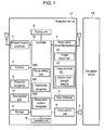
- Fig. 1 shows a navigation device in accordance with the exemplary embodiment of the present invention.
- Figs. 2 and 3 show first and second flowcharts representing the operation of the navigation device, respectively.
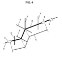
- Fig. 4 shows a schematic diagram illustrating the operation of the navigation device.
- navigation device 13 of the exemplary embodiment of the present invention includes: present location positioner 1 that has a global positioning system (GPS) receiver for positioning a present location, and self-contained navigation unit; and camera 2, i.e. an imaging means for imaging visual scenes ahead or around the present location; and map database 5 having stored map data.
- GPS global positioning system
- navigation device 13 of the exemplary embodiment includes: radio wave transmitter/receiver 4 for transmitting and receiving various kinds of data including image data; character recognizer 3 for recognizing characters, when the received image includes character data; voice output part 6 for outputting a various kinds of data as voice signals; and speaker 7 connected to voice output part 6.
- radio wave transmitter/receiver 4 has image transmitter 41 for transmitting images, and image receiver 42 for receiving images.
- navigation device 13 of the exemplary embodiment includes: display part 8 for displaying various kinds of data, such as a present location, map data, order, and command in a corresponding manner thereto; operation part 9 for inputting various kinds of orders, commands, and data items; and controller 10 for setting a route to a destination, designating a location of which image data is desired, and controlling each of these parts.
- display part 8 for displaying various kinds of data, such as a present location, map data, order, and command in a corresponding manner thereto
- operation part 9 for inputting various kinds of orders, commands, and data items
- controller 10 for setting a route to a destination, designating a location of which image data is desired, and controlling each of these parts.
- controller 10 includes: destination recognizer 101 having a function of recognizing the destination supplied from operation part 9; route setting part 102 having a function of setting a route to the destination according to a route searching order from operation part 9; and designated location recognizer 103 having a function of recognizing a location of which image data is desired and designated by operation part 9.
- navigation device 13 of the exemplary embodiment is described in detail.
- Present location positioner 1 including a GPS receiver and self-contained navigation unit, positions the present location.
- the positioned present location is displayed on display part 8, under control of controller 10, together with map data accumulated in map database 5.
- destination recognizer 101 of controller 10 recognizes the supplied destination. Then, a route from the present location to the destination is searched under control of route setting part 102 of controller 10, using map database 5. The searched route from the present location to the destination is shown on the map displayed on display part 8 with thicker lines or lines of different colors, for example, according to the setting.
- camera 2 is installed, facing to the front of the vehicle, for example, to image the place ahead of the vehicle. Therefore, camera 2 images the front of the vehicle.
- the image taken by camera 2 is transmitted to the outside of the vehicle together with data on the present location and running direction positioned by present location positioner 1 via image transmitter 41.
- image transmitter 41 it is possible to provide a storage for storing the images and data to be transmitted the outside.
- data on the present location and running direction of the vehicle is transmitted to the outside from navigation device 13 of the running vehicle together with the image data ahead thereof.
- the destination supplied is recognized by destination recognizer 101 of controller 10, and the route from the present location to the destination is searched under control of route setting part 102 of controller 10, using map database 5.
- the route from the present location to the destination is displayed on display part 8.
- the navigation device can receive, from preceding another vehicle, an image taken at the specific distance, and display the image taken thereby on display part 8.
- destination recognizer 101 of controller 10 recognizes the supplied destination, route setting part 102 searches the route from the present location to the destination using map database 5 (S303). Then, the result is shown on the map displayed on display part 8, using thicker lines, or lines of different colors (S304), for example.
- control returns to step S304, and the display part continues to display the route from the present location to the destination.
- the place at the specific distance from the present location is calculated under control of designated location recognizer 103 of controller 10 (S307) in the searched route.
- image receiver 42 of radio wave transmitter/receiver 4 receives an image of another vehicle that is running in the same direction in the searched route and has location data calculated by designated location recognizer 103, among the image data that is transmitted to the outside from navigation devices of running vehicles and has data on locations and running directions of the vehicles (S308), and the image is displayed on display part 8 (S309).
- route R searched is shown by a line thicker than other routes S.
- the navigator device When the user operates the navigator device to receive and display the image of the place at a specific distance, and inputs specific distance C, position D at specific distance C from present location A is calculated under control of designated location recognizer 103 of controller 10. Then, image receiver 42 of radio wave transmitter/receiver 4 receives an image having data on position D. At this time, the image receiver receives data not only on the location but also on the direction and an image of a scene in direction B toward the destination.
- entry of a specific distance allows reception of an image ahead of the place at the specific distance from the present location and display of the image together with data on the location and direction, on display part 8.
- the character data is cut out from the image and recognized as characters by character recognizer 3 (S311).
- the character data recognized by character recognizer 3 is supplied to voice output part 6 for output from speaker 7 by voice. Therefore, for example, the place name shown under a traffic light is read out by voice, so that the driver can accurately know the name of the place at the specific distance from the present location beforehand.
- the navigation device includes storage 11 having stored data on the place names and information, and data readout part 12 for reading data from storage 11.
- This structure allows the navigation device to read out the data corresponding to specific character data stored in storage 11 that matches the character data recognized by character recognizer 3, display the readout data on display 8 by image, and output the data through speaker 7 via voice output part 6.
- storage 11 has stored music data and image data in addition to such information data, not only voice information but also music and image corresponding to the recognized characters can be provided through speaker 7 or on display part 8.
- the navigation device receives image data including location data near the calculated location data in the same direction, from another vehicle, displays the data, and completes operation.
- the specific distance is preset to a certain distance, such as a certain value of meters and kilometers.
- this distance can have a specific distance range. In other words, it is possible not to simply specify a certain value of meters or kilometers ahead, but to specify a distance range from a certain value of meters to another value of meters, for example.
- This setting makes the navigation device more convenient because the device can receive images from any one of navigation devices existing in the distance range.
- the navigation device is more convenient because the device can receive an arbitrary image in an arbitrarily set range.
- the device can receive different images from a plurality of navigation devices at a time and cannot display the images on display part 8 properly in some cases.
- electric field strength detector 43 capable of receiving the image having the largest electric field is provided in image receiver 42, so that the navigation device can receive an image having the largest electric field strength only.
- the location is calculated according to the location data received at that time to provide the distance from the present location, under control of controller 10. The distance is given to the driver on display part 8 or through speaker 7, as a certain value of meters or kilometers ahead of the vehicle.
- This structure allows precise reception of an image of the place at a certain distance from the present location and proper display of the image on display part 8.
- the images to be taken by camera 2 can be moving images and sill images. Still images can be taken at regular periods or distances, and transmitted upon being taken.
- radio transmitter/receiver 4 need not be brought into the transmission state necessarily while the images are not taken. For this reason, radio transmitter/receiver 4 can be structured so as to transmit and receive data alternately. Of course, even in this case, radio transmitter/receiver 4 capable of transmission and reception at a time can be used in a similar manner to those always transmitting moving images.
- each navigation device 13 transmits an image taken by the camera thereof and directly receives an image from navigation device 14 at a specific distance ahead of the present location of navigation device 13.
- a center device i.e. preceding another vehicle, between both navigation devices.
- a center device When a center device is disposed among the navigation devices, communication between the center device and each navigation device can provide the image of a place at a further distance from the present location in real time.
- the center device can store the past data for a certain period of time.
- the present invention can easily provide an image of the place at a predetermined distance ahead of the present location.
- the present invention gives feeling of security to the driver thereof.
- a present location positioning means can position a present location
- a route setting means can set a route
- a location designating means designates a location.
- an image receiving means can receive an image taken by another device in a designated location in the route
- a display means can display the image.
- the navigation device has an advantage of providing the precise visual scene of the designated location in the route along which the driver is going to drive beforehand.
- the present invention is useful as a navigation device having functions of receiving and displaying image data.
Landscapes
- Engineering & Computer Science (AREA)
- Radar, Positioning & Navigation (AREA)
- Remote Sensing (AREA)
- Physics & Mathematics (AREA)
- General Physics & Mathematics (AREA)
- Automation & Control Theory (AREA)
- Multimedia (AREA)
- Navigation (AREA)
- Instructional Devices (AREA)
- Character Discrimination (AREA)
- Mobile Radio Communication Systems (AREA)
Applications Claiming Priority (2)
| Application Number | Priority Date | Filing Date | Title |
|---|---|---|---|
| JP2003407250 | 2003-12-05 | ||
| PCT/JP2004/018099 WO2005054783A1 (fr) | 2003-12-05 | 2004-11-30 | Dispositif de navigation |
Publications (1)
| Publication Number | Publication Date |
|---|---|
| EP1710537A1 true EP1710537A1 (fr) | 2006-10-11 |
Family
ID=34650303
Family Applications (1)
| Application Number | Title | Priority Date | Filing Date |
|---|---|---|---|
| EP04799949A Withdrawn EP1710537A1 (fr) | 2003-12-05 | 2004-11-30 | Dispositif de navigation |
Country Status (5)
| Country | Link |
|---|---|
| US (1) | US20070143009A1 (fr) |
| EP (1) | EP1710537A1 (fr) |
| JP (1) | JPWO2005054783A1 (fr) |
| CN (1) | CN1890533A (fr) |
| WO (1) | WO2005054783A1 (fr) |
Families Citing this family (14)
| Publication number | Priority date | Publication date | Assignee | Title |
|---|---|---|---|---|
| US7474959B2 (en) * | 2004-10-08 | 2009-01-06 | Scenera Technologies, Llc | Method for providing recommendations using image, location data, and annotations |
| DE102004049870A1 (de) * | 2004-10-13 | 2006-04-20 | Robert Bosch Gmbh | Verfahren und Vorrichtung zur Verbesserung der Sicht von Fahrern von Kraftfahrzeugen |
| JP2007089017A (ja) * | 2005-09-26 | 2007-04-05 | Pioneer Electronic Corp | 通信端末、データ送信方法、データ受信方法、データ送信プログラム、データ受信プログラムおよび記録媒体 |
| JP4935145B2 (ja) * | 2006-03-29 | 2012-05-23 | 株式会社デンソー | カーナビゲーション装置 |
| US7945576B2 (en) * | 2007-05-29 | 2011-05-17 | Microsoft Corporation | Location recognition using informative feature vocabulary trees |
| CN102012230A (zh) * | 2010-08-27 | 2011-04-13 | 杭州妙影微电子有限公司 | 一种道路实景导航方法 |
| ITTO20110686A1 (it) * | 2011-07-28 | 2013-01-29 | Sisvel Technology Srl | Metodo per garantire la continuità di servizio di un dispositivo di navigazione personale e relativo dispositivo |
| CN104422439B (zh) * | 2013-08-21 | 2017-12-19 | 希姆通信息技术(上海)有限公司 | 导航方法、装置、服务器、导航系统及其使用方法 |
| JP2016138816A (ja) * | 2015-01-28 | 2016-08-04 | アルパイン株式会社 | ナビゲーション装置及びコンピュータプログラム |
| JP6540485B2 (ja) * | 2015-12-07 | 2019-07-10 | 株式会社デンソー | 経路変更装置及び経路変更システム |
| DE102016203725A1 (de) * | 2016-03-08 | 2017-09-14 | Robert Bosch Gmbh | Informationssystem für ein Kraftfahrzeug |
| CN106845470B (zh) * | 2017-02-20 | 2020-12-11 | 百度在线网络技术(北京)有限公司 | 地图数据采集方法和装置 |
| CN107677289B (zh) * | 2017-09-30 | 2020-04-28 | 百度在线网络技术(北京)有限公司 | 信息处理方法、装置以及机动车 |
| JP7236677B2 (ja) * | 2019-12-25 | 2023-03-10 | パナソニックIpマネジメント株式会社 | 通信装置および通信方法 |
Family Cites Families (5)
| Publication number | Priority date | Publication date | Assignee | Title |
|---|---|---|---|---|
| JPH05174294A (ja) * | 1991-12-24 | 1993-07-13 | Sharp Corp | 道路標識読取装置 |
| JPH11298813A (ja) * | 1998-04-15 | 1999-10-29 | Sony Corp | テレビ受像機 |
| JP3969852B2 (ja) * | 1998-06-29 | 2007-09-05 | キヤノン株式会社 | 移動体間通信システム、通信装置 |
| JP4505958B2 (ja) * | 2000-07-12 | 2010-07-21 | 株式会社エクォス・リサーチ | 情報送信方法及びシステム |
| JP2003067407A (ja) * | 2001-08-24 | 2003-03-07 | Clarion Co Ltd | 車載情報検索機器及び情報検索方法 |
-
2004
- 2004-11-30 JP JP2005516009A patent/JPWO2005054783A1/ja not_active Withdrawn
- 2004-11-30 WO PCT/JP2004/018099 patent/WO2005054783A1/fr not_active Ceased
- 2004-11-30 US US10/581,896 patent/US20070143009A1/en not_active Abandoned
- 2004-11-30 CN CNA2004800358444A patent/CN1890533A/zh active Pending
- 2004-11-30 EP EP04799949A patent/EP1710537A1/fr not_active Withdrawn
Non-Patent Citations (1)
| Title |
|---|
| See references of WO2005054783A1 * |
Also Published As
| Publication number | Publication date |
|---|---|
| CN1890533A (zh) | 2007-01-03 |
| WO2005054783A1 (fr) | 2005-06-16 |
| JPWO2005054783A1 (ja) | 2007-06-28 |
| US20070143009A1 (en) | 2007-06-21 |
Similar Documents
| Publication | Publication Date | Title |
|---|---|---|
| EP1439373B1 (fr) | Dispositif et procédé pour fournir de l'information de trafic dans un système de navigation | |
| US7630830B2 (en) | Navigation apparatus, driving direction guidance method, and navigation system | |
| US7386437B2 (en) | System for providing translated information to a driver of a vehicle | |
| US6963799B2 (en) | Road traffic information processing apparatus, road traffic information processing method, computer program, and information record medium | |
| US7650235B2 (en) | Telematics system using image data and method for directing a route by using the same | |
| EP1484580B1 (fr) | Appareil et procédé pour fournir des itinéraires dans un système de navigation | |
| US5787382A (en) | Navigation apparatus for displaying a map by limit information | |
| EP1710537A1 (fr) | Dispositif de navigation | |
| US20050209776A1 (en) | Navigation apparatus and intersection guidance method | |
| CN101578501A (zh) | 导航装置及方法 | |
| US8548737B2 (en) | Navigation apparatus | |
| EP2829844A1 (fr) | Système de navigation | |
| JP4489619B2 (ja) | ナビゲーション装置および自車相対位置の案内方法 | |
| KR20070031641A (ko) | 무선주파수식별 시스템을 이용한 네비게이션 시스템 및공사구간 도로 표시/해제 방법 | |
| JP2002156239A (ja) | 車載用カーナビゲーション装置 | |
| KR19990030808A (ko) | 인터넷을 이용한 교통정보 제공 방법 및 장치 | |
| JP3259553B2 (ja) | 探索経路受信装置及び探索経路送信装置 | |
| US6078863A (en) | Method of preparing route guide information for the driver of a vehicle | |
| KR20090051340A (ko) | 경로 탐색 방법 및 이를 이용한 네비게이션 장치 | |
| JP2005128603A (ja) | 物体認知装置および物体認知方法 | |
| JPH06174481A (ja) | バーコード表示体、並びにそれを利用した情報出力装置、ナビゲーション装置及び地図情報検索システム | |
| JP2000055677A (ja) | 車両間通信方式 | |
| EP4184118A1 (fr) | Procédé de détermination et de communication d'un itinéraire de deplacement d'un utilisateur d'un véhicule routier | |
| US20030046001A1 (en) | Route guidance system, method, and program for automotive vehicle | |
| JP2003232642A (ja) | 指定距離通知装置およびナビゲーション装置 |
Legal Events
| Date | Code | Title | Description |
|---|---|---|---|
| PUAI | Public reference made under article 153(3) epc to a published international application that has entered the european phase |
Free format text: ORIGINAL CODE: 0009012 |
|
| 17P | Request for examination filed |
Effective date: 20060531 |
|
| AK | Designated contracting states |
Kind code of ref document: A1 Designated state(s): DE FR GB |
|
| DAX | Request for extension of the european patent (deleted) | ||
| RBV | Designated contracting states (corrected) |
Designated state(s): DE FR GB |
|
| STAA | Information on the status of an ep patent application or granted ep patent |
Free format text: STATUS: THE APPLICATION HAS BEEN WITHDRAWN |
|
| 18W | Application withdrawn |
Effective date: 20080714 |