EP1710768A2 - Navigationssystem und -verfahren - Google Patents
Navigationssystem und -verfahren Download PDFInfo
- Publication number
- EP1710768A2 EP1710768A2 EP06251698A EP06251698A EP1710768A2 EP 1710768 A2 EP1710768 A2 EP 1710768A2 EP 06251698 A EP06251698 A EP 06251698A EP 06251698 A EP06251698 A EP 06251698A EP 1710768 A2 EP1710768 A2 EP 1710768A2
- Authority
- EP
- European Patent Office
- Prior art keywords
- detour
- route
- optimum
- destination
- traffic
- Prior art date
- Legal status (The legal status is an assumption and is not a legal conclusion. Google has not performed a legal analysis and makes no representation as to the accuracy of the status listed.)
- Granted
Links
- 238000000034 method Methods 0.000 title claims abstract description 44
- 230000008569 process Effects 0.000 description 13
- 238000004364 calculation method Methods 0.000 description 4
- 238000010586 diagram Methods 0.000 description 4
- 238000001514 detection method Methods 0.000 description 3
- 230000004048 modification Effects 0.000 description 3
- 238000012986 modification Methods 0.000 description 3
- 238000010187 selection method Methods 0.000 description 3
- 230000008901 benefit Effects 0.000 description 2
- 230000008859 change Effects 0.000 description 2
- 230000008030 elimination Effects 0.000 description 2
- 238000003379 elimination reaction Methods 0.000 description 2
- 230000009286 beneficial effect Effects 0.000 description 1
- 230000003287 optical effect Effects 0.000 description 1
Images



Classifications
-
- G—PHYSICS
- G08—SIGNALLING
- G08G—TRAFFIC CONTROL SYSTEMS
- G08G1/00—Traffic control systems for road vehicles
- G08G1/09—Arrangements for giving variable traffic instructions
- G08G1/0962—Arrangements for giving variable traffic instructions having an indicator mounted inside the vehicle, e.g. giving voice messages
- G08G1/0968—Systems involving transmission of navigation instructions to the vehicle
- G08G1/096805—Systems involving transmission of navigation instructions to the vehicle where the transmitted instructions are used to compute a route
- G08G1/096827—Systems involving transmission of navigation instructions to the vehicle where the transmitted instructions are used to compute a route where the route is computed onboard
-
- G—PHYSICS
- G01—MEASURING; TESTING
- G01C—MEASURING DISTANCES, LEVELS OR BEARINGS; SURVEYING; NAVIGATION; GYROSCOPIC INSTRUMENTS; PHOTOGRAMMETRY OR VIDEOGRAMMETRY
- G01C21/00—Navigation; Navigational instruments not provided for in groups G01C1/00 - G01C19/00
- G01C21/26—Navigation; Navigational instruments not provided for in groups G01C1/00 - G01C19/00 specially adapted for navigation in a road network
- G01C21/34—Route searching; Route guidance
- G01C21/3407—Route searching; Route guidance specially adapted for specific applications
- G01C21/3415—Dynamic re-routing, e.g. recalculating the route when the user deviates from calculated route or after detecting real-time traffic data or accidents
-
- G—PHYSICS
- G08—SIGNALLING
- G08G—TRAFFIC CONTROL SYSTEMS
- G08G1/00—Traffic control systems for road vehicles
- G08G1/09—Arrangements for giving variable traffic instructions
- G08G1/0962—Arrangements for giving variable traffic instructions having an indicator mounted inside the vehicle, e.g. giving voice messages
- G08G1/0968—Systems involving transmission of navigation instructions to the vehicle
- G08G1/096805—Systems involving transmission of navigation instructions to the vehicle where the transmitted instructions are used to compute a route
- G08G1/096811—Systems involving transmission of navigation instructions to the vehicle where the transmitted instructions are used to compute a route where the route is computed offboard
-
- G—PHYSICS
- G08—SIGNALLING
- G08G—TRAFFIC CONTROL SYSTEMS
- G08G1/00—Traffic control systems for road vehicles
- G08G1/09—Arrangements for giving variable traffic instructions
- G08G1/0962—Arrangements for giving variable traffic instructions having an indicator mounted inside the vehicle, e.g. giving voice messages
- G08G1/0968—Systems involving transmission of navigation instructions to the vehicle
- G08G1/096833—Systems involving transmission of navigation instructions to the vehicle where different aspects are considered when computing the route
- G08G1/096844—Systems involving transmission of navigation instructions to the vehicle where different aspects are considered when computing the route where the complete route is dynamically recomputed based on new data
-
- G—PHYSICS
- G08—SIGNALLING
- G08G—TRAFFIC CONTROL SYSTEMS
- G08G1/00—Traffic control systems for road vehicles
- G08G1/09—Arrangements for giving variable traffic instructions
- G08G1/0962—Arrangements for giving variable traffic instructions having an indicator mounted inside the vehicle, e.g. giving voice messages
- G08G1/0968—Systems involving transmission of navigation instructions to the vehicle
- G08G1/096855—Systems involving transmission of navigation instructions to the vehicle where the output is provided in a suitable form to the driver
- G08G1/096872—Systems involving transmission of navigation instructions to the vehicle where the output is provided in a suitable form to the driver where instructions are given per voice
Definitions
- the present invention relates to a navigation system and method and particularly, but not exclusively, to a navigation system and method for navigating a vehicle along a route to a destination. Aspects of the invention also relate to an apparatus.
- Japanese Kokai Patent Application No. 2001-349735 teaches a navigation device wherein when a traffic restriction or traffic jam or the like arises on the route to a destination, the device guides a vehicle to a detour route at a predetermined distance or time from the site where the traffic restriction or traffic jam has arisen.
- aspects of the invention therefore provide a navigation system an a method of navigating a vehicle as set out in the appending claims.
- an apparatus for navigating a vehicle comprising an input device operable to set a destination, a location detector operable to detect a current location of the vehicle, at least one receiver operable to acquire traffic information, including an existence of a traffic obstacle on an optimum route from the current location to the destination and a controller operable to search for a detour having at least one of the shortest time to the destination and the shortest distance to the destination in order to detour around the traffic obstacle when the existence of the traffic obstacle is detected; and the controller operable to perform guidance related to the detour a prescribed distance before a branching point that branches from the optimum route to the detour.
- controller is operable to search for the optimum route from the current location to the destination.
- the detour having the shortest time to the destination is an optimum detour route.
- the controller may be operable to search among a plurality of detours for detouring around the traffic obstacle for a last detour route to the destination branching from a branching site on the optimum route nearest the traffic obstacle.
- the controller may be operable to select one of the optimum detour route and the last detour route based on a branching site distance between the branching point for the optimum detour route on the optimum route and the branching point for the last detour route and a required time difference between a required running time from the current location via the optimum detour route to the destination and a required running time from the current location via the last detour route to the destination.
- the controller is operable to create a linear relationship between the branching site distance and the required time difference whereby the slope is designated as k.
- the controller may be operable to select the optimum detour route when the time difference is greater than one of the branching point distance multiplied by k and a preset time difference threshold.
- an apparatus for navigating a vehicle comprising destination setting means for setting a destination, current location detection means for detecting a current location of the vehicle, traffic information acquisition means for acquiring traffic information, route search means for searching for an optimum route from the current location to the destination, detour search means for searching for a detour having at least one of a shortest time and a shortest distance to the destination to detour around a traffic obstacle when the traffic obstacle is detected on the optimum route and detour guidance means for performing guidance at a prescribed distance before a branching point that branches from the optimum route to the detour.
- the prescribed distance is based on a preparation time for branching to the detour and the vehicle speed.
- the detour guidance means comprises re-searching means for searching the optimum route to the destination at the prescribed distance; and wherein the detour guidance means further comprises means for directing the vehicle along the detour at the branching point when the traffic obstacle still exists.
- the detour with the shortest time to the destination is an optimum detour route.
- the detour search means may comprise means for searching for a last detour route that branches nearest the traffic obstacle from among a plurality of detour routes for detouring the traffic obstacle on the optimum route.
- the apparatus may comprise means for selecting one of the optimum detour route and the last detour route based on a branching point distance between a first branching point for the optimum detour route on the optimum route and a second branching point for the last detour route and the time difference between a running time from the current location to the destination via the optimum detour route and a running time from the current location to the destination via the last detour route.
- the apparatus may comprise a plane with the branching point distance and the time difference reflected in two dimensions and a detour route selecting map wherein the last detour route has a largest branching point distance and the optimum detour route has a largest time difference.
- the route search means may be operable to select one of the optimum detour route and the last detour route according to the detour route selecting map.
- the route search means is operable to select the optimum detour route when the time difference is longer than a preset threshold, even when the branching point distance is large.
- a method for navigating a vehicle comprising setting a destination, detecting a current location of the vehicle, acquiring traffic information, searching for an optimum route from the current location to the destination, searching for a detour having at least one of a shortest time and a shortest distance to the destination to detour around a traffic obstacle when the traffic obstacle is detected based on the acquired traffic information and performing guidance at a prescribed distance before a branching point that branches from the optimum route to the detour.
- the method may include determining the prescribed distance based on a preparation time for branching to the detour and the vehicle speed at the branching point.
- the method may comprise searching for a last detour route, wherein the last detour route branches from the optimum route at a point nearest the existence of the traffic obstacle and selecting one of the detour route and the last detour route for the vehicle to follow when performing guidance at the prescribed distance.
- the method may comprise designating the detour having the shortest time as the optimum detour route searching for a last detour route, wherein the last detour route branches from the optimum route at a point nearest the existence of the traffic obstacle and selecting one of the optimum detour route and the last detour route for the vehicle to follow based on a branching point distance between the branching point for the optimum detour route and the branching point for the last detour route and a time difference between an expected running time from the current location to the destination via the optimum detour route and an expected running time from the current location to the destination via the last detour route.
- the method may comprise selecting the optimum detour route for the vehicle to follow even when the branching point distance is large when the time difference is longer than a preset threshold.
- the method may comprise creating a linear relationship between the branching point distance and the required time difference whereby the slope is designated as k and selecting the optimum detour route for the vehicle to follow when the time difference is greater than one of the branching point distance multiplied by k and a preset time difference threshold.
- performing guidance at the prescribed distance comprises detecting a continued existence of the traffic obstacle on the optimum route based on the acquired traffic information.
- the method may comprise following the optimum route when detecting the continued existence of the traffic obstacle indicates that the traffic obstacle has cleared.
- the method may comprise re-searching for a detour having at least one of a shortest time and a shortest distance to the destination to detour around the traffic obstacle when detecting the continued existence of the traffic obstacle indicates one of the traffic obstacle has not cleared and a new traffic obstacle has arisen.
- a navigation system comprising an input device operable to set a destination, a location detector operable to detect a current location of the vehicle, at least one receiver operable to acquire traffic information, including an existence of a traffic obstacle on an optimum route from the current location to the destination, and a controller.
- the controller may be operable to search for a detour having the shortest time to the destination and/or the shortest distance to the destination in order to detour around the traffic obstacle when the existence of the traffic obstacle is detected.
- the controller may be operable to perform guidance related to the detour a prescribed distance before a branching point that branches from the optimum route to the detour.
- the apparatus may also include detour search means for searching for a detour having a shortest time and/or a shortest distance to the destination to detour around a traffic obstacle when the traffic obstacle is detected on the optimum route and detour guidance means for performing guidance at a prescribed distance before a branching point that branches from the optimum route to the detour.
- a method for navigating a vehicle comprising setting a destination, detecting a current location of the vehicle, acquiring traffic information, and searching for an optimum route from the current location to the destination.
- the method may also include searching for a detour having a shortest time and/or a shortest distance to the destination to detour around a traffic obstacle when the traffic obstacle is detected based on the acquired traffic information and performing guidance at a prescribed distance before a branching point that branches from the optimum route to the detour.
- the invention makes it possible to prompt the driver to make an appropriate judgment as to whether to advance to the detour route.
- Detour route guidance can be provided at the optimal location.
- FIG. 1 is a block diagram illustrating an apparatus in one embodiment.
- a global positioning system (GPS) receiver 1 receives electromagnetic waves from a satellite and detects the vehicle using the satellite navigation method.
- a running distance sensor 2 detects the running distance of the vehicle, and a running direction sensor 3 detects the running direction of the vehicle.
- GPS receiver 1, running distance sensor 2 and running direction sensor 3 perform the function of detecting the current site of the vehicle.
- the current site of the vehicle is detected using the self-governing navigation method based on the running distance and running direction detected with the sensors 2, 3.
- a map database 4 works as a storage device for storing a road map.
- a beacon receiver 5 receives beacon broadcasting signals emitted from optical beacon transmitters and electromagnetic wave beacon transmitters set by the road, and a FM multiplex receiver 6 receives FM multiplex broadcasting signals emitted from an FM broadcasting station.
- These beacon broadcasting signals and FM multiplex broadcasting signals contain all road traffic information, including traffic hazards that have arisen on roads due to a traffic restriction or traffic jam, projects, accidents, weather conditions, etc.
- the beacon receiver 5 and FM multiplex receiver 6 perform the function of acquiring traffic information.
- an input device 7 performs the function of setting a destination for the vehicle. More specifically, the input device 7 has switches, direction keys, and other manipulating members, and it changes the scale and scrolls a road map displayed on a display unit 9, sets the destination, etc.
- a controller 8 has CPU 8a, ROM 8b, RAM 8c, etc., and it displays on display unit 9 the road map around the current site and the route between the current site and the destination. At the same time, the controller 8 performs guiding announcements with a speaker 10 for searching of a route and guiding of the route. The controller 8 thus performs the functions of searching for a route and detecting traffic hazards as discussed in more detail hereinafter. Together, the controller 8, display unit 9 and speaker 10 perform the functions of guiding the vehicle along one or more routes.
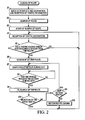
- FIG. 2 is a flow chart illustrating the route guiding program in an embodiment of the present invention. In the following, an explanation will be given regarding the operation of an embodiment with reference to this flow chart. Under controller 8, after the power is turned ON for the navigation device, the route guiding program is executed repeatedly.
- step S1 input device 7 is used to input the start site, destination and sites on the way.
- the road traffic information is received with beacon receiver 5 and FM multiplex receiver 6.
- step S2 using the well-known Dykstra method, a computation is performed for the shortest time in consideration of the newest road traffic information, and the optimum route to the destination (the shortest-time route) is searched.
- step S3 the road map around the current site is displayed on display unit 9, the shortest-time route from the current site to the destination of the vehicle is displayed on the road map, and guiding for the route is started.
- One may also adopt a scheme in which by means of the Dykstra method, computation of the shortest distance is performed, and the shortest-distance route to the destination is searched.
- step S4 road traffic information is received with beacon receiver 5 and FM multiplex receiver 6. Then, in step S5, the received road traffic information is analyzed. Generation of traffic hazards, such as a traffic restriction or traffic jam, on the optimum route to the destination, that is, generation of a traffic hazard that requires a detour from the initial optimum route, is checked.
- a traffic hazard refers to all traffic problems, such as a traffic jam, traffic restriction, road work, accidents, weather, etc., that can arise on roads.
- the process returns to step S4. Then, while guiding of the route is continued along the optimum route to the destination, traffic information is received, and generation of a traffic hazard that requires a detour is checked.
- step S6 when a traffic hazard that requires a detour from the optimum route has arisen, the process goes to step S6, and computation of the shortest time is performed using the Dykstra method. Searching is performed for a detour route to the destination with the detour occurring at the site where the traffic hazard requiring a detour has arisen.
- two types of detour routes are searched, and one of them is selected.
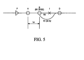
- two routes are selected from among plural candidate detour routes to destination D by detouring site I where a traffic hazard has arisen by branching from a branching site located between current site P and site I where the traffic hazard requiring a detour has arisen.
- the detour route with the shortest required time is designated optimum detour route R1
- the branching site where branching is performed from initial optimum detour route R0 to optimum detour route R1 is designated optimum branching site B1.
- last detour route R2 the last detour route prior to site I where a traffic hazard has arisen that does not require a U-turn after passing its branching site
- last branching site B2 the branching site for branching from initial optimum route R0 to last detour route R2 is designated last branching site B2.
- the following selection method is adopted to select one route from optimum detour route R1 and last detour route R2.
- the difference in the required time from current site P to destination D between optimum detour route R1 and last detour route R2, that is, the value obtained by subtracting required time T1 of optimum detour route R1 from required time T2 of last detour route R2, is designated ⁇ T.
- the difference in distance between optimum branching site B 1 from initial optimum route R0 to optimum detour route R1 and last branching site B2 from the initial optimum route R0 to last detour route R2, that is, the value obtained by subtracting distance L1 from current site P to optimum branching site B 1 from distance L2 from current site P to last branching site B2, is designated ⁇ L.
- optimum detour route R1 is selected. If not, last detour route R2 is selected.
- ⁇ T > min ⁇ k ⁇ ⁇ L , T k ⁇ Relationship (1) is shown in FIG. 4.
- k represents the slope of straight line a ;
- Tk is a threshold of the required time;
- min ⁇ k ⁇ L, Tk ⁇ is a function that selects the smaller of the variable k ⁇ L and the threshold Tk.
- step S7 after selection of the detour route, the detour route guiding site is computed.
- detour guiding is performed at site A at distance La from branching site B (optimum branching site B1 or last branching site B2) of the selected detour route (optimum detour route R1 or last detour route R2).
- detour preparation time Ta which includes the time for understanding the detour route guide, the time for judgment on whether the vehicle is to enter the detour route, the time of operation manipulation needed for changing lanes, etc.
- detour preparation time Ta corresponding to the traffic jam or other traffic state, the road type and other factors of the operating environment.
- vehicle speed V the current vehicle speed, the newest average vehicle speed in a prescribed distance interval, the speed limit up to branching site B, etc., are set.
- step S8 judgment is made on whether detour guiding site A has been reached. If detour guiding site A has been reached, the process goes to step S9. In step S9, the optimum route is searched again. That is, based on the newest road traffic information received by beacon receiver 5 and/or FM multiplex receiver 5, the route with the shortest time from the current site to the destination is searched.
- step S10 as a result of re-search of the route, it is judged whether the traffic hazard on optimum route R0 has been eliminated, and initial optimum route R0 is searched again.
- initial optimum route R0 is re-searched, detour guiding is stopped, and route guiding along initial optimum route R0 is continued. Then, the process returns to step S4, and the aforementioned process is repeated.
- step S9 If, as a result of re-search of the route in step S9, the traffic hazard on initial optimum route R0 has not been eliminated, and a detour route is to be searched, the process goes to step S 11.
- step S 11 judgment is made on whether a new detour route entirely different from optimum detour route R1 or last detour route R2 is searched. If a new detour route is to be searched, the process returns to step S7, and the aforementioned process is repeated. On the other hand, when previously searched optimum detour route R1 or last detour route R2 is re-searched, the process goes to step S12, and detour route guiding to optimum detour route R1 or last detour route R2 is announced.
- the current site is detected.
- the optimum route from the current site to the destination is searched, and guiding is performed along the optimum route to the destination.
- Traffic information is acquired, and a traffic hazard that requires a detour from the optimum route undergoes detection. If a traffic hazard that requires a detour from the optimum route is detected, the traffic hazard is detoured, and a detour route to the destination is searched. Guiding is performed concerning the detour route at a site located a prescribed distance from the branching site where branching is to be made from the optimum route. Consequently, the persons in the vehicle can appropriately judge whether the vehicle should enter the detour route.
- the distance from the branching site for the detour route to the route guiding site is determined. Consequently, it is possible to set the optimum detour route guiding site, so that the persons in the vehicle can appropriately judge whether the vehicle should enter the detour route.
- the optimum route to the destination is re-searched at a site located a prescribed distance from the branching site where branching is to be made from said optimum route. Only when the detour route for detouring to the optimum route is searched is guiding performed for the detour route. Consequently, it is possible to check whether the traffic hazard on the optimum route has been eliminated just before reaching the branching site to the detour route so that it is possible to follow the optimum route, and it is possible to avoid wasteful following of the detour route.
- either the optimum detour route or the last detour route is selected. Consequently, it is possible to avoid the problem of passing the branching site to the last detour route such that the vehicle must execute a U-turn on the optimum route, while it is possible to increase the probability of running on the initial optimum route after the traffic hazard has been eliminated.
- a detour route selecting map is set so that for a large branching site distance, the last detour route is selected, and, for a large required time difference, the optimum detour route is selected.
- the detour route selection map the optimum detour route or the last detour route is selected. Consequently, it is possible to avoid the problem of passing the branching site to the last detour route such that the vehicle must execute a U-turn on the optimum route, while it is possible to increase the probability of running on the initial optimum route after the traffic hazard has been eliminated.
- the optimum detour route is still selected. Consequently, it is possible to avoid the problem of passing the branching site to the last detour route so that the vehicle must execute a U-turn on the optimum route, while it is possible to increase the probability of running on the initial optimum route after the traffic hazard has been eliminated.
- the distance from the branching point for the detour route to the location for providing the detour route guidance is determined based on the speed of the vehicle and the preparation time for branching to the detour route.
- the optimal location for providing the detour route guidance can be established, and the driver can be prompted to appropriately judge whether to advance to the detour route.
- the optimal route to the destination is retrieved at a location that is a predetermined distance from the point for branching to the detour route from the optimal route, and provides a guide regarding the detour route only when a detour from the optimal route has been retrieved.
- the probability of being able to enter the optimal detour route can be enhanced.
- either the optimal detour route or the last detour route is selected based on the distance between the branching point to the optimal detour route from the optimal route and the branching point to the last detour route (branching point distance), and the difference between the travel time necessary to reach the destination from the present location via the optimal detour route and the travel time necessary to reach the destination via the last detour route from the present location (required time difference).
- the probability of being able to enter the optimal detour route can be enhanced.
- a detour route selection map that selects the last detour route when the branching point distance is great, and that selects the optimal detour route when the required time is great, is provided on a two dimensional plane comprised of the branching point distance and the necessary time difference, and either the optimal detour route or the last detour route is selected according to this detour route selection map.
- the optimal detour route is selected even if the branching point distance is great when the required time difference exceeds the preset threshold value.
- the probability of being able to enter the optimal detour route can be enhanced.
- FIG. 6 shows a flow chart of the route guidance program in this modified example. The steps that perform the same processes as in the flow chart shown in FIG. 2 are given the same step numbers, and explanations of FIG. 6 will focus on areas of difference with FIG. 2.
- step S1 the starting location, destination and the route are input from input device 7, and road traffic information is transmitted from beacon receiver 5 and/or FM multiplex receiver 6.
- step S2 the optimal route to the destination is retrieved by carrying out a calculation for the shortest cost in time, taking into consideration the road traffic information, according to the Dykstra method, or the optimal route to the destination is retrieved by carrying out a calculation for the shortest distance, as described above.
- step S3 a road map of the present location and the optimal route from the current location of the vehicle to the destination are displayed on display 9, and road guidance begins.
- step S4 road traffic information is received by beacon receiver 5 and/or FM multiplex receiver 6.
- step S5 the road traffic information is analyzed, and a check is performed for development of traffic problems, such as restricted roads and traffic jams, along the optimal route to the destination, i.e., traffic problems that require a detour from the initial optimal route. If a traffic jam that needs to be detoured around has not developed on the optimal route, process flow returns to step S4 in which traffic information is received so that checks can again be performed for development of traffic problems and so that road guidance along the optimal route to the destination can continue. On the other hand, if a traffic problem develops on the optimum route that needs to be detoured around, process flow proceeds to step S6. In step S6, a calculation for the shortest time or the shortest distance is performed according to the Dykstra method, and a detour route to the destination is retrieved that goes around the location with the traffic problem.
- the method for retrieving the detour route is the same as the retrieval method in the previous example.
- the optimum detour route R1 requiring the shortest time or shortest distance for branching at the optimum branching point B1 and last detour route R2 for branching from the last branching point B2 are extracted from the plurality of detour route candidates for reaching destination D while avoiding traffic problem location I.
- one of the detour routes is selected according to equation (1) based on the difference ⁇ T between the time required T1 for optimum detour route R1 and the time required T2 for the last detour route R2 and the distance ⁇ L from optimum branching point B1 to last branching point B2.
- detour route guidance location detour guiding site A
- step S7 the detour route guidance location, detour guiding site A
- distance La from branching point B back to guiding site A is obtained according to equation (2) based on detour preparation time Ta and vehicle speed V.
- Detour route guidance is provided at site A that is distance La from branching point B (optimum branching point B1 or last branching point B2) for the selected detour route (optimum detour route R1 or last detour route R2).
- step S8 whether the detour guiding site A has been reached is checked, and if detour guiding site A has been reached, process flow proceeds to step S12, and the detour route guidance to the optimum detour route R1 or the last detour route R2 is revealed.
- a traffic problem on the optimum route that needs to be avoided is detected by obtaining the traffic information.
- the detour route requiring the shortest travel time to reach the destination by detouring around the traffic problem is retrieved when a problem requiring a detour is detected, and guidance related to the detour route is provided at a location that is an optimal distance from the point for branching from the optimum route to the detour route. This makes it possible to prompt the driver to judge whether to advance to the detour route.
- detour route guidance can be provided at the optimum location, making it is possible to avoid missing the optimum detour route as was the case in the prior art.
- a traffic problem on the optimum route that needs to be detoured around is detected by obtaining the traffic information.
- the detour route that requires the shortest distance to reach the destination by detouring around the traffic problem is retrieved when a traffic problem that needs to be avoided is detected on the optimum route, and guidance related to the detour route is provided at a location that is an optimal distance from the point for branching from the optimum route to the detour route. This makes it possible to prompt the driver to judge whether to advance to the detour route.
- detour route guidance can be provided at the optimum location, making it is possible to avoid missing the optimal detour route as was the case in the prior art.
- the search for the optimum route to the destination, the optimum detour route and the last detour route are executed in the vehicle.
- the optimum detour route or the last detour route is selected at the information center, and the signal of the route of the search result is sent to the vehicle.
Landscapes
- Engineering & Computer Science (AREA)
- Radar, Positioning & Navigation (AREA)
- Remote Sensing (AREA)
- Physics & Mathematics (AREA)
- General Physics & Mathematics (AREA)
- Mathematical Physics (AREA)
- Automation & Control Theory (AREA)
- Navigation (AREA)
- Instructional Devices (AREA)
- Traffic Control Systems (AREA)
Applications Claiming Priority (2)
| Application Number | Priority Date | Filing Date | Title |
|---|---|---|---|
| JP2005097317 | 2005-03-30 | ||
| JP2005327042A JP4807043B2 (ja) | 2005-03-30 | 2005-11-11 | 経路誘導装置および方法 |
Publications (3)
| Publication Number | Publication Date |
|---|---|
| EP1710768A2 true EP1710768A2 (de) | 2006-10-11 |
| EP1710768A3 EP1710768A3 (de) | 2009-09-16 |
| EP1710768B1 EP1710768B1 (de) | 2010-10-13 |
Family
ID=36570478
Family Applications (1)
| Application Number | Title | Priority Date | Filing Date |
|---|---|---|---|
| EP06251698A Expired - Lifetime EP1710768B1 (de) | 2005-03-30 | 2006-03-29 | Navigationssystem und -verfahren |
Country Status (5)
| Country | Link |
|---|---|
| US (1) | US7536259B2 (de) |
| EP (1) | EP1710768B1 (de) |
| JP (1) | JP4807043B2 (de) |
| CN (1) | CN1841024B (de) |
| DE (1) | DE602006017463D1 (de) |
Cited By (3)
| Publication number | Priority date | Publication date | Assignee | Title |
|---|---|---|---|---|
| CN111060125A (zh) * | 2019-12-30 | 2020-04-24 | 深圳一清创新科技有限公司 | 碰撞检测方法、装置、计算机设备和存储介质 |
| US11164456B2 (en) | 2007-02-12 | 2021-11-02 | Carma Technology Limited | Systems and methods for matching pick-up requests with transport providers, tracking trip progress, and enabling provider ratings |
| US12620310B2 (en) | 2025-09-23 | 2026-05-05 | Carma Technology Limited | Systems and methods for delivery verification in a shared transport network |
Families Citing this family (22)
| Publication number | Priority date | Publication date | Assignee | Title |
|---|---|---|---|---|
| JP4479484B2 (ja) * | 2004-11-29 | 2010-06-09 | 株式会社デンソー | 車載ナビゲーション装置 |
| JP4736979B2 (ja) * | 2006-06-30 | 2011-07-27 | 日産自動車株式会社 | 車載装置、交通情報取得方法、交通情報提供システム及び交通情報提供方法 |
| CN101852621B (zh) * | 2009-03-31 | 2014-05-07 | 阿尔派株式会社 | 导航装置和导航装置的路径探索方法 |
| CN101995252B (zh) * | 2009-08-19 | 2014-07-30 | 阿尔派株式会社 | 导航装置及该导航装置的道路信息提示方法 |
| CN101788302B (zh) * | 2010-01-26 | 2012-02-22 | 东软集团股份有限公司 | 导航装置及其方法 |
| US8700327B2 (en) | 2010-04-27 | 2014-04-15 | Honda Motor Co., Ltd. | Method of determining routes for use in navigation |
| CN101867603A (zh) * | 2010-05-21 | 2010-10-20 | 深圳积享通信息技术有限公司 | 一种特定区域内移动终端的自动识别方法 |
| CN101860790A (zh) * | 2010-05-21 | 2010-10-13 | 深圳积享通信息技术有限公司 | 一种基于移动终端位置信息的数据自动匹配方法 |
| JP5184613B2 (ja) * | 2010-11-26 | 2013-04-17 | 本田技研工業株式会社 | ナビサーバ、ナビ装置およびナビシステム |
| KR20130065126A (ko) * | 2011-12-09 | 2013-06-19 | 한국전자통신연구원 | 이동체의 경로 설정 장치 및 방법 |
| CN103852772A (zh) * | 2012-11-29 | 2014-06-11 | 北京千橡网景科技发展有限公司 | 导航方法、导航装置及导航仪 |
| US8843303B1 (en) * | 2012-12-17 | 2014-09-23 | Rockwell Collins, Inc. | Risk-aware contingency flight re-planner system and related method |
| JP2015017949A (ja) * | 2013-07-12 | 2015-01-29 | アイシン・エィ・ダブリュ株式会社 | 運転支援システム、方法およびプログラム |
| JP6479399B2 (ja) * | 2014-10-14 | 2019-03-06 | 古野電気株式会社 | 航行ルート生成装置、自動操舵システム及び航行ルート生成方法 |
| JP6037468B2 (ja) * | 2014-11-14 | 2016-12-07 | インターナショナル・ビジネス・マシーンズ・コーポレーションInternational Business Machines Corporation | 移動体が特定領域に接近していることを通知する方法、並びに、その為のサーバ・コンピュータ及びサーバ・コンピュータ・プログラム |
| US10893380B2 (en) | 2016-03-16 | 2021-01-12 | Nec Corporation | Guidance assistance apparatus, guidance assistance method, and storage medium for storing program |
| JP6777151B2 (ja) * | 2016-08-16 | 2020-10-28 | 日産自動車株式会社 | ルート探索方法及びルート探索装置 |
| JP7151090B2 (ja) * | 2018-02-07 | 2022-10-12 | トヨタ自動車株式会社 | 道路障害特定システムおよび道路障害特定方法 |
| EP3777255A4 (de) * | 2018-03-30 | 2021-12-08 | Rhapsody International Inc. | Adaptive prädiktive cache-systeme und verfahren |
| US11022453B2 (en) | 2018-09-21 | 2021-06-01 | International Business Machines Corporation | Alternative route decision making |
| JP6994016B2 (ja) * | 2019-11-22 | 2022-01-14 | 株式会社エヌ・ティ・ティ・データ | 経路探索装置及び経路探索方法 |
| JP7484639B2 (ja) * | 2020-09-30 | 2024-05-16 | トヨタ自動車株式会社 | 運行管理装置、運行管理方法、運行管理システム、及び車両 |
Citations (2)
| Publication number | Priority date | Publication date | Assignee | Title |
|---|---|---|---|---|
| EP0871010A2 (de) | 1997-04-08 | 1998-10-14 | Aisin Aw Co., Ltd. | Fahrzeugnavigationsvorrichtung |
| JP2001349735A (ja) | 2000-06-08 | 2001-12-21 | Denso Corp | 経路設定装置及びナビゲーション装置 |
Family Cites Families (14)
| Publication number | Priority date | Publication date | Assignee | Title |
|---|---|---|---|---|
| JP3214181B2 (ja) * | 1993-09-14 | 2001-10-02 | トヨタ自動車株式会社 | 車載用ナビゲーション装置 |
| JP3465666B2 (ja) * | 1993-12-22 | 2003-11-10 | 日産自動車株式会社 | 車両用経路誘導装置 |
| JP3340857B2 (ja) * | 1994-09-22 | 2002-11-05 | アルパイン株式会社 | 車載用ナビゲーション装置 |
| US5612882A (en) * | 1995-02-01 | 1997-03-18 | Lefebvre; Rebecca K. | Method and apparatus for providing navigation guidance |
| US5911773A (en) * | 1995-07-24 | 1999-06-15 | Aisin Aw Co., Ltd. | Navigation system for vehicles |
| JPH1082647A (ja) * | 1996-09-05 | 1998-03-31 | Mitsubishi Electric Corp | 移動体用ナビゲーション装置 |
| DE19956108A1 (de) * | 1999-11-22 | 2001-05-23 | Mannesmann Vdo Ag | Verfahren zur dynamischen Zielführung eines Kraftfahrzeugs |
| JP2001227965A (ja) * | 2000-02-14 | 2001-08-24 | Fujitsu Ten Ltd | ナビゲーション装置 |
| JP4643031B2 (ja) * | 2001-01-31 | 2011-03-02 | クラリオン株式会社 | 経路探索装置 |
| JP2003214879A (ja) * | 2002-01-17 | 2003-07-30 | Alpine Electronics Inc | ナビゲーション装置 |
| DE10218636A1 (de) * | 2002-04-25 | 2003-11-06 | Daimler Chrysler Ag | Verfahren zur Information von Fahrzeugführern über Änderungen der optimalen Route |
| JP4069378B2 (ja) * | 2002-12-18 | 2008-04-02 | アイシン・エィ・ダブリュ株式会社 | ナビゲーション装置並びに該装置用プログラム及び記録媒体 |
| JP4452474B2 (ja) * | 2003-09-30 | 2010-04-21 | パイオニア株式会社 | 案内誘導システム、その方法、そのプログラム、および、そのプログラムを記録した記録媒体 |
| JP4556163B2 (ja) * | 2004-03-31 | 2010-10-06 | アイシン・エィ・ダブリュ株式会社 | ナビゲーション装置 |
-
2005
- 2005-11-11 JP JP2005327042A patent/JP4807043B2/ja not_active Expired - Fee Related
-
2006
- 2006-03-18 US US11/378,548 patent/US7536259B2/en not_active Expired - Fee Related
- 2006-03-29 EP EP06251698A patent/EP1710768B1/de not_active Expired - Lifetime
- 2006-03-29 DE DE602006017463T patent/DE602006017463D1/de not_active Expired - Lifetime
- 2006-03-30 CN CN2006100665316A patent/CN1841024B/zh not_active Expired - Fee Related
Patent Citations (2)
| Publication number | Priority date | Publication date | Assignee | Title |
|---|---|---|---|---|
| EP0871010A2 (de) | 1997-04-08 | 1998-10-14 | Aisin Aw Co., Ltd. | Fahrzeugnavigationsvorrichtung |
| JP2001349735A (ja) | 2000-06-08 | 2001-12-21 | Denso Corp | 経路設定装置及びナビゲーション装置 |
Cited By (18)
| Publication number | Priority date | Publication date | Assignee | Title |
|---|---|---|---|---|
| US11295618B2 (en) | 2007-02-12 | 2022-04-05 | Carma Technology Limited | Systems and methods for verifying vehicle occupancy |
| US11308803B2 (en) | 2007-02-12 | 2022-04-19 | Carma Technology Limited | Systems and methods for identity verification in a shared transport system |
| US11164456B2 (en) | 2007-02-12 | 2021-11-02 | Carma Technology Limited | Systems and methods for matching pick-up requests with transport providers, tracking trip progress, and enabling provider ratings |
| US11210947B2 (en) | 2007-02-12 | 2021-12-28 | Carma Technology Limited | Continuous coordinated proximity monitoring in a shared transport network |
| US11250705B2 (en) | 2007-02-12 | 2022-02-15 | Carma Technology Limited | Systems and methods for performing traffic flow data analytics in a shared transport system |
| US11263904B2 (en) | 2007-02-12 | 2022-03-01 | Carma Technology Limited | Systems and methods for verifying high-occupancy vehicle journeys and determining preferential road allowances |
| US11270584B2 (en) | 2007-02-12 | 2022-03-08 | Carma Technology Limited | Systems and methods for determining fare amounts for transit services |
| US11288960B2 (en) | 2007-02-12 | 2022-03-29 | Carma Technology Limited | Systems and methods for applying ratings for transport services |
| US12579890B2 (en) | 2007-02-12 | 2026-03-17 | Carma Technology Limited | Ride matching to a destination category or purpose in a shared transport system |
| US12087162B2 (en) | 2007-02-12 | 2024-09-10 | Carma Technology Ltd. | Systems and methods for ETA calculation in a shared transport system |
| US11302190B2 (en) | 2007-02-12 | 2022-04-12 | Carma Technology Limited | Systems and methods for a trusted transit network in a shared transport system |
| US11538339B2 (en) | 2007-02-12 | 2022-12-27 | Carma Technology Limited | Systems and methods for generating vehicle indicators for signaling assigned transport vehicles |
| US11538340B2 (en) | 2007-02-12 | 2022-12-27 | Carma Technology Limited | Systems and methods for verifying a shared journey in a shared transport system |
| US11568742B2 (en) | 2007-02-12 | 2023-01-31 | Carma Technology Limited | Systems and methods for utilizing a shared transport network with a transport provider destination mode |
| US11574542B2 (en) | 2007-02-12 | 2023-02-07 | Carma Technology Limited | Systems and methods for providing safety for drivers and riders in a shared transport system |
| CN111060125A (zh) * | 2019-12-30 | 2020-04-24 | 深圳一清创新科技有限公司 | 碰撞检测方法、装置、计算机设备和存储介质 |
| CN111060125B (zh) * | 2019-12-30 | 2021-09-17 | 深圳一清创新科技有限公司 | 碰撞检测方法、装置、计算机设备和存储介质 |
| US12620310B2 (en) | 2025-09-23 | 2026-05-05 | Carma Technology Limited | Systems and methods for delivery verification in a shared transport network |
Also Published As
| Publication number | Publication date |
|---|---|
| DE602006017463D1 (de) | 2010-11-25 |
| US7536259B2 (en) | 2009-05-19 |
| US20060224302A1 (en) | 2006-10-05 |
| CN1841024B (zh) | 2012-09-05 |
| CN1841024A (zh) | 2006-10-04 |
| EP1710768B1 (de) | 2010-10-13 |
| JP2006308548A (ja) | 2006-11-09 |
| JP4807043B2 (ja) | 2011-11-02 |
| EP1710768A3 (de) | 2009-09-16 |
Similar Documents
| Publication | Publication Date | Title |
|---|---|---|
| EP1710768B1 (de) | Navigationssystem und -verfahren | |
| US6947833B2 (en) | Road traffic information processing apparatus, road traffic information processing method, computer program, and information record medium | |
| US6941222B2 (en) | Navigation system, server system for a navigation system, and computer-readable information recorded medium in which destination prediction program is recorded | |
| US6807482B2 (en) | Navigation apparatus and navigation method | |
| JP4622676B2 (ja) | 車載ナビゲーション装置 | |
| JP2006053109A (ja) | 車両用ナビゲーション装置及び車両用ナビゲーション装置の経路案内方法 | |
| KR101570827B1 (ko) | 차로변경행태를 고려한 안전운전 경로 안내 장치 및 방법 | |
| EP1413855A2 (de) | Routenbereitstellungsgerät, Routenbereitstellungsverfahren, Navigationssystem, und Komputerprogramm für das Routenbereitstellungsgerät oder das Navigationssystem | |
| KR102523103B1 (ko) | 협소 도로 구간의 환경을 고려한 차량의 주행 경로 안내 장치 및 그 동작 방법 | |
| JP5026177B2 (ja) | 交通情報を表示するナビゲーション装置、交通情報表示方法 | |
| JP2008292415A (ja) | ナビゲーション装置 | |
| JP2009250869A (ja) | ナビゲーション装置 | |
| KR100451439B1 (ko) | 차량용 네비게이션 시스템 및 그 제어 방법 | |
| JP2007322183A (ja) | 車載用ナビゲーション装置 | |
| JP2007285998A (ja) | ナビゲーション装置および迂回経路作成方法 | |
| JP5010951B2 (ja) | 車載地図表示装置 | |
| JP5276970B2 (ja) | ナビゲーション装置 | |
| JP2007322304A (ja) | ナビゲーション装置、ナビゲーション方法 | |
| KR101099977B1 (ko) | 네비게이션 장치에서의 주행 상황 표시 방법 및 이를 위한 네비게이션 장치 | |
| JP5144961B2 (ja) | ナビゲーション装置 | |
| JP2008139081A (ja) | ナビゲーション装置 | |
| JP2008267815A (ja) | 車載用ナビゲーション装置 | |
| JP2010008070A (ja) | ナビゲーション装置、ナビゲーション方法、ナビゲーションプログラム、および記録媒体 | |
| JP4645272B2 (ja) | ナビゲーション装置 | |
| JP2007085989A (ja) | ナビゲーション装置 |
Legal Events
| Date | Code | Title | Description |
|---|---|---|---|
| PUAI | Public reference made under article 153(3) epc to a published international application that has entered the european phase |
Free format text: ORIGINAL CODE: 0009012 |
|
| AK | Designated contracting states |
Kind code of ref document: A2 Designated state(s): AT BE BG CH CY CZ DE DK EE ES FI FR GB GR HU IE IS IT LI LT LU LV MC NL PL PT RO SE SI SK TR |
|
| AX | Request for extension of the european patent |
Extension state: AL BA HR MK YU |
|
| PUAL | Search report despatched |
Free format text: ORIGINAL CODE: 0009013 |
|
| AK | Designated contracting states |
Kind code of ref document: A3 Designated state(s): AT BE BG CH CY CZ DE DK EE ES FI FR GB GR HU IE IS IT LI LT LU LV MC NL PL PT RO SE SI SK TR |
|
| AX | Request for extension of the european patent |
Extension state: AL BA HR MK YU |
|
| 17P | Request for examination filed |
Effective date: 20091005 |
|
| 17Q | First examination report despatched |
Effective date: 20091030 |
|
| AKX | Designation fees paid |
Designated state(s): DE FR GB |
|
| GRAP | Despatch of communication of intention to grant a patent |
Free format text: ORIGINAL CODE: EPIDOSNIGR1 |
|
| RAP1 | Party data changed (applicant data changed or rights of an application transferred) |
Owner name: NISSAN MOTOR CO., LTD. |
|
| GRAS | Grant fee paid |
Free format text: ORIGINAL CODE: EPIDOSNIGR3 |
|
| GRAA | (expected) grant |
Free format text: ORIGINAL CODE: 0009210 |
|
| AK | Designated contracting states |
Kind code of ref document: B1 Designated state(s): DE FR GB |
|
| REG | Reference to a national code |
Ref country code: GB Ref legal event code: FG4D |
|
| REF | Corresponds to: |
Ref document number: 602006017463 Country of ref document: DE Date of ref document: 20101125 Kind code of ref document: P |
|
| PLBE | No opposition filed within time limit |
Free format text: ORIGINAL CODE: 0009261 |
|
| STAA | Information on the status of an ep patent application or granted ep patent |
Free format text: STATUS: NO OPPOSITION FILED WITHIN TIME LIMIT |
|
| 26N | No opposition filed |
Effective date: 20110714 |
|
| REG | Reference to a national code |
Ref country code: DE Ref legal event code: R097 Ref document number: 602006017463 Country of ref document: DE Effective date: 20110714 |
|
| PGFP | Annual fee paid to national office [announced via postgrant information from national office to epo] |
Ref country code: FR Payment date: 20140311 Year of fee payment: 9 |
|
| PGFP | Annual fee paid to national office [announced via postgrant information from national office to epo] |
Ref country code: GB Payment date: 20140326 Year of fee payment: 9 |
|
| PGFP | Annual fee paid to national office [announced via postgrant information from national office to epo] |
Ref country code: DE Payment date: 20140417 Year of fee payment: 9 |
|
| REG | Reference to a national code |
Ref country code: DE Ref legal event code: R119 Ref document number: 602006017463 Country of ref document: DE |
|
| GBPC | Gb: european patent ceased through non-payment of renewal fee |
Effective date: 20150329 |
|
| REG | Reference to a national code |
Ref country code: FR Ref legal event code: ST Effective date: 20151130 |
|
| PG25 | Lapsed in a contracting state [announced via postgrant information from national office to epo] |
Ref country code: GB Free format text: LAPSE BECAUSE OF NON-PAYMENT OF DUE FEES Effective date: 20150329 Ref country code: DE Free format text: LAPSE BECAUSE OF NON-PAYMENT OF DUE FEES Effective date: 20151001 |
|
| PG25 | Lapsed in a contracting state [announced via postgrant information from national office to epo] |
Ref country code: FR Free format text: LAPSE BECAUSE OF NON-PAYMENT OF DUE FEES Effective date: 20150331 |